Einträge mit Themengebiet "Institut für Methodik der Fernerkundung > SAR-Signalverarbeitung"
 | Eine Ebene höher |
- Institute und Einrichtungen (150161)
- Institut für Methodik der Fernerkundung (6998)
- SAR-Signalverarbeitung (1595)
- Institut für Methodik der Fernerkundung (6998)
| Eineder, Michael und Roth, Achim und Moreira, Alberto, eds. (2019) Ten Years of TerraSAR-X - Scientific Results. Remote Sensing. MDPI. doi: 10.3390/books978-3-03897-725-4. ISBN 978-3-03897-725-4. |  |
| Topouzelis, Konstantinos und Papakonstantinou, Apostolos und Singha, Suman und Li, Xiao-Ming und Poursanidis, Dimitris, eds. (2020) Applications of Remote Sensing in Coastal Areas. Remote Sensing. MDPI. doi: 10.3390/books978-3-03928-659-1. ISBN 978-3-03928-658-4. Volltext nicht online. |
| Dabboor, Mohammed und Brisco, Brian und Singha, Suman und Geldsetzer, Torsten, eds. (2020) Special Issue: Compact Polarimetric SAR. Remote Sensing. MDPI. Volltext nicht online. |
| Nunziata, Ferdinando und Marino, Armando und Velotto, Domenico, eds. (2020) Special Issue: Remote Sensing of Target Detection in Marine Environment. Remote Sensing. MDPI. Volltext nicht online. |
| Abdel Jaber, Wael (2016) Derivation of mass balance and surface velocity of glaciers by means of high resolution synthetic aperture radar: application to the Patagonian Icefields and Antarctica. DLR-Forschungsbericht. 2016-54. Dissertation. Technische Universität München. 236 S. | |
| Abdel Jaber, Wael und Floricioiu, Dana und Johnson, Erling und Rott, Helmut (2017) Recent surface elevation changes of patagonian glaciers derived with TanDEM-X. In: Proceedings of IEEE International Geoscience and Remote Sensing Symposium (IGARSS) 2017, Seiten 2821-2824. IEEE Xplore. 2017 IEEE International Geoscience and Remote Sensing Symposium (IGARSS), 2017-07-23 - 2017-07-28, Fort Worth, USA. doi: 10.1109/igarss.2017.8127585. Volltext nicht frei. | |
| Abdel Jaber, Wael und Floricioiu, Dana und Rott, Helmut (2014) Glacier dynamics of the Northern Patagonia Icefield derived from SRTM, TanDEM-X and TerraSAR-X data. In: IEEE International Geoscience and Remote Sensing Symposium (IGARSS), 2014, Seiten 4018-4021. IEEE Xplore. IGARSS 2014, 2014-07-13 - 2014-07-18, Quebec, Kanada. doi: 10.1109/IGARSS.2014.6947367. Volltext nicht frei. | |
| Abdel Jaber, Wael und Floricioiu, Dana und Rott, Helmut (2016) Geodetic mass balance of the Patagonian Icefields derived from SRTM and TanDEM-X data. In: Proceedings of IGARSS 2016, Seiten 342-345. IEEE Xplore. IGARSS 2016, 2016-07-10 - 2016-07-15, Beijing, China. doi: 10.1109/IGARSS.2016.7729082. ISSN 2153-7003. | |
| Abdel Jaber, Wael und Floricioiu, Dana und Rott, Helmut und Eineder, Michael (2012) Dynamics of fast glaciers in the Patagonia Icefields derived from TerraSAR-X and TanDEM-X data. In: International Geoscience and Remote Sensing Symposium (IGARSS), 3226 -3229. IEEE - Institute of Electrical and Electronics Engineers. IGARSS 2012, 2012-07-22 - 2012-07-27, München, Deutschland. doi: 10.1109/IGARSS.2012.6350737. ISBN 978-1-4673-1160-1. ISSN 2153-6996. Volltext nicht online. |
| Abdel Jaber, Wael und Floricioiu, Dana und Rott, Helmut und Eineder, Michael (2013) Surface elevation changes of glaciers derived from SRTM and TanDEM-X DEM differences. In: IEEE International Geoscience and Remote Sensing Symposium (IGARSS), Seiten 1893-1896. IEEE - Institute of Electrical and Electronics Engineers. IGARSS 2013, 2013-07-21 - 2013-07-26, Melbourne, Australia. doi: 10.1109/igarss.2013.6723173. ISBN 978-1-4799-1114-1/13. Volltext nicht online. |
| Abdel Jaber, Wael und Rott, Helmut und Floricioiu, Dana und Wuite, Jan und Miranda, Nuno (2019) Heterogeneous spatial and temporal pattern of surface elevation change and mass balance of the Patagonian ice fields between 2000 and 2016. The Cryosphere, 13, Seiten 2511-2535. Copernicus Publications. doi: 10.5194/tc-13-2511-2019. ISSN 1994-0416. | |
| Abdela, Nesredin Kenzu und Lachaise, Marie und Schweißhelm, Barbara (2025) Calibration of TanDEM-X DEM Scenes Using Icesat-2 Altimetry Data for Global Dem Change Maps. In: International Geoscience and Remote Sensing Symposium (IGARSS), Seiten 3920-3923. IGARSS, 2025-08-03 - 2025-08-08, Brisbane, Australia. doi: 10.1109/IGARSS55030.2025.11242835. Volltext nicht frei. | |
| Adam, Nico und Gernhardt, Stefan und Eineder, Michael und Bamler, Richard (2010) Multi Beam Joined Estimation For Persistent Scatterer Interferometry. In: Proceedings of IGARSS 2010, Seiten 4403-4406. IEEE. IGARSS 2010, 2010-07-25 - 2010-07-30, Honolulu, USA. ISBN 978-1-4244-9566-5. Volltext nicht online. |
| Adam, Nico und Rodriguez Gonzalez, Fernando und Parizzi, Alessandro (2011) Differential Interferometry Applications. 20 Years Antarctic Research Station GARS O'Higgins, 2011-11-12 - 2011-11-15, Punta Arenas, Chile. Volltext nicht online. |
| Adam, Nico und Rodriguez Gonzalez, Fernando und Parizzi, Alessandro und Brcic, Ramon (2013) Wide Area Persistent Scatterer Interferometry: Current Developments, algorithms and Examples. In: Proceedings of the IEEE International Geoscience and Remote Sensing Symposium, Seiten 1-4. the Institute of Electrical and Electronics Engineers. IGARSS 2013, 2013-07-22 - 2013-07-26, Melbourne, Australien. doi: 10.1109/igarss.2013.6723164. Volltext nicht online. |
| Adam, Fathalrahman (2014) Non-local Filtering of TanDEM-X Interferograms for Improving DEM Quality. Masterarbeit, Technische Universität München. Volltext nicht online. |
| Adam, Nico Alexander (2014) Algorithmic PSI Improvement in Mountainous Areas by Atmosphere Mitigation. Projektbericht. DLR Oberpfaffenhofen. 98 S. | |
| Adam, Nico Alexander (2018) The Development of a High Precision Troposphere Effect Mitigation Processor for SAR Interferometry. In: Proceedings of IGARSS 2018, Seiten 1-4. IEEE Xplore. IGARSS 2018, 2018-07-23 - 2018-07-27, Valencia, Spanien. doi: 10.1109/igarss.2018.8518618. | |
| Adam, Nico Alexander (2019) Methodology of a Troposphere Effect Mitigation Processor for SAR Interferometry. IEEE Journal of Selected Topics in Applied Earth Observations and Remote Sensing, 12 (12), Seiten 5334-5344. IEEE - Institute of Electrical and Electronics Engineers. doi: 10.1109/JSTARS.2019.2957919. ISSN 1939-1404. | |
| Adam, Nico Alexander (2022) Empirical Bayesian Estimation of the Interferometric SAR Coherence Magnitude. IEEE Journal of Selected Topics in Applied Earth Observations and Remote Sensing, 15, Seiten 6306-6323. IEEE - Institute of Electrical and Electronics Engineers. doi: 10.1109/JSTARS.2022.3192894. ISSN 1939-1404. | |
| Adam, Nico Alexander (2023) Interferometric SAR Coherence Magnitude Estimation by Machine Learning. IEEE Journal of Selected Topics in Applied Earth Observations and Remote Sensing, 16, Seiten 3034-3044. IEEE - Institute of Electrical and Electronics Engineers. doi: 10.1109/JSTARS.2023.3257047. ISSN 1939-1404. | |
| Adam, Nico Alexander (2024) SAR Coherence Estimation by Composition of Subsample Estimates and Machine Learning. IEEE Journal of Selected Topics in Applied Earth Observations and Remote Sensing, 17, Seiten 15957-15970. IEEE - Institute of Electrical and Electronics Engineers. doi: 10.1109/JSTARS.2024.3421670. ISSN 1939-1404. | |
| Adam, Nico Alexander (2025) Improved SAR Coherence Magnitude Estimates in Scenarios with Low Coherence and Small Sample Size. Dissertation, Universität der Bundeswehr München. | |
| Adam, Nico Alexander und Cong, XiaoYing und Rodriguez Gonzalez, Fernando (2012) Atmosphere Mitigation in Mountainous Areas for Persistent Scatterer Interferometry. In: Proceedings of the IEEE International Geoscience and Remote Sensing Symposium. the Institute of Electrical and Electronics Engineers. IGARSS 2012, 2012-07-22 - 2012-07-27, München, Deutschland. ISBN 978-1-4673-1160-1. Volltext nicht online. |
| Adam, Nico Alexander und Eineder, Michael (2006) A three dimensional dominant scatterer map extends the dem information in urban areas. In: ISPRS Archives – Volume XXXVI Part 1, 2006, 182, Seiten 5-9. ISPRS Archives. ISPRS Commission I Symposium, 2006-05-04 - 2006-05-06, Paris, Frankreich. | |
| Adam, Nico Alexander und Eineder, Michael und Schättler, Birgit und Yague-Martinez, Nestor (2007) First TerraSAR-X interferometry evaluation. In: Proceedings of Fringe 2007, SP-649. ESA spacebooks-online. Fringe 2007, 2007-11-26 - 2007-11-30, Frascati, Italy. ISBN 92-9291-213-3. | |
| Adam, Nico Alexander und Kampes, Bert und Eineder, Michael und Worawattanamateekul, Jirathana und Kircher, Michaela (2003) The development of a scientific permanent scatterer system. In: Proceedings of the Joint ISPRS/EARSeL Workshop “High Resolution Mapping from Space 2003”. ISPRS. ISPRS Workshop High Resolution Mapping from Space, 2003-10-06 - 2003-10-08, Hannover, Germany. | |
| Adam, Nico Alexander und Parizzi, Alessandro und Eineder, Michael und Crosetto, Michele (2009) Practical persistent scatterer processing validation in the course of the Terrafirma project. Journal of Applied Geophysics, 69 (1), Seiten 59-65. Elsevier. ISSN 0926-9851. | |
| Adam, Nico Alexander und Parizzi, Alessandro und Eineder, Michael und Crosetto, Michele (2007) Persistent scatterer processing validation in the course of the Terrafirma project. In: Proceedings of FRINGE 2007, SP-649, Seiten 1-7. ESA spacebooks-online. Fringe 2007, 2007-11-26 - 2007-11-30, Frascati, Italy. ISBN 92-9291-213-3. | |
| Adam, Nico Alexander und Reulke, Ralf und Spreckels, Volker (2020) Neues Normungsverfahren „InSAR – Radarinterferometrie für die Bodenbewegungserfassung“. In: 40. Wissenschaftlich-Technische Jahrestagung der DGPF, 29, Seiten 87-98. Deutsche Gesellschaft für Photogrammetrie, Fernerkundung und Geoinformation. 40. Wissenschaftlich-Technische Jahrestagung der DGPF, 2020-03-04 - 2020-03-06, Stuttgart. ISSN 0942-2870. | |
| Adam, Nico Alexander und Rodriguez Gonzalez, Fernando und Parizzi, Alessandro und Liebhart, Werner (2011) Wide Area Persistent Scatterer Interferometry: Algorithms and Examples. In: Proceedings of Fringe 2011 (ESA SP), Seiten 1-5. ESA Communications, ESTEC, Noordwijk, The Netherlands. FRINGE 2011, 2013-09-19 - 2013-09-23, Frascati, Italien. ISBN 978-92-9092-261-2. ISSN 1609-042X. | |
| Adam, Nico Alexander und Rodriguez Gonzalez, Fernando und Parizzi, Alessandro und Liebhart, Werner (2011) Wide Area Persistent Scatterer Interferometry. In: Proceedings of the 2011 IEEE International Geoscience and Remote Sensing Symposium, Seiten 1481-1484. the Institute of Electrical and Electronics Engineers. IGARSS 2011, 2011-07-24 - 2011-07-29, Vancouver, Kanada. doi: 10.1109/IGARSS.2011.6049347. ISBN 978-1-4577-1003-2. Volltext nicht online. |
| Adam, Nico Alexander und Zhu, Xiao Xiang und Bamler, Richard (2009) Coherent Stacking with TerraSAR-X Imagery in Urban Areas. In: Proceedings of 2009 Urban Remote Sensing Joint Event, Seiten 1-6. 2009 Urban Remote Sensing Joint Event, 2009-05-20 - 2009-05-22, Shanghai, China. doi: 10.1109/URS.2009.5137488. ISBN 978-1-4244-3460-2. ISSN 2334-0932. Volltext nicht online. |
| Adam, Nico Alexander und Zhu, Xiao Xiang und Minet, Christian und Liebhart, Werner und Eineder, Michael und Bamler, Richard (2009) Techniques and Examples for the 3D Reconstruction of complex Scattering Situations using TerraSAR-X. In: Proceedings of IGARSS 2009, Seiten 900-903. IGARSS 2009, 2009-07-13 - 2009-07-17, Cape Town, South Africa. | |
| Adolph, Winny und Farke, Hubert und Lehner, Susanne und Ehlers, Manfred (2018) Remote Sensing Intertidal Flats with Terra-SAR-X. A SAR Perspective of the structural elements of the tidal basin for Monitoring the Wadden Sea. Remote Sensing, 10 (1085), Seiten 1-23. Multidisciplinary Digital Publishing Institute (MDPI). doi: 10.3390/rs10071085. ISSN 2072-4292. | |
| Adolph, Winny und Jung, Richard und Schmidt, Alena und Ehlers, Manfred und Heipke, Christian und Bartholomä, Alexander und Farke, Hubert (2017) Integration of TerraSAR-X, RapidEye and airborne lidar for remote sensing of intertidal bedforms on the upper flats of Norderney (German Wadden Sea). Geo-Marine Letters, 37 (2), Seiten 193-205. Springer. doi: 10.1007/s00367-016-0485-z. ISSN 0276-0460. Volltext nicht online. |
| Adolph, Winny und Schückel, Ulrike und Son, Chang Soo und Jung, Richard und Bartholomä, Alexander und Ehlers, Manfred und Kröncke, Ingrid und Lehner, Susanne und Farke, Hubert (2017) Monitoring spatiotemporal trends in intertidal bedforms of the German Wadden Sea in 2009–2015 with TerraSAR-X, including links with sediments and benthic macrofauna. Geo-Marine Letters, 37 (2), Seiten 79-91. Springer. doi: 10.1007/s00367-016-0478-y. ISSN 0276-0460. Volltext nicht online. |
| Ansari, Homa (2013) Bayesian inference, applications in Persistent Scatterer Interferometric SAR. Masterarbeit, Technical University of Munich. | |
| Ansari, Homa (2019) Efficient High-Precision Time Series Analysis for Synthetic Aperture Radar Interferometry. DLR-Forschungsbericht. DLR-FB-2019-3. Dissertation. 218 S. | |
| Ansari, Homa und Adam, Nico und Brcic, Ramon (2014) Amplitude Time Series Analysis in Detection of persistent and temporal coherent Scatterers. In: Proceedings of IGARSS 2014 - Energy and our Changing Planet, Seiten 2213-2216. IEEE Xplore. IGARSS 2014, 2014-07-13 - 2014-07-18, Quebec City, Canada. doi: 10.1109/IGARSS.2014.6946908. ISBN 978-1-4799-5775-0. Volltext nicht online. |
| Ansari, Homa und De Zan, Francesco und Bamler, Richard (2017) Sequential Estimator- A Proposal for High-Precision and Efficient Earth Deformation Monitoring with InSAR. Fringe 2017, 2017-06-05 - 2017-06-09, Helsinki, Finland. Volltext nicht online. |
| Ansari, Homa und De Zan, Francesco und Bamler, Richard (2017) Sequential Estimator: Toward Efficient InSAR Time Series Analysis. IEEE Transactions on Geoscience and Remote Sensing, 55 (10), Seiten 5637-5652. IEEE - Institute of Electrical and Electronics Engineers. doi: 10.1109/TGRS.2017.2711037. ISSN 0196-2892. | |
| Ansari, Homa und De Zan, Francesco und Bamler, Richard (2017) Sequential Estimator: a Novel Approach for Efficient High-Precision Analysis of Interferometric Time Series. IGARSS 2017, 2017-07-23 - 2017-07-28, Fort Worth, Texas, U.S.A.. doi: 10.1109/IGARSS.2017.8127118. Volltext nicht online. |
| Ansari, Homa und De Zan, Francesco und Bamler, Richard (2018) Distributed scatterer interferometry tailored to the analysis of big InSAR data. EUSAR 2018, 2018-06-04 - 2018-06-07, Aachen, Deutschland. | |
| Ansari, Homa und De Zan, Francesco und Bamler, Richard (2018) Efficient Phase Estimation for Interferogram Stacks. IEEE Transactions on Geoscience and Remote Sensing, 56 (7), Seiten 4109-4125. IEEE - Institute of Electrical and Electronics Engineers. doi: 10.1109/TGRS.2018.2826045. ISSN 0196-2892. Volltext nicht frei. | |
| Ansari, Homa und De Zan, Francesco und Bamler, Richard und Eineder, Michael (2017) Efficient InSAR Time Series Analysis in the Era of Big Data. Helmholtz Alliance: Remote Sensing and Earth System Dynamics - 5th Alliance Week, 2017-06-26 - 2017-06-30, Garmisch-Partenkirchen, Germany. Volltext nicht online. |
| Ansari, Homa und De Zan, Francesco und Goel, Kanika und Adam, Nico Alexander und Bamler, Richard (2016) Sequential Estimator for Distributed Scatterer Interferometry. In: Proceedings of IGARSS 2016, Seiten 6859-6862. IEEE Xplore. IGARSS 2016, 2016-07-10 - 2016-07-15, Beijing, China. doi: 10.1109/IGARSS.2016.7730790. ISBN 978-1-5090-3332-4. ISSN 2153-7003. | |
| Ansari, Homa und De Zan, Francesco und Gomba, Giorgio und Bamler, Richard (2019) EMI: Efficient Temporal Phase Estimation and Its Impact on High-Precision InSAR Time Series Analysis. In: 2019 IEEE International Geoscience and Remote Sensing Symposium, Seiten 270-273. IGARSS 2019, 2019-07-28 - 2019-08-02, Yokohama, Japan. doi: 10.1109/igarss.2019.8900409. | |
| Ansari, Homa und De Zan, Francesco und Montazeri, Sina und Parizzi, Alessandro und Shau, Robert und Ge, Nan und Mania, Rene und Cesca, Simone und Haghshenas Haghighi, Mahmud und Motagh, Mahdi und Walter, Thomas und Zhu, Xiao Xiang und Eineder, Michael (2020) TecVolSA: The Development of an Intelligent Sentinel-1 Data Exploitation System over Tectonics and Volcanoes in South America. ESA EO Φ-WEEK 2020, 2020-09-28 - 2020-10-02, Virtual Conference. Volltext nicht online. |
| Ansari, Homa und De Zan, Francesco und Parizzi, Alessandro (2019) A Proposal for Interferometric Time Series Product with Reduced Stochastic and Systematic Phase Errors. CEOS SAR 2019, 2019-11-18 - 2019-11-22, ESA-ESRIN - Frascati, Italy. Volltext nicht online. |
| Ansari, Homa und De Zan, Francesco und Parizzi, Alessandro (2021) Systematic Interferometric Phase Biases and their Impact on Earth Surface Deformation Monitoring. In: Proceedings of the European Conference on Synthetic Aperture Radar, EUSAR, Seiten 1-6. EUSAR 2021, 2021-03-29 - 2021-04-01, Online Conference. ISSN 2197-4403. | |
| Ansari, Homa und De Zan, Francesco und Parizzi, Alessandro (2021) Study of Systematic Bias in Measuring Surface Deformation with SAR Interferometry. IEEE Transactions on Geoscience and Remote Sensing, 59 (2), Seiten 1285-1301. IEEE - Institute of Electrical and Electronics Engineers. doi: 10.1109/TGRS.2020.3003421. ISSN 0196-2892. | |
| Ansari, Homa und De Zan, Francesco und Parizzi, Alessandro (2021) Fading Signal: An Overlooked Error Source for Distributed Scatterer Interferometry. In: International Geoscience and Remote Sensing Symposium (IGARSS), Seiten 3181-3184. IEEE - Institute of Electrical and Electronics Engineers. IGARSS 2021, 2021-07-11 - 2021-07-16, Brussels. doi: 10.1109/IGARSS47720.2021.9554910. | |
| Ansari, Homa und De Zan, Francesco und Parizzi, Alessandro und Eineder, Michael und Goel, Kanika und Adam, Nico Alexander (2016) Measuring 3D Surface Motion with Future SAR Systems based on Reflector Antennae. IEEE Geoscience and Remote Sensing Letters, 13 (2), Seiten 272-276. IEEE - Institute of Electrical and Electronics Engineers. doi: 10.1109/LGRS.2015.2509440. ISSN 1545-598X. | |
| Ansari, Homa und Goel, Kanika und Parizzi, Alessandro und De Zan, Francesco und Adam, Nico Alexander und Eineder, Michael (2015) Tandem-L Performance for Three Dimensional Earth Deformation Monitoring. In: Proceedings of the 2015 IEEE International Geoscience & Remote Sensing Symposium, Seiten 1-4. IEEE Xplore. IGARSS 2015, 2015-07-26 - 2015-07-31, Milan, Italy. doi: 10.1109/IGARSS.2015.7326715. | |
| Ansari, Homa und Goel, Kanika und Parizzi, Alessandro und Sudhaus, Henriette und Adam, Nico und Eineder, Michael (2015) InSAR Sensitivity Analysis of Tandem-L Mission for Modeling Volcanic and Seismic Deformation Sources. In: Proceedings of ESA (SP-371), SP-371, Seiten 1-8. FRINGE 2015, 2015-03-23 - 2015-03-27, Frascati (Rome), Italy. | |
| Ansari, Homa und Goel, Kanika und Parizzi, Alessandro und Sudhaus, Henriette und Adam, Nico und Eineder, Michael (2015) Performance Analysis of Tandem-L Mission for Modeling Volcanic and Seismic Deformation Sources. In: Geophysical Research Abstracts, 17. European Geosciences Union (EGU) General Assembly 2015, 2015-04-12 - 2015-04-17, Vienna, Austria. Volltext nicht online. |
| Ansari, Homa und Rodriguez Gonzalez, Fernando und Brcic, Ramon und De Zan, Francesco (2019) Evaluation of Ensemble Coherence as a Measure for Stochastic and Systematic Phase Inconsistencies. In: 2019 IEEE International Geoscience and Remote Sensing Symposium, Seiten 417-420. IGARSS 2019, 2019-07-28 - 2019-08-02, Yokohama, Japan. doi: 10.1109/igarss.2019.8898691. | |
| Ansari, Homa und Russwurm, Marc und Ali, Syed Mohsin und Montazeri, Sina und Parizzi, Alessandro und Zhu, Xiao Xiang (2021) InSAR Displacement Time Series Mining: A Machine Learning Approach. In: International Geoscience and Remote Sensing Symposium (IGARSS), Seiten 1-4. IGARSS 2021, 2021-07-12 - 2021-07-16, Brussels, Belgium + Virtual. doi: 10.1109/IGARSS47720.2021.9553465. | |
| Aoki, Yosuke und Furuya, Masato und De Zan, Francesco und Doin, Marie-Pierre und Eineder, Michael und Ohki, Masato und Wright, Tim (2021) L-band Synthetic Aperture Radar: Current and future applications to Earth sciences. Earth, Planets and Space, 73 (56), Seiten 1-4. Springer. doi: 10.1186/s40623-021-01363-x. ISSN 1343-8832. | |
| Arbinger, Christian und D'Amico, Simone und Eineder, Michael (2004) Precise Ground-In-the-Loop Orbit Control for Low Earth Observation Satellites. In: Proceedings of the 18th International Symposium on Space Flight Dynamics. ESA. 18th International Symposium on Space Flight Dynamics, 2004-10-11 - 2004-10-15, Munich, Germany. ISBN 92-9092-859-X. ISSN 0379-6566. Volltext nicht online. |
| Auer, Stefan und Balz, Timo und Becker, Susanne und Bamler, Richard (2010) 3D SAR Simulation of Urban Areas Based on Detailed Building Models. Photogrammetric Engineering and Remote Sensing (PE&RS), 76 (12), Seiten 1373-1384. American Society for Photogrammetry and Remote Sensing. doi: 10.14358/PERS.76.12.1373. ISSN 0099-1112. Volltext nicht online. |
| Auer, Stefan und Gernhardt, Stefan und Bamler, Richard (2011) Ghost Persistent Scatterers Related to Signal Reflections Between Adjacent Buildings. In: Proceedings of IGARSS 2011, Seiten 1485-1488. IEEE. IGARSS 2011, 2011-07-24 - 2011-07-29, Vancouver, Canada. doi: 10.1109/igarss.2011.6049348. ISBN 978-1-4577-1003-2. ISSN 2153-6996. Volltext nicht online. |
| Auer, Stefan und Zhu, Xiao Xiang und Hinz, Stefan und Bamler, Richard (2009) 3D analysis of scattering effects based on Ray Tracing techniques. IEEE. IGARSS 2009, 2009-07-12 - 2009-07-17, Cape Town, South Africa. ISBN 978-1-4244-3394-0. Volltext nicht online. |
| Auer, Stefan (2011) 3D Synthetic Aperture Radar Simulation for Interpreting Complex Urban Reflection Scenarios. Dissertation, Technische Universität München. | |
| Auer, Stefan und Balss, Ulrich (2017) Simulation-based Evaluation of Light Posts and Street Signs as 3-D Geolocation Targets in SAR Images. In: International Archives of the Photogrammetry, Remote Sensing and Spatial Information Sciences - ISPRS Archives, IV-1 (W1), Seiten 11-18. IEEE. HRIGI17 - High-Resolution Earth Imaging for Geospatial Information, 2017-06-06 - 2017-06-09, Hannover. doi: 10.5194/isprs-annals-IV-1-W1-11-2017. ISSN 1682-1750. | |
| Auer, Stefan und Bamler, Richard und Reinartz, Peter (2016) RaySAR - 3D SAR Simulator: Now Open Source. In: International Geoscience and Remote Sensing Symposium (IGARSS), Seiten 6730-6733. IEEE Xplore. IGARSS 2016, 2016-07-10 - 2016-07-15, Beijing, China. doi: 10.1109/IGARSS.2016.7730757. ISSN 2153-7003. | |
| Auer, Stefan und Gernhardt, Stefan und Bamler, Richard (2011) Ghost Persistent Scatterers Related to Multiple Signal Reflections. IEEE Geoscience and Remote Sensing Letters, 8 (5), Seiten 919-923. IEEE - Institute of Electrical and Electronics Engineers. doi: 10.1109/LGRS.2011.2134066. ISSN 1545-598X. | |
| Auer, Stefan und Gernhardt, Stefan und Bamler, Richard (2011) Investigations on the Nature of Persistent Scatterers Based on Simulation Methods. In: Proceedings of JURSE 2011 - Joint Urban Remote Sensing Event, Seiten 61-64. JURSE 2011, 2011-04-11 - 2011-04-13, München, Deutschland. ISBN 978-1-4244-8658-8. | |
| Azevedo, Laura und Meyers, Steven und Pleskachevsky, Andrey und Pareira, Henrike P. P. und Luther, Mark (2022) Characterizing Rogue Waves at the Entrance of Tampa Bay (Florida, USA). Journal of Marine Science and Engineering, 10 (4), Seiten 507-531. Multidisciplinary Digital Publishing Institute (MDPI). doi: 10.3390/jmse10040507. ISSN 2077-1312. | |
| Bachmann, Markus und Borla Tridon, Daniela und De Zan, Francesco und Krieger, Gerhard und Zink, Manfred (2016) Tandem-L Observation Concept - An Acquisition Scenario for the Global Scientific Mapping Machine. In: Proceedings of the 11th European Conference on Synthetic Aperture Radar (EUSAR), Seiten 1150-1154. VDE Verlag GmbH, Berlin. EUSAR 2016, 2016-06-06 - 2016-06-09, Hamburg, Germany. ISBN 978-3-8007-4228-8. ISSN 2197-4403. Volltext nicht frei. | |
| Baessler, Michael und Runge, Hartmut und Suchandt, Steffen und Zhang, Yun (2012) Change detection for traffic measurement in multi-temporal TerraSAR-X SpotLight images. In: Proceedings of European Conference on Synthetic Aperture Radar (EUSAR) 2012, Seiten 328-331. VDE Verlag. EUSAR 2012, 2012-04-23 - 2012-04-26, Nürnberg. ISBN 978-3-8007-3404-7. Volltext nicht online. |
| Bagheri, Hossein und Schmitt, Michael und Zhu, Xiao Xiang (2018) Fusion of TanDEM-X and Cartosat-1 elevation data supported by neural network-predicted weight maps. ISPRS Journal of Photogrammetry and Remote Sensing, 144, Seiten 285-297. Elsevier. doi: 10.1016/j.isprsjprs.2018.07.007. ISSN 0924-2716. | |
| Bagheri, Hossein und Schmitt, Michael und Zhu, Xiao Xiang (2017) Fusion of TanDEM-X and Cartosat-1 DEMs using TV-Norm Regularization and ANN-Predicted Weights. In: Proceedings of IEEE Geoscience and Remote Sensing Symposium, Seiten 3369-3372. IGARSS 2017, 2017-07-23 - 2017-07-28, Fort Worth, USA. doi: 10.1109/igarss.2017.8127720. | |
| Bagheri, Hossein und Schmitt, Michael und Zhu, Xiao Xiang (2017) Uncertainty assessment and weight map generation for efficient fusion of TanDEM-X and Cartosat-1 DEMs. In: International Archives of the Photogrammetry, Remote Sensing and Spatial Information Sciences Seiten 433-439. doi: 10.5194/isprs-archives-xlii-1-w1-433-2017. | |
| Bahlmann, Jonathan (2023) Sea Ice Drift Estimation From Sentinel-1 SAR Images. Masterarbeit, Universität Münster. Volltext nicht online. |
| Baier, Gerald und Rossi, Cristian und Lachaise, Marie und Zhu, Xiao Xiang und Bamler, Richard (2017) Nonlocal InSAR filtering for high resolution DEM generation from TanDEM-X interferograms. IGARSS 2017, 2017-07-23 - 2017-07-28, Fort Worth, United States. doi: 10.1109/igarss.2017.8126904. | |
| Baier, Gerald und Rossi, Cristian und Lachaise, Marie und Zhu, Xiao Xiang und Bamler, Richard (2017) High-Resolution DEM generation by nonlocal filtering of TanDEM-X interferograms. Fringe 2017, 2017-06-05 - 2017-06-09, Helsinki, Finnland. | |
| Baier, Gerald und Rossi, Cristian und Lachaise, Marie und Zhu, Xiao Xiang und Bamler, Richard (2018) A Nonlocal InSAR Filter for High-Resolution DEM Generation From TanDEM-X Interferograms. IEEE Transactions on Geoscience and Remote Sensing, 56 (11), Seiten 6469-6483. IEEE - Institute of Electrical and Electronics Engineers. doi: 10.1109/TGRS.2018.2839027. ISSN 0196-2892. | |
| Baier, Gerald und Zhu, Xiao Xiang (2015) Region Growing Based Nonlocal Filtering for InSAR. In: IEEE International Geoscience and Remote Sensing Symposium (IGARSS), Seiten 1-4. IEEE Xplore. IGARSS 2015, 2015-07-26 - 2015-07-31, Mailand, Italien. doi: 10.1109/igarss.2015.7326722. | |
| Baier, Gerald und Zhu, Xiao Xiang (2016) GPU-based nonlocal filtering for large scale SAR processing. In: International Geoscience and Remote Sensing Symposium (IGARSS), Seiten 7608-7611. IEEE Xplore. IGARSS 2016, 2016-07-10 - 2016-07-15, Beijing, China. doi: 10.1109/IGARSS.2016.7730984. ISSN 2153-7003. | |
| Baier, Gerald und Zhu, Xiao Xiang und Lachaise, Marie und Breit, Helko und Bamler, Richard (2016) Nonlocal InSAR Filtering for DEM generation and Addressing the Staircasing Effect. In: Proceedings of the European Conference on Synthetic Aperture Radar (EUSAR), Seiten 997-1000. VDE Verlag GmbH. EUSAR 2016, 2016-06-06 - 2016-06-09, Hamburg, Germany. ISBN 978-3-8007-4228-8 (P). ISSN 2197-4403. | |
| Balss, Ulrich und Breit, Helko und Fritz, Thomas (2010) Noise-Related Radiometric Correction in the TerraSAR-X Multimode SAR Processor. IEEE Transactions on Geoscience and Remote Sensing, 48 (2), Seiten 741-750. IEEE - Institute of Electrical and Electronics Engineers. doi: 10.1109/TGRS.2009.2035443. ISSN 0196-2892. Volltext nicht online. |
| Balss, Ulrich und Breit, Helko und Eineder, Michael (2017) Consideration of Inter-Pulse and Intra-Pulse Satellite Motion in Zero Doppler SAR Processing. CEOS Workshop 2017, 2017-11-07 - 2017-11-09, Pasadena, Kalifornien, USA. Volltext nicht online. |
| Balss, Ulrich und Breit, Helko und Fritz, Thomas und Steinbrecher, Ulrich und Gisinger, Christoph und Eineder, Michael (2014) Analysis of Internal Timings and Clock Rates of TerraSAR-X. In: Proceedings of the 2014 IEEE International Geoscience & Remote Sensing Symposium, Seiten 2671-2674. IEEE Xplore. IGARSS 2014, 2014-07-13 - 2014-07-18, Quebec, Kanada. doi: 10.1109/igarss.2014.6947024. ISBN 978-1-4799-5774-3. | |
| Balss, Ulrich und Breit, Helko und Niedermeier, Andreas (2015) Computation of Signal Gain and Noise Gain of a SAR Processor. In: Proceedings of CEOS Workshop 2015. CEOS Workshop 2015, 2015-10-27 - 2015-10-29, Noordwijk, Niederlande. Volltext nicht online. |
| Balss, Ulrich und Cong, Xiaoying und Brcic, Ramon und Rexer, Moritz und Minet, Christian und Breit, Helko und Eineder, Michael und Fritz, Thomas (2012) High Precision Measurement on the Absolute Localization Accuracy of TerraSAR-X. In: International Geoscience and Remote Sensing Symposium (IGARSS), Seiten 1625-1628. IGARSS 2012, 2012-07-22 - 2012-07-27, München, Deutschland. doi: 10.1109/igarss.2012.6351217. | |
| Balss, Ulrich und Eineder, Michael und Fritz, Thomas und Breit, Helko und Minet, Christian (2011) Techniques for High Accuracy Relative and Absolute Localization of TerraSAR-X / TanDEM-X Data. IGARSS 2011, 2011-07-24 - 2011-07-29, Vancouver, Kanada. doi: 10.1109/igarss.2011.6049710. | |
| Balss, Ulrich und Gisinger, Christoph und Cong, Xiaoying und Brcic, Ramon und Hackel, Stefan und Eineder, Michael (2014) Precise Measurements on the Absolute Localization Accuracy of TerraSAR-X on the Base of Far-Distributed Test Sites. In: 10th European Conference on Synthetic Aperture Radar, EUSAR 2014, Seiten 993-996. VDE Verlag. EUSAR 2014, 2014-06-03 - 2014-06-05, Berlin. ISBN 978-3-8007-3608-9. ISSN 2197-4403. | |
| Balss, Ulrich und Gisinger, Christoph und Cong, Xiaoying und Brcic, Ramon und Steigenberger, Peter und Eineder, Michael und Pail, Roland und Hugentobler, Urs (2013) High Resolution Geodetic Earth Observation with TerraSAR-X: Correction Schemes and Validation. In: Proc. IGARSS 2013, Seiten 4499-4502. IEEE. IGARSS 2013, 2013-07-21 - 2013-07-26, Melbourne, Australien. doi: 10.1109/igarss.2013.6723835. ISBN 978-1-4799-1113-4. | |
| Balss, Ulrich und Gisinger, Christoph und Cong, Xiaoying und Eineder, Michael und Brcic, Ramon (2013) Precise 2-D and 3-D Ground Target Localization with TerraSAR-X. In: ISPRS Hannover Workshop 2013, XL-1/W, Seiten 23-28. Copernicus Publications. ISPRS Hannover Workshop, 2013-05-21 - 2013-05-24, Hannover, Deutschland. |
| Balss, Ulrich und Gisinger, Christoph und Cong, Xiaoying und Eineder, Michael und Fritz, Thomas und Breit, Helko und Brcic, Ramon (2013) GNSS Based Signal Path Delay and Geodynamic Corrections for Centimeter Level Pixel Localization with TerraSAR-X. In: Proceedings of the 5th TerraSAR-X Science Team Meeting, Seiten 1-4. 5th TerraSAR-X Science Team Meeting, 2013-06-10 - 2013-06-12, Oberpfaffenhofen, Deutschland. | |
| Balss, Ulrich und Gisinger, Christoph und Eineder, Michael (2018) Measurements on the Absolute 2-D and 3-D Localization Accuracy of TerraSAR-X. Remote Sensing, 10, Seiten 1-21. Multidisciplinary Digital Publishing Institute (MDPI). doi: 10.3390/rs10040656. ISSN 2072-4292. | |
| Balss, Ulrich und Gisinger, Christoph und Eineder, Michael (2019) A Comparative Study on the Geometric Accuracy of TerraSAR-X and Sentinel-1. TerraSAR-X/TanDEM-X Science Team Meeting 2019, 2019-10-21 - 2019-10-24, Oberpfaffenhofen, Deutschland. Volltext nicht online. |
| Balss, Ulrich und Gisinger, Christoph und Hackel, Stefan und Cong, Xiaoying und Brcic, Ramon und Eineder, Michael (2013) High Resolution Geodetic Earth Observation with TerraSAR-X: Measurements on the Obtained Pixel Localization Accuracy and Results. 9th ASAR Workshop, 2013-10-15 - 2013-10-18, Montreal, Kanada. Volltext nicht online. |
| Balss, Ulrich und Krauß, Thomas und Auer, Stefan und Tian, Jiaojiao (2023) 3-D Landmarks Derived from TerraSAR-X Data as Ground Control Information for Optical Imagery. TerraSAR-X/TanDEM-X Science Team Meeting 2023, 2023-10-18 - 2023-10-20, Oberpfaffenhofen, Deutschland. Volltext nicht online. |
| Balss, Ulrich und Niedermeier, Andreas und Breit, Helko (2010) TanDEM-X Bistatic SAR Processing. EUSAR 2010, 2010-06-07 - 2010-06-10, Aachen, Deutschland. | |
| Balss, Ulrich und Runge, Hartmut und Suchandt, Steffen und Cong, Xiaoying (2016) Automated Extraction of 3-D Ground Control Points from SAR Images - An Upcoming Novel Data Product. In: Proceedings of IGARSS 2016, Seiten 5023-5026. IEEE Xplore. IGARSS 2016, 2016-07-10 - 2016-07-15, Beijing, China. doi: 10.1109/igarss.2016.7730310. ISBN 978-1-5090-3331-7. | |
| Bamler, Richard und Eineder, Michael (2008) The Pyramids of Gizeh Seen by TerraSAR-X – A Prime Example For Unexpected Scattering Mechanisms in SAR. Geoscience and Remote Sensing Letters, IEEE, 5 (3), Seiten 468-470. IEEE Geoscience and Remote Sensing Society. doi: 10.1109/LGRS.2008.919378. ISSN 1545-598X. Volltext nicht online. |
| Bamler, Richard und Eineder, Michael (2011) Die Vermessung der Erde mit TanDEM-X. TUMcampus, 2/2011 (2/2011), Seite 11. Selbstverlag TUM. |  |
| Bamler, Richard und Eineder, Michael und Dietrich, Reinhard (2007) SAR and Imaging Techniques. In: National Report of the Federal Republic of Germany on the Geodetic Activities in the Years 2003-2007 Angewandte Geodäsie , B (315). Verlag der bayerischen Akademie der Wissenschaften in Kommission beim verlag C.H. Beck. Seiten 130-132. ISBN 3-7696-8595-4. ISSN 0065-5317. Volltext nicht online. |
| Bamler, Richard und Meyer, Franz und Liebhart, Werner (2007) Processing of Bistatic SAR Data From Quasi-Stationary Configurations. Geoscience and Remote Sensing, IEEE Transactions on, Vol. 45 (11), Seiten 3350-3358. IEEE. doi: 10.1109/TGRS.2007.895436. ISSN 0196-2892. Volltext nicht online. |
| Bamler, Richard und Zhu, Xiao Xiang (2011) A bound for super-resolution power of compressive sensing imaging systems. SIAM conference on optimization 2011, 2011-05-16 - 2011-05-19, Darmstadt, Germany. Volltext nicht online. |
| Bamler, Richard (2015) Die Vermessung der Stadt aus dem Orbit. In: Globale Urbanisierung, Perspektive aus dem All Springer Spektrum. Springer Berlin Heidelberg, 2015. Seiten 265-266. ISBN 3662448408, 9783662448403. Volltext nicht online. |
| Bamler, Richard und Adam, Nico Alexander und Davidson, Gordon (1996) On the Mystery of Lost Fringes in 2-D Phase Unwrapping by Least Squares Estimation. PIERS'96-Konferenz, Innsbruck, 08.-12.07.96. Volltext nicht online. |
| Bamler, Richard und Adam, Nico Alexander und Davidson, Gordon und Just, Dieter (1998) Noise-Induced Slope Distortion in 2-D Phase Unwrapping by Linear Estimators with Application to SAR Interferometry. IEEE Transactions on Geoscience and Remote Sensing, 36 (3), Seiten 913-921. Volltext nicht online. |
| Bamler, Richard und Adam, Nico Alexander und Hinz, Stefan und Eineder, Michael (2008) SAR-Interferometrie für geodätische Anwendungen. Allgemeine Vermessungs-Nachrichten AVN, 7/2008, Seiten 243-252. VDE Verlag GmbH. ISSN 0002-5968. Volltext nicht online. |
| Bamler, Richard und Davidson, Gordon und Adam, Nico Alexander (1996) On the Nature of Noise in 2-D Phase Unwrapping. In: European Symposium on Satellit Remote Sensing III. SPIE. USA. Volltext nicht online. |
| Bamler, Richard und Eineder, Michael (2016) Grenzen der Vermessung der Erde aus dem All mit Synthetischem Apertur Radar. In: Handbuch der Geodäsie, Band "Photogrammetrie und Fernerkundung" Springer Berlin Heidelberg. Seiten 1-42. doi: 10.1007/978-3-662-46900-2_55-1. ISBN 3-642-54138-0, 978-3-642-54138-4. Volltext nicht online. |
| Bamler, Richard und Eineder, Michael und Adam, Nico Alexander und Zhu, Xiao Xiang und Gernhardt, Stefan (2009) Interferometric Potential of High Resolution Spaceborne SAR. Photogrammetrie Fernerkundung Geoinformation (5), Seiten 403-415. E. Schweizerbartsche Verlagsbuchhandlung. doi: 10.1127/1432-8364/2009/0029. Volltext nicht online. |
| Bamler, Richard und Eineder, Michael und Gottwald, Manfred und Haschberger, Peter und Reinartz, Peter und Trautmann, Thomas und Zhu, Xiao Xiang (2018) Remote Sensing Technology Institute - Institut für Methodik der Fernerkundung: Status Report 2013 - 2018. sonstiger Bericht. Deutsches Zentrum für Luft- und Raumfahrt. 208 S. | |
| Bamler, Richard und Hinz, Stefan und Eineder, Michael (2007) Scharfer Blick von oben: TerraSAR-X im Orbit - erste Daten begeistern Wissenschaftler. TUM Selbstverlag. [sonstige Veröffentlichung] | |
| Bannwart, Jacqueline und Piermattei, Livia und Dussailant, Ines und Krieger, Lukas und Floricioiu, Dana und Berthier, Etienne und Roeoesli, Claudia und Machguth, Horst und Zemp, Michael (2024) Elevation bias due to penetration of spaceborne radar signal on Grosser Aletschgletscher, Switzerland. Journal of Glaciology, Seiten 1-15. Cambridge University Press. doi: 10.1017/jog.2024.37. ISSN 0022-1430. | |
| Bathmann, Martin (2019) Topographic Change Detection in the Wadden Sea Using Remote Sensing Data. Bachelorarbeit, HafenCity Universität Hamburg. Volltext nicht online. |
| Bathmann, Martin und Eis, Christine und Kortum, Karl und Murashkin, Dmitrii und Bahlmann, Jonathan und Schmitz, Bernhard und Frost, Anja und Wiehle, Stefan und Spreen, Gunnar (2024) “Ice-Track”: Providing High-Resolution Sea Ice Type Forecast for Route Optimization. 12th International Workshop on Sea Ice Modelling, Assimilation, Observations, Predictions and Verification, IICWG-DA-12, 2024-11-05 - 2024-11-07, Frascati, Italy. | |
| Bathmann, Martin und Frost, Anja und Wiehle, Stefan und Spreen, Gunnar (2023) SAR-Based Sea Ice Drift and Lagrangian Tracking for Evaluating Sea Ice Drift Forecast Models. International Symposium on Sea Ice 2023, 2023-06-04 - 2023-06-09, Bremerhaven, Germany. Volltext nicht online. |
| Bathmann, Martin und Kortum, Karl und Frost, Anja und Wiehle, Stefan und Spreen, Gunnar (2023) Temporal Morphing of X-Band SAR Sea Ice Classification. TerraSAR-X/TanDEM-X Science Team Meeting, 2023-10-18 - 2023-10-20, DLR Oberpfaffenhofen, Germany. | |
| Bathmann, Martin und Kortum, Karl und Frost, Anja und Wiehle, Stefan und Spreen, Gunnar (2026) Applicability of Environmental Forecasts for Navigational Purposes. 13th International Workshop on Sea Ice Modelling, Assimilation, Observations, Predictions, and Verification - IICWG-DA 2026, 2026-06-09 - 2026-06-11, Copenhagen, Denmark. Volltext nicht online. |
| Bathmann, Martin und Kortum, Karl und Wiehle, Stefan und Frost, Anja (2025) Towards automatic ship route calculation in ice covered waters using spaceborne SAR images and drift forecast models. DLRK 2025, 2025-09-23 - 2025-09-25, Augsburg, Germany. | |
| Bathmann, Martin und Murashkin, Dmitrii und Eis, Christine und Bahlmann, Jonathan und Schmitz, Bernhard und Kortum, Karl und Frost, Anja und Bünger, Jakob und Wiehle, Stefan und Spreen, Gunnar (2025) Dynamic Ice Map”: Combining High-Resolution Sea Ice Type Classification With Sea Ice Drift Forecast. In: ESA Living Planet. ESA Living Planet Symposium, 2025-06-23 - 2025-06-27, Vienna, Austria. Volltext nicht online. |
| Bathmann, Martin und Murashkin, Dmitrii und Schmitz, Bernhard und Frost, Anja und Wiehle, Stefan und Ludwig, Valentin und Spreen, Gunnar (2023) Sea Ice Data for Shipping Routes. AGU23, 2023-12-11 - 2023-12-15, San Francisco, CA, USA & Online Everywhere. | |
| Bathmann, Martin und Wiehle, Stefan und Frost, Anja und Spreen, Gunnar und Rabenstein, Lasse (2023) Initial Results from SAR-Based Validation of Sea Ice Drift Forecast Models. In: Zenodo. 11th International Workshop on Sea Ice Modelling, Assimilation, Observations, Predictions and Verification, 11th International Workshop on Sea Ice Modelling, Assimilation, Observations, Predictions and Verification, IICWG-DA-11, 2023-03-21 - 2023-03-23, Oslo, Norway. doi: 10.5281/zenodo.7993888. | |
| Bathmann, Martin Alf Christian (2022) Development of an Automated Comparison Between Sea Ice Drift Derived From SAR Acquisitions and Models and Analysis of Differences Found. Masterarbeit, HafenCity Universität Hamburg. Volltext nicht online. |
| Beker, Teo und Ansari, Homa und Montazeri, Sina und Song, Qian (2022) Detection of Volcanic Deformations in InSAR Velocity Maps - a contribution to TecVolSA project. Copernicus. EGU General Assembly 2022, 2022-05-23 - 2022-05-27, Vienna, Austria. doi: 10.5194/egusphere-egu22-7803. | |
| Beker, Teo und Ansari, Homa und Montazeri, Sina und Song, Qian und Zhu, Xiao Xiang (2022) Fine-Tuning CNNS for Decreased Sensitivity to Non-Volcanic Deformation Velocity Signal. In: ISPRS Annals of the Photogrammetry, Remote Sensing and Spatial Information Sciences, Seiten 85-92. XXIV ISPRS Congress 2022, 2022-06-06 - 2022-06-11, Nice, France. doi: 10.5194/isprs-annals-V-3-2022-85-2022. ISSN 2194-9042. | |
| Beker, Teo und Ansari, Homa und Montazeri, Sina und Song, Qian und Zhu, Xiao Xiang (2022) Explainability Analysis of CNN in Detection of Volcanic Deformation Signal. In: International Geoscience and Remote Sensing Symposium (IGARSS), Seiten 4851-4854. IGARSS 2022, 2022-07-17 - 2022-07-22, Kuala Lumpur, Malaysia. doi: 10.1109/IGARSS46834.2022.9883340. | |
| Belski, Anne und Babanin, Alexander und Zieger, Stefan und Dobrynin, Mikhail und Pleskachevsky, Andrey (2012) Investigation and Modelling of Suspended Particulate Matter in Port Phillip Bay. In: Proceedings of the Twenty-Second International Offshore and Polar Engineering Conference (ISOPE-2012), 1-4 (III), Seiten 1453-1458. ISOPE. ISOPE 2012 , 2012-06-17 - 2012-06-22, Rhodes, Greece. ISBN 9781880653944. ISSN 1098-6189 . Volltext nicht online. |
| Belter, H. Jakob und Rabenstein, Lasse und Schmitz, Bernhard und Kountouris, Panagioti und Eis, Christine und Bathmann, Martin und Frost, Anja und Wiehle, Stefan und Knauer, Kim und Büskens, Christof (2023) Optimized route suggestions for ships in polar regions using AI- based processing, Earth Observation data, and model forecasts. Arctic Frontiers 2023, 2023-01-30 - 2023-02-02, Tromsø, Norway. Volltext nicht online. |
| Bentes da Silva, Carlos Augusto und Frost, Anja und Velotto, Domenico und Tings, Björn (2016) Ship-Iceberg Discrimination with Convolutional Neural Networks in High Resolution SAR Images. In: 11th European Conference on Synthetic Aperture Radar, EUSAR 2016, Seiten 491-494. VDE Verlag GmbH. EUSAR 2016, 2016-06-06 - 2016-06-09, Hamburg, Germany. ISBN 978-3-8007-4228-8. ISSN 2197-4403. | |
| Bentes da Silva, Carlos Augusto und Tings, Björn und Lehner, Susanne (2014) Ship Detection on Wide ScanSAR TerraSAR-X Images. In: 10th European Conference on Synthetic Aperture Radar, EUSAR 2014, Seiten 708-711. VDE VERLAG GMBH Berlin, Offenbach; Germany. EUSAR 2014, 2014-06-03 - 2014-06-05, Berlin, Germany. ISBN 978 3 8007 3607 2. ISSN 2197-4403. Volltext nicht online. |
| Bentes da Silva, Carlos Augusto und Velotto, Domenico und Lehner, Susanne (2014) Analysis of ship size detectability over different Terrasar-X Modes. In: Proceedings of the 2014 IEEE International Geoscience & Remote Sensing Symposium and 35th Canadian Symposium on Remote Sensing, Seiten 5137-5140. IEEE Xplore. IGARSS 2014, 2014-07-13 - 2014-07-18, Québec, Kanada. doi: 10.1109/IGARSS.2014.6947654. ISBN 978-1-4799-5774-3. Volltext nicht online. |
| Bentes da Silva, Carlos Augusto und Velotto, Domenico und Lehner, Susanne (2015) Target Classification in Oceanographic SAR Images with Deep Neural Networks: Architecture and Initial Results. In: Proceedings of IEEE International Geoscience and Remote Sensing Symposium (IGARSS) 2015, Seiten 3703-3706. IEEE Xplore. IGARSS 2015, 2015-07-26 - 2015-07-31, Milan, Italy. doi: 10.1109/IGARSS.2015.7326627. ISBN 978-1-4799-7929-5. Volltext nicht online. |
| Bentes da Silva, Carlos Augusto und Velotto, Domenico und Tings, Björn (2017) Ship Classification in TerraSAR-X Images with Convolutional Neural Networks. IEEE Journal of Oceanic Engineering, 43 (1), Seiten 258-266. IEEE - Institute of Electrical and Electronics Engineers. doi: 10.1109/JOE.2017.2767106. ISSN 0364-9059. | |
| Bergerhoff, Leif und Schwarz, Egbert und Kowalewski, Stefan und Pegel, Christoph (2026) Betrieb und Forschung mit Daten aus Neustrelitz. Storage Technology 2026, 2026-06-15 - 2026-06-17, Tressow, Germany. Volltext nicht frei. | |
| Berthier, Etienne und Floricioiu, Dana und Gardner, Alex und Gourmelen, Noel und Jakob, Livia und Paul, Frank und Treichler, Désirée und Wouters, Bert und Belart, Joaquín M C und Dehecq, Amaury und Dussaillant, Ines und Hugonnet, Romain und Kääb, Andreas und Krieger, Lukas und Pálsson, Finnur und Zemp, Michael (2023) Measuring glacier mass changes from space—a review. Reports on Progress in Physics, 86 (3), Seiten 1-32. Institute of Physics (IOP) Publishing. doi: 10.1088/1361-6633/acaf8e. ISSN 0034-4885. | |
| Bethke, Karl-Heinz und Runge, Hartmut (2007) Hightech beugt dem Infarkt vor. DLR Nachrichten, 118, Seiten 62-65. | |
| Beuchel, Hendrik (2017) Analyse von Verhalten und Differenzierbarkeit von Radarreflektoren auf See. DLR-Interner Bericht. DLR-IB-MF-OP-2017-246. Diplomarbeit. Hochschule Bremen. 73 S. | |
| Bi, H. und Zhang, B. C. und Zhu, Xiao Xiang und Jiang, C. und Wei, Z. und Hong, W. (2016) lq Regularization Method for Spaceborne SCANSAR and TOPSAR Imaging. In: Proceeding of European Conference on Synthetic Aperture Radar (EUSAR) 2016, Seiten 953-956. VDE Verlag. EUSAR 2016, 2016-06-06 - 2016-06-09, Hamburg, Deutschland. ISBN 978-3-8007-4228-8. ISSN 2197-4403. Volltext nicht online. |
| Bi, H. und Zhang, B.C. und Zhu, Xiao Xiang und Hong, W. und Wu, Y. (2017) L1 Regularization Based SAR Imaging and CFAR Detection via Complex Approximated Message Passing. IEEE Transactions on Geoscience and Remote Sensing, 55 (6), Seiten 3426-3440. IEEE - Institute of Electrical and Electronics Engineers. doi: 10.1109/tgrs.2017.2671519. ISSN 0196-2892. Volltext nicht online. |
| Bi, H. und Zhang, B.C. und Zhu, Xiao Xiang und Hong, W. und Wu, Y. (2016) CFAR Detection for the Complex Approximated Message Passing Reconstructed SAR Image. 4th Int. Workshop on Compressed Sensing Theory and its Applications to Radar, Sonar and Remote Sensing (CoSeRa 2016), 2016-09-19 - 2016-09-22, Aachen, Deutschland. doi: 10.1109/CoSeRa.2016.7745715. Volltext nicht online. |
| Bi, Hui und Zhang, Bingchen und Zhu, Xiao Xiang und Hong, Wen (2017) Azimuth-range decouple-based L1 regularization method for wide ScanSAR imaging via extended chirp scaling. Journal of Applied Remote Sensing, 11 (1), Seiten 1-13. Society of Photo-optical Instrumentation Engineers (SPIE). doi: 10.1117/1.JRS.11.015007. ISSN 1931-3195. | |
| Bi, Hui und Zhang, Bingchen und Zhu, Xiao Xiang und Jiang, Chenglong und Hong, Wen (2017) Extended Chirp Scaling-Baseband Azimuth Scaling-Based Azimuth-Range Decouple L1 Regularization for TOPS SAR Imaging via CAMP. IEEE Transactions on Geoscience and Remote Sensing, 55 (7), Seiten 3748-3763. IEEE - Institute of Electrical and Electronics Engineers. doi: 10.1109/tgrs.2017.2679129. ISSN 0196-2892. | |
| Bieniarz, Jakub und Aguilera, Esteban und Zhu, Xiao Xiang und Müller, Rupert und Reinartz, Peter (2015) Joint Sparsity Model for Multilook Hyperspectral Image Unmixing. IEEE Geoscience and Remote Sensing Letters, 12 (4), Seiten 696-700. IEEE - Institute of Electrical and Electronics Engineers. doi: 10.1109/LGRS.2014.2358623. ISSN 1545-598X. | |
| Bieniarz, Jakub und Zhu, Xiao Xiang und Müller, Rupert und Reinartz, Peter (2013) Sparse spectral unmixing with endmember groups pre-selection. WHISPERS 2013, 2013-06-25 - 2013-06-28, Gainesville, FL, USA. doi: 10.1109/WHISPERS.2013.8080678. Volltext nicht frei. | |
| Bieniarz, Jakub und Zhu, Xiao Xiang und Müller, Rupert und Reinartz, Peter (2015) Sparse Pixel-wise spectral Unmixing - which Algorithm to use and how to improve the Results. In: Proceedings of IEEE International Geoscience and Remote Sensing Symposium (IGARSS) 2015, Seiten 2860-2863. IEEE Xplore. IGARSS 2015, 2015-07-26 - 2015-07-31, Mailand, Italien. doi: 10.1109/IGARSS.2015.7326411. | |
| Boerner, Wolfgang-Martin und Krieger, Gerhard und Reigber, Andreas und Hajnsek, Irena und Schmullius, Christiane C. und Moreira, Alberto und Eineder, Michael und Bamler, Richard und Meyer, Franz-Josef und Hensley, Scott und van Zyl, Jakob J. und Neumann, Maxim und Shimada, Masanobu und Ohki, Masato und Sumantyo, Josaphat Tetuko Sri und Hattori, Katsumi und Ocampo-Torres, Francisco J und Ponce, Octavio und Moreira, Joao und Campos, Joao Carlos und Lu, Yi-Long und Dubois-Fernandez, Pascale und Pottier, Eric und Le Toan, Thuy und Surussavadee, Chinnawat und Koo, Voon-Chet und Lim, Voon-Chet und Triharjanto, R. Heru und Hasbi, Wahyudi und Mohan, Shiv und Singh, Gulab (2015) Development of new multi-band equatorially orbiting POLinSAR satellite sensors system configurations for varying latitudinal coverage within total tropical belt (Invited Group presentation for establishing an associated Consortium). In: 5th IEEE Asia-Pacific Conference on Synthetic Aperture Radar, APSAR 2015, Seiten 1-4. Asian Pacific Conference on Synthetic Aperture Radar (APSAR), 2015-09-01 - 2015-09-04, Marina, Bay Sands, Singapore. doi: 10.1109/APSAR.2015.7306222. | |
| Borla Tridon, Daniela und Bachmann, Markus und De Zan, Francesco und Krieger, Gerhard und Zink, Manfred und Schulze, Daniel und Moreira, Alberto (2017) Tandem-L Observation Concept - Contributions and Challenges of Systematic Monitoring of Earth System Dynamics. In: Proceedings International Radar Symposium, Seiten 1-9. International Radar Symposium (IRS). International Radar Symposium (IRS), 2017-06-28 - 2017-06-30, Prague, Czechia. doi: 10.23919/IRS.2017.8008159. ISSN 2155-5753. | |
| Brcic, Ramon und Eineder, Michael und Bamler, Richard (2008) Absolute Phase Estimation from TerraSAR-X Acquisitions using Wideband Interferometry. In: CEOS SAR Calibration and Validation Workshop 2008, Seiten 1-4. CEOS SAR 2008, 2008-11-27 - 2008-11-28, Oberpfaffenhofen, Deutschland. Volltext nicht online. |
| Brcic, Ramon und Eineder, Michael und Bamler, Richard (2008) Absolute Phase Estimation from TerraSAR-X Data using Wideband Interferometry. In: TerraSAR-X Science Team Meeting. TerraSAR-X Science Team Meeting 2008, 2008-11-25 - 2008-11-26, Oberpfaffenhofen, Deutschland. Volltext nicht online. |
| Brcic, Ramon und Eineder, Michael und Bamler, Richard (2009) Interferometric Absolute Phase Determination with TerraSAR-X Wideband SAR Data. In: Proceedings of IEEE RadarCon09, Seiten 1-6. IEEE. RadarCon09, 2009-05-04 - 2009-05-08, Pasadena, USA. Volltext nicht online. |
| Brcic, Ramon und Eineder, Michael und Bamler, Richard und Steinbrecher, Ulrich und Schulze, Daniel und Metzig, Robert und Papathanassiou, Konstantinos und Nagler, Thomas und Müller, Florian und Süss, Martin (2009) Delta-k Wideband SAR Interferometry for DEM Generation and Persistent Scatterers using TerraSAR-X Data. FRINGE 2009 Workshop, 2009-11-30 - 2009-12-04, Frascati, Italien. Volltext nicht online. |
| Brcic, Ramon und Parizzi, Alessandro und Eineder, Michael und Bamler, Richard und Meyer, Franz (2011) Ionospheric Effects in SAR Interferometry: An Analysis and Comparison of Methods for their Estimation. In: 2011 IEEE International Geoscience and Remote Sensing Symposium Proceedings, Seiten 1497-1500. IEEE. IGARSS 2011, 2011-07-24 - 2011-07-29, Vancouver, Kanada. doi: 10.1109/igarss.2011.6049351. ISBN 978-1-4577-1003-2. ISSN 2153-6996. | |
| Brcic, Ramon und Adam, Nico Alexander (2013) Detecting Changes in Persistent Scatterers. In: Proceedings of the IEEE International Geoscience and Remote Sensing Symposium, Seiten 1-4. Institute of Electrical and Electronics Engineers. IGARSS 2013, 2013-07-21 - 2013-07-26, Melbourne, Australien. doi: 10.1109/igarss.2013.6721106. | |
| Brcic, Ramon und Adam, Nico Alexander und Eineder, Michael (2016) Use of Synthetic Aperture Radar for Archaeology and Cultural Heritage. TerraSAR-X / TanDEM-X Science Team Meeting, 2016-10-17 - 2016-10-20, Oberpfaffenhofen, Deutschland. Volltext nicht online. |
| Brcic, Ramon und Parizzi, Alessandro und Eineder, Michael und Bamler, Richard und Meyer, Franz (2010) Estimation and compensation of ionospheric delay for SAR Interferometry. IGARSS 2010, 2010-07-25 - 2010-07-30, Honolulu, USA. doi: 10.1109/igarss.2010.5652231. Volltext nicht frei. | |
| Brcic, Ramon und Rodriguez Gonzalez, Fernando (2016) InSAR Stacking of Sentinel-1 IW TOPS Mode Acquisitions. ESA Living Planet Symposium 2016, 2016-05-09 - 2016-05-13, Prag, Tschechische Republik. Volltext nicht online. |
| Brcic, Ramon und Rodriguez Gonzalez, Fernando und Pacini, Fabrizio (2017) DLRs Sentinel-1 InSAR Browse Service on the Geohazards Exploitation Platform. Fringe 2017, 2017-06-05 - 2017-06-09, Helsinki, Finland. | |
| Brcic, Ramon und Rodriguez Gonzalez, Fernando und Parizzi, Alessandro und De Zan, Francesco und Eineder, Michael und Zhu, Xiao Xiang (2019) The Role of SAR Interferometry in Infrastructure Monitoring. Infrastructure 2019, 2019-02-26 - 2019-02-27, Frascati, Italy. Volltext nicht online. |
| Breit, Helko und Balss, Ulrich und Bamler, Richard und Fritz, Thomas und Eineder, Michael (2007) Processing of TerraSAR-X payload data: first results. In: Proceedings SPIE Vol. 6746, Seiten 1-12. SPIE Europe Remote Sensing, SAR Image Analysis, Modeling, and Techniques, 2007-09-18, Florenz, Italien. Volltext nicht online. |
| Breit, Helko und Fritz, Thomas und Balss, Ulrich und Eineder, Michael und Yague-Martinez, Nestor und Rossi, Cristian (2010) Processing of Bistatic TanDEM-X Data. In: Proceedings of IEEE IGARSS 2010. IEEE International Geoscience and Remote Sensing Symposium 2010, 2010-07-25 - 2010-07-30, Honolulu, USA. doi: 10.1109/igarss.2010.5653602. Volltext nicht frei. | |
| Breit, Helko und Fritz, Thomas und Balss, Ulrich und Lachaise, Marie und Niedermeier, Andreas und Vonavka, Martin (2010) TerraSAR-X SAR Processing and Products. IEEE Transactions on Geoscience and Remote Sensing, 48 (2), Seiten 727-740. IEEE - Institute of Electrical and Electronics Engineers. doi: 10.1109/TGRS.2009.2035497. ISSN 0196-2892. Volltext nicht online. |
| Breit, Helko und Fischer, Morit und Balss, Ulrich und Fritz, Thomas (2014) TerraSAR-X Staring Spotlight Processing and Products. In: Proceedings of the European Conference on Synthetic Aperture Radar (EUSAR), Seiten 193-196. VDE Verlag GmbH. EUSAR 2014, 2014-06-03 - 2014-06-05, Berlin, Germany. ISBN 978 3 8007 3607 2. ISSN 2197-4403. Volltext nicht frei. | |
| Breit, Helko und Fritz, Thomas und Balss, Ulrich und Niedermeier, Andreas und Lachaise, Marie und Schättler, Birgit (2008) TerraSAR-X SAR Data Processing. Committee on Earth Observation Satellites (CEOS), 2008-11-27 - 2008-11-28, Oberpfaffenhofen, Germany. Volltext nicht online. |
| Breit, Helko und Fritz, Thomas und Eineder, Michael und Bamler, Richard und Lachaise, Marie und Brcic, Ramon und Adam, Nico Alexander und Yague-Martinez, Nestor (2009) Processing System and Algorithm for the TanDEM-X Mission. In: Proceedings of IGARSS 2009, Seiten 765-768. IGARSS 2009, 2009-07-13 - 2009-07-17, Cape Town, Südafrika. | |
| Breit, Helko und Fritz, Thomas und Schättler, Birgit und Balss, Ulrich und Damerow, Heiko und Schwarz, Egbert (2008) TerraSAR-X SAR Payload Data Processing: Results from Commissioning and Early Operational Phase. In: Proceedings of the European Conference on Synthetic Aperture Radar (EUSAR), Seiten 1-4. VDE Verlag GmbH, Berlin, Offenburg. European Conference on Synthetic Aperture Radar (EUSAR), 2008-06-02 - 2008-06-05, Friedrichshafen, Germany. ISBN 3-8007-3084-1. | |
| Breit, Helko und Mandapati, Srikantha und Balss, Ulrich (2021) An FPGA/MPSoC Based Low Latency Onboard SAR Processor. In: International Geoscience and Remote Sensing Symposium (IGARSS), Seiten 5159-5162. IEEE. IGARSS 2021, 2021-07-12 - 2021-07-16, Brussels, Belgium - virtual. doi: 10.1109/IGARSS47720.2021.9553539. | |
| Breit, Helko und Schättler, Birgit und Fritz, Thomas und Balss, Ulrich und Damerow, Heiko und Schwarz, Egbert (2008) TerraSAR-X Payload Data Processing: Results from Commissioning and Early Operational Phase. In: Proceedings of the IEEE Geoscience and Remote Sensing Symposium (IGARSS), Seiten 209-212. IEEE Geoscience and Remote Sensing Symposium (IGARSS), 2008-07-06 - 2008-07-11, Boston, Massachusetts, USA. | |
| Breit, Helko und Wiehle, Stefan und Mandapati, Srikantha Reddy und Günzel, Dominik und Balss, Ulrich (2022) Demonstrating a SAR Satellite Onboard Processing Chain. ESA Advanced RF Sensors and Remote Sensing Instruments (ARSI) and ESA Ka-Band Earth Observation Radar Missions (KEO), 2022-05-10 - 2022-05-12, Noordwijk, The Netherlands. | |
| Breit, Helko und Younis, Marwan und Niedermeier, Andreas und Grigorov, Christo und Hueso Gonzales, Jaime und Krieger, Gerhard und Eineder, Michael und Fritz, Thomas (2011) Bistatic Synchronization and Processing of TanDEM-X Data. In: Proceedings of IEEE IGARSS 2011, Seiten 2424-2427. IGARSS 2011, 2011-07-25 - 2011-07-29, Vancouver, Kanada. doi: 10.1109/igarss.2011.6049700. Volltext nicht frei. | |
| Brekke, Camilla und Eltoft, Torbjørn und Johansson, A. Malin und Grahn, Jakob und Singha, Suman (2018) Classification of Fram Strait Sea Ice by Synthetic Aperture Radar. 3rd ALOS-2 PI Workshop, 2018-01-22 - 2018-01-25, Tokyo, Japan. | |
| Brembach, Kerstin und Pleskachevsky, Andrey und Lantuit, Hugues (2022) Detecting wave patterns in Arctic nearshore waters using SAR imagery at Herschel Island - Qikiqtaruk, Yukon, Canada. 28th International Polar Conference, 2022-05-01 - 2022-05-05, Potsdam, Germany. Volltext nicht online. |
| Brembach, Kerstin und Pleskachevsky, Andrey und Lantuit, Hugues (2023) Investigating High-Resolution Spatial Wave Patterns on the Canadian Beaufort Shelf Using Synthetic Aperture Radar Imagery at Herschel Island, Qikiqtaruk, Yukon, Canada. Remote Sensing, 15 (19), 4753_1-4753_28. Multidisciplinary Digital Publishing Institute (MDPI). doi: 10.3390/rs15194753. ISSN 2072-4292. | |
| Bruck, Miguel und Lehner, Susanne (2012) Sea State Measurements Using TerraSAR-X Data. In: International Geoscience and Remote Sensing Symposium (IGARSS), Seiten 7609-7612. IEEE Press. IGARSS 2012 , 2012-07-22 - 2012-07-27, Munich, Germany. doi: 10.1109/IGARSS.2012.6351866. ISBN 978-1-4673-1158-8 (e) 978-1-4673-1160-1 (p). ISSN 2153-6996. Volltext nicht online. |
| Bruck, Miguel und Lehner, Susanne (2012) Sea State Measurements Using TerraSAR-X Data. In: Proceedings of SEASAR 2012 (Abstract Book), Seite 46. SEASAR 2012, 2012-06-18 - 2012-06-22, Tromso, Norway. doi: 10.1117/12.976872. Volltext nicht online. |
| Bruck, Miguel (2015) Sea State measurements using TerraSAR-X/TanDEM-X Data. Dissertation, Christian-Albrechts-Universität zu Kiel. Volltext nicht online. |
| Bruck, Miguel und Lehner, Susanne (2013) Coastal wave field extraction using TerraSAR-X data. Journal of Applied Remote Sensing, 7 (1), Seiten 1-19. Society of Photo-optical Instrumentation Engineers (SPIE). doi: 10.1117/1.JRS.7.073694. ISSN 1931-3195. | |
| Bruck, Miguel und Lehner, Susanne (2015) TerraSAR-X/TanDEM-X sea state measurements using the XWAVE algorithm. International Journal of Remote Sensing, 36 (15), Seiten 3890-3912. Taylor & Francis. doi: 10.1080/01431161.2015.1051630. ISSN 0143-1161. Volltext nicht online. |
| Brusch, Stephan und Pleskachevsky, Andrey und Lehner, Susanne und Heege, Thomas (2012) Synergy and fusion of optical and synthetic aperture radar satellite data for underwater topography estimation in coastal areas. IGARSS 2012 , 2012-07-22 - 2012-07-27, Munich, Germany. Volltext nicht online. |
| Brusch, Stephan und Schwarz, Egbert und Lehner, Susanne (2012) MARISS - Near Real Time Ship Detection with TerraSAR-X. In: Proceedings of SEASAR 2012 (Abstract Book), Seite 91. SEASAR 2012, 2012-06-18 - 2012-06-22, Tromso, Norway. Volltext nicht online. |
| Bräutigam, Benjamin und Metzig, Robert und Schättler, Birgit und Kahle, Ralph und Hermann, Jacobus und Tous Ramon, Nuria und Zimmermann, Steffen (2009) TanDEM-X Ground Segment - Space Segment ITVV Plan. Projektbericht. TD-PD-PL-0018. 67 S. Volltext nicht online. |
| Buckreuss, Stefan und Fritz, Thomas und Diedrich, Erhard und Eineder, Michael und Fiedler, Hauke und Hofmann, Harald und Krieger, Gerhard und Younis, Marwan und Zink, Manfred (2009) TerraSAR-X2 Study: Mission Scenarios and Applications. Projektbericht. TX2-GS-TN-0086. DLR, Institut für Hochfrequenztechnik und Radarsysteme. 26 S. Volltext nicht online. |
| Buckreuss, Stefan und Lehner, Susanne und Schättler, Birgit (2013) New Wide ScanSAR Mode. 5th TerraSAR-X / 4th TanDEM-X Science Team Meeting, 2013-06-10 - 2013-06-14, Oberpfaffenhofen, Germany. Volltext nicht online. |
| Buckreuss, Stefan und Schättler, Birgit (2010) The TerraSAR-X Ground Segment. IEEE Transactions on Geoscience and Remote Sensing, 48 (2), Seiten 623-632. IEEE - Institute of Electrical and Electronics Engineers. doi: 10.1109/tgrs.2009.2031432. ISSN 0196-2892. Volltext nicht online. |
| Buckreuss, Stefan und Bachmann, Markus und Böer, Johannes und Fragoso Garrido de Matos Lino, Miguel und Mrowka, Falk und Schulze, Daniel und Lachaise, Marie und Fritz, Thomas und Kerkhoff, Silke und Kahle, Ralph (2024) Status der Satelliten TSX und TDX, 03.12.2024. Projektbericht. TD-GS-RP-0213 Issue 5.0. DLR, Institut für Hochfrequenztechnik und Radarsysteme. 15 S. Volltext nicht online. |
| Buckreuss, Stefan und Bachmann, Markus und Böer, Johannes und Fragoso Garrido de Matos Lino, Miguel und Mrowka, Falk und Schulze, Daniel und Lachaise, Marie und Fritz, Thomas und Kerkhoff, Silke und Kahle, Ralph und Steinbrecher, Ulrich (2025) Status der Satelliten TSX und TDX, 10.06.2025. Projektbericht. TD-GS-RP-0213 Issue 6.0. DLR, Institut für Hochfrequenztechnik und Radarsysteme. 18 S. Volltext nicht online. |
| Buckreuss, Stefan und Bachmann, Markus und Böer, Johannes und Fragoso Garrido de Matos Lino, Miguel und Mrowka, Falk und Schulze, Daniel und Lachaise, Marie und Fritz, Thomas und Kerkhoff, Silke und Kahle, Ralph und Steinbrecher, Ulrich (2025) Status der Satelliten TSX und TDX, 14.11.2025. Projektbericht. TD-GS-RP-0213 Issue 7.0. DLR, Institut für Hochfrequenztechnik und Radarsysteme. 16 S. Volltext nicht online. |
| Buckreuss, Stefan und Eger, Claudia und Böer, Johannes und Roth, Achim und Hajnsek, Irena und Kerkhoff, Silke und Maier, Martin und Bachmann, Markus und Lachaise, Marie und Busche, Thomas Edmund und Schork, Isabelle und Fragoso Garrido de Matos Lino, Miguel (2023) TerraSAR-X/TanDEM-X Projektstatusbericht 3. Quartal 2023. Projektbericht. TX-GS-2023-03. DLR, Institut für Hochfrequenztechnik und Radarsysteme. 74 S. Volltext nicht online. |
| Buckreuss, Stefan und Eger, Claudia und Böer, Johannes und Roth, Achim und Hajnsek, Irena und Kerkhoff, Silke und Maier, Martin und Bachmann, Markus und Lachaise, Marie und Busche, Thomas Edmund und Schork, Isabelle und Fragoso Garrido de Matos Lino, Miguel (2024) TerraSAR-X/TanDEM-X Projektstatusbericht 1. Quartal 2024. Projektbericht. TX-GS-2024-01. DLR, Institut für Hochfrequenztechnik und Radarsysteme. 75 S. Volltext nicht online. |
| Buckreuss, Stefan und Eger, Claudia und Böer, Johannes und Roth, Achim und Hajnsek, Irena und Kerkhoff, Silke und Maier, Martin und Bachmann, Markus und Lachaise, Marie und Busche, Thomas Edmund und Schork, Isabelle und Fragoso Garrido de Matos Lino, Miguel (2024) TerraSAR-X/TanDEM-X Projektstatusbericht 2. Quartal 2024. Projektbericht. TX-GS-2024-02. DLR, Institut für Hochfrequenztechnik und Radarsysteme. 80 S. Volltext nicht online. |
| Buckreuss, Stefan und Eger, Claudia und Böer, Johannes und Roth, Achim und Hajnsek, Irena und Kerkhoff, Silke und Maier, Martin und Bachmann, Markus und Lachaise, Marie und Busche, Thomas Edmund und Schork, Isabelle und Fragoso Garrido de Matos Lino, Miguel (2024) TerraSAR-X/TanDEM-X Projektstatusbericht 3. Quartal 2024. Projektbericht. TX-GS-2024-03. DLR, Institut für Hochfrequenztechnik und Radarsysteme. 82 S. Volltext nicht online. |
| Buckreuss, Stefan und Eger, Claudia und Böer, Johannes und Roth, Achim und Hajnsek, Irena und Kerkhoff, Silke und Maier, Martin und Bachmann, Markus und Lachaise, Marie und Busche, Thomas Edmund und Schork, Isabelle und Fragoso Garrido de Matos Lino, Miguel (2025) TerraSAR-X/TanDEM-X Projektstatusbericht 4. Quartal 2024. Projektbericht. TX-GS-2024-04. DLR, Institut für Hochfrequenztechnik und Radarsysteme. 79 S. Volltext nicht online. |
| Buckreuss, Stefan und Eger, Claudia und Böer, Johannes und Roth, Achim und Hajnsek, Irena und Kerkhoff, Silke und Maier, Martin und Bachmann, Markus und Lachaise, Marie und Busche, Thomas Edmund und Schork, Isabelle und Fragoso Garrido de Matos Lino, Miguel (2025) TerraSAR-X/TanDEM-X Projektstatusbericht 1. Quartal 2025. Projektbericht. TX-GS-2025-01. DLR, Institut für Hochfrequenztechnik und Radarsysteme. 37 S. Volltext nicht online. |
| Buckreuss, Stefan und Eger, Claudia und Böer, Johannes und Roth, Achim und Hajnsek, Irena und Kerkhoff, Silke und Maier, Martin und Bachmann, Markus und Lachaise, Marie und Busche, Thomas Edmund und Schork, Isabelle und Fragoso Garrido de Matos Lino, Miguel (2025) TerraSAR-X/TanDEM-X Projektstatusbericht 2. Quartal 2025. Projektbericht. TX-GS-2025-02. DLR, Institut für Hochfrequenztechnik und Radarsysteme. 35 S. Volltext nicht online. |
| Buckreuss, Stefan und Eger, Claudia und Böer, Johannes und Roth, Achim und Hajnsek, Irena und Kerkhoff, Silke und Maier, Martin und Bachmann, Markus und Lachaise, Marie und Busche, Thomas Edmund und Schork, Isabelle und Fragoso Garrido de Matos Lino, Miguel (2025) TerraSAR-X/TanDEM-X Projektstatusbericht 3. Quartal 2025. Projektbericht. TX-GS-2025-03. DLR, Institut für Hochfrequenztechnik und Radarsysteme. 37 S. Volltext nicht online. |
| Buckreuss, Stefan und Eger, Claudia und Böer, Johannes und Roth, Achim und Hajnsek, Irena und Kerkhoff, Silke und Maier, Martin und Bachmann, Markus und Lachaise, Marie und Busche, Thomas Edmund und Schork, Isabelle und Fragoso Garrido de Matos Lino, Miguel (2026) TerraSAR-X/TanDEM-X Projektstatusbericht 4. Quartal 2025. Projektbericht. TX-GS-2025-04. DLR, Institut für Hochfrequenztechnik und Radarsysteme. 44 S. Volltext nicht online. |
| Buckreuss, Stefan und Eger, Claudia und Böer, Johannes und Roth, Achim und Hajnsek, Irena und Kerkhoff, Silke und Maier, Martin und Bachmann, Markus und Lachaise, Marie und Busche, Thomas Edmund und Schork, Isabelle und Fragoso Garrido de Matos Lino, Miguel und Friedl, Peter (2026) TerraSAR-X/TanDEM-X Projektstatusbericht 1. Quartal 2026. Projektbericht. TX-GS-2026-01. DLR, Institut für Hochfrequenztechnik und Radarsysteme. 46 S. Volltext nicht online. |
| Buckreuss, Stefan und Eger, Claudia und Böer, Johannes und Roth, Achim und Hajnsek, Irena und Kerkhoff, Silke und Maier, Martin und Bachmann, Markus und Lachaise, Marie und Busche, Thomas Edmund und Schork, Isabelle und Fragoso Garrido de Matos Lino, Miguel und Friedl, Peter (2026) TerraSAR-X/TanDEM-X Projektstatusbericht 2. Quartal 2026. Projektbericht. TX-GS-2026-02. DLR, Institut für Hochfrequenztechnik und Radarsysteme. 49 S. Volltext nicht online. |
| Buckreuss, Stefan und Eger, Claudia und Böer, Johannes und Roth, Achim und Hajnsek, Irena und Kerkhoff, Silke und Maier, Martin und Bachmann, Markus und Lachaise, Marie und Busche, Thomas Edmund und Zimmermann, Steffen und Schork, Isabelle (2022) TerraSAR-X/TanDEM-X Projektstatusbericht 1. Quartal 2022. Projektbericht. TX-GS-2022-01. DLR, Institut für Hochfrequenztechnik und Radarsysteme. 73 S. Volltext nicht online. |
| Buckreuss, Stefan und Eger, Claudia und Böer, Johannes und Roth, Achim und Hajnsek, Irena und Kerkhoff, Silke und Maier, Martin und Bachmann, Markus und Lachaise, Marie und Busche, Thomas Edmund und Zimmermann, Steffen und Schork, Isabelle (2022) TerraSAR-X/TanDEM-X Projektstatusbericht 2. Quartal 2022. Projektbericht. TX-GS-2022-02. DLR, Institut für Hochfrequenztechnik und Radarsysteme. 71 S. Volltext nicht online. |
| Buckreuss, Stefan und Eger, Claudia und Böer, Johannes und Roth, Achim und Hajnsek, Irena und Kerkhoff, Silke und Maier, Martin und Bachmann, Markus und Lachaise, Marie und Busche, Thomas Edmund und Zimmermann, Steffen und Schork, Isabelle (2022) TerraSAR-X/TanDEM-X Projektstatusbericht 3. Quartal 2022. Projektbericht. TX-GS-2022-03. DLR, Institut für Hochfrequenztechnik und Radarsysteme. 72 S. Volltext nicht online. |
| Buckreuss, Stefan und Eger, Claudia und Böer, Johannes und Roth, Achim und Hajnsek, Irena und Kerkhoff, Silke und Maier, Martin und Bachmann, Markus und Lachaise, Marie und Busche, Thomas Edmund und Zimmermann, Steffen und Schork, Isabelle (2023) TerraSAR-X/TanDEM-X Projektstatusbericht 4. Quartal 2022. Projektbericht. TX-GS-2022-04. DLR, Institut für Hochfrequenztechnik und Radarsysteme. 74 S. Volltext nicht online. |
| Buckreuss, Stefan und Eger, Claudia und Böer, Johannes und Roth, Achim und Hajnsek, Irena und Kerkhoff, Silke und Maier, Martin und Bachmann, Markus und Lachaise, Marie und Busche, Thomas Edmund und Zimmermann, Steffen und Schork, Isabelle (2023) TerraSAR-X/TanDEM-X Projektstatusbericht 1. Quartal 2023. Projektbericht. TX-GS-2023-01. DLR, Institut für Hochfrequenztechnik und Radarsysteme. 69 S. Volltext nicht online. |
| Buckreuss, Stefan und Eger, Claudia und Böer, Johannes und Roth, Achim und Hajnsek, Irena und Kerkhoff, Silke und Maier, Martin und Bachmann, Markus und Lachaise, Marie und Busche, Thomas Edmund und Zimmermann, Steffen und Schork, Isabelle (2023) TerraSAR-X/TanDEM-X Projektstatusbericht 2. Quartal 2023. Projektbericht. TX-GS-2023-02. DLR, Institut für Hochfrequenztechnik und Radarsysteme. 73 S. Volltext nicht online. |
| Buckreuss, Stefan und Fritz, Thomas und Bachmann, Markus und Zink, Manfred (2018) TerraSAR-X and TanDEM-X Mission Status. In: Proceedings of the European Conference on Synthetic Aperture Radar, EUSAR, Seiten 47-51. VDE Verlag GmbH. EUSAR 2018, 2018-06-04 - 2018-06-07, Aachen, Germany. ISBN 978-3-8007-4636-1. ISSN 2197-4403. Volltext nicht online. |
| Buckreuss, Stefan und Schättler, Birgit und Fritz, Thomas und Mittermayer, Josef und Kahle, Ralph und Maurer, Edith und Böer, Johannes und Bachmann, Markus und Mrowka, Falk und Schwarz, Egbert und Breit, Helko und Steinbrecher, Ulrich (2018) Ten Years of TerraSAR-X Operations. Remote Sensing, 10 (6), Seiten 1-28. Multidisciplinary Digital Publishing Institute (MDPI). doi: 10.3390/rs10060873. ISSN 2072-4292. | |
| Buckreuss, Stefan und Steinbrecher, Ulrich und Schättler, Birgit (2015) The TerraSAR-X Mission. In: 5th Asia-Pacific Conference on Synthetic Aperture Radar (APSAR). Asia-Pacific Conference on Synthetic Aperture Radar (APSAR), 2015-09-02 - 2015-09-04, Singapore, Singapore. Volltext nicht online. |
| Buckreuss, Stefan und Zimmermann, Steffen und Böer, Johannes und Fragoso Garrido de Matos Lino, Miguel und Mrowka, Falk und Grigorov, Christo und Lachaise, Marie und Fritz, Thomas und Kerkhoff, Silke (2019) Status der Satelliten TSX und TDX, 17.10.2019. Projektbericht. TD-GS-RP-0213 Issue 1.0. DLR, Institut für Hochfrequenztechnik und Radarsysteme. 8 S. Volltext nicht online. |
| Buckreuss, Stefan und Zimmermann, Steffen und Böer, Johannes und Fragoso Garrido de Matos Lino, Miguel und Mrowka, Falk und Grigorov, Christo und Lachaise, Marie und Fritz, Thomas und Kerkhoff, Silke und Kahle, Ralph (2022) Status der Satelliten TSX und TDX, 18.02.2022. Projektbericht. TD-GS-RP-0213 Issue 2.0. DLR, Institut für Hochfrequenztechnik und Radarsysteme. 8 S. Volltext nicht online. |
| Buckreuss, Stefan und Zimmermann, Steffen und Böer, Johannes und Fragoso Garrido de Matos Lino, Miguel und Mrowka, Falk und Grigorov, Christo und Lachaise, Marie und Fritz, Thomas und Kerkhoff, Silke und Kahle, Ralph (2022) Status der Satelliten TSX und TDX, 02.03.2022. Projektbericht. TD-GS-RP-0213 Issue 2.1. DLR, Institut für Hochfrequenztechnik und Radarsysteme. 9 S. Volltext nicht online. |
| Buckreuss, Stefan und Zimmermann, Steffen und Böer, Johannes und Fragoso Garrido de Matos Lino, Miguel und Mrowka, Falk und Grigorov, Christo und Lachaise, Marie und Fritz, Thomas und Kerkhoff, Silke und Kahle, Ralph (2023) Status der Satelliten TSX und TDX, 28.03.2023. Projektbericht. TD-GS-RP-0213 Issue 3.0. DLR, Institut für Hochfrequenztechnik und Radarsysteme. 9 S. Volltext nicht online. |
| Buckreuss, Stefan und Zimmermann, Steffen und Böer, Johannes und Fragoso Garrido de Matos Lino, Miguel und Mrowka, Falk und Grigorov, Christo und Lachaise, Marie und Fritz, Thomas und Kerkhoff, Silke und Kahle, Ralph (2024) Status der Satelliten TSX und TDX, 22.02.2024. Projektbericht. TD-GS-RP-0213 Issue 4.0. DLR, Institut für Hochfrequenztechnik und Radarsysteme. 14 S. Volltext nicht online. |
| Buckreuss, Stefan und Zink, Manfred und Böer, Johannes und Eger, Claudia und Roth, Achim und Hajnsek, Irena und Kerkhoff, Silke und Maier, Martin und Bachmann, Markus und Rizzoli, Paola und Busche, Thomas Edmund (2020) TerraSAR-X/TanDEM-X Projektstatusbericht 1. Quartal 2020. Projektbericht. TX-GS-2020-01. DLR, Institut für Hochfrequenztechnik und Radarsysteme. 71 S. Volltext nicht online. |
| Buckreuss, Stefan und Zink, Manfred und Böer, Johannes und Eger, Claudia und Roth, Achim und Hajnsek, Irena und Kerkhoff, Silke und Maier, Martin und Bachmann, Markus und Rizzoli, Paola und Busche, Thomas Edmund und Lachaise, Marie (2020) TerraSAR-X/TanDEM-X Projektstatusbericht 2. Quartal 2020. Projektbericht. TX-GS-2020-02. DLR, Institut für Hochfrequenztechnik und Radarsysteme. 73 S. Volltext nicht online. |
| Buckreuss, Stefan und Zink, Manfred und Böer, Johannes und Eger, Claudia und Roth, Achim und Hajnsek, Irena und Kerkhoff, Silke und Maier, Martin und Bachmann, Markus und Rizzoli, Paola und Busche, Thomas Edmund und Lachaise, Marie (2020) TerraSAR-X/TanDEM-X Projektstatusbericht 3. Quartal 2020. Projektbericht. TX-GS-2020-03. DLR, Institut für Hochfrequenztechnik und Radarsysteme. 70 S. Volltext nicht online. |
| Buckreuss, Stefan und Zink, Manfred und Böer, Johannes und Eger, Claudia und Roth, Achim und Hajnsek, Irena und Kerkhoff, Silke und Maier, Martin und Bachmann, Markus und Rizzoli, Paola und Busche, Thomas Edmund und Lachaise, Marie und Zimmermann, Steffen (2021) TerraSAR-X/TanDEM-X Projektstatusbericht 4. Quartal 2020. Projektbericht. TX-GS-2020-04. DLR, Institut für Hochfrequenztechnik und Radarsysteme. 70 S. Volltext nicht online. |
| Buckreuss, Stefan und Zink, Manfred und Böer, Johannes und Eger, Claudia und Roth, Achim und Hajnsek, Irena und Kerkhoff, Silke und Maier, Martin und Bachmann, Markus und Rizzoli, Paola und Busche, Thomas Edmund und Lachaise, Marie und Zimmermann, Steffen (2021) TerraSAR-X/TanDEM-X Projektstatusbericht 1. Quartal 2021. Projektbericht. TX-GS-2021-01. DLR, Institut für Hochfrequenztechnik und Radarsysteme. 69 S. Volltext nicht online. |
| Buckreuss, Stefan und Zink, Manfred und Böer, Johannes und Eger, Claudia und Roth, Achim und Hajnsek, Irena und Kerkhoff, Silke und Maier, Martin und Bachmann, Markus und Rizzoli, Paola und Busche, Thomas Edmund und Lachaise, Marie und Zimmermann, Steffen (2021) TerraSAR-X/TanDEM-X Projektstatusbericht 2. Quartal 2021. Projektbericht. TX-GS-2021-02. DLR, Institut für Hochfrequenztechnik und Radarsysteme. 72 S. Volltext nicht online. |
| Buckreuss, Stefan und Zink, Manfred und Böer, Johannes und Eger, Claudia und Roth, Achim und Hajnsek, Irena und Kerkhoff, Silke und Maier, Martin und Bachmann, Markus und Rizzoli, Paola und Busche, Thomas Edmund und Lachaise, Marie und Zimmermann, Steffen (2021) TerraSAR-X/TanDEM-X Projektstatusbericht 3. Quartal 2021. Projektbericht. TX-GS-2021-03. DLR, Institut für Hochfrequenztechnik und Radarsysteme. 75 S. Volltext nicht online. |
| Buckreuss, Stefan und Zink, Manfred und Böer, Johannes und Eger, Claudia und Roth, Achim und Hajnsek, Irena und Kerkhoff, Silke und Maier, Martin und Bachmann, Markus und Rizzoli, Paola und Busche, Thomas Edmund und Lachaise, Marie und Zimmermann, Steffen (2022) TerraSAR-X/TanDEM-X Projektstatusbericht 4. Quartal 2021. Projektbericht. TX-GS-2021-04. DLR, Institut für Hochfrequenztechnik und Radarsysteme. 76 S. Volltext nicht online. |
| Buckreuss, Stefan und Zink, Manfred und Maurer, Edith und Eger, Claudia und Böer, Johannes und Roth, Achim und Hajnsek, Irena und Kerkhoff, Silke und Maier, Martin und Bachmann, Markus und Rizzoli, Paola und Busche, Thomas Edmund (2020) TerraSAR-X/TanDEM-X Projektstatusbericht 4. Quartal 2019. Projektbericht. TX-GS-2019-04. DLR, Institut für Hochfrequenztechnik und Radarsysteme. 68 S. Volltext nicht online. |
| Buckreuss, Stefan und Zink, Manfred und Maurer, Edith und Pengler, Isabelle und Schulze, Daniel und Roth, Achim und Hajnsek, Irena und Schättler, Birgit und Maier, Martin (2015) TerraSAR-X/TanDEM-X Projektstatusbericht 1. Quartal 2015. Projektbericht. TX-GS-2015-01. DLR, Institut für Hochfrequenztechnik und Radarsysteme. 70 S. Volltext nicht online. |
| Buckreuss, Stefan und Zink, Manfred und Maurer, Edith und Schork, Isabelle und Böer, Johannes und Roth, Achim und Hajnsek, Irena und Kerkhoff, Silke und Maier, Martin und Bachmann, Markus und Rizzoli, Paola und Busche, Thomas Edmund (2019) TerraSAR-X/TanDEM-X Projektstatusbericht 4. Quartal 2018. Projektbericht. TX-GS-2018-04. DLR, Institut für Hochfrequenztechnik und Radarsysteme. 67 S. Volltext nicht online. |
| Buckreuss, Stefan und Zink, Manfred und Maurer, Edith und Schork, Isabelle und Böer, Johannes und Roth, Achim und Hajnsek, Irena und Kerkhoff, Silke und Maier, Martin und Bachmann, Markus und Rizzoli, Paola und Busche, Thomas Edmund (2019) TerraSAR-X/TanDEM-X Projektstatusbericht 1. Quartal 2019. Projektbericht. TX-GS-2019-01. DLR, Institut für Hochfrequenztechnik und Radarsysteme. 65 S. Volltext nicht online. |
| Buckreuss, Stefan und Zink, Manfred und Maurer, Edith und Schork, Isabelle und Böer, Johannes und Roth, Achim und Hajnsek, Irena und Kerkhoff, Silke und Maier, Martin und Bachmann, Markus und Rizzoli, Paola und Busche, Thomas Edmund (2019) TerraSAR-X/TanDEM-X Projektstatusbericht 2. Quartal 2019. Projektbericht. TX-GS-2019-02. DLR, Institut für Hochfrequenztechnik und Radarsysteme. 66 S. Volltext nicht online. |
| Buckreuss, Stefan und Zink, Manfred und Maurer, Edith und Schork, Isabelle und Böer, Johannes und Roth, Achim und Hajnsek, Irena und Kerkhoff, Silke und Maier, Martin und Bachmann, Markus und Rizzoli, Paola und Busche, Thomas Edmund (2019) TerraSAR-X/TanDEM-X Projektstatusbericht 3. Quartal 2019. Projektbericht. TX-GS-2019-03. DLR, Institut für Hochfrequenztechnik und Radarsysteme. 70 S. Volltext nicht online. |
| Buckreuss, Stefan und Zink, Manfred und Maurer, Edith und Schork, Isabelle und Böer, Johannes und Roth, Achim und Hajnsek, Irena und Kerkhoff, Silke und Maier, Martin und Bachmann, Markus und Rizzoli, Paola und Busche, Thomas Edmund und Eger, Claudia (2018) TerraSAR-X/TanDEM-X Projektstatusbericht 3. Quartal 2018. Projektbericht. TX-GS-2018-03. DLR, Institut für Hochfrequenztechnik und Radarsysteme. 67 S. Volltext nicht online. |
| Buckreuss, Stefan und Zink, Manfred und Maurer, Edith und Schork, Isabelle und Böer, Johannes und Roth, Achim und Hajnsek, Irena und Schättler, Birgit und Maier, Martin und Bachmann, Markus und Rizzoli, Paola und Busche, Thomas Edmund und Eger, Claudia (2018) TerraSAR-X/TanDEM-X Projektstatusbericht 4. Quartal 2017. Projektbericht. TX-GS-2017-04. DLR, Institut für Hochfrequenztechnik und Radarsysteme. 69 S. Volltext nicht online. |
| Buckreuss, Stefan und Zink, Manfred und Maurer, Edith und Schork, Isabelle und Böer, Johannes und Roth, Achim und Hajnsek, Irena und Schättler, Birgit und Maier, Martin und Bachmann, Markus und Rizzoli, Paola und Busche, Thomas Edmund und Eger, Claudia und Kerkhoff, Silke (2018) TerraSAR-X/TanDEM-X Projektstatusbericht 1. Quartal 2018. Projektbericht. TX-GS-2018-01. DLR, Institut für Hochfrequenztechnik und Radarsysteme. 70 S. Volltext nicht online. |
| Buckreuss, Stefan und Zink, Manfred und Maurer, Edith und Schork, Isabelle und Böer, Johannes und Roth, Achim und Hajnsek, Irena und Schättler, Birgit und Maier, Martin und Bachmann, Markus und Rizzoli, Paola und Busche, Thomas Edmund und Eger, Claudia und Kerkhoff, Silke (2018) TerraSAR-X/TanDEM-X Projektstatusbericht 2. Quartal 2018. Projektbericht. TX-GS-2018-02. DLR, Institut für Hochfrequenztechnik und Radarsysteme. 66 S. Volltext nicht online. |
| Buckreuss, Stefan und Zink, Manfred und Maurer, Edith und Schork, Isabelle und Schulze, Daniel und Roth, Achim und Hajnsek, Irena und Schättler, Birgit und Maier, Martin und Bachmann, Markus und Rizzoli, Paola (2017) TerraSAR-X/TanDEM-X Projektstatusbericht 4. Quartal 2016. Projektbericht. TX-GS-2016-04. DLR, Institut für Hochfrequenztechnik und Radarsysteme. 72 S. Volltext nicht online. |
| Buckreuss, Stefan und Zink, Manfred und Maurer, Edith und Schork, Isabelle und Schulze, Daniel und Roth, Achim und Hajnsek, Irena und Schättler, Birgit und Maier, Martin und Bachmann, Markus und Rizzoli, Paola und Busche, Thomas Edmund und Eger, Claudia (2017) TerraSAR-X/TanDEM-X Projektstatusbericht 1. Quartal 2017. Projektbericht. TX-GS-2017-01. DLR, Institut für Hochfrequenztechnik und Radarsysteme. 63 S. Volltext nicht online. |
| Buckreuss, Stefan und Zink, Manfred und Maurer, Edith und Schork, Isabelle und Schulze, Daniel und Roth, Achim und Hajnsek, Irena und Schättler, Birgit und Maier, Martin und Bachmann, Markus und Rizzoli, Paola und Busche, Thomas Edmund und Eger, Claudia (2017) TerraSAR-X/TanDEM-X Projektstatusbericht 2. Quartal 2017. Projektbericht. TX-GS-2017-02. DLR, Institut für Hochfrequenztechnik und Radarsysteme. 65 S. Volltext nicht online. |
| Buono, Andrea und Nunziata, Ferdinando und de Macedo, Carina Regina und Velotto, Domenico und Migliaccio, Maurizio (2019) A sensitivity analysis of the standard deviation of the co-polarized phase difference for sea oil slick observation. IEEE Transactions on Geoscience and Remote Sensing, 57 (4), 2022 -2030. IEEE - Institute of Electrical and Electronics Engineers. doi: 10.1109/TGRS.2018.2870738. ISSN 0196-2892. | |
| Buono, Andrea und de Macedo, Carina Regina und Nunziata, Ferdinando und Velotto, Domenico und Li, Xiaofeng (2018) The Taylor Energy Oil Spill: Time-Series Of PolSAR Data To Support Continuous And Effective Observation. 2018 Dragon 4 Mid-term Results Symposium, 2018-06-19 - 2018-06-22, Xi’an, P. R. China. | |
| Buono, Andrea und de Macedo, Carina Regina und Nunziata, Ferdinando und Velotto, Domenico und Migliaccio, Maurizio (2019) The co-polarized difference over sea surface: The influence of SAR-acquisition parameters and environmental conditions. POLinSAR 2019, 2019-01-28 - 2019-02-01, Frascati (Rom), Italien. | |
| Burns, Tristan (2014) Dictionary Learning for Sparse Representation Based Image Fusion. Bachelorarbeit, University of Queensland. | |
| Bäßler, Michael und Runge, Hartmut (2013) LKW-Parken - Prototypische Entwicklung eines satellitenbasierten Erfassungssystems. Projektbericht. DLR MF. 33 S. (nicht veröffentlicht) Volltext nicht online. |
| Börner, Thomas und De Zan, Francesco und López-Dekker, Francisco und Krieger, Gerhard und Hajnsek, Irena und Papathanassiou, Kostas und Villano, Michelangelo und Younis, Marwan und Danklmayer, Andreas und Dierking, Wolfgang und Nagler, Thomas und Rott, Helmut und Lehner, Susanne und Fügen, Thomas und Moreira, Alberto (2010) SIGNAL: Sar for Ice, Glacier and Global Dynamics. In: Proceedings of IEEE Geoscience and Remote Sensing Symposium (IGARSS) 2010, Seiten 1-4. IGARSS 2010, 2010-07-25 - 2010-07-30, Honolulu, Hawaii. doi: 10.1109/igarss.2010.5653162. | |
| Caon, Michele und Motto Ros, Paolo und Martina, Maurizio und Bianchi, Tiziano und Magli, Enrico und Membibre, Francisco und Ramos, Alexis und Latorre, Antonio und Kerr, Murray und Wiehle, Stefan und Breit, Helko und Günzel, Dominik und Mandapati, Srikantha und Balss, Ulrich und Tings, Björn (2021) Very low latency architecture for earth observation satellite onboard data handling, compression, and encryption. In: International Geoscience and Remote Sensing Symposium (IGARSS), Seiten 7791-7794. IEEE. IGARSS 2021, 2021-07-11 - 2021-07-16, Brussel, Belgium - virtual. doi: 10.1109/IGARSS47720.2021.9554085. | |
| Chan, Jonathan Cheung-Wai und Yokoya, Naoto (2016) Mapping land covers of Brussels capital region using spatially enhanced hyperspectral images. In: 8th Workshop on Hyperspectral Image and Signal Processing: Evolution in Remote Sensing, WHISPERS 2016, Seiten 1-5. IEEE Xplore. WHISPERS 2016, 2016-08-21 - 2016-08-24, Los Angeles, US. doi: 10.1109/WHISPERS.2016.8071678. Volltext nicht frei. | |
| Chen, Shivi und Shokr, Mohammed und Zhang, Lu und Zhang, Zhilun und Hui, Fengming und Cheng, Xiao und Qin, Peng und Murashkin, Dmitrii (2024) Arctic Wintertime Sea Ice Lead Detection From Sentinel-1 SAR Images. IEEE Transactions on Geoscience and Remote Sensing, 62 (430241), Seiten 1-19. IEEE - Institute of Electrical and Electronics Engineers. doi: 10.1109/TGRS.2024.3444045. ISSN 0196-2892. Volltext nicht online. |
| Chen, Yushi und Jiang, Hanlu und Li, Chunyang und Jia, Xiuping und Ghamisi, Pedram (2016) Deep Feature Extraction and Classification of Hyperspectral Images Based on Convolutional Neural Networks. IEEE Transactions on Geoscience and Remote Sensing, 54 (10), Seiten 6232-6251. IEEE - Institute of Electrical and Electronics Engineers. doi: 10.1109/TGRS.2016.2584107. ISSN 0196-2892. |  |
| Chen, Yushi und Li, Chunyang und Ghamisi, Pedram und Jia, Xiuping und Gu, Yanfeng (2017) Deep Fusion of Remote Sensing Data for Accurate Classification. IEEE Geoscience and Remote Sensing Letters, 14 (8), Seiten 1253-1257. IEEE - Institute of Electrical and Electronics Engineers. doi: 10.1109/LGRS.2017.2704625. ISSN 1545-598X. | |
| Chen, Yushi und Zhu, Lin und Ghamisi, Pedram und Jia, Xiuping und Li, Guoyu und Tang, Liang (2017) Hyperspectral Images Classification With Gabor Filtering and Convolutional Neural Network. IEEE Geoscience and Remote Sensing Letters, 14 (12), Seiten 2355-2359. IEEE - Institute of Electrical and Electronics Engineers. doi: 10.1109/LGRS.2017.2764915. ISSN 1545-598X. Volltext nicht online. |
| Chowdhury, Tanvir Ahmed und Floricioiu, Dana und Parizzi, Alessandro und Wuite, Jan und Nagler, Thomas (2017) Grounding Line Derivation Over Antarctic Ice Sheet From Sentinel-1, TerraSAR-X and ERS-1/2. Fringe 2017, 2017-06-05 - 2017-06-09, Helsinki, Finland. Volltext nicht online. |
| Collilieux, Xavier und Altamimi, Zuheir und Chen, Jingyi und Courde, Clément und Du, Patrick und Fuhrmann, Thomas und Gisinger, Christoph und Gruber, Thomas und Hippenstiel, Ryan und Parker, Amy und Poreh, Davod und Ruesch, Lukas und Sato, Yudai (2023) Relevance of PSInSAR analyses at ITRF co-location sites. 28th IUGG General Assembly, 2023-07-11 - 2023-07-20, Berlin, Germany. doi: 10.57757/IUGG23-1589. | |
| Collilieux, Xavier und Altamimi, Zuheir und Chen, Jingyi und Courde, Clément und Du, Zheyuan und Fuhrmann, Thomas und Gisinger, Christoph und Gruber, Thomas und Hippenstiel, Ryan und Poreh, Davod und Rebischung, Paul und Sato, Yudai (2024) Relevance of PSInSAR Analyses at ITRF Co-location Sites. In: International Association of Geodesy Symposia International Association of Geodesy Symposia. Springer, Berlin, Heidelberg. Seiten 1-7. doi: 10.1007/1345_2024_269. ISBN 0939-9585. ISSN 2197-9359. | |
| Cong, Xiaoying und Eineder, Michael und Gernhardt, Stefan und Bamler, Richard (2011) Detection of the Volcanic Deformation with Multi-Stack Persistent Scatterer Interferometry using TerraSAR-X Data. EGU 2011, 2011-04-03 - 2011-04-08, Vienna, Austria. Volltext nicht online. |
| Cong, Xiaoying und Eineder, Michael und Minet, Christian (2011) Monitoring Volcanic Area with Radar Interferometry - Case Study Fogo Volcano within Exupery Project. IEEE. EUSAR 2010, 2010-06-07 - 2010-06-10, Aachen. ISBN 978-3-8007-3272-2. Volltext nicht frei. | |
| Cong, Xiaoying (2014) SAR Interferometry for Volcano Monitoring: 3D-PSI Analysis and Mitigation of Atmospheric Refractivity. Dissertation, Technische Universität München. Volltext nicht online. |
| Cong, Xiaoying und Balss, Ulrich und Eineder, Michael (2015) Mitigation of Atmospheric Delay in SAR Absolute Ranging Using Global Numerical Weather Prediction Data: Corner Reflector Experiments at 3 Different Test Sites. In: Geophysical Research Abstracts, 17. Copernicus. EGU 2015, 2015-04-12 - 2015-04-17, Wien, Österreich. | |
| Cong, Xiaoying und Balss, Ulrich und Eineder, Michael und Fritz, Thomas (2012) Imaging Geodesy—Centimeter-Level Ranging Accuracy With TerraSAR-X: An Update. IEEE Geoscience and Remote Sensing Letters, 9 (5), Seiten 948-952. IEEE - Institute of Electrical and Electronics Engineers. doi: 10.1109/LGRS.2012.2187042. ISSN 1545-598X. Volltext nicht frei. | |
| Cong, Xiaoying und Balss, Ulrich und Rodriguez Gonzalez, Fernando und Eineder, Michael (2018) Mitigation of tropospheric delay in SAR and InSAR using NWP data: its validation and application examples. Remote Sensing, 10 (10), Seiten 1515-1535. Multidisciplinary Digital Publishing Institute (MDPI). doi: 10.3390/rs10101515. ISSN 2072-4292. | |
| Cong, Xiaoying und Balss, Ulrich und Suchandt, Steffen und Eineder, Michael und Runge, Hartmut (2016) SAR Absolute Ranging - Validation and Application of SAR Geodesy Processor using ECMWF Reanalysis and Operational Data. In: Proceedings of IGARSS 2016, Seiten 3246-3249. IEEE GRSS. IGARSS 2016, 2016-07-10 - 2016-07-15, Peking, China. doi: 10.1109/IGARSS.2016.7729840. ISSN 2153-7003. | |
| Cong, Xiaoying und Eineder, Michael (2012) Volcano Deformation Measurement Using Persistent Scatterer Interferometry With Atmospheric Delay Corrections. In: Electronic Proceedings, Seiten 681-684. EUSAR 2012, 2012-04-24 - 2012-04-26, Nürnberg. Volltext nicht online. |
| Cong, Xiaoying und Eineder, Michael (2014) Monitoring Active Volcanoes Using Advanced SAR Interferometric Methods. In: 10th European Conference on Synthetic Aperture Radar, EUSAR 2014, Seiten 838-841. VDE VERLAG GMBH. EUSAR 2014, 2014-06-03 - 2014-06-05, Deutschland, Berlin. ISBN 978-3-8007-3607-2. ISSN 2197-4403. Volltext nicht online. |
| Cong, Xiaoying und Eineder, Michael und Brcic, Ramon und Adam, Nico Alexander und Minet, Christian (2012) Validation of Centimeter-Level SAR Geolocation Accuracy after Correction for Atmospheric Delay using ECMWF Weather Data. In: Proceedings of the FRINGE 2011 Workshop, Seiten 1-4. FRINGE 2011, 2011-09-19 - 2011-09-23, Frascati, Italien. Volltext nicht frei. | |
| Cong, Xiaoying und Eineder, Michael und Fritz, Thomas (2013) InSAR Techniques for Reliable Deformation Estimation in Volcanic Areas and A First Glance of TanDEM-X DEM Accuracy –Test Site El Hierro Island. In: SAO/NASA ADS Physics Abstract Service. AGU Fall Meeting 2013, 2013-12-09 - 2013-12-13, USA, San Francisco. Volltext nicht online. |
| Cong, Xiaoying und Eineder, Michael und Fritz, Thomas (2014) Retrieving Reliable Deformation Signal from Active Volcanic Areas Using VHR SAR Images Combined with a Tandem-X DEM – Test Site El Hierro Island. In: Geoscience and Remote Sensing Symposium (IGARSS), 2014 IEEE International, Seiten 1-5. IGARSS 2014, 2014-07-13 - 2014-07-18, Kanada, Québec. Volltext nicht online. |
| Cong, Xiaoying und Eineder, Michael und Gernhardt, Stefan und Minet, Christian (2010) Diverse Methods to Monitoring Volcanic Deformation Based on SAR Interferometry. IGARSS 2010, 2010-07-25 - 2010-07-30, Honolulu, USA. doi: 10.1109/igarss.2010.5650591. Volltext nicht frei. | |
| Cong, Xiaoying und Minet, Christian und Fritz, Thomas und Eineder, Michael (2015) Advanced SAR and InSAR techniques for monitoring surface deformations caused by seismic activities using TerraSAR-X and TanDEM-X SAR images. Radio Science Conference (URSI AT-RASC), 2015 1st URSI Atlantic, 2015-05-16 - 2015-05-24, Spanien. doi: 10.1109/URSI-AT-RASC.2015.7303088. | |
| Cong , Xiaoying und Minet, Christian und Eineder, Michael (2009) Deformation Monitoring using SAR Interferometry on the Azores within Exupéry Project. In: Proceedings of FRINGE 2009 Workshop (CD), Seiten 1-5. FRINGE 2009 Workshop, 2009-11-30 - 2009-12-04, Frascati, Italien. Volltext nicht online. |
| Cosenza, Beatriz und Lasserre, Cécile und DeMets, Charles und De Zan, Francesco und Ansari, Homa und Feigl, Kurt und Ellis, Andria und Lyon-Caen, Hélène und Briole, Pierre (2019) Large Scale Observations and Modeling of Strain Partitioning in Guatemala from SAR Interferometry. AGU Fall Meeting 2019, 2019-12-09 - 2019-12-13, San Francisco, USA. Volltext nicht online. |
| Cosenza Muralles, Beatriz und Lasserre, Cécile und DeMets, Charles und De Zan, Francesco und Shau, Robert und Ansari, Homa und Parizzi, Alessandro und Lyon-Caen, Hélène und Feigl, Kurt (2021) Large scale observations and strain partitioning analysis in Guatemala from SAR interferometry. AGU Fall Meeting 2021, 2021-12-13 - 2021-12-17, New Orleans, USA. Volltext nicht online. |
| Cosenza-Muralles, Beatriz und Lasserre, Cécile und De Zan, Francesco und DeMets, Charles und Gomba, Giorgio und Lyon-Caen, Hélène (2023) Regional Strain Partitioning and Fault Coupling in Northern Central America (Guatemala, El Salvador, Honduras) from SAR Interferometry Time Series Analysis. FRINGE 2023, 2023-09-11 - 2023-09-15, Leeds. Volltext nicht online. |
| Cosenza-Muralles, Beatriz und Lasserre, Cécile und Gomba, Giorgio und De Zan, Francesco und DeMets, Charles und Métois, Marianne und Lyon-Caen, Hélène (2025) Investigating continental-scale deformation and fault coupling in northern central America (Guatemala, El Salvador, Honduras) using Sentinel-1 InSAR. EGU General Assembly Conference, 2025-04-27, Vienna, Austria. Volltext nicht online. |
| Costantini, Mario und Minati, Federico und Trillo, Francesco und Ferretti, Alessandro und Novali, Fabrizio und Passera, Emanuele und Dehls, John und Larsen, Yngvar und Marinkovic, Petar und Eineder, Michael und Brcic, Ramon und Siegmund, Robert und Kotzerke, Paul und Kenyeres, Ambrus und Proietti, Sergio und Solari, Lorenzo und Andersen, Henrik S. (2021) European Ground Motion Service (EGMS): From InSAR Processing to Product Dissemination. FRINGE 2021, 2021-05-31 - 2021-06-04, On Line Event. | |
| Costantini, Mario und Minati, Federico und Trillo, Francesco und Ferretti, Alessandro und Novali, Fabrizio und Passera, Emanuele und Dehls, John und Larsen, Yngvar und Marinkovic, Petar und Eineder, Michael und Brcic, Ramon und Siegmund, Robert und Kotzerke, Paul und Kenyeres, Ambrus und Proietti, Sergio und Solari, Lorenzo und Andersen, Henrik S. (2021) European Ground Motion Service (EGMS). EGU General Assembly 2021, 2021-04-19 - 2021-04-30, Online Event. doi: 10.5194/egusphere-egu21-13748. Volltext nicht online. |
| Costantini, Mario und Minati, Federico und Trillo, Francesco und Ferretti, Alessandro und Novali, Fabrizio und Passera, Emanuele und Dehls, John und Larsen, Yngvar und Marinkovic, Petar und Eineder, Michael und Brcic, Ramon und Siegmund, Robert und Kotzerke, Paul und Probeck, Markus und Kenyeres, Ambrus und Proietti, Sergio und Solari, Lorenzo und Andersen, Henrik S. (2021) European Ground Motion Service (EGMS). In: International Geoscience and Remote Sensing Symposium (IGARSS), Seiten 1-4. IGARSS 2021, 2021-07-12 - 2021-07-16, Brussels, Belgium. doi: 10.1109/IGARSS47720.2021.9553562. | |
| Costantini, Mario und Minati, Federico und Trillo, Francesco und Ferretti, Alessandro und Passera, Emanuele und Rucci, Alessio und Dehls, John und Larsen, Yngvar und Marinkovic, Petar und Eineder, Michael und Brcic, Ramon und Siegmund, Robert und Kotzerke, Paul und Kenyeres, Ambrus und Proietti, Sergio und Solari, Lorenzo und Andersen, Henrik S. (2022) EGMS: a New Copernicus Service for Ground Motion Mapping and Monitoring. EGU. EGU General Assembly 2022, 2022-05-23 - 2022-05-27, Vienna, Austria & Online. doi: 10.5194/egusphere-egu22-9733. Volltext nicht online. |
| Costantini, Mario und Minati, Federico und Trillo, Francesco und Ferretti, Alessandro und Passera, Emanuele und Rucci, Alessio und Dehls, John und Larsen, Yngvar und Marinkovic, Petar und Eineder, Michael und Brcic, Ramon und Siegmund, Robert und Kotzerke, Paul und Kenyeres, Ambrus und Proietti, Sergio und Solari, Lorenzo und Andersen, Henrik S. (2022) EGMS: Europe-Wide Ground Motion Monitoring Based on Full Resolution InSAR Processing of all Sentinel-1 Acquisitions. In: International Geoscience and Remote Sensing Symposium (IGARSS), Seiten 5093-5096. IEEE. IGARSS 2022, 2022-07-17 - 2022-07-22, Kuala Lumpur, Malaysia. doi: 10.1109/IGARSS46834.2022.9884966. Volltext nicht online. |
| Costantini, Mario und Minati, Federico und Trillo, Francesco und Ferretti, Alessandro und Passera, Emanuele und Rucci, Alessio und Dehls, John und Larsen, Yngvar und Marinkovic, Petar und Eineder, Michael und Brcic, Ramon und Siegmund, Robert und Kotzerke, Paul und Kenyeres, Ambrus und Proietti, Sergio und Solari, Lorenzo und Andersen, Henrik S. (2022) European Ground Motion Service (EGMS): General Description, Product Quality, and Examples. Living Planet Symposium 2022, 2022-05-23 - 2022-05-27, Bonn, Germany. Volltext nicht online. |
| Crosetto, Silvia und Szrek, Joel und Metzger, Sabrina und Gomba, Giorgio und Faccena, Claudio und Jolivet, Romain (2026) Aseismic slip along the evaporite-rich Katouna-Stamna fault in Greece. EGU 2026, 2026-05-03, Vienna, Austria. doi: 10.5194/egusphere-egu26-7648. Volltext nicht online. |
| Dabboor, Mohammed und Singha, Suman und Montpetit, Benoit und Deschamps, Benjamin und Flett, Dean (2018) Assessment of simulated compact polarimetry of the RCM medium Resolution SAR modes for oil spill detection. In: 2018 IEEE International Geoscience and Remote Sensing Symposium (IGARSS), Seiten 2416-2419. IEEE. IGARSS 2018, 2018-07-23 - 2018-07-27, Valencia, Spain. doi: 10.1109/IGARSS.2018.8517756. | |
| Dabboor, Mohammed und Singha, Suman und Montpetit, Benoit und Deschamps, Benjamin und Flett, Dean (2019) Pre-Launch Assessment of RADARSAT Constellation Mission Medium Resolution Modes for Sea Oil Slicks and Lookalike Discrimination. Canadian Journal of Remote Sensing, 45 (3-4), Seiten 530-549. Taylor & Francis. doi: 10.1080/07038992.2019.1659722. ISSN 1712-7971. | |
| Dabboor, Mohammed und Singha, Suman und Topouzelis, Konstantinos und Flett, Dean (2017) Oil spill detection using simulated RADARSAT constellation mission compact polarimetric SAR data. In: 2017 IEEE International Geoscience and Remote Sensing Symposium (IGARSS), Seiten 4582-4585. IEEE Xplore. IGARSS 2017, 2017-07-23 - 2017-07-28, Fort Worth, Texas, USA. doi: 10.1109/IGARSS.2017.8128021. ISSN 2153-7003. | |
| Dabboor, Mohammed und Singha, Suman und Topouzelis, Konstantinos und Montpetit, Benoit und Flett, Dean (2017) Maritime Pollution Monitoring Using Simulated RADARSAT Constellation Mission Compact Polarimetric SAR Data. Earth Observation Summit 2017, 2017-06-20 - 2017-06-22, Montréal, Canada. Volltext nicht online. |
| Danezis, Chris und Brcic, Ramon und Kakoullis, Dimitris und Ibarrola Subiza, Nerea und Fotiou, Kyriaki und Eineder, Michael (2023) Initial Validation Results from the Integrated Use of Permanent GNSS Stations and SAR Corner Reflectors in Cyprus by means of the CyCLOPS Strategic Research Infrastructure. 12th International Workshop on “Advances in the Science and Applications of SAR Interferometry and Sentinel-1 InSAR” – FRINGE 2023, 2023-09-11 - 2023-09-15, Leeds, UK. | |
| Danezis, Chris und Hadjimitsis, Diofantos und Eineder, Michael und Brcic, Ramon und Agapiou, Athos und Themistocleous, Kyriacos und Mendonidis, Evangelos und Tzouvaras, Marios und Hadjicharalambous, Kleopas und Pilidou, Sylvana und Papathoma, Georgia und Mythilou, Nana und Constantinou, George und Papoutsa, Christiana und Nikolaidis, Marios und Christofe, Andreas (2019) CyCLOPS: A Novel Strategic Research Infrastructure Unit for Continuous Integrated Spaced-based Monitoring of Geohazards. 4th Joint International Symposium on Deformation Monitoring (JISDM) 2019, 2019-05-15 - 2019-05-17, Athens, Greece. | |
| Danezis, Chris und Hadjimitsis, Diofantos und Eineder, Michael und Brcic, Ramon und Themistocleous, Kyriacos und Papoutsa, Christiana und Mendonidis, Evangelos und Nikolaidis, Marios und Tzouvaras, Marios und Christofe, Andreas (2019) Establishing a Strategic Research Infrastructure Unit to Monitor Natural Hazards in the Eastern Mediterranean Region via Integration of Space-based Techniques: The case of CyCLOPS. 39th Annual EARSeL Symposium, 2019-07-01 - 2019-07-04, Salzburg, Austria. Volltext nicht online. |
| Danezis, Chris und Hadjimitsis, Diofantos und Eineder, Michael und Brcic, Ramon und Themistocleous, Kyriacos und Papoutsa, Christiana und Tzouvaras, Marios und Nikolaidis, Marios (2019) CyCLOPS: The Formation of a Strategic Research Infrastructure Unit for Space-based Monitoring of Geohazards and Critical Infrastructure in the Southeastern Mediterranean Region. Infrastructure 2019, 2019-02-26 - 2019-02-27, Frascati, Italy. Volltext nicht online. |
| Danezis, Chris und Ibarrola Subiza, Nerea und Kakoullis, Dimitris und Fotiou, Kyriaki und Brcic, Ramon und Eineder, Michael (2023) CyCLOPS: The Establishment of an Integrated GNSS/SAR Geohazards Monitoring and Cal/Val Infrastructure in the Southeastern Mediterranean Region. CEOS SAR WGCV 2023, 2023-10-16 - 2023-10-18, Oberpfaffenhofen, Germany. Volltext nicht online. |
| Danezis, Chris und Kakoullis, Dimitris und Fotiou, Kyriaki und Chatzinikos, Miltiadis und Kotsakis, Christofer und Tzouvaras, Marios und Ioannou, George und Ibarrola Subiza, Nerea und Brcic, Ramon und Eineder, Michael (2024) Enhancing Geohazard Resilience in Cyprus: The Cyclops+ Integrated Gnss and Insar Strategic Monitoring Infrastructure. In: International Geoscience and Remote Sensing Symposium (IGARSS), Seiten 3802-3807. IGARSS 2024, 2024-07-07 - 2024-07-12, Athen, Griechenland. doi: 10.1109/IGARSS53475.2024.10640814. Volltext nicht online. |
| Danezis, Chris und Kakoullis, Dimitris und Fotiou, Kyriaki und Chatzinikos, Miltiadis und Nikolaidou, Thalia und Zomeni, Zomenia und Eineder, Michael und Brcic, Ramon und Kotsaki, X und Ganas, Athanassios (2026) CyGOS: A Permanent GEO GSNL Supersite for EO-driven Multi-Hazard Monitoring in the Eastern Mediterranean. In: EGU General Assembly 2026. European Geosciences Union (EGU). EGU General Assembly 2026, 2026-05-03 - 2026-05-08, Vienna, Austria. Volltext nicht online. |
| Danezis, Chris und Kakoullis, Dimitris und Fotiou, Kyriaki und Kotsakis, Christopher und Chatzinikos, Miltiadis und Eineder, Michael und Brcic, Ramon und Ibarrola Subiza, Nerea und Ioannou, George und Tzouvaras, Marios und Hadjimitsis, Diofantos (2025) Investing in Strategic Infrastructures for Geohazard Prevention in the Eastern Mediterranean Region: The CyCLOPS Integrated GNSS/InSAR Permanent Network and the Cyprus Ground Motion Service. In: EGU General Assembly 2025. EGU General Assembly 2025, 2025-04-27 - 2025-05-02, Vienna, Austria. doi: 10.5194/egusphere-egu25-6796. Volltext nicht online. |
| De Zan, Francesco (2022) Recursive and robust InSAR Phase Estimation. In: Proceedings of the European Conference on Synthetic Aperture Radar, EUSAR, Seiten 1-5. EUSAR 2022, 2022-07-25 - 2022-07-27, Leipzig, Deutschland. ISSN 2197-4403. Volltext nicht frei. | |
| De Zan, Francesco und Ansari, Homa und Gomba, Giorgio und Brcic, Ramon und Parizzi, Alessandro (2019) The Impact of Closure Phases on InSAR Processing. AGU Fall Meeting 2019, 2019-12-09 - 2019-12-13, San Francisco, USA. | |
| De Zan, Francesco und Ansari, Homa und Parizzi, Alessandro und Shau, Robert und Eineder, Michael und Montazeri, Sina und Navarro Sanchez, Victor Diego und Walter, Thomas (2021) Large Scale Interferometric Processing of Sentinel-1 Data over the Atacama Desert - a Contribution to the TecVolSA Project. Fringe 2021, 2021-05-31 - 2021-06-04, On line event. | |
| De Zan, Francesco und Eineder, Michael und Krieger, Gerhard und Parizzi, Alessandro und Prats, Pau (2010) Tandem-L: mission performance and optimization for repeat-pass interferometry. In: Proceedings of European Conference on Synthetic Aperture Radar (EUSAR), Seiten 48-51. VDE Verlag GmbH. European Conference on Synthetic Aperture Radar (EUSAR), 2010-06-07 - 2010-06-10, Aachen, Germany. | |
| De Zan, Francesco und Gomba, Giorgio (2018) Vegetation and soil moisture inversion from SAR closure phases: First experiments and results. Remote Sensing of Environment, 217, Seiten 562-572. Elsevier. doi: 10.1016/j.rse.2018.08.034. ISSN 0034-4257. | |
| De Zan, Francesco und Gomba, Giorgio (2019) Correction of Ionospheric-induced Azimuth Shifts in Coherent SAR Pairs: Split Spectrum and Differential Shifts. 2019 Living Planet Symposium, 2019-05-13 - 2019-05-17, Milan, Italy. Volltext nicht online. |
| De Zan, Francesco und Gomba, Giorgio (2019) Modeling InSAR closure phase and soil moisture inversion. AGU Fall Meeting, 2019-12-09 - 2019-12-13, San Francisco, USA. Volltext nicht online. |
| De Zan, Francesco und Gomba, Giorgio und Saporta, Paloma und Navarro Sanchez, Victor Diego (2021) Recovering unambiguous differential ionospheric phase screens. In: Proceedings of the European Conference on Synthetic Aperture Radar, EUSAR, Seiten 1-3. European Conference on Synthetic Aperture Radar, 2021-03-29 - 2021-04-01, Online. ISBN 978-3-8007-5457-1. ISSN 2197-4403. | |
| De Zan, Francesco und Gomba, Giorgio und Yokoya, Natsumi (2018) The Ambiguities related to Closure-Phase Model Inversion. VDE Verlag GmbH. EUSAR 2018, 2018-06-04 - 2018-06-07, Aachen, Germany. ISBN 978-3-8007-4636-1. ISSN 2197-4403. | |
| De Zan, Francesco und Parizzi, Alessandro und Prats, Pau (2012) A proposal for a SAR interferometric model of soil moisture. In: International Geoscience and Remote Sensing Symposium (IGARSS), Seiten 1-4. IEEE. IGARSS 2012, 2012-07-22 - 2012-07-27, Munich, Germany. doi: 10.1109/igarss.2012.6351515. | |
| De Zan, Francesco und Parizzi, Alessandro und Prats, Pau und López-Dekker, Paco (2014) A SAR interferometric model for soil moisture. IEEE Transactions on Geoscience and Remote Sensing, 52 (1), Seiten 418-425. IEEE - Institute of Electrical and Electronics Engineers. doi: 10.1109/TGRS.2013.2241069. ISSN 0196-2892. | |
| De Zan, Francesco und Parizzi, Alessandro und Yokoya, Natsumi (2017) Interferometric Closure Phase: Observation of Polarimetric Modulation, Seasonal Effects, and Wavelength Dependencies. Fringe 2017, the 10th International Workshop on “Advances in the Science and Applications of SAR Interferometry and Sentinel-1 InSAR”, 2017-06-05 - 2017-06-09, Helsinki, Finland. | |
| De Zan, Francesco und Prats, Pau und Rodriguez Cassola, Marc (2018) The theoretical performance of different algorithms for shift estimation between SAR images. In: Proceedings of the European Conference on Synthetic Aperture Radar, EUSAR, Seiten 1-4. VDE Verlag GmbH. 12th European Conference on Synthetic Aperture Radar (EUSAR), 2018-06-04 - 2018-06-07, Aachen, Germany. ISBN 978-3-8007-4636-1. ISSN 2197-4403. | |
| De Zan, Francesco und Prats, Pau und Rodriguez-Cassola, Marc (2015) On the Dependence of Delta-k Efficiency on Multilooking. IEEE Geoscience and Remote Sensing Letters, 12 (8), Seiten 1745-1749. IEEE - Institute of Electrical and Electronics Engineers. doi: 10.1109/LGRS.2015.2424272. ISSN 1545-598X. | |
| De Zan, Francesco und Rocca, Fabio und Ferretti, Alessandro und Lopez Dekker, Paco und Eineder, Michael (2020) Comments on “Influence of the Statistical Properties of Phase and Intensity on Closure Phase”. IEEE Transactions on Geoscience and Remote Sensing, 59 (7), Seiten 6277-6278. IEEE - Institute of Electrical and Electronics Engineers. doi: 10.1109/TGRS.2020.3021130. ISSN 0196-2892. | |
| De Zan, Francesco und Rodriguez Gonzalez, Fernando und Ansari, Homa und Gomba, Giorgio und Brcic, Ramon und Eineder, Michael (2019) InSAR Error Budget for Large Scale Deformation. IGARSS 2019, 2019-07-28 - 2019-08-02, Yokohama, Japan. doi: 10.1109/igarss.2019.8900404. | |
| De Zan, Francesco und Saporta, Paloma und Gomba, Giorgio (2022) Spatiotemporal Analysis of C-band interferometric Phase Anomalies over Sicily. In: Proceedings of the European Conference on Synthetic Aperture Radar, EUSAR, Seiten 1-4. EUSAR 2022, 2022-07-25 - 2022-07-27, Leipzig, Deutschland. ISSN 2197-4403. Volltext nicht frei. | |
| De Zan, Francesco und Zonno, Mariantonietta und Lopez-Dekker, Paco und Parizzi, Alessandro (2015) Phase inconsistencies and water effects in SAR interferometric stacks. In: ESA Scientific Publications. ESA FRINGE Workshop, 2015-03-23 - 2015-03-27, Frascati, Italy. Volltext nicht online. |
| De Zan, Francesco und Zonno, Mariantonietta und López-Dekker, Paco (2015) Phase inconsistencies and multiple scattering in SAR interferometry. IEEE Transactions on Geoscience and Remote Sensing, 53 (12), Seiten 6608-6616. IEEE - Institute of Electrical and Electronics Engineers. doi: 10.1109/TGRS.2015.2444431. ISSN 0196-2892. | |
| Deo, Rinki und Rossi, Cristian und Eineder, Michael und Fritz, Thomas und Rao, Y. S. (2015) Framework for Fusion of Ascending and Descending Pass TanDEM-X Raw DEMs. IEEE Journal of Selected Topics in Applied Earth Observations and Remote Sensing, 8 (7), Seiten 3347-3355. IEEE - Institute of Electrical and Electronics Engineers. doi: 10.1109/JSTARS.2015.2431433. ISSN 1939-1404. | |
| Deo, Rinki und Rossi, Cristian und Fritz, Thomas und Eineder, Michael und Lachaise, Marie (2014) Fusion of ascending and descending pass raw TanDEM-X DEM. IGARSS 2014, 2014-07-13 - 2014-07-18, Quebec City, Canada. doi: 10.1109/IGARSS.2014.6946345. Volltext nicht online. |
| Diehl, Roland und Krause, Martin G.H. und Kretschmer, Karsten und Lang, Michael und Pleintinger, Moritz M.M. und Siegert, Thomas und Wang, Wei und Bouchet, Laurent und Martin, Pierrick (2021) Steady-state nucleosynthesis throughout the Galaxy. New Astronomy Reviews, 92, Seite 101608. Elsevier. doi: 10.1016/j.newar.2020.101608. ISSN 1387-6473. | |
| Ding, L. und Zhu, Xiao Xiang und Meng, L. (2013) Scientific Visualization for 4-D Building Deformation Data Analysis. In: Proceedings of the 26th International Cartographic Conference (ISBN: 978-1-907075-06-3). 26th International Cartographic Conference, 2013-08-25 - 2013-08-30, Dresden, Germany. Volltext nicht online. |
| Dirscherl, Mariel und Rossi, Cristian (2018) Geomorphometric analysis of the 2014-2015 Bárðarbunga unrest, Iceland, using multi-temporal TanDEM-X DEMs. EGU 2018, 2018-04-08 - 2018-04-13, Wien, Österreich. Volltext nicht frei. | |
| Dirscherl, Mariel Christina (2016) Topographic change quantification and DEM uncertainty assessment using TanDEM-X and F-SAR DEM time series and quality maps: Application to the 2014-2015 Bárðarbunga volcanic eruption, Iceland. Masterarbeit, University College London. Volltext nicht frei. | |
| Dirscherl, Mariel Christina und Rossi, Cristian (2018) Geomorphometric analysis of the 2014-2015 Bárðarbunga volcanic eruption, Iceland. Remote Sensing of Environment, 204, Seiten 244-259. Elsevier. doi: 10.1016/j.rse.2017.10.027. ISSN 0034-4257. | |
| Dirscherl, Mariel Christina und Rossi, Cristian (2016) Temporal Monitoring of the 2014-2015 Bárðarbunga eruption, Iceland. GRSG 27th Annual Conference 2016, 2016-12-07 - 2016-12-09, London, Großbritannien. Volltext nicht online. |
| Dong, Jasmin (2022) Ausreißerdetektion durch Analyse der Meereisdrift mittels Radar-Satellitendaten. Bachelorarbeit, Hochschule Hannover. Volltext nicht online. |
| Dong, Yuting und Floricioiu, Dana und Krieger, Lukas und Zhao, Ji und Wuite, Jan und Zheng, Zijia und Wolovick, Michael (2025) Atmosphere-ocean driven glacial changes in West Graham Land, Antarctic Peninsula. Communications Earth & Environment, 6 (1), Seite 979. Springer Nature. doi: 10.1038/s43247-025-02939-1. ISSN 2662-4435. | |
| Dong, Yuting und Krieger, Lukas und Floricioiu, Dana und Zhao, Ji (2020) Glacier calving front extraction from TanDEM-X DEM products of the Antarctic Peninsula. 22nd EGU General Assembly, 2020-05-04 - 2020-05-08, held online. doi: 10.5194/egusphere-egu2020-20137. | |
| Dong, Yuting und Zhao, Ji und Floricioiu, Dana und Krieger, Lukas (2022) Automatic calving front extraction from digital elevation model-derived data. Remote Sensing of Environment, 270 (112854), Seiten 1-15. Elsevier. doi: 10.1016/j.rse.2021.112854. ISSN 0034-4257. Volltext nicht frei. | |
| Dong, Yuting und Zhao, Ji und Floricioiu, Dana und Krieger, Lukas und Fritz, Thomas und Eineder, Michael (2021) High-resolution topography of the Antarctic Peninsula combining the TanDEM-X DEM and Reference Elevation Model of Antarctica (REMA) mosaic. The Cryosphere, 15, Seiten 4421-4443. Copernicus Publications. doi: 10.5194/tc-15-4421-2021. ISSN 1994-0416. | |
| Du, Peijun und Xia, Junshi und Ghamisi, Pedram und Iwasaki, Akira und Benediktsson, Jon Atli (2017) Multiple composite kernel learning for hyperspectral image classification. In: 2017 IEEE Geoscience and Remote Sensing Symposium (IGARSS), Seiten 2223-2226. IEEE Xplore. IGARSS 2017, 2017-07-23 - 2017-07-28, Fort Worth, TX, USA. doi: 10.1109/igarss.2017.8127430. ISSN 2153-7003. | |
| Duque Biarge, Sergi und Balss, Ulrich und Cong, Xiaoying und Yague-Martinez, Nestor und Fritz, Thomas (2014) Absolute Ranging for Maritime Applications using TerraSAR-X and TanDEM-X Data. In: 10th European Conference on Synthetic Aperture Radar, EUSAR 2014, Seiten 1405-1408. EUSAR 2014, 2014-06-03 - 2014-06-05, Berlin, Germany. ISBN 978-3-8007-3607-2. ISSN 2197-4403. | |
| Duque Biarge, Sergi und Breit, Helko und Balss, Ulrich und Parizzi, Alessandro (2015) Absolute Height Estimation Using a Single TerraSAR-X Staring Spotlight Acquisition. IEEE Geoscience and Remote Sensing Letters, 12 (8), Seiten 1735-1739. IEEE - Institute of Electrical and Electronics Engineers. doi: 10.1109/LGRS.2015.2422893. ISSN 1545-598X. | |
| Duque Biarge, Sergi und Parizzi, Alessandro und De Zan, Francesco (2019) Precise and Automatic 3-D Absolute Geolocation of Targets Using Only Two Long-Aperture SAR Acquisitions. IEEE Transactions on Geoscience and Remote Sensing, 57 (8), Seiten 5395-5406. IEEE - Institute of Electrical and Electronics Engineers. doi: 10.1109/TGRS.2019.2899167. ISSN 0196-2892. | |
| Duque Biarge, Sergi und Parizzi, Alessandro und De Zan, Francesco und Eineder, Michael (2016) Precise and automatic 3D absolute geolocation of targets using only two long-aperture SAR acquisitions. In: Geoscience and Remote Sensing Symposium (IGARSS), 2016 IEEE International, Seiten 7415-7418. IEEE Xplore. IGARSS 2016, 2016-07-10 - 2016-07-15, Bejing, China. doi: 10.1109/IGARSS.2016.7730934. ISBN 978-1-5090-3332-4. ISSN 2153-7003. | |
| Duque Biarge, Sergi und Parizzi, Alessandro und De Zan, Francesco und Rodriguez Gonzalez, Fernando (2016) Novel Approach and Analysis to Determine Absolute Heights Using a Single Long Aperture SAR Acquisition. In: 11th European Conference on Synthetic Aperture Radar, EUSAR 2016, Seiten 665-668. VDE Verlag GmbH, Berlin. EUSAR 2016, 2016-06-06 - 2016-06-09, Hamburg, Germany. ISBN 978-3-8007-4228-8 (P). | |
| Duque Biarge, Sergi und Rossi, Cristian und Fritz, Thomas (2015) Single-Pass Tomography With Alternating Bistatic TanDEM-X Data. IEEE Geoscience and Remote Sensing Letters, 12 (2), Seiten 409-413. IEEE - Institute of Electrical and Electronics Engineers. doi: 10.1109/LGRS.2014.2345191. ISSN 1545-598X. Volltext nicht online. |
| Eckardt, Robert und Richter, Nicole und Auer, Stefan und Eineder, Michael und Roth, Achim und Hajnsek, Irena und Walter, Diana und Braun, Martin und Motagh, Mahdi und Pathe, C. und Schmullius, Christiane und Thiel, C. (2013) SAR-EDU - Ein Webportal für die anwendungsorientierte SAR-Fernerkundungsausbildung. 33. Wissenschaftlich-Technische Jahrestagung der DGPF, Freiburg, 2013-02-27 - 2013-03-01, Freiburg. Volltext nicht online. |
| Eckardt, Robert und Richter, Nicole und Auer, Stefan und Eineder, Michael und Roth, Achim und Hajnsek, Irena und Thiel, Christian und Schmullius, Christiane (2012) SAR-EDU - A German Education Initiative for Applied Synthetic Aperture Radar Remote Sensing. In: International Geoscience and Remote Sensing Symposium (IGARSS), 5315 -5317. IEEEXplore. IGARSS 2012, 2012-07-20 - 2012-07-27, Munich, Germany. doi: 10.1109/igarss.2012.6352408. ISBN 978-1-4673-1160-1 (p) 978-1-4673-1158-8 (e). ISSN 2153-6996. Volltext nicht online. |
| Eckardt, Robert und Riedel, Tanja und Eineder, Michael und Auer, Stefan und Walter, Diana und Jagdhuber, Thomas und Braun, Matthias und Motagh, Mahdi und Pathe, Casten und Pleskachevsky, Andrey und Thiel, Christian und Hajnsek, Irena und Lehner, Susanne und Bock, Michael und Schmullius, Christiane (2015) SAR-EDU – An education initiative for applied Radar Remote Sensing. International Symposium on Remote Sensing of Environment (ISRSE), 2015-05-11 - 2015-05-15, Berlin, Germany. Volltext nicht online. |
| Eineder, Michael (2008) Introduction into SAR Interferometry. In: 7th European Conference on Synthetic Aperture Radar EUSAR 2008. 7th European Conference on Synthetic Aperture Radar EUSAR, 2008-06-02, Friedrichshafen, Germany. Volltext nicht online. |
| Eineder, Michael (2010) TerraSAR-X und TanDEM-XRadarsatelliten zur Vermessung von Form und Deformation der Erde. INTERGEO 2010, 2010-10-05 - 2010-10-07, Köln. Volltext nicht online. |
| Eineder, Michael (2010) TerraSAR-X and TanDEM-X Radar Satellites and their Application in Alpine Regions. ForumAlpinum 2010, 2010-10-06 - 2010-10-09, München. ISBN ISBN-13: 978-3-7001-6866-9 ISBN-13. Volltext nicht online. |
| Eineder, Michael und Abdel Jaber, Wael und Floricioiu, Dana und Rott, Helmut und Yague-Martinez, Nestor (2011) Glacier Flow and Topography Measurements with TerraSAR-X and TanDEM-X. IGARSS 2011, 2011-07-24 - 2011-07-29, Vancouver, Kanada. doi: 10.1109/igarss.2011.6050067. ISBN 978-1-4577-1004-9. Volltext nicht online. |
| Eineder, Michael und Adam, Nico und Bamler, Richard und Yague-Martinez, Nestor und Breit, Helko (2009) Spaceborne Spotlight SAR Interferometry With TerraSAR-X. IEEE Transactions on Geoscience and Remote Sensing, Vol. 47 (Issue 5), Seiten 1524-1535. IEEE - Institute of Electrical and Electronics Engineers. ISSN 0196-2892. Volltext nicht online. |
| Eineder, Michael und Adam, Nico und Yague-Martinez, Nestor und Fritz, Thomas und Brcic, Ramon (2008) High Bandwidth Spotlight SAR Interferometry withTerraSAR-X. In: IEEE International Geoscience and Remote Sensing Symposium (IGARSS). IGARSS 2008, 2007-07-06 - 2007-07-11, Boston, Massachusetts (USA). Volltext nicht online. |
| Eineder, Michael und Balss, Ulrich und Gisinger, Christoph und Cong, Xiaoying und Brcic, Ramon und Steigenberger, Peter (2013) Recent Advances in Highly Accurate Range Measurements with TerraSAR-X. In: EGU General Assembly 2013 Abstracts, 15 (EGU2013-4560). EGU General Assembly 2013, 2013-04-07 - 2013-04-12, Wien. Volltext nicht online. |
| Eineder, Michael und Balss, Ulrich und Gisinger, Christoph und Cong, Xiaoying und Duque, Sergi und Hackel, Stefan (2013) Geodetic SAR Positioning with TerraSAR-X and with Sentinel-1. In: 2013 European Space Agency Living Planet Symposium. ESA Living Planet Symposium 2013, 2013-09-09 - 2013-09-13, Edinburgh. Volltext nicht online. |
| Eineder, Michael und Friedrich, Anke und Minet, Christian und Bamler, Richard und Flerit, Frederic und Hajnsek, Irena (2009) Scientific Requirements and Feasibility on an L-band Mission dedicated to Measure Surface Deformation. In: Proceedings of IEEE IGARSS 2009, Seiten 789-792. IEEE. IEEE IGARSS 2009, Cape Town, 2009-07-12 - 2009-07-17, Cape Town. Volltext nicht online. |
| Eineder, Michael und Minet, Christian und Steigenberger, Peter und Cong, Xiaoying und Fritz, Thomas (2011) Imaging Geodesy—Toward Centimeter-Level Ranging Accuracy With TerraSAR-X. IEEE Transactions on Geoscience and Remote Sensing, Vol. 49 (Issue 2), Seiten 661-671. IEEE - Institute of Electrical and Electronics Engineers. doi: 10.1109/TGRS.2010.2060264. ISSN 0196-2892. Volltext nicht frei. | |
| Eineder, Michael und Niemeyer, Irmgard und Minet, Christian (2012) High resolution SAR-Signatures, Time Series and 3D Analysis for Safeguards Verification Activities. IAEA Workshop on the Use of Satellite Imagery in Support of Safeguards Verification Activities, 2012-05-14 - 2012-05-18, Tsukuba Science City, Japan. Volltext nicht online. |
| Eineder, Michael und Roth, Achim und Minet, Christian und Amelung, Falk (2011) DLR’s Activities to Support the GEO Supersite Initiative with TerraSAR-X Data. ESA FRINGE 2011 Workshop, 2011-09-19 - 2011-09-23, Frascati, Italien. Volltext nicht online. |
| Eineder, Michael und Rott, Helmut und Bippus, Gabriele und Nagler, Thomas und Floricioiu, Dana (2012) Measuring Volume Changes of Alpine Glaciers with SRTM and TanDEM-X Data. In: Abstract-Book One Decade of airborne laser scanning at Hintereisferner, Seite 12. One Decade of airborne laser scanning at Hintereisferner, 2012-10-03 - 2012-10-06, Obergurgl, Austria. Volltext nicht online. |
| Eineder, Michael und Yague-Martinez, Nestor und Minet, Christian und Xiaoying, Cong und Schättler, Birgit (2011) Geodätische Messungen mit TerraSAR-X - Stand der Genauigkeit. Geodätische Woche, 2011-09-27 - 2011-09-29, Nürnberg. Volltext nicht online. |
| Eineder, Michael (2014) SAR – Concepts and its use for geodetic measurements: Differential Interferometry, DEMs & Imaging Geodesy. Z-Generation - Geoinformation in the third dimension, 2014-10-27 - 2014-10-30, Bern, Schweiz. Volltext nicht online. |
| Eineder, Michael (2014) Möglichkeiten der SAR-Fernerkundung zur Unterstützung der behördlichen Aufgaben - Grundlagen und Methoden der Radarinterferometrie. Nationales Forum für Fernerkundung und Copernicus 2014, 2014-04-08 - 2014-04-10, Berlin, Deutschland. Volltext nicht online. |
| Eineder, Michael (2015) Multi-temporal High-Resolution SAR for Geometric Measurements and for Ground Deformation Monitoring. In: MultiTemp 2015, Online. MultiTemp 2015 - 8th International Workshop on the Analysis of Multitemporal Remote Sensing Images, 2015-07-22 - 2015-07-24, Annecy, Frankreich. Volltext nicht online. |
| Eineder, Michael (2021) Höhenmodelle, Bodenbewegungen und 3D-Positionierung mit Synthetik-Apertur-Radar - Aktuelle Entwicklungen in Europa. Wissenschaftliches Kolloquium DGK / DLR, Geodätische Grundlagen der Erdbeobachtung - Aktuelle Fragen und Perspektiven, 2021-09-28 - 2021-09-29, München, Deutschland. Volltext nicht online. |
| Eineder, Michael (2022) SAR and SAR interferometry for geodetic applications. IEEE Xplore. 2022 IEEE Mediterranean and Middle-East Geoscience and Remote Sensing Symposium, 2022-03-07 - 2022-03-09, Istanbul, Türkei (Virtual Event). Volltext nicht online. |
| Eineder, Michael (2022) SAR Methods and Applications on Land, Oceans and Polar Regions. CARF Remote Sensing Workshop 2022, 2022-10-13 - 2022-10-14, Jülich. Volltext nicht online. |
| Eineder, Michael und Adam, Nico Alexander und Minet, Christian und Parizzi, Alessandro und Bamler, Richard und Cong, Xiaoying und Gernhardt, Stefan (2010) High Resolution TerraSAR-X Data versus Medium Resolution L-Band Data for Crustal Deformation InSAR. EGU General Assembly 2010, 2010-05-02 - 2010-05-07, Wien, Österreich. Volltext nicht online. |
| Eineder, Michael und Balss, Ulrich und Cong, Xiaoying und Suchandt, Steffen und Gisinger, Christoph und Runge, Hartmut (2015) Adding Precise Wave-Propagation Information and Geodetic Corrections to Standard SAR Products. CEOS SAR Calibration and Validation Workshop, ESA ESTEC 2015, 2015-10-27 - 2015-10-29, Noordwijk, Holland. Volltext nicht online. |
| Eineder, Michael und Balss, Ulrich und Duque Biarge, Sergi (2014) Water level measurement by controlled radar reflection and TerraSAR-X imaging geodesy. In: Proceedings of IEEE International Geoscience and Remote Sensing Symposium (IGARSS), Seiten 5141-5143. IEEE Xplore. IGARSS 2014, 2014-07-13 - 2014-07-18, Quebec, Kanada. doi: 10.1109/IGARSS.2014.6947655. Volltext nicht online. |
| Eineder, Michael und Balss, Ulrich und Gisinger, Christoph und Hackel, Stefan und Cong, Xiaoying und Ulmer, Franz-Georg und Fritz, Thomas (2014) TerraSAR-X pixel localization accuracy: Approaching the centimeter level. In: Proceedings of IEEE International Geoscience and Remote Sensing Symposium (IGARSS), Seiten 2669-2670. IEEE Xplore. IGARSS 2014, 2014-07-13 - 2014-07-18, Quebec, Kanada. doi: 10.1109/IGARSS.2014.6947023. Volltext nicht online. |
| Eineder, Michael und Balss, Ulrich und Suchandt, Steffen und Gisinger, Christoph und Cong, Xiaoying und Runge, Hartmut (2015) A Definition of Next-Generation SAR Products for Geodetic Applications. In: Proceedings of IEEE International Geoscience and Remote Sensing Symposium (IGARSS) 2015, Seiten 1638-1641. IEEE Xplore. IGARSS 2015, 2015-07-26 - 2015-07-31, Mailand, Italien. doi: 10.1109/IGARSS.2015.7326099. Volltext nicht online. |
| Eineder, Michael und Bamler, Richard und Cong, Xiaoying und Gernhardt, Stefan und Fritz, Thomas und Zhu, Xiao Xiang und Balss, Ulrich und Breit, Helko und Adam, Nico Alexander und Floricioiu, Dana (2013) Globale Kartierung und lokale Deformationsmessungen mit den Satelliten TerraSAR-X und TanDEM-X. ZFV - Zeitschrift für Geodasie, Geoinformation und Landmanagement, 1/2013, Seiten 75-84. Wißner-Verlag. ISSN 1618-8950. Volltext nicht online. |
| Eineder, Michael und Cong, Xiaoying und Adam, Nico Alexander und Minet, Christian und Bamler, Richard (2011) Towards Geodetic Measurements From SAR Satellites. Fragile Earth, 2011-09-04 - 2011-09-07, München. Volltext nicht online. |
| Eineder, Michael und Cong, Xiaoying und Minet, Christian und Steigenberger, Peter und Fritz, Thomas und Abdel Jaber, Wael (2010) Imaging Geodesy With TerraSAR-X. IGARSS 2010, 2010-07-25 - 2010-07-30, Honolulu, USA. Volltext nicht frei. | |
| Eineder, Michael und Gisinger, Christoph und Balss, Ulrich und Cong, Xiao Ying und Montazeri, Sina und Hackel, Stefan und Rodriguez Gonzalez, Fernando und Runge, Hartmut (2017) SAR Imaging Geodesy-Recent Results for TerraSAR-X and for Sentinel-1. FRINGE 2017, 2017-06-05 - 2017-06-09, Helsinki, Finnland. | |
| Eineder, Michael und Gisinger, Christoph und Brcic, Ramon und Gruber, Thomas und Oikonomidou, Xanthi und Heinze, Markus (2021) Long Term Geodetic Monitoring Using Active C-Band Radar Transponders And Sentinel-1 - First Results. FRINGE 2021, 2021-05-31 - 2021-06-04, Virtual, Online. | |
| Eineder, Michael und Hajnsek, Irena und Moreira, Alberto und Bamler, Richard und Krieger, Gerhard und Minet, Christian und De Zan, Francesco (2011) Tandem-L: A Radar Mission Proposal to Capture Earth Dynamics. Fragile Earth, 2011-09-04 - 2011-09-07, München, Deutschland. Volltext nicht online. |
| Eineder, Michael und Minet, Christian und Cong, Xiaoying und Fritz, Thomas und Steigenberger, Peter (2010) Towards Imaging Geodesy - Achieving Centimetre Pixel Localization Accuracy with TerraSAR-X. In: 8th European Conference on Synthetic Aperture Radar, Electronic Proceedings, 7-10 June 2010, Aachen, Germany, 2010, Seiten 1-4. VDE. EUSAR 2010, 2010-06-07 - 2010-06-10, Aachen. ISBN 978-3-8007-3272-2. Volltext nicht frei. | |
| Eineder, Michael und Moreira, Alberto und Roth, Achim (2019) Editorial: Ten Years of TerraSAR-X - Scientific Results. Remote Sensing, 11 (3), 364/1-364/3. Multidisciplinary Digital Publishing Institute (MDPI). doi: 10.3390/rs11030364. ISSN 2072-4292. | |
| Eis, Christine und Frost, Anja und Kountouri, Panagiotis und Rabenstein, Lasse und Singha, Suman (2019) MAP-BORealis: Ice Routing Optimization. 20th Meeting of the International Ice Charting Working Group - IICWG, 2019-09-23 - 2019-09-27, Copenhagen, Denmark. | |
| Erten, Esra und Rossi, Cristian und Hajnsek, Irena (2012) Glacier Surface Monitoring by Maximizing Mutual Information. ISPRS 2012, 2012-08-25 - 2012-09-01, Melbourne, Australia. Volltext nicht online. |
| Erten, Esra und Rossi, Cristian (2016) TanDEM-X for crop height determination: challenges and opportunities. TerraSAR-X/TanDEM-X Science Team Meeting 2016, 2016-10-17 - 2016-10-20, Oberpfaffenhofen. Volltext nicht online. |
| Erten, Esra und Rossi, Cristian und Yuzugullu, Onur (2015) Comparison of the TanDEM-X response between vertical and horizontal oriented vegetation. In: Proceedings of IGARSS 2015, Seiten 2899-2902. IEEE Xplore. IGARSS 2015, 2015-07-26 - 2015-07-31, Milano, Italy. doi: 10.1109/igarss.2015.7326421. | |
| Erten, Esra und Rossi, Cristian und Yuzugullu, Onur (2015) Polarization Impact in TanDEM-X Data Over Vertical-Oriented Vegetation: The Paddy-Rice Case Study. IEEE Geoscience and Remote Sensing Letters, 12 (7), Seiten 1501-1505. IEEE - Institute of Electrical and Electronics Engineers. doi: 10.1109/LGRS.2015.2410339. ISSN 1545-598X. | |
| Erten, Esra und Rossi, Cristian und Yuzugullu, Onur und Hajnsek, Irena (2014) Phenological growth stages of paddy rice according to the BBCH scale and SAR images. In: Proceedings of IEEE Geoscience and Remote Sensing IGARSS 2014, Seiten 1017-1020. IEEE International Geoscience and Remote Sensing Symposium (IGARSS), 2014-07-13 - 2014-07-18, Quebec City, Canada. doi: 10.1109/IGARSS.2014.6946600. Volltext nicht online. |
| Estevam Schmiedt, Jacob und Cerra, Daniele und Dahlke, Dennis und Dill, Stephan und Ge, Nan und Göttsche, Joachim und Haas, Alexander und Heiden, Uta und Israel, Martin und Kurz, Franz und Linkiewicz, Magdalena und Patel, Dhruvkumar und Peichl, Markus und Plattner, Stefan und Pless, Sebastian und Schiricke, Björn und Schorn, Christian und Tiddens, Arne und Zhu, Xiao Xiang (2017) Remote sensing techniques for building models and energy performance studies of buildings. EBC Annex 71: Building energy performance assessment based on in-situ measurements, 2017-04-26 - 2017-04-28, Loughborough, UK. Volltext nicht frei. | |
| Even, Markus und Cong, Xiaoying und Eineder, Michael (2016) Delay correction on Etna with DLRs Next-Generation geodetic SAR product. TerraSAR-X / TanDEM-X Science Team Meeting, 2016-10-17 - 2016-10-20, Oberpfaffenhofen, Deutschland. Volltext nicht online. |
| Fang, Leyuan und He, Nanjun und Li, Shutao und Ghamisi, Pedram und Benediktsson, Jon Atli (2018) Extinction Profiles Fusion for Hyperspectral Images Classification. IEEE Transactions on Geoscience and Remote Sensing, 56 (3), Seiten 1803-1815. IEEE - Institute of Electrical and Electronics Engineers. doi: 10.1109/TGRS.2017.2768479. ISSN 0196-2892. Volltext nicht online. |
| Fellegara, Riccardo und Flatken, Markus und De Zan, Francesco und Gerndt, Andreas (2021) Interactive visualization and topology-based analysis of large-scale time-varying remote-sensing data: challenges and opportunities. EGU General Assembly, 2021-04-19 - 2021-04-30, online. doi: 10.5194/egusphere-egu21-11680. | |
| Fernandez Arguedas, Virginia und Velotto, Domenico und Tings, Björn und Greidanus, Harm und Bentes da Silva, Carlos Augusto (2016) Ship classification in high and very high resolution satellite SAR imagery. In: Security Research Conference, 11th Future Security, Berlin, September 13-14, 2016, Proceedings, Seiten 347-354. Fraunhofer Verlag. 11. Future Security, 2016-09-13 - 2016-09-14, Berlin, Germany. | |
| Fischer, Jasmin und Schmitt, Andreas und Auer, Stefan und Balss, Ulrich (2025) Automatisierte Kontrolle der Lagequalität Digitaler Orthophotos anhand von Kanaldeckeln und SAR-Passpunkten. ZFV - Zeitschrift für Geodasie, Geoinformation und Landmanagement (4/2025), Seiten 222-230. Wißner-Verlag. doi: 10.12902/zfv-0521-2025. ISSN 1618-8950. | |
| Fischer, Peter und Plaß, Bastian und Kurz, Franz und Krauß, Thomas und Runge, Hartmut (2017) Validation of HD maps for autonomous driving. In: Transportation Research Procedia, Seiten 1-8. International Conference on Intelligent Transport Systems in Theory and Practice, mobil.TUM, 2017-07-04 - 2017-07-05, Munich, Germany. Volltext nicht frei. | |
| Floricioiu, Dana und Jezek, Kenneth (2009) Antarctica during the IPY: TerraSAR-X images of the Recovery Glacier system. Environmental Geology, 58 (2), Seiten 457-458. Springer Nature. doi: 10.1007/s00254-009-1743-4. ISSN 1432-0495. Volltext nicht online. |
| Floricioiu, Dana und Jezek, Kenneth und Bäßler, Michael und Abdel Jaber, Wael (2012) Geophysical parameters estimation with TerraSAR-X of outlet glaciers in the Transantarctic Mountains. In: International Geoscience and Remote Sensing Symposium (IGARSS), Seiten 1565-1568. IEEE - Institute of Electrical and Electronics Engineers. IGARSS 2012, 2012-07-22 - 2012-07-27, Munich, GERMANY. doi: 10.1109/igarss.2012.6351097. ISBN 978-1-4673-1159-5. ISSN 2153-6996. Volltext nicht online. |
| Floricioiu, Dana und Jezek, Kenneth und Eineder, Michael und Farness, Katy und Abdel Jaber, Wael und Yague-Martinez, Nestor (2010) TerraSAR-X Observations over the Antarctic Ice Sheet. IGARSS 2010, 2010-07-25 - 2010-07-30, Honolulu, USA. doi: 10.1109/igarss.2010.5648995. Volltext nicht frei. | |
| Floricioiu, Dana und Yague-Martinez, Nestor und Jezek, Kenneth und Eineder, Michael und Farness, Katy (2010) TerraSAR-X interferometric observations of the Recovery Glacier system, Antarctica. In: Proceedings of Fringe 2009 (ESA SP-677), Seiten 1-5. ESA. Fringe 2009, 2009-11-30 - 2009-12-04, Frascati, Italy. ISBN 978 92 9221 241 4. | |
| Floricioiu, Dana und Abdel Jaber, Wael und Baessler, Michael und Helm, Veit und Jezek, Kenneth (2016) The recovery ice stream: Synergy of satellite and airborne remote sensing for flow dynamics. In: International Geoscience and Remote Sensing Symposium (IGARSS), Seiten 7098-7100. IEEE Xplore. IGARSS 2016, 2016-07-10 - 2016-07-15, Beijing, China. doi: 10.1109/IGARSS.2016.7730852. ISSN 2153-7003. | |
| Floricioiu, Dana und Abdel Jaber, Wael und Jezek, Kenneth (2014) TerraSAR-X and TanDEM-X observations of the Recovery Glacier system, Antarctica. In: Proceedings of IGARSS 2014, Seiten 4852-4855. IEEE Xplore. IGARSS 2014, 2014-07-13 - 2014-07-18, Quebec, City, QC, Canada. doi: 10.1109/IGARSS.2014.6947581. Volltext nicht online. |
| Floricioiu, Dana und Abdel Jaber, Wael und Minet, Christian und Rossi, Cristian und Eineder, Michael (2015) TanDEM-X for mass balance of glaciers and subglacial volcanic activities. In: Geoscience and Remote Sensing Symposium (IGARSS), 2015 IEEE International, Seiten 2903-2906. IEEE Xplore. Geoscience and Remote Sensing Symposium (IGARSS), 2015 IEEE International, 2015-07-26 - 2015-07-31, Milan, Italy. doi: 10.1109/IGARSS.2015.7326422. Volltext nicht frei. | |
| Floricioiu, Dana und Eineder, Michael und Rott, Helmut und Nagler, Thomas (2008) Velocities of Major Outlet Glaciers of the Patagonia Icefield Observed by TerraSAR-X. In: IEEE International Geoscience and Remote Sensing Symposium (IGARSS), Seiten 347-350. IEEE International Geoscience and Remote Sensing Symposium, 2008-07-06 - 2008-07-11, Boston, Massachusetts (USA). ISBN 978-1-4244-2808-3. | |
| Floricioiu, Dana und Eineder, Michael und Rott, Helmut und Yague-Martinez, Nestor und Nagler, Thomas (2009) Surface velocity and variations of outlet glaciers of the Patagonia icefields by means of TerraSAR-X. In: IEEE International Geoscience and Remote Sensing Symposium, Seiten 1028-1031. IEEE GRSS. IEEE International Geoscience and Remote Sensing Symposium, 2009-07-12 - 2009-07-17, Cape Town, South Africa. ISBN 978 1 4244 3395 7. | |
| Floricioiu, Dana und Gottwald, Manfred und Diedrich, Erhard und Roth, Achim und Eineder, Michael (2008) TerraSAR-X Capabilities in Polar Regions. In: SCAR/IASC IPY Open Science Conference. SCAR/IASC IPY Open Science Conference, 2008-07-08 - 2008-07-11, St. Petersburg, Russia. | |
| Floricioiu, Dana und Krieger, Lukas und Ramanath Tarekere, Sindhu und Baumhoer, Celia (2025) Ice Shelf Area and Ice Shelf Area Change from Sentinel-1 SAR. Living Planet Symposium 2025, 2025-06-23 - 2025-06-27, Vienna, Austria. | |
| Floricioiu, Dana und Krieger, Lukas und Wuite, Jan und Nagler, Thomas (2023) Ice Shelf Area and Ice Shelf Area Change from Sentinel-1 SAR and Cryosat-2 Altimetry Data. IUGG 28th General Assembly 2023, 2023-07-11 - 2023-07-20, Berlin, Deutschland. Volltext nicht online. |
| Floricioiu, Dana und Krieger, Lukas und Wuite, Jan und Nagler, Thomas (2023) Ice Shelf Area and Ice Shelf Area Change from Sentinel-1 SAR and Cryosat-2 Altimetry Data. FRINGE 2023, 2023-09-11 - 2023-09-15, Leeds, Grossbritannien. Volltext nicht online. |
| Floricioiu, Dana und Ramanath Tarekere, Sindhu und Krieger, Lukas (2025) Grounding Line Products of the Antarctic Ice Sheet Climate Change Initiative Project. International Glaciological Society Ice Streams and Outlet Glaciers, 2025-07-20 - 2025-07-25, Durham, UK. | |
| Floricioiu, Dana und Semakova, Eleonora und Wendt, Anja und Ramanath Tarekere, Sindhu und Manconi, Andrea und Semakov, Dmitriy (2023) Glacier and snow avalanche studies in Uzbekistan based on TanDEM-X, TerraSAR-X and PAZ SAR data. TerraSAR-X/TanDEM-X Science Team Meeting, 2023-10-18 - 2023-10-20, Oberpfaffenhofen, Deutschland. | |
| Fornaro, G. und Pauciullo, A. und Reale, D. und Zhu, Xiao Xiang und Bamler, Richard (2011) Peculiarities of urban area analysis with very high resolution interferometric SAR data. IEEE. URBAN2011-URS2011, 2011-04-11 - 2011-04-13, Munich,Germany. ISBN 978-1-4244-8658-8 . Volltext nicht online. |
| Fornaro, Gianfranco und Reale, Diego und Pauciullo, Antonio und Zhu, Xiao Xiang und Bamler, Richard und Soldovieri, Francesco (2011) Monitoring of Individual Ground Structures with Very High-Resolution Satellite Synthetic Aperture Radar: Results with the TerraSAR-X System. EGU 2011, 2011-04-03 - 2011-04-08, Vienna, Austria. ISSN EGU2011-12395-1. Volltext nicht online. |
| Fornaro, Gianfranco und Reale, Diego und Pauciullo, Antonio und Zhu, Xiao Xiang und Bamler, Richard (2012) SAR Tomography: an advanced tool for spaceborne 4D radar scanning with application to imaging and monitoring of cities and single buildings. IEEE Geoscience and Remote Sensing Newsletter, Seiten 9-17. IEEE - Institute of Electrical and Electronics Engineers. ISSN 0274-6338. | |
| Fotiou, Kyriaki und Kakoullis, Dimitris und Pekri, Marina und Melillos, George und Brcic, Ramon und Eineder, Michael und Hadjimitsis, Diofantos und Danezis, Chris (2021) Space-based Deformation Monitoring of Coastal Urban Areas: The Case of Limassol’s Coastal Front. EARSeL 2021, European Remote Sensing-New Solutions for Science and Practice, 2021-06-07 - 2021-06-10, Warsaw, Poland. | |
| Fotiou, Kyriaki und Kakoullis, Dimitris und Pekri, Marina und Melillos, George und Brcic, Ramon und Eineder, Michael und Hadjimitsis, Diofantos G. und Danezis, Chris (2022) Space-Based Displacement Monitoring of Coastal Urban Areas: The Case of Limassol’s Coastal Front. Remote Sensing, 14 (4), Seiten 1-23. Multidisciplinary Digital Publishing Institute (MDPI). doi: 10.3390/rs14040914. ISSN 2072-4292. | |
| Fricke, Katharina und Cziudai-Sonntag, Felix und Hiller, Johannes und Afonso, Tiago und Zimmermann, Florian und Kalia, Andre und Brcic, Ramon und Dörr, Nils und Schenk, Andreas (2025) Bodenbewegungsdienst Plattform Verkehr - BBD-V. Dreiländertagung SGPF, DGPF & OVG 2025, 2025-06-03 - 2025-06-05, Muttenz / Basel. Volltext nicht online. |
| Fritz, Thomas und Breit, Helko und Rossi, Cristian und Balss, Ulrich und Lachaise, Marie und Duque, Sergi (2012) Interferometric processing and products of the TanDEM-X mission. In: International Geoscience and Remote Sensing Symposium (IGARSS) (DOI: 10.1109/IGARSS.2012.6351133), Seiten 1904-1907. IEEE Xplore. IGARSS 2012, 2012-07-22 - 2012-07-27, Munich, Germany. doi: 10.1109/igarss.2012.6351133. ISBN 978-1-4673-1160-1. ISSN 2153-6996. Volltext nicht online. |
| Fritz, Thomas und Breit, Helko und Schättler, Birgit und Balss, Ulrich und Rossi, Cristian und Niedermeier, Andreas und Schwinger, Maximilian (2011) Interferometric TanDEM-X Data Processing – First Operational Experiences. CEOS SAR Calibration and Validation Workshop, 2011-11-07 - 2011-11-09, Fairbanks, Alaska. Volltext nicht online. |
| Fritz, Thomas und Breit, Helko und Schättler, Birgit und Lachaise, Marie und Balss, Ulrich und Eineder, Michael (2008) TerraSAR-X Image Products: Characterization and Verification. In: IEEE International Geoscience and Remote Sensing Symposium (IGARSS), Seiten 1-4. IEEE International Geoscience and Remote Sensing Symposium (IGARSS), 2008-07-06 - 2008-07-11, Boston, USA. Volltext nicht online. |
| Fritz, Thomas und Breit, Helko und Schättler, Birgit und Lachaise, Marie und Eineder, Michael und Balss, Ulrich (2008) TerraSAR-X Image Products: Characterization and Verification. In: Proceedings of the European Conference on Synthetic Aperture Radar (EUSAR), Seiten 1-4. European Conference on Synthetic Aperture Radar (EUSAR), 2008-06-02 - 2008-06-05, Friedrichshafen, Germany. Volltext nicht online. |
| Fritz, Thomas und Rossi, Cristian und Yague-Martinez, Nestor und Rodriguez Gonzalez, Fernando und Lachaise, Marie und Breit, Helko (2011) Interferometric processing of TanDEM-X data. In: Proceedings of IGARSS 2011 (DOI: 10.1109/IGARSS.2011.6049701), Seiten 2428-2431. IEEE Xplore. IGARSS 2011, 2011-07-24 - 2011-07-29, Vancouver, BC, Canada. doi: 10.1109/igarss.2011.6049701. ISBN 978-1-4577-1003-2. ISSN 2153-6996. Volltext nicht online. |
| Fritz, Thomas und Breit, Helko und Eineder, Michael und Adam, Nico Alexander und Lachaise, Marie (2008) Interferometric SAR Processing: From TerraSAR-X to TanDEM-X. In: Proceedings of the 7th European Conference on Synthetic Aperture Radar 2008, Seiten 1-4. European Conference on Synthetic Aperture Radar (EUSAR), 2008-06-02 - 2008-06-05, Friedrichshafen, Germany. Volltext nicht online. |
| Fritz, Thomas und Breit, Helko und Lachaise, Marie und Rossi, Cristian und Yague-Martinez, Nestor (2014) Processing Strategies for Global Interferometric TanDEM-X DEM Generation. In: Proceedings of EUSAR 2014, Seiten 1-4. VDE. EUSAR 2014, 2014-06-03 - 2014-06-05, Berlin. ISBN 978-3-8007-3607-2. Volltext nicht online. |
| Fritz, Thomas und Schättler, Birgit und Schwarz, Egbert (2011) TerraSAR-X Data Acquired in Pursuit Monostatic Mode during TanDEM-X Commissioning Phase. Advanced SAR Workshop 2011, 2011-06-07 - 2011-06-09, St. Hubert, Kanada. | |
| Frost, Anja (2019) Wie Radarsatelliten die Welt sehen. SCIENCE GOES PUBLIC!, 2019-03-07, Bremen, Germany. Volltext nicht online. |
| Frost, Anja (2021) Fledermäuse im Orbit: Wie ein Radarsatellit funktioniert. Yuri´s Night & Sonderausstellung „Up to Space“, 2021-04-12 - 2021-09-21, Bremen, Germany, online. Volltext nicht online. |
| Frost, Anja und Eis, Christine und Schmitz, Bernhard und Bathmann, Martin und Kortum, Karl und Wiehle, Stefan und Knauer, Kim und Bünger, Jakob und Rabenstein, Lasse und Bahlmann, Jonathan (2025) FAST-CAST 2: Towards automatic ship route calculation in ice infested waters. Arctic Frontiers 2025, 2025-01-27 - 2025-01-30, Tromsø, Norway. Volltext nicht online. |
| Frost, Anja und Imber, James und Murashkin, Dmitrii und Gregorek, Daniel und Bathmann, Martin (2023) Phase-Correlation Based Sea Ice Motion Tracking and Classification Using Spaceborne SAR Imagery. In: 2023 OCEANS Limerick, Seiten 1-8. IEEE Xplore. OCEANS '23, 2023-06-05 - 2023-06-08, Limerick, Ireland. doi: 10.1109/OCEANSLimerick52467.2023.10244401. ISBN 979-835033226-1. | |
| Frost, Anja und Jacobsen, Sven (2017) Seegang, Wind und Eis: Maritime Forschung am DLR. Tag der offenen Tür des DLR in Bremen im Rahmen des „Open Campus“ der Universität Bremen, 2017-06-17, Bremen, Germany. Volltext nicht online. |
| Frost, Anja und Jacobsen, Sven und Singha, Suman (2017) High Resolution Sea Ice Drift Estimation using Combined TerraSAR-X and RADARSAT-2 Data: First Tests. In: 2017 IEEE International Geoscience and Remote Sensing Symposium (IGARSS), Seiten 342-345. IEEE Xplore. IGARSS 2017, 2017-07-23 - 2017-07-28, Fort Worth, Texas, USA. doi: 10.1109/IGARSS.2017.8126966. ISSN 2153-7003. | |
| Frost, Anja und Kortum, Karl und Tings, Björn (2023) Ship Navigation Assistance For Polar Waters By Providing Information On Sea Ice Drift And Deformation Zones Using TerraSAR-X Data. SeaSAR 2023, 2023-05-02 - 2023-05-06, Svalbard, Norway. | |
| Frost, Anja und Lehner, Susanne (2015) Maritime NRT Products using TerraSAR-X, Sentinel, and Radarsat data. In: 36th Canadian Symposium of Remote Sensing - Abstracts, Seite 116. 36th Canadian Symposium of Remote Sensing, 2015-06-08 - 2015-06-11, St. John's, Newfoundland and Laborador, Canada. Volltext nicht online. |
| Frost, Anja und Murashkin, Dmitrii und Bathmann, Martin und Wiehle, Stefan (2024) On the location accuracy of deformation zones retrieved from spaceborne SAR image time series. 2nd European Polar Science Week, 2024-09-03 - 2024-09-06, Copenhagen, Denmark. Volltext nicht online. |
| Frost, Anja und Murashkin, Dmitrii und Kortum, Karl und Bathmann, Martin und Wiehle, Stefan und Voinov, Sergey und Krause, Detmar und Schwarz, Egbert (2023) Near Real Time Delivery of Sea Ice Information Retrieved from Spaceborne Synthetic Aperture Radar. IICWG-XXIV: 24th International Ice Charting Working Group Meeting, 2023-09-25 - 2023-09-29, Cambridge, United Kingdom. | |
| Frost, Anja und Murashkin, Dmitrii und Wiercioch, Maurice und Tings, Björn und Jacobsen, Sven (2020) Meereisdrift-Kompensation zur multitemporalen Klassifizierung von Meereis aus satellitenbasierten SAR-Aufnahmen. In: DGLR-Netzpublikationen, Seiten 1-6. Deutsche Gesellschaft für Luft- und Raumfahrt - Lilienthal-Oberth e.V., Bonn. Deutscher Luft- und Raumfahrtkongress 2020, 2020-09-01 - 2020-09-03, Aachen. doi: 10.25967/530107. | |
| Frost, Anja und Ressel, Rudolf und Lehner, Susanne (2016) Automated Iceberg Detection over Northern Latitudes Using X-Band SAR Images. Canadian Journal of Remote Sensing, 42 (4), Seiten 354-366. Taylor & Francis. doi: 10.1080/07038992.2016.1177451. ISSN 1712-7971. | |
| Frost, Anja und Ressel, Rudolf und Lehner, Susanne (2015) Iceberg Detection over Northern Latitudes Using High Resolution TerraSAR-X Images. In: 36th Canadian Symposium of Remote Sensing - Abstracts. 36th Canadian Symposium of Remote Sensing, 2015-06-08 - 2015-06-11, ST. JOHN’S, NEWFOUNDLAND AND LABRADOR, CANADA. Volltext nicht online. |
| Frost, Anja und Ressel, Rudolf und Lehner, Susanne (2015) NRT Iceberg Detection and Sea Ice Classification Based on Terrasar-X Data. 16th Meeting of the International Ice Charting Working Group (IICWG), 2015-10-19 - 2015-10-23, Rostock/ Neustrelitz. Volltext nicht online. |
| Frost, Anja und Schnupfhagn, Christoph und Pegel, Christoph (2025) Observation of sea ice drift and landfast ice boundaries in the Baltic Sea based on spaceborne SAR image time series. DLRK 2025, 2025-09-23 - 2025-09-25, Augsburg, Germany. Volltext nicht online. |
| Frost, Anja und Schnupfhagn, Christoph und Pegel, Christoph und Ramanath, Sindhu (2025) On the localization accuracy of deformation zones retrieved from SAR-based sea ice drift vector fields. Remote Sensing, 17 (16), 2801_1-2801_20. Multidisciplinary Digital Publishing Institute (MDPI). doi: 10.3390/rs17162801. ISSN 2072-4292. | |
| Frost, Anja und Singha, Suman und Jacobsen, Sven und Wiehle, Stefan (2017) High Resolution Sea Ice Motion Estimation from C- and X-Band SAR Data Acquired During Antarctic Circumnavigation Expedition. Earth Observation Summit 2017, 2017-06-20 - 2017-06-22, Montréal, Canada. | |
| Frost, Anja und Singha, Suman und Wiehle, Stefan und Jacobsen, Sven (2020) Fine scale motion tracking of sea ice over central Arctic using TerraSAR-X data. 41st Canadian Symposium on Remote Sensing, 2020-07-13 - 2020-07-16, Yellowknife, Kanada. | |
| Frost, Anja und Tings, Björn und Singha, Suman (2017) Unterstützung der Navigation in polaren Regionen mittels Fernerkundungsdaten. Deutscher Luft- und Raumfahrtkongress 2017, 2017-09-05 - 2017-09-07, München. | |
| Frost, Anja und Wiehle, Stefan und Jacobsen, Sven (2018) Accuracy of a Phase-Correlation Technique for Fully Automated Sea Ice Motion Retrieval based on Sequential SAR Images. SeaSAR 2018, 2018-05-07 - 2018-05-10, Frascati (Rome), Italy. | |
| Frost, Anja und Wiehle, Stefan und König, Thomas und König, Christine und Rabenstein, Lasse und Kauker, Frank und Kaminski, Thomas und Schwarz, Egbert (2021) Verbesserte Meereis-Lageinformationen für die polare Schifffahrt mittels Satellitendatenfusion – EisKlass2. DLRK 2021, 2021-08-31 - 2021-09-02, Bremen, Germany & online. | |
| Frost, Anja und Wiehle, Stefan und Singha, Suman und Krause, Detmar (2018) Sea Ice Motion Tracking from Near Real Time SAR-data acquired during Antarctic circumnavigation expedition. In: 2018 IEEE International Geoscience and Remote Sensing Symposium (IGARSS), Seiten 2338-2341. IEEE. IGARSS 2018, 2018-07-23 - 2018-07-27, Valencia, Spain. doi: 10.1109/IGARSS.2018.8518249. | |
| Frost, Anja und Wiercioch, Maurice und Singha, Suman und Pleskachevsky, Andrey und Wiehle, Stefan und Jacobsen, Sven (2018) Navigation assistance in polar waters through information on sea ice drift and coverage derived from spaceborne Synthetic Aperture Radar images. 69th International Astronautical Congress, IAC 2018, 2018-10-01 - 2018-10-05, Bremen, Germany. | |
| Frost, Anja und Wiercioch, Maurice und Velotto, Domenico und Singha, Suman und Wiehle, Stefan (2019) Observing convergent and divergent sea ice motion fields using spaceborne SAR image time series: Validation of a drift retrieval algorithm with buoy data. In: Geophysical Research Abstracts, 21. EGU General Assembly 2019, 2019-04-07 - 2019-04-12, Vienna, Austria. | |
| Fürsich, Benjamin und Bamler, Richard und Augustin, Sven und Hübers, H.-W. und Zhu, Xiao Xiang (2016) Towards single-pixel FMCW radar reconstruction. 4th Int. Workshop on Compressed Sensing Theory and its Applications to Radar, Sonar and Remote Sensing (CoSeRa 2016), 2016-09-19 - 2016-09-22, Aachen, Deutschland. doi: 10.1109/CoSeRa.2016.7745707. Volltext nicht online. |
| Galassi, Filippo (2021) Bridge’s Displacement Monitoring Using Persistent Scatterer SAR Interferometry. Masterarbeit, TU München. | |
| Ge, Nan und Rodriguez Gonzalez, Fernando und Wang, Yuanyuan und Shi, Yilei und Zhu, Xiao Xiang (2018) Spaceborne Staring Spotlight SAR Tomography-A First Demonstration with TerraSAR-X. IEEE Journal of Selected Topics in Applied Earth Observations and Remote Sensing, 11 (10), Seiten 3743-3756. IEEE - Institute of Electrical and Electronics Engineers. doi: 10.1109/JSTARS.2018.2851752. ISSN 1939-1404. | |
| Ge, Nan und Zhu, Xiao Xiang (2015) SAR tomography using staring and high-resolution spotlight data from the TanDEM-X pursuit monostatic mode. IGARSS 2015, 2015-07-26 - 2015-07-31, Mailand, Italien. | |
| Ge, Nan und Zhu, Xiao Xiang (2015) Sparse Reconstruction Automaton for Synthetic Aperture Radar Tomography. In: Proceedings of EuRAD 2015, Seiten 1-4. European Radar Conference 2015, 2015-09-09 - 2015-09-11, Paris, Frankreich. doi: 10.1109/EuRAD.2015.7346228. | |
| Gebhardt, Claus und Bidlot, Jean-Raymond und Jacobsen, Sven und Lehner, Susanne und Persson, P. Ola G. und Pleskachevsky, Andrey (2017) The potential of TerraSAR-X to observe wind wave interaction at the ice edge. IEEE Journal of Selected Topics in Applied Earth Observations and Remote Sensing, 10 (3), Seiten 2799-2809. IEEE - Institute of Electrical and Electronics Engineers. doi: 10.1109/JSTARS.2017.2652124. ISSN 1939-1404. | |
| Gebhardt, Claus P. und Bidlot, Jean-Raymond und Gemmrich, Johannes und Lehner, Susanne und Rosenthal, Wolfgang und Pleskachevsky, Andrey (2016) Wave observation in the marginal ice zone with the TerraSAR-X satellite. Ocean Dynamics, 66 (6), Seiten 839-852. Springer. doi: 10.1007/s10236-016-0957-8. ISSN 1616-7341. | |
| Gebhardt, Claus P. und Bidlot, Jean-Raymond und Jacobsen, Sven und Lehner, Susanne und Pleskachevsky, Andrey (2017) Arctic sea state and wind observed by the TerraSAR-X Satellite and comparisons to model forecast. WISE, 2017-05-14 - 2017-05-18, Vancouver, Canada. Volltext nicht online. |
| Gebhardt, Claus P. und Bidlot, Jean-Raymond und Jacobsen, Sven und Lehner, Susanne und Pleskachevsky, Andrey und Singha, Suman (2017) Analysis of wind and wave events at the MIZ based on TerraSAR-X satellite Images. In: Geophysical Research Abstracts. EGU 2017, 2017-04-23 - 2017-04-28, Vienna, Austria. | |
| Gebhardt, Claus P. und Bidlot, Jean-Raymond und Pleskachevsky, Andrey und Ressel, Rudolf und Rosenthal, Wolfgang und Lehner, Susanne und Gemmrich, Johannes (2016) Sea state events in the marginal ice zone with TerraSAR-X satellite images as observational basis. In: Geophysical Research Abstracts, 18, EGU2016-2305. EGU General Assembly 2016, 2016-04-17 - 2016-04-22, Vienna, Austria. Volltext nicht online. |
| Gebhardt, Claus P. und Lehner, Susanne und Pleskachevsky, Andrey und Jacobsen, Sven und Rosenthal, Wolfgang und Hoffmann, Peter und Kieser, Jens und Bruns, Thomas (2015) Meteo-marine parameters from the TS-X satellite on a near-real time basis and wave model forecast validation. In: Geophysical Research Abstracts. EGU General Assembly 2015, 2015-04-12 - 2015-04-17, Vienna, Austria. Volltext nicht online. |
| Gebhardt, Claus P. und Pleskachevsky, Andrey (2016) Ocean surface wave patterns on TerraSAR-X images and follow-on applications. TerraSAR-X/TanDEM-X Science Team Meeting, 2016-10-17 - 2016-10-20, DLR Oberpfaffenhofen, Germany. | |
| Gebhardt, Claus P. und Pleskachevsky, Andrey und Rosenthal, Wolfgang und Lehner, Susanne und Hoffmann, Peter und Kieser, Jens und Bruns, Thomas (2016) Comparing wavelengths simulated by the coastal wave model CWAM and TerraSAR-X satellite data. Ocean Modelling, 103 (July), Seiten 133-144. Elsevier. doi: 10.1016/j.ocemod.2015.10.003. ISSN 1463-5003. | |
| Gemmrich, Johannes und Pleskachevsky, Andrey und Lehner, Susanne und Rogers, Erick (2015) Surface waves in arctic seas, observed from TerraSAR-X. In: Proceedings of IEEE International Geoscience and Remote Sensing Symposium (IGARSS) 2015, Seiten 3442-3445. IEEE Xplore. IGARSS 2015, 2015-07-26 - 2015-07-31, Milan, Italy. doi: 10.1109/IGARSS.2015.7326604. Volltext nicht online. |
| Gemmrich, Johannes und Rogers, Erick und Lehner, Susanne und Pleskachevsky, Andrey und Thomson, Jim (2015) Spatial wave field characteristics in Arctic Seas. In: Geophysical Research Abstracts. EGU General Assembly 2015, 2015-04-12 - 2015-04-17, Vienna, Austria. Volltext nicht online. |
| Gemmrich, Johannes und Rogers, Erick und Thomson, J. und Pleskachevsky, Andrey und Lehner, Susanne (2015) Spatial heterogeneity of wave fields. 14th International Workshop on Wave Hindcasting and Forecasting, 5th Coastal Hazards Symposium, and 2nd International Storm Surge Symposium, 2015-11-08 - 2015-11-13, Key West, USA. Volltext nicht online. |
| Gemmrich, Johannes und Rogers, Erick und Thomson, Jim und Lehner, Susanne und Pleskachevsky, Andrey (2015) Wind waves in arctic seas. In: 49th CMOS Congress and 13th AMS Conference on Polar Meteorology and Oceanography Abstract Book, Seite 71. Canadian Meteorological and Oceanographic Society’s 49th Congress and the American Meteorological Society’s 13th Conference on Polar Meteorology and Oceanography, 2015-05-31 - 2015-06-04, Whistler, Canada. ISBN 978 0 9880587 3 6. Volltext nicht online. |
| Gemmrich, Johannes und Thomson, Jim und Rogers, Erick und Pleskachevsky, Andrey und Lehner, Susanne (2016) Spatial characteristics of ocean surface waves. Ocean Dynamics, 66 (8), Seiten 1025-1035. Springer. doi: 10.1007/s10236-016-0967-6. ISSN 1616-7341. Volltext nicht online. |
| Geng, Xiaomeng und Li, Xiao-Ming und Velotto, Domenico und Chen, Kun-Shan (2016) Study of the polarimetric characteristics of mud flats in an intertidal zone using C- and X- band spaceborne SAR data. Remote Sensing of Environment, 176 (April), Seiten 56-58. Elsevier. doi: 10.1016/j.rse.2016.01.009. ISSN 0034-4257. Volltext nicht online. |
| Gernhardt, Stefan (2012) High Precision 3D Localization and Motion Analysis of Persistent Scatterers using Meter-Resolution Radar Satellite Data. Dissertation, Technische Universität München. Volltext nicht online. |
| Gernhardt, Stefan und Adam, Nico und Hinz, Stefan und Bamler, Richard (2009) Appearance of Persistent Scatterers for Different TerraSAR-X Acquisition Modes. In: Proceedings of ISPRS 2009, Seiten 1-5. ISPRS, 2009-06-02 - 2009-06-05, Hannover, Germany. Volltext nicht online. |
| Gernhardt, Stefan und Bamler, Richard (2012) Deformation monitoring of single buildings using meter-resolution SAR data in PSI. ISPRS Journal of Photogrammetry and Remote Sensing, 73, Seiten 68-79. Elsevier. doi: 10.1016/j.isprsjprs.2012.06.009. ISSN 0924-2716. Volltext nicht online. |
| Gernhardt, Stefan und Cong, Xiaoying und Eineder, Michael und Hinz, Stefan und Bamler, Richard (2011) Geometrical Fusion of Multitrack PS Point Clouds. IEEE Geoscience and Remote Sensing Letters, 9 (1), Seiten 38-42. IEEE - Institute of Electrical and Electronics Engineers. doi: 10.1109/LGRS.2011.2159190. ISSN 1545-598X. Volltext nicht online. |
| Gernhardt, Stefan und Hinz, Stefan und Adam, Nico und Bamler, Richard (2007) Enhancements for Persistent Scatterer Interferometry with High Resolution SAR. In: Proceedings of FRINGE 2007, Seiten 1-7. FRINGE 2007, 2007-11-26 - 2007-11-30, Frascati, Italy. Volltext nicht online. |
| Gernhardt, Stefan und Hinz, Stefan und Eineder, Michael und Bamler, Richard (2011) 4D city information - fusion of multi-aspect angle high resolution PS point clouds. In: Proceedings of JURSE 2011 - Joint Urban Remote Sensing Event, Seiten 57-60. JURSE 2011, 2011-04-11 - 2011-04-13, München, Deutschland. ISBN 978-1-4244-8658-8. Volltext nicht online. |
| Gernhardt, Stefan und Adam, Nico Alexander und Eineder, Michael und Bamler, Richard (2009) TerraSAR-X High Resolution Spotlight Persistent Scatterer Interferometry. In: Proceedings of Fringe 2009, Seiten 1-5. Fringe 2009, 2009-11-30 - 2009-12-04, Frascati, Italy. | |
| Gernhardt, Stefan und Adam, Nico Alexander und Eineder, Michael und Bamler, Richard (2010) Potential of very high resolution SAR for persistent scatterer interferometry in urban areas. Annals of GIS, 2 (16), Seiten 103-111. Taylor & Francis. doi: 10.1080/19475683.2010.492126. ISSN 1947-5691. Volltext nicht online. |
| Gernhardt, Stefan und Bamler, Richard (2010) Towards Deformation Monitoring of Single Buildings - Persistent Scatterer Interferometry using TerraSAR-X Very High Resolution Spotlight Data. In: Proceedings of EUSAR 2010, Seiten 1138-1141. EUSAR 2010, 2010-06-08 - 2010-06-10, Aachen, Germany. Volltext nicht online. |
| Gernhardt, Stefan und Meyer, Franz und Bamler, Richard und Adam, Nico Alexander (2007) A Stability Analysis of the Lambda Estimator for Solving the Ambiguity Problem in Persistent Scatterer Interferometry. In: Proceeding of International Geoscience and Remote Sensing Symposium, Seiten 2082-2085. IGARSS. IGARSS 2007, Barcelona. Volltext nicht online. |
| Geudtner, Dirk und Prats, Pau und Yague-Martinez, Nestor und De Zan, Francesco und Breit, Helko und Larsen, Yngvar und Monti-Guarnieri, Andrea und Barat, Itziar und Navas Traver, Ignacio und Torres, Ramon (2017) Sentinel-1 Constellation SAR Interferometry Performance Verification. In: Fringe 2005. ESA FRINGE Workshop, 2017-06-05 - 2017-06-09, Helsinki, Finland. Volltext nicht online. |
| Ghamisi, Pedram und Chen, Yushi und Zhu, Xiao Xiang (2016) A Self-Improving Convolution Neural Network for the Classification of Hyperspectral Data. IEEE Geoscience and Remote Sensing Letters, 13 (10), Seiten 1537-1541. IEEE - Institute of Electrical and Electronics Engineers. doi: 10.1109/LGRS.2016.2595108. ISSN 1545-598X. | |
| Ghamisi, Pedram und Höfle, Bernhard (2017) LiDAR Data Classification Using Extinction Profiles and a Composite Kernel Support Vector Machine. IEEE Geoscience and Remote Sensing Letters, 14 (5), Seiten 659-663. IEEE - Institute of Electrical and Electronics Engineers. doi: 10.1109/lgrs.2017.2669304. ISSN 1545-598X. | |
| Ghamisi, Pedram und Höfle, Bernhard und Zhu, Xiao Xiang (2017) Hyperspectral and LiDAR Data Fusion Using Extinction Profiles and Deep Convolutional Neural Network. IEEE Journal of Selected Topics in Applied Earth Observations and Remote Sensing, 10 (6), Seiten 3011-3024. IEEE - Institute of Electrical and Electronics Engineers. doi: 10.1109/JSTARS.2016.2634863. ISSN 1939-1404. | |
| Ghamisi, Pedram und Plaza, Javier und Chen, Yushi und Li, Jun und Plaza, Antonio (2017) Advanced Spectral Classifiers for Hyperspectral Images: A Review. IEEE Geoscience and Remote Sensing Magazine (GRSM), 5 (1), Seiten 8-32. IEEE - Institute of Electrical and Electronics Engineers. doi: 10.1109/MGRS.2016.2616418. ISSN 2168-6831. | |
| Ghamisi, Pedram und Rasti, Behnood und Zhu, Xiaoxiang (2017) Feature fusion of hyperspectral and lidar data using extinction profiles and total variation. In: IEEE 2017 Geoscience and Remote Sensing Symposium (IGARSS), Seiten 2621-2624. IEEE Xplore. IGARSS 2017, 2017-07-23 - 2017-07-28, Fort Worth, Texas, USA. doi: 10.1109/IGARSS.2017.8127532. ISSN 2153-7003. | |
| Ghamisi, Pedram und Souza, Roberto und Benediktsson, Jon Atli und Rittner, Leticia und Lotufo, Roberto und Zhu, Xiao Xiang (2016) Hyperspectral Data Classification Using Extended Extinction Profiles. IEEE Geoscience and Remote Sensing Letters, 13 (11), Seiten 1641-1645. IEEE - Institute of Electrical and Electronics Engineers. doi: 10.1109/LGRS.2016.2600244. ISSN 1545-598X. | |
| Ghamisi, Pedram und Souza, Roberto und Benediktsson, Jon Atli und Zhu, Xiao Xiang und Rittner, Leticia und Lotufo, Roberto (2016) Extinction Profiles for the Classification of Remote Sensing Data. IEEE Transactions on Geoscience and Remote Sensing, 54 (10), Seiten 5631-5645. IEEE - Institute of Electrical and Electronics Engineers. doi: 10.1109/TGRS.2016.2561842. ISSN 0196-2892. | |
| Ghamisi, Pedram und Souza, Roberto und Benediktsson, Jon Atli und Zhu, Xiao Xiang und Rittner, Leticia und Lotufo, Roberto (2016) Extended Extinction Profile for the Classification of Hyperspectral Images. In: 8th Workshop on Hyperspectral Image and Signal Processing: Evolution in Remote Sensing, WHISPERS 2016, Seiten 1-4. IEEE Xplore. WHISPERS 2016, 2016-08-21 - 2016-08-24, Los Angeles, the US. doi: 10.1109/WHISPERS.2016.8071656. | |
| Ghamisi, Pedram und Souza, Roberto und Rittner, Leticia und Benediktsson, Jon Atli und Lotufo, Roberto und Zhu, Xiao Xiang (2016) Extinction Profiles: A Novel Approach for the Analysis of Remote Sensing Data. In: Proceedings of IGARSS 2016, Seiten 1-4. IGARSS 2016, 2016-07-10 - 2016-07-15, Beijing, China. doi: 10.1109/igarss.2016.7730335. Volltext nicht frei. | |
| Ghamisi, Pedram und Yokoya, Naoto (2018) IMG2DSM: Height Simulation from Single Imagery Using Conditional Generative Adversarial Nets. IEEE Geoscience and Remote Sensing Letters, 15 (5), Seiten 794-798. IEEE - Institute of Electrical and Electronics Engineers. doi: 10.1109/LGRS.2018.2806945. ISSN 1545-598X. | |
| Ghamisi, Pedram und Yokoya, Naoto und Li, Jun und Liao, Wenzhi und Liu, Sicong und Plaza, Javier und Rasti, Behnood und Plaza, Antonio (2017) Advances in Hyperspectral Image and Signal Processing: A Comprehensive Overview of the State of the Art. IEEE Geoscience and Remote Sensing Magazine (GRSM), 5 (4), Seiten 37-78. IEEE - Institute of Electrical and Electronics Engineers. doi: 10.1109/MGRS.2017.2762087. ISSN 2168-6831. | |
| Gies, Tobias und Jacobsen, Sven und Lehner, Susanne und Pleskachevsky, Andrey (2014) Observation of high-resolution wind fields and offshore wind turbine wakes using TerraSAR-X imagery. In: Geophysical Research Abstracts, 16, Seite 1. EGU 2014, 2014-04-27 - 2014-05-02, Vienna, Austria. Volltext nicht online. |
| Gies, Tobias und Lehner, Susanne und Jacobsen, Sven und Pleskachevsky, Andrey (2014) Observation of high-resolution wind fields and offshore wind turbine wakes using TerraSAR-X imagery. 6th IEEE/OES Baltic Symposium: Measuring and modeling of multi-scale interactions in the marine environment, 2014-05-26 - 2014-05-29, Tallinn, Estland. Volltext nicht online. |
| Gill, Prem und Frost, Anja (2026) High-Resolution SAR-Based Monitoring of Southern Elephant Seals: A Case Study at St Andrews Bay. Wavelength 2026, 2026-04-09 - 2026-04-10, London, UK. Volltext nicht online. |
| Gisinger, Christoph und Balss, Ulrich und Cong, Xiaoying und Steigenberger, Peter und Eineder, Michael und Pail, Roland und Hugentobler, Urs (2013) Local ionospheric corrections derived from GNSS - A case study with TerraSAR-X. In: European Geosciences Union General Assembly 2013 (Abstracts), 15 (1530), Seite 1. European Geosciences Union General Assembly 2013, 2013-04-07 - 2013-04-12, Wien. Volltext nicht online. |
| Gisinger, Christoph (2020) SAR Imaging Geodesy - Towards Absolute Coordinates with Centimeter Accuracy. Dissertation, Technische Universität München. | |
| Gisinger, Christoph (2023) SAR positioning for geodetic applications revisited - Lessons learned from TerraSAR-X and Sentinel-1. Workshop in SAR for Geodesy, 2023-03-13 - 2023-03-14, Otaniemi, Finland. Volltext nicht online. |
| Gisinger, Christoph und Balss, Ulrich und Batchelor, Josh und Garthwaite, Matthew und Eineder, Michael (2019) How to combine Sentinel-1 and TerraSAR-X for 3D Imaging Geodesy: Results for the Yarragadee Geodetic Observatory and the Australian CR Array. ESA Living Planet Symposium, 2019-05-13 - 2019-05-17, Milan, Italy. | |
| Gisinger, Christoph und Balss, Ulrich und Breit, Helko und Schubert, Adrian und Garthwaite, Matthew und Small, David und Gruber, Thomas und Eineder, Michael und Fritz, Thomas und Miranda, Nuno (2018) Recent Findings on the Sentinel-1 Geolocation Accuracy using the Australian Corner Reflector Array. In: 2018 IEEE International Geoscience and Remote Sensing Symposium (IGARSS), Seiten 6356-6359. IGARSS 2018, 2018-07-22 - 2018-07-27, Valencia, Spanien. doi: 10.1109/IGARSS.2018.8519220. Volltext nicht frei. | |
| Gisinger, Christoph und Balss, Ulrich und Eineder, Michael (2020) DLR Geometric Calibration Targets: Status Update and Ongoing Research. CEOS Working Group Cal/Val Workshop 2020, 2020-10-06 - 2020-10-08, Virtual. | |
| Gisinger, Christoph und Balss, Ulrich und Eineder, Michael und Hugentobler, Urs (2014) Atmosphärische Korrekturen für TerraSAR-X basierend auf GNSS Beobachtungen. In: 34. Wissenschaftlich-Technische Jahrestagung der DGPF, 23, 161-1-161-6. Deutsche Gesellschaft für Photogrammetrie, Fernerkundung und Geoinformation (DGPF) e.V.. 34. Wissenschaftlich Technische Jahrestagung der DGPF, 2014-03-26 - 2014-03-28, Hamburg, Deutschland. ISSN 0942-2870. Volltext nicht frei. | |
| Gisinger, Christoph und Balss, Ulrich und Pail, Roland und Zhu, Xiao Xiang und Montazeri, Sina und Gernhardt, Stefan und Eineder, Michael (2015) Precise Three-Dimensional Stereo Localization of Corner Reflectors and Persistent Scatterers With TerraSAR-X. IEEE Transactions on Geoscience and Remote Sensing, 53 (4), Seiten 1782-1802. IEEE - Institute of Electrical and Electronics Engineers. doi: 10.1109/TGRS.2014.2348859. ISSN 0196-2892. Volltext nicht online. |
| Gisinger, Christoph und Eineder, Michael und Brcic, Ramon und Balss, Ulrich und Gruber, Thomas und Oikonomidou, Xanthi und Heinze, Markus (2020) First Experiences with Active C-Band Radar Reflectors and SENTINEL-1. In: 2020 IEEE International Geoscience and Remote Sensing Symposium, IGARSS 2020, Seiten 1-4. IGARSS 2020, 2020-09-26 - 2020-10-02, Waikoloa, Hawaii, Virtual Symposium. doi: 10.1109/IGARSS39084.2020.9324381. ISBN 978-172816374-1. ISSN 2153-6996. | |
| Gisinger, Christoph und Eineder, Michael und Gruber, Thomas und Balss, Ulrich (2016) Potential of Geodetic SAR for Positioning and Height Monitoring with TerraSAR-X and Sentinel-1. ESA Special Publication Proceedings. Living Planet Symposium 2016, 2016-05-09 - 2016-05-13, Prag, Tschechien. ISBN 978-92-9221-305-3. ISSN 1609-042X. Volltext nicht online. |
| Gisinger, Christoph und Gernhardt, Stefan und Auer, Stefan und Balss, Ulrich und Hackel, Stefan und Pail, Roland und Eineder, Michael (2015) Absolute 4-D Positioning of Persistent Scatterers with TerraSAR-X by Applying Geodetic Stereo SAR. In: Proceedings of IGARSS 2015, Seiten 2991-2994. IGARSS 2015, 2015-07-26 - 2015-07-31, Milan, Italy. doi: 10.1109/IGARSS.2015.7326444. Volltext nicht frei. | |
| Gisinger, Christoph und Gernhardt, Stefan und Auer, Stefan und Balss, Ulrich und Hackel, Stefan und Pail, Roland und Eineder, Michael (2015) Geodetic Stereo SAR - 4-D coordinate retrival of persistent scatterers from TerraSAR-X radar observations. 26th IUGG General Assembly, 2015-06-22 - 2015-07-02, Prag, Tschechische Republik. Volltext nicht online. |
| Gisinger, Christoph und Gomba, Giorgio und Hoque, Mohammed Mainul und Hajduch, Guillaume und Pinheiro, Muriel und Valentino, Antonio (2025) Adjustment of vTEC Scaling Factor for S-1 Orbit Altitude. Projektbericht. 35 S. | |
| Gisinger, Christoph und Gomba, Giorgio und Hoque, Mohammed Mainul und Navarro Sánchez, Víctor Diego und Valentino, Antonio und Pinheiro, Muriel und Hajduch, Guillaume und Bleriot, Ruben (2025) Impact of the 25th Solar Cycle Ionospheric Activity on Sentinel-1 SAR Data - Status Report by SAR-MPC. ESA Living Planet Symposium 2025, 2025-06-23 - 2025-06-27, Vienna, Austria. | |
| Gisinger, Christoph und Gomba, Giorgio und Valentino, Antonio und Pinheiro, Muriel und Hajduch, Guillaume (2025) Refinement of the Bottom-side vTEC Scaling Parameter for Correcting Ionospheric Path Delays in Sentinel-1 Data. In: International Geoscience and Remote Sensing Symposium (IGARSS). International Geoscience and Remote Sensing Symposium (IGARSS), 2025-08-03 - 2025-08-08, Brisbane, Australia. | |
| Gisinger, Christoph und Gruber, Thomas und Balss, Ulrich und Breit, Helko und Eineder, Michael und Fritz, Thomas und Schubert, Adrian und Small, David (2017) The limits of spaceborne SAR geolocation: Can we attain the 1 cm level? CEOS Workshop 2017, 2017-11-07 - 2017-11-09, Pasadena, Kalifornien, USA. | |
| Gisinger, Christoph und Krieger, Lukas und Valentino, Antonio und Breit, Helko und Pinheiro, Muriel und Albinet, Clement und Eineder, Michael (2022) ESA's Extended Timing Annotation Dataset (ETAD) for Sentinel-1 - Product Status and Case Studies. Living Planet Symposium 2022, 2022-05-23 - 2022-05-27, Bonn, Germany. | |
| Gisinger, Christoph und Libert, Ludivine und Marinkovic, Petar und Krieger, Lukas und Larsen, Yngvar und Valentino, Antonio und Breit, Helko und Balss, Ulrich und Suchandt, Steffen und Nagler, Thomas und Eineder, Michael und Miranda, Nuno (2022) The Extended Timing Annotation Dataset for Sentinel-1 - Product Description and First Evaluation Results. IEEE Transactions on Geoscience and Remote Sensing, 60, Seiten 1-22. IEEE - Institute of Electrical and Electronics Engineers. doi: 10.1109/TGRS.2022.3194216. ISSN 0196-2892. | |
| Gisinger, Christoph und Montazeri, Sina und Balss, Ulrich und Cong, Xiao Ying und Hackel, Stefan und Zhu, Xiao Xiang und Pail, Roland und Eineder, Michael (2016) Applying geodetic SAR with TerraSAR-X and TanDEM-X. TerraSAR-X / TanDEM-X Science Team Meeting, 2016-10-17 - 2016-10-20, Oberpfaffenhofen, Germany. Volltext nicht frei. | |
| Gisinger, Christoph und Nagler, Thomas und Libert, Ludivine und Marinkovic, Petar und Larsen, Yngvar und Miranda, Nuno und Valentino, Antonio und Breit, Helko und Suchandt, Steffen und Balss, Ulrich und Krieger, Lukas und Fritz, Thomas und Eineder, Michael (2021) Evaluation of ESA's Extended Timing Annotation Dataset (ETAD) for Sentinel-1 - First Results for Ice Velocity Monitoring and InSAR Applications in Greenland, Iceland and Norway. FRINGE 2021, 2021-05-31 - 2021-06-04, Virtual, Online. | |
| Gisinger, Christoph und Navarro Sánchez, Víctor Diego und Krieger, Lukas und Breit, Helko und Suchandt, Steffen und Balss, Ulrich und Fritz, Thomas und Valentino, Antonio und Pinheiro, Muriel (2023) ESA's Extended Timing Annotation Dataset (ETAD) for Sentinel-1 - Product Overview and Progress. FRINGE 2023, 2023-09-11 - 2023-09-15, Leeds, United Kingdom. | |
| Gisinger, Christoph und Recchia, Andrea und Cotrufo, Alessandro und Valentino, Antonio und Hajduch, Guillaume und Pinheiro, Muriel (2023) Recent developments in Sentinel-1 geometric calibration -- A report by SAR MPC ESL GeoCal. CEOS Working Group Cal/Val Workshop 2023, 2023-10-16 - 2023-10-18, Oberpfaffenhofen, Germany. | |
| Gisinger, Christoph und Schubert, Adrian und Breit, Helko und Garthwaite, Matthew und Balss, Ulrich und Willberg, Martin und Small, David und Eineder, Michael und Miranda, Nuno (2021) In-Depth Verification of Sentinel-1 and TerraSAR-X Geolocation Accuracy Using the Australian Corner Reflector Array. IEEE Transactions on Geoscience and Remote Sensing, 59 (2), Seiten 1154-1181. IEEE - Institute of Electrical and Electronics Engineers. doi: 10.1109/TGRS.2019.2961248. ISSN 0196-2892. | |
| Gisinger, Christoph und Suchandt, Steffen und Breit, Helko und Balss, Ulrich und Lachaise, Marie und Fritz, Thomas und Eineder, Michael und Miranda, Nuno (2019) Towards Operational SAR Imaging Geodesy: An Extended Time Annotation Dataset for Sentinel-1 Image Products. Very High-resolution Radar & Optical Data Assessment workshop, 2019-11-18 - 2019-11-22, Frascati, Italy. Volltext nicht frei. | |
| Gisinger, Christoph und Willberg, Martin und Balss, Ulrich und Klügel, Thomas und Mähler, Swetlana und Pail, Roland und Eineder, Michael (2017) Differential geodetic stereo SAR with TerraSAR-X by exploiting small multi-directional radar reflectors. Journal of Geodesy, 91 (1), Seiten 53-67. Springer. doi: 10.1007/s00190-016-0937-2. ISSN 0949-7714. Volltext nicht online. |
| Gisinger, Christoph und Willberg, Martin und Gruber, Thomas und Balss, Ulrich und Eineder, Michael und Hackel, Stefan (2017) Potential of global SAR positioning for geodetic applications - Lessons learned from TerraSAR-X and Sentinel-1. Fourth Swarm Science Meeting & Geodetic Missions Workshop, 2017-03-20 - 2017-03-24, Banff, Kanada. | |
| Goel, Kanika (2009) A Bayesian Method for Very High Resolution Multi Aspect Angle Radargrammetry. Masterarbeit, Technische Universität München. Volltext nicht online. |
| Goel, Kanika und Adam, Nico (2012) Parameter estimation for distributed scatterers using high resolution SAR data. In: International Geoscience and Remote Sensing Symposium (IGARSS). IGARSS 2012, 2012-07-22 - 2012-07-27, Munich. Germany. doi: 10.1109/igarss.2012.6350640. ISBN 978-1-4673-1158-8. ISSN 2153-6996. Volltext nicht online. |
| Goel, Kanika und Adam, Nico (2012) Deformation estimation via object adaptive phase filtering and L1 norm based SBAS technique. In: International Geoscience and Remote Sensing Symposium (IGARSS). IGARSS 2012, 2012-07-22 - 2012-07-27, Munich, Germany. doi: 10.1109/IGARSS.2012.6350529. ISBN 978-1-4673-1158-8. ISSN 2153-6996. Volltext nicht online. |
| Goel, Kanika und Adam, Nico (2012) High resolution deformation time series estimation for distributed scatterers using TerraSAR-X data. In: ISPRS Annals of the Photogrammetry, Remote Sensing and Spatial Information Sciences, I-7, Seiten 29-34. Copernicus Publications. XXII ISPRS Congress, 2012-08-25 - 2012-09-01, Melbourne, Australia. doi: 10.5194/isprsannals-I-7-29-2012. ISSN 2194-9050. Volltext nicht online. |
| Goel, Kanika und Adam, Nico (2012) An advanced algorithm for deformation estimation in non-urban areas. ISPRS Journal of Photogrammetry and Remote Sensing, 73, Seiten 100-110. Elsevier. doi: 10.1016/j.isprsjprs.2012.06.001. ISSN 0924-2716. Volltext nicht online. |
| Goel, Kanika und Adam, Nico (2012) Three dimensional positioning of point scatterers based on radargrammetry. IEEE Transactions on Geoscience and Remote Sensing, 50 (6), Seiten 2355-2363. IEEE - Institute of Electrical and Electronics Engineers. doi: 10.1109/TGRS.2011.2171975. ISSN 0196-2892. Volltext nicht online. |
| Goel, Kanika und Adam, Nico (2013) Advanced Stacking of TerraSAR-X and TanDEM-X Data in Complex Urban Areas. In: Joint Urban Remote Sensing Event (JURSE 2013) (ISBN 978-1-4799-0213-2), Seiten 115-118. IEEE Xplore. Joint Urban Remote Sensing Event (JURSE) 2013, 2013-04-21 - 2013-04-23, Sao Paulo, Brazil. doi: 10.1109/JURSE.2013.6550679. ISBN 978-1-4799-0212-5 (E) 978-1-4799-0213-2 (P). Volltext nicht online. |
| Goel, Kanika und Adam, Nico (2013) Fusion of monostatic/bistatic InSAR stacks for urban area analysis via distributed scatterers. IEEE Geoscience and Remote Sensing Letters, 11 (4), Seiten 733-737. IEEE - Institute of Electrical and Electronics Engineers. doi: 10.1109/LGRS.2013.2278204. ISSN 1545-598X. Volltext nicht online. |
| Goel, Kanika und Adam, Nico und Minet, Christian (2011) Ground Deformation Monitoring of Gardanne Coal Mine (France) Exploiting Eleven Years of ERS-SAR Data. European Geosciences Union General Assembly, 2011, 2011-04-03 - 2011-04-08, Vienna. Volltext nicht online. |
| Goel, Kanika (2014) Advanced stacking techniques and applications in high resolution SAR interferometry. Dissertation, Technical University of Munich. | |
| Goel, Kanika und Adam, Nico (2013) Integration of TerraSAR-X and TanDEM-X InSAR stacks for complex urban area analysis using distributed scatterers. In: Proceedings of IGARSS 2013, Seiten 4178-4181. IGARSS 2013, 2013-07-21 - 2013-07-26, Melbourne, Australia. doi: 10.1109/igarss.2013.6723754. Volltext nicht online. |
| Goel, Kanika und Adam, Nico (2013) Persistent scatterer interferometry in complex urban environments exploiting Terrasar-x and Tandem-X data. In: Proceedings of IGARSS 2013, Seiten 4182-4185. IGARSS 2013, 2013-07-21 - 2013-07-26, Melbourne, Australia. doi: 10.1109/igarss.2013.6723755. Volltext nicht online. |
| Goel, Kanika und Adam, Nico (2014) A distributed scatterer interferometry approach for precision monitoring of known surface deformation phenomena. IEEE Transactions on Geoscience and Remote Sensing, 52 (9), Seiten 5454-5468. IEEE - Institute of Electrical and Electronics Engineers. doi: 10.1109/TGRS.2013.2289370. ISSN 0196-2892. Volltext nicht online. |
| Goel, Kanika und Adam, Nico Alexander (2010) A Bayesian Method for Very High Resolution Multi Aspect Angle Radargrammetry. EUSAR, 2010-06-07 - 2010-06-10, Aachen, Germany. | |
| Goel, Kanika und Adam, Nico Alexander (2011) High Resolution Differential Interferometric Stacking via Adaptive Spatial Phase Filtering. IEEE Geoscience and Remote Sensing Symposium (IGARSS), 2011, 2011-07-24 - 2011-07-29, Vancouver, Canada. doi: 10.1109/igarss.2011.6049448. Volltext nicht online. |
| Goel, Kanika und Adam, Nico Alexander (2011) Deformation estimation in non-urban areas exploiting high resolution SAR data. FRINGE 2011, Frascati, Italy. Volltext nicht online. |
| Goel, Kanika und Adam, Nico Alexander und Minet, Christian (2011) Long term analysis of strong non-linear deformations induced by coal mining using the SBAS technique. FRINGE 2011, Frascati, Italy. Volltext nicht online. |
| Goel, Kanika und Parizzi, Alessandro und Adam, Nico Alexander (2011) Salt mining induced subsidence mapping of Lueneburg (Germany) using PSI and SBAS techniques exploiting ERS and TerraSAR-X data. FRINGE 2011, Frascatu, Italy. Volltext nicht online. |
| Gomba, Giorgio (2016) Estimation and Compensation of Ionospheric Propagation Delay in Synthetic Aperture Radar (SAR) Signals. DLR-Forschungsbericht. DLR-FB-2017-8. Dissertation. Remote Sensing Technologies Institute. 153 S. | |
| Gomba, Giorgio (2017) Influence and Correction of Ionospheric Effects on Sentinel-1 TOPS Interferometry. Fringe 2017 Workshop, 2017-06-05 - 2017-06-09, Helsinki, Finland. Volltext nicht online. |
| Gomba, Giorgio (2017) Ionospheric errors compensation for ground deformation estimation with new generation SAR. EGU 2017, 2017-04-23 - 2017-04-28, Wien, Österreich. Volltext nicht online. |
| Gomba, Giorgio (2018) Estimation of Ionosphere-Compensated Azimuth Ground Motion with Sentinel-1. In: Proceedings of the European Conference on Synthetic Aperture Radar, EUSAR. EUSAR 2018, 2018-06-04 - 2018-06-07, Aachen, Germany. | |
| Gomba, Giorgio (2025) Open-Access Global Ground Deformation Dataset for Tectonic High-Strain Zones Based on Sentinel-1 Interferometry. ESA Living Planet Symposium 2025, 2025-06-22, Vienna, Austria. Volltext nicht online. |
| Gomba, Giorgio und Cantal, Bryan und Nagler, Thomas (2016) Statistical Characterization of Ionospheric Azimuth Shift Errors in SAR Ice Velocity Products over High-Latitudes. ESA FRINGE 2026, 2026-06-15, Krakow. Volltext nicht online. |
| Gomba, Giorgio und Cong, Xiaoying und Eineder, Michael (2015) Correction of ionospheric and tropospheric path delay for L-band interferograms. In: Geoscience and Remote Sensing Symposium (IGARSS), 2015 IEEE International, Seiten 310-313. IEEE Xplore. IGARSS 2015, 2015-07-26 - 2015-07-31, Milan, Italy. doi: 10.1109/IGARSS.2015.7325762. | |
| Gomba, Giorgio und De Zan, Francesco (2015) Estimation of ionospheric height variations during an aurora event using multiple semi-focusing levels. In: Geoscience and Remote Sensing Symposium (IGARSS), 2015 IEEE International, 4065 -4068. IEEE Xplore. IGARSS 2015, 2015-07-26 - 2015-07-31, Milan, Italy. doi: 10.1109/IGARSS.2015.7326718. | |
| Gomba, Giorgio und De Zan, Francesco (2017) Bayesian Data Combination for the Estimation of Ionospheric Effects in SAR Interferograms. IEEE Transactions on Geoscience and Remote Sensing, 55 (11), Seiten 6582-6593. IEEE - Institute of Electrical and Electronics Engineers. doi: 10.1109/TGRS.2017.2730438. ISSN 0196-2892. Volltext nicht online. |
| Gomba, Giorgio und De Zan, Francesco (2019) Estimating Soil Moisture from SAR Interferometry with Closure Phases. IGARSS 2019, 2019-07-28 - 2019-08-02, Yokohama, Japan. doi: 10.1109/igarss.2019.8898546. Volltext nicht online. |
| Gomba, Giorgio und De Zan, Francesco und Brcic, Ramon und Eineder, Michael (2023) Global Estimation of Ground Deformation in High Strain Areas using the PS/DS Technique and Sentinel-1 Images. FRINGE 2023, 2023-09-11 - 2023-09-15, Leeds. Volltext nicht online. |
| Gomba, Giorgio und De Zan, Francesco und Brcic, Ramon und Eineder, Michael (2024) Mapping Worldwide Ground Deformation in High-Strain Areas with SAR PS/DS Interferometry and Sentinel-1 Imagery. EGU 2024, 2024-04-14, Vienna. doi: 10.5194/egusphere-egu24-8645. Volltext nicht online. |
| Gomba, Giorgio und De Zan, Francesco und Palmisano, Davide und Mattia, Francesco und Satalino, Giuseppe (2021) Potential for phase-based surface moisture estimation with C-band SAR data. In: 13th European Conference on Synthetic Aperture Radar, EUSAR 2021, Seiten 1-3. 13th European Conference on Synthetic Aperture Radar (2021), 2021-03-29 - 2021-04-01, Online Conference. ISBN 978-380075457-1. ISSN 2197-4403. | |
| Gomba, Giorgio und De Zan, Francesco und Parizzi, Alessandro (2016) Compensation of Ionospheric Azimuth Shifts Using Azimuth Sub-Apertures Interferometry. Living Planet Symposium 2016, 2016-05-09 - 2016-05-13, Prague, Czech Republic. Volltext nicht online. |
| Gomba, Giorgio und De Zan, Francesco und Parizzi, Alessandro (2016) Ionospheric Phase Screen and Ionospheric Azimuth Shift Estimation Combining the Split-Spectrum and Multi-Squint Methods. In: Proceedings of EUSAR 2016, Seiten 1-4. VDE Verlag. EUSAR 2016, 2016-06-06 - 2016-06-09, Hamburg. ISBN 978-3-8007-4228-8. Volltext nicht online. |
| Gomba, Giorgio und De Zan, Francesco und Rommen, Björn und Orus Perez, Raul (2022) Study on Ionospheric Effects on SAR and their Statistics. In: Proceedings of the European Conference on Synthetic Aperture Radar, EUSAR, Seiten 1-5. EUSAR 2022, 2022-07-26 - 2022-07-27, Leipzig. ISSN 2197-4403. | |
| Gomba, Giorgio und De Zan, Francesco und Tong, Simon Sing Hee (2025) Seasonal and Long-Term Vegetation Effects on Sentinel-1 Range Coregistration Shifts. ESA Living Planet Symposium 2025, 2025-06-22, Vienna, Austria. | |
| Gomba, Giorgio und Eineder, Michael und Fritz, Thomas und Parizzi, Alessandro (2013) Simulation of ionospheric effects on L-band Synthetic Aperture Radar images. In: Proceedings of IGARSS 2013, Seiten 4463-4466. IEEE Xplore. IGARSS 2013, 2013-07-21 - 2013-07-26, Melbourne, Australia. doi: 10.1109/IGARSS.2013.6723826. ISBN 978-1-4799-1114-1 (P). ISSN 2153-6996. Volltext nicht online. |
| Gomba, Giorgio und Eineder, Michael und Parizzi, Alessandro und Bamler, Richard (2014) High-resolution estimation of ionospheric phase screens through semi-focusing processing. In: Proceedings of IGARSS 2014, Seiten 17-20. IEEE Xplore. IGARSS 2014, 2014-07-13 - 2014-07-18, Quebec City, Canada. doi: 10.1109/IGARSS.2014.6946344. | |
| Gomba, Giorgio und Parizzi, Alessandro und De Zan, Francesco und Eineder, Michael und Bamler, Richard (2016) Toward Operational Compensation of Ionospheric Effects in SAR Interferograms: The Split-Spectrum Method. IEEE Transactions on Geoscience and Remote Sensing, 54 (3), Seiten 1446-1461. IEEE - Institute of Electrical and Electronics Engineers. doi: 10.1109/TGRS.2015.2481079. ISSN 0196-2892. | |
| Gomba, Giorgio und Rodriguez Gonzalez, Fernando und De Zan, Francesco (2017) Ionospheric Phase Screen Compensation for the Sentinel-1 TOPS and ALOS-2 ScanSAR Modes. IEEE Transactions on Geoscience and Remote Sensing, 55 (1), Seiten 223-235. IEEE - Institute of Electrical and Electronics Engineers. doi: 10.1109/TGRS.2016.2604461. ISSN 0196-2892. Volltext nicht online. |
| Gomba, Giorgio und Sudhaus, Henriette und Minkwitz, David und Gerzen, Tatjana und Hoque, Mohammed Mainul und Jakowski, Norbert (2014) L-band sensing through the ionosphere: Effects, causes and measures. Helmholtz Alliance: Remote Sensing and Earth System Dynamics - Alliance Week, 2014-06-30 - 2014-07-04, Garmisch-Partenkirchen, Germany. Volltext nicht online. |
| Gottwald, Manfred und Floricioiu, Dana (2016) Kryosphäre im Wandel. Polarforschung mit Radarsatelliten. Physik in unserer Zeit, 47 (2), Seiten 66-74. Wiley. doi: 10.1002/piuz.201690024. ISSN 0031-9252. Volltext nicht online. |
| Gottwald, Manfred und Fritz, Thomas und Breit, Helko und Schättler, Birgit (2018) Terrestrial impact craters - the TanDEM-X view. In: 2018 IEEE International Geoscience and Remote Sensing Symposium (IGARSS), Seiten 403-406. IGARSS 2018, 2018-07-21 - 2018-07-27, Valencia, Spanien. doi: 10.1109/IGARSS.2018.8518176. | |
| Gottwald, Manfred und Fritz, Thomas und Breit, Helko und Schättler, Birgit und Harris, A.W. (2017) Remote sensing of terrestrial impact craters: The TanDEM-X digital elevation model. Meteoritics & Planetary Science, 52 (7), Seiten 1412-1427. Wiley. doi: 10.1111/maps.12794. ISSN 1086-9379. | |
| Gottwald, Manfred und Fritz, Thomas und Breit, Helko und Schättler, Birgit und Harris, Alan (2014) The TanDEM-X Digital Elevation Model and Terrestrial Impact Craters. COSPAR 40th Scientific Assembly, 2014-08-02 - 2014-08-10, Moskau, Russland. | |
| Gottwald, Manfred und Fritz, Thomas und Breit, Helko und Schättler, Birgit und Harris, Alan (2015) The TanDEM-X DEM - Status of the New Dataset for Studying Topography of the Global Impact Crater Record. Annual Meeting Meteoritical Society 2015, 2015-07-27 - 2015-07-31, Berkeley, Kalifornien, USA. | |
| Gottwald, Manfred und Fritz, Thomas und Breit, Helko und Schättler, Birgit und Harris, Alan (2015) How can the TanDEM-X Digital Eleveation Model Support Terrestrial Impact Crater Studies? Bridging the Gap III: Impact Cratering in Nature, Experiments and Modeling, 2015-09-21 - 2015-09-26, Freiburg, Deutschland. | |
| Gottwald, Manfred und Fritz, Thomas und Breit, Helko und Schättler, Birgit und Harris, Alan (2016) The Global TanDEM-X Digital Elevation Model and the Terrestrial Impact Crater Record. Annual Meeting Meteoritical Society 2016, 2016-08-07 - 2016-08-12, Berlin, Deutschland. | |
| Gottwald, Manfred und Fritz, Thomas und Breit, Helko und Schättler, Birgit und Harris, Alan (2016) Terrestrial impact craters in 3D. 5. TanDEM-X Science Team Meeting, 2016-10-17 - 2016-10-20, Oberpfaffenhofen, Deutschland. Volltext nicht online. |
| Gottwald, Manfred und Kenkmann, Thomas und Reimold, Wolf Uwe und Fritz, Thomas und Breit, Helko (2021) The TanDEM-X Digital Elevation Model and Terrestrial Impact Structures. IEEE Journal of Selected Topics in Applied Earth Observations and Remote Sensing, 14, Seiten 4128-4138. IEEE - Institute of Electrical and Electronics Engineers. doi: 10.1109/JSTARS.2021.3069640. ISSN 1939-1404. | |
| Gottwald, Manfred und Thomas, Fritz und Breit, Helko und Schättler, Birgit und Harris, Alan (2015) Mapping terrestrial impact craters with the TanDEM-X digital elevation model. In: Special Paper 518: Large Meteorite Impacts and Planetary Evolution V GSA Special Papers, 518. Geological Society of America. Seiten 177-211. doi: 10.1130/2015.2518. ISBN 978-0-8137-2518-5. Volltext nicht online. |
| Gregorek, Daniel und Günzel, Dominik und Rust, Jochen und Paul, Steffen und Velotto, Domenico und Imber, James und Tings, Björn und Frost, Anja (2019) FPGA Prototyping of a High-Resolution TerraSAR-X Image Processor for Iceberg Detection. In: 53rd Asilomar Conference on Circuits, Systems and Computers,, Seiten 1832-1835. Asilomar Conference on Signals, Systems, and Computers, 2019-11-03 - 2019-11-06, Pacific Grove (CA), USA. doi: 10.1109/IEEECONF44664.2019.9048985. ISBN 978-172814300-2. ISSN 1058-6393. | |
| Grigorov, Christo und Bachmann, Markus und Böer, Johannes und Kraus, Thomas und Lachaise, Marie und Zink, Manfred (2023) TanDEM-X Mission Status. In: 20th European Radar Conference, EuRAD 2023. European Radar Conference (EuRAD), 2023-09-20 - 2023-09-22, Berlin, Deutschland. doi: 10.23919/eurad58043.2023.10289570. ISBN 978-287487074-3. | |
| Grigorov, Christo und Balzer, Wolfgang und Breit, Helko (2019) Upgrade of the PAZ SAR Processor, Instrument Operations, SAR Calibration and SAR Verification Software for New Imaging Modes and Software Maintenance for PAZ - Project Management Plan. Projektbericht. PZ-PL-DLR-0031. 17 S. Volltext nicht online. |
| Grigorov, Christo und Balzer, Wolfgang und Breit, Helko (2021) PAZ-Support 4 Maintenance of DLR Software in PAZ Ground Segment - Project Management Plan. Projektbericht. PZ-PL-DLR-0041. 12 S. Volltext nicht online. |
| Grigorov, Christo und Breit, Helko und Balzer, Wolfgang (2021) Maintenance of DLR Software in PAZ Ground Segment - Technical Offer. Projektbericht. PZ-OF-DLR-0040. 21 S. Volltext nicht online. |
| Grigorov, Christo und Breit, Helko und Balzer, Wolfgang und Böer, Johannes und Klenk, Patrick und Schmidt, Kersten (2019) PAZ Support-3 Upgrade of PAZ SAR Processor, Instrument Operations, SAR Calibration and SAR Verification Software for New Imaging Modes and Software Maintenance for PAZ - Technical Offer. Projektbericht. PZ-OF-DLR-0030. 27 S. Volltext nicht online. |
| Grigorov, Christo und Kerkhoff, Silke (2022) TanDEM-X Ground Segment Internal ICD Volume 2: PGS - IOCS v2.9. Projektbericht. TX-GS-ICD-0040-2. 200 S. Volltext nicht online. |
| Grigorov, Christo und Rodriguez Gonzalez, Fernando (2013) Customization Proposal of DLR Tools. Projektbericht. PZ-DLR-TN-0040. 27 S. Volltext nicht online. |
| Grigorov, Christo und Schulze, Daniel und Balzer, Wolfgang und Lachaise, Marie und Matthias, Dauth und Wörle, Maria Theresia und Maurer, Edith und Kahle, Ralph und Schulze, Daniel und Gnat, Marcin (2017) Tandem-L Ground Segment Functional Architecture. Projektbericht. TDL-GS-TN-0001. 25 S. Volltext nicht online. |
| Groh, Andreas und Ewert, Heiko und Rosenau, Ralf und Fagiolini, Elisa und Gruber, Christian und Floricioiu, Dana und Abdel Jaber, Wael und Linow, Stefanie und Flechtner, Frank und Eineder, Michael und Dierking, Wolfgang und Dietrich, Reinhard (2014) Mass, volume and velocity of the Antarctic Ice Sheet: present-day changes and error effects. Surveys in Geophysics, 35 (6), Seiten 1481-1505. Springer. doi: 10.1007/s10712-014-9286-y. ISSN 0169-3298. Volltext nicht online. |
| Grohnfeldt, Claas (2017) Multi-sensor Data Fusion for Multi- and Hyperspectral Resolution Enhancement Based on Sparse Representations. DLR-Forschungsbericht. 2017-50. Dissertation. Technische Universität München. 201 S. doi: 10.14459/2017md1366768. | |
| Grohnfeldt, Claas und Burns, Tristan Michael und Zhu, Xiao Xiang (2015) Dynamic Dictionary Learning Strategies for Sparse Representation Based Hyperspectral Image Enhancement. In: Proceedings of 7th Workshop on Hyperspectral Image and Signal Processing: Evolution in Remote Sensing - WHISPERS 2015, Seiten 1-4. IEEE Xplore. WHISPERS 2015, 2015-06-02 - 2015-06-05, Tokyo, Japan. doi: 10.1109/WHISPERS.2015.8075407. Volltext nicht online. |
| Grohnfeldt, Claas und Zhu, Xiao Xiang (2015) Towards a Combined Sparse Representation and Unmixing Based Hyperspectral Resolution Enhancement Method. In: IEEE International Geoscience and Remote Sensing Symposium (IGARSS) 2015, Seiten 1-4. IEEE. IGARSS 2015, 2015-07-26 - 2015-07-31, Milan, Italy. doi: 10.1109/IGARSS.2015.7326414. Volltext nicht online. |
| Grohnfeldt, Claas und Zhu, Xiao Xiang und Bamler, Richard (2013) Jointly Sparse Fusion of Hyperspectral and Multispectral Imagery. In: Proceedings of the IEEE International Geoscience and Remote Sensing Symposium (IGARSS), Seiten 1-4. IEEE. IGARSS 2013, 2013-07-21 - 2013-07-26, Melbourne, Australia. doi: 10.1109/igarss.2013.6723732. | |
| Grohnfeldt, Claas und Zhu, Xiao Xiang und Bamler, Richard (2014) The J-SparseFI-HM Hyperspectral Resolution Enhancement Method - Now Fully Automated. In: Proceedings of Whispers 2014, Seiten 1-4. IEEE Xplore. WHISPERS 2014, 2014-06-24 - 2014-06-27, Lausanne, Switzerland. doi: 10.1109/WHISPERS.2014.8077507. Volltext nicht online. |
| Grohnfeldt, Claas und Zhu, Xiao Xiang und Bamler, Richard (2015) Splitting the Hyperspectral-Multispectral Image Fusion Problem into Weighted Pan-sharpening Problems - The Spectral Grouping Concept. In: Proceedings of 7th Workshop on Hyperspectral Image and Signal Processing: Evolution in Remote Sensing - WHISPERS 2015, Seiten 1-4. IEEE Xplore. WHISPERS 2015, 2015-06-02 - 2015-06-05, Tokyo, Japan. doi: 10.1109/WHISPERS.2015.8075412. Volltext nicht online. |
| Gruber, Thomas und Ågren, Jonas und Angermann, Detlef und Ellmann, Artu und Engfeldt, Andreas und Gisinger, Christoph und Jaworski, Leszek und Kur, Tomasz und Marila, Simo und Nastula, Jolanta und Nilfouroushan, Faramarz und Nordman, Maaria und Poutanen, Markku und Saari, Timo und Schlaak, Marius und Światek, Anna und Varbla, Sander und Ryszard, Zdunek (2022) Geodetic SAR for Height System Unification and Sea Level Research - Results in the Baltic Sea Test Network. Remote Sensing, 14 (14), Seiten 1-33. Multidisciplinary Digital Publishing Institute (MDPI). doi: 10.3390/rs14143250. ISSN 2072-4292. | |
| Gruber, Thomas und Ågren, Jonas und Angermann, Detlef und Ellmann, Artu und Engfeldt, Andreas und Gisinger, Christoph und Jaworski, Leszek und Marila, Simo und Nastula, Jolanta und Nilfouroushan, Faramarz und Oikonomidou, Xanthi und Poutanen, Markku und Saari, Timo und Schlaak, Marius und Światek, Anna und Varbla, Sander und Zudnek, Ryszard (2020) Geodetic SAR for Height System Unification and Sea Level Research - Observation Concept and Preliminary Results in the Baltic Sea. Remote Sensing, 12 (22), Seiten 1-30. Multidisciplinary Digital Publishing Institute (MDPI). doi: 10.3390/rs12223747. ISSN 2072-4292. | |
| Gruber, Thomas und Ågren, Jonas und Angermann, Detlef und Ellmann, Artu und Gisinger, Christoph und Nastula, Jolanta und Poutanen, Markku und Schlaak, Marius und Nilfouroushan, Faramarz und Varbla, Sander und Zudnek, Ryszard und Marila, Simo und Engfeldt, Andreas und Saari, Timo und Światek, Anna (2022) Geodetic SAR for Height System Unification and Sea Level Research - Observation Concept and Results in the Baltic Sea. Living Planet Symposium 2022, 2022-05-23 - 2022-05-27, Bonn, Germany. | |
| Gruber, Thomas und Ågren, Jonas und Angermann, Detlef und Ellmann, Artu und Gisinger, Christoph und Nastula, Jolanta und Poutanen, Markku und Schlaak, Marius und Nilfouroushan, Faramarz und Varbla, Sander und Zudnek, Ryszard und Marila, Simo und Engfeldt, Andreas und Saari, Timo und Światek, Anna und Oikonomidou, Xanthi (2021) Geodetic SAR for Height System Unification and Sea Level Research - Observation Concept and Results in the Baltic Sea. IAG 2021 - Scientific Assembly of the International Association of Geodesy, 2021-06-28 - 2021-07-02, Beijing, China. | |
| Guo, Rui und Zhu, Xiao Xiang (2014) High-rise building feature extraction using high resolution spotlight TanDEM-X data. In: Proceedings of the European Conference on Synthetic Aperture Radar (EUSAR), Seiten 55-58. VDE. EUSAR 2014, 2014-06-03 - 2014-06-05, Berlin. ISBN 978 3 8007 3607 2. Volltext nicht online. |
| Guo, Wenkai und Itkin, Polona und Singha, Suman und Doulgeris, Anthony P. und Johannsson, Malin und Spreen, Gunnar (2023) Sea ice classification of TerraSAR-X ScanSAR images for the MOSAiC expedition incorporating per-class incidence angle dependency of image texture. The Cryosphere, 17 (3), Seiten 1279-1297. Copernicus Publications. doi: 10.5194/tc-17-1279-2023. ISBN 10.5194/tc-14-2173-2020. ISSN 1994-0416. | |
| Guo, Wenkai und Itkin, Polona und Singha, Suman und Doulgeris, Anthony P. und Johansson, A. Malin und Spreen, Gunnar (2022) Winter sub-weekly time series of sea ice classification on TerraSAR-X ScanSAR data for the MOSAiC expedition considering per-class incident angle dependency and image textures. In: ESA Living Planet. ESA Living Planet Symposium, 2022-05-23 - 2022-05-27, Bonn, Germany. Volltext nicht online. |
| Günzel, Dominik (2019) FPGA-Prototyping eines SAR Bildprozessors zur Erkennung von Eisbergen. Masterarbeit, Universität Bremen. Volltext nicht online. |
| Günzel, Dominik (2024) FPGA Implementation of a Scalable SAR Image Processor for CFAR Object Detection. In: Proceedings of the European Conference on Synthetic Aperture Radar, EUSAR, Seiten 415-420. IEEE. EUSAR 2024, 2024-04-23 - 2024-04-26, München, Germany. ISBN 978-3-8007-6286-6. ISSN 2197-4403. | |
| Günzel, Dominik und Mandapati, Srikanth und Wiehle, Stefan und Balss, Ulrich und Breit, Helko (2026) On-board Synthetic Aperture Radar Processing: From Focusing to AI-based Product Generation. IEEE. EUSAR 2026, 2026-06-08 - 2026-06-11, Baden Baden, Germany. Volltext nicht online. |
| Günzel, Dominik und Mandapati, Srikantha (2024) Satellite On-board Processing of Synthetic Aperture Radar Data for Rapid Delivery of Latency Sensitive Maritime Information Products. In: Proceedings of SPIE - The International Society for Optical Engineering, 13264, 1326407_1-1326407_10. SPIE. APRS 2024, Asia-Pacific Remote Sensing conference, 2024-12-02 - 2024-12-04, Kaohsiung, Taiwan. doi: 10.1117/12.3040646. ISSN 0277-786X. | |
| Günzel, Dominik und Wiehle, Stefan (2025) Sea Ice Classification Using Edge AI for Synthetic Aperture Radar Satellite On-board Image Processing. European Conference on EDGE AI Technologies and Applications EEAI 2025, 2025-10-20 - 2025-10-22, Naples, Italy. Volltext nicht online. |
| Hackel, Stefan und Gisinger, Christoph und Balss, Ulrich und Wermuth, Martin und Montenbruck, Oliver (2018) Long-Term Validation of TerraSAR-X and TanDEM-X Orbit Solutions with Laser and Radar Measurements. Remote Sensing, 10 (762), Seiten 1-20. Multidisciplinary Digital Publishing Institute (MDPI). doi: 10.3390/rs10050762. ISSN 2072-4292. Volltext nicht frei. | |
| Hadjimitsis, Diofantos und Agapiou, Athos und Lysandrou, Vasiliki und Themistocleous, Kyriacos und Cuca, Branka und Nisantzi, Argyro und Lasaponara, Rosa und Masini, Nicola und Biscione, Marilisa und Nolè, Gabriele und Brcic, Ramon und Cerra, Daniele und Eineder, Michael und Gessner, Ursula und Krauß, Thomas und Schreier, Gunter (2016) Establishing a Remote Sensing Science Center in Cyprus: First Year of Activities of ATHENA Project. In: Digital Heritage. Progress in Cultural Heritage: Documentation, Preservation, and Protection Lecture Notes in Computer Science, 10059. Springer International Publishing. Seiten 275-282. doi: 10.1007/978-3-319-48974-2_31. ISBN 978-3-319-48973-5, 978-3-319-48974-2. ISSN 0302-9743. Volltext nicht online. |
| Hajduch, Guillaume und Berniere, Marie und Cordier, Karen und Grignoux, Mélanie und Husson, Romain und Peureux, Charles und Benchaabane, Amine und Piantanida, Riccardo und Recchia, Andrea und Cotrufo, Alessandro und Schmidt, Kersten und Gisinger, Christoph und Breit, Helko und Johnsen, Harald und Mouche, Alexis und Grouazel, Antoine und Collard, Fabrice und Guitton, Gilles (2024) S-1 Annual Performance Report for 2023. Projektbericht. 163 S. Volltext nicht online. |
| Hajduch, Guillaume und Grignoux, Mélanie und Schmidt, Kersten und Gisinger, Christoph und Cotrufo, Alessandro und Cordier, Karen (2024) S1-A N-Cyclic Performance Report - 2023-08. Projektbericht. 48 S. Volltext nicht online. |
| Hajduch, Guillaume und Grignoux, Mélanie und Schmidt, Kersten und Gisinger, Christoph und Recchia, Andrea und Cotrufo, Alessandro und Cordier, Karen (2024) S1-A N-Cyclic Performance Report - 2024-01. Projektbericht. 55 S. Volltext nicht online. |
| Hajduch, Guillaume und Grignoux, Mélanie und Schmidt, Kersten und Gisinger, Christoph und Recchia, Andrea und Cotrufo, Alessandro und Cordier, Karen (2024) S1-A N-Cyclic Performance Report - 2024-02. Projektbericht. 56 S. Volltext nicht online. |
| Hajduch, Guillaume und Grignoux, Mélanie und Schmidt, Kersten und Gisinger, Christoph und Recchia, Andrea und Cotrufo, Alessandro und Cordier, Karen (2024) S1-A N-Cyclic Performance Report - 2024-03. Projektbericht. 58 S. Volltext nicht online. |
| Hajduch, Guillaume und Grignoux, Mélanie und Schmidt, Kersten und Gisinger, Christoph und Recchia, Andrea und Mai, Beatrice (2025) S1-A N-Cyclic Performance Report - 2025-06: Cycles 361 to 364. Projektbericht. 63 S. Volltext nicht online. |
| Hajduch, Guillaume und Grignoux, Mélanie und Schmidt, Kersten und Gisinger, Christoph und Recchia, Andrea und Mai, Beatrice (2025) S1-A N-Cyclic Performance Report - 2025-05: Cycles 357 to 360. Projektbericht. 69 S. Volltext nicht online. |
| Hajduch, Guillaume und Grignoux, Mélanie und Schmidt, Kersten und Gisinger, Christoph und Recchia, Andrea und Mai, Beatrice (2025) S1-A N-Cyclic Performance Report - 2025-04: Cycles 353 to 356. Projektbericht. 69 S. Volltext nicht online. |
| Hajduch, Guillaume und Grignoux, Mélanie und Schmidt, Kersten und Gisinger, Christoph und Recchia, Andrea und Mai, Beatrice (2025) S1-A N-Cyclic Performance Report - 2025-03: Cycles 349 to 352. Projektbericht. 69 S. Volltext nicht online. |
| Hajduch, Guillaume und Grignoux, Mélanie und Schmidt, Kersten und Gisinger, Christoph und Recchia, Andrea und Mai, Beatrice (2025) S1-A N-Cyclic Performance Report - 2025-02: Cycles 345 to 348. Projektbericht. 64 S. Volltext nicht online. |
| Hajduch, Guillaume und Grignoux, Mélanie und Schmidt, Kersten und Gisinger, Christoph und Recchia, Andrea und Mai, Beatrice (2025) S1-C N-Cyclic Performance Report - 2025-01: Cycles 14 to 17. Projektbericht. 46 S. Volltext nicht online. |
| Hajduch, Guillaume und Grignoux, Mélanie und Schmidt, Kersten und Gisinger, Christoph und Recchia, Andrea und Mai, Beatrice (2025) S1-C N-Cyclic Performance Report - 2025-02: Cycles 18 to 21. Projektbericht. 46 S. Volltext nicht online. |
| Hajduch, Guillaume und Grignoux, Mélanie und Schmidt, Kersten und Gisinger, Christoph und Recchia, Andrea und Mai, Beatrice (2025) S1-A N-Cyclic Performance Report - 2025-01: Cycles 341 to 344. Projektbericht. 63 S. Volltext nicht online. |
| Hajduch, Guillaume und Grignoux, Mélanie und Schmidt, Kersten und Gisinger, Christoph und Recchia, Andrea und Mai, Beatrice (2025) S1-C N-Cyclic Performance Report - 2025-04: Cycles 26 to 29. Projektbericht. 44 S. Volltext nicht online. |
| Hajduch, Guillaume und Grignoux, Mélanie und Schmidt, Kersten und Gisinger, Christoph und Recchia, Andrea und Mai, Beatrice (2025) S1-A N-Cyclic Performance Report - 2025-07: Cycles 365 to 368. Projektbericht. 68 S. Volltext nicht online. |
| Hajduch, Guillaume und Grignoux, Mélanie und Schmidt, Kersten und Gisinger, Christoph und Recchia, Andrea und Mai, Beatrice (2025) S1-C N-Cyclic Performance Report - 2025-05: Cycles 30 to 33. Projektbericht. 47 S. Volltext nicht online. |
| Hajduch, Guillaume und Grignoux, Mélanie und Schmidt, Kersten und Gisinger, Christoph und Recchia, Andrea und Mai, Beatrice und Cordier, Karen (2024) S1-A N-Cyclic Performance Report - 2024-04. Projektbericht. 55 S. Volltext nicht online. |
| Hajduch, Guillaume und Grignoux, Mélanie und Schmidt, Kersten und Gisinger, Christoph und Recchia, Andrea und Mai, Beatrice und Cordier, Karen (2024) S1-A N-Cyclic Performance Report - 2024-05. Projektbericht. 59 S. Volltext nicht online. |
| Hajduch, Guillaume und Vincent, Pauline und Cordier, Karen und Grignoux, Mélanie und Husson, Romain und Peureux, Charles und Benchaabane, Amine und Piantanida, Riccardo und Recchia, Andrea und Cotrufo, Alessandro und Schmidt, Kersten und Gisinger, Christoph und Breit, Helko und Johnsen, Harald und Mouche, Alexis und Grouazel, Antoine und Collard, Fabrice und Guitton, Gilles (2025) S-1 Annual Performance Report for 2024. Projektbericht. 231 S. Volltext nicht online. |
| Hajnsek, Irena und Eineder, Michael (2005) TerraSAR-X: Science Exploration of Polarimetric and Interferometric SAR. IGARSS2005, 2005-07-25 - 2005-07-29, Seoul, South Korea. Volltext nicht online. |
| Hajnsek, Irena und Busche, Thomas Edmund und Abdullahi, Sahra und Bachmann, Markus und Baumgartner, Stefan V. und Bojarski, Allan und Bueso Bello, Jose Luis und Esch, Thomas und Fritz, Thomas und Alonso-Gonzalez, Alberto und Gonzalez, Carolina und Huang, Lanqing und Kraus, Thomas und Lachaise, Marie und Li, Shiyi und Lopez Dekker, Paco und Maier, Kathrin und Martone, Michele und Milillo, Pietro und Mittermayer, Josef und Nannini, Matteo und Papathanassiou, Konstantinos und Pardini, Matteo und Pinheiro, Muriel und Prats, Pau und Rizzoli, Paola und Rodriguez-Cassola, Marc und Roth, Achim und Schandri, Maximilian und Scheiber, Rolf und Steinbrecher, Ulrich und Schweisshelm, Barbara und Villano, Michelangelo und Warmedinger, Leena Julia und Wessel, Birgit und Krieger, Gerhard und Zink, Manfred und Moreira, Alberto (2025) TanDEM-X: The 4D Mission Phase for Earth Surface Dynamics: Science activities highlights and new data products after 15 years of bistatic operations. IEEE Geoscience and Remote Sensing Magazine (GRSM), 13 (2), Seiten 116-151. IEEE - Institute of Electrical and Electronics Engineers. doi: 10.1109/MGRS.2024.3525403. ISSN 2168-6831. Volltext nicht online. |
| Hajnsek, Irena und Eineder, Michael und Walter, Thomas und Friedrich, Anke und Bieber, Peter und Huth, Andreas und Papathanassiou, Konstantinos und Montzka, Carsten und Wollschläger, Ute und Thies, Boris und Humbert, Angelika und Braun, Matthias und Krieger, Gerhard und Moreira, Alberto (2014) Remote Sensing and Earth System Dynamics: The Helmholtz Association Alliance. American Geophysical Union, 2014-12-15 - 2014-12-19, San Francisco, USA. Volltext nicht online. |
| Hajnsek, Irena und Shimada, Masanobu und Eineder, Michael und Papathanassiou, Kostas und Motooka, Takeshi und Watanabe, Manabu und Ohki, Masato und De Zan, Francesco und López Dekker, Francisco und Krieger, Gerhard und Moreira, Alberto (2014) Tandem-L: Science Requirements and Mission Concept. In: Proceedings of the 10th European Conference on Synthetic Aperture Radar EUSAR 2014, Seiten 1-4. European Conference on Synthetic Aperture Radar (EUSAR), 2014-06-03 - 2014-06-05, Berlin, Germany. Volltext nicht online. |
| Hamilton, Bryan und Dean, Cayla und Kurata, Naoko und Soloviev, Alexander und Tatar, Aurelien und Shivji, Mahmood und Perrie, William und Lehner, Susanne (2015) Linking the Presence of Surfactant Associated Bacteria on the Sea Surface and in the Near Surface Layer of the Ocean to Satellite Imagery. In: Geophysical Research Abstracts. EGU General Assembly 2015, 2015-04-12 - 2015-04-17, Vienna, Austria. Volltext nicht online. |
| Hamilton, Bryan und Dean, Cayla und Kurata, Naoko und Vella, Kate und Soloviev, Alexander und Tartar, Aurelien und Shivji, Mahmood und Perrie, William und Lehner, Susanne (2014) Surfactants and surfactant associated bacteria in the sea surface microlayer. In: Proceedings of the 2014 IEEE International Geoscience & Remote Sensing Symposium and 35th Canadian Symposium on Remote Sensing, Seite 1. IEEE Xplore. IGARSS 2014, 2014-07-13 - 2014-07-18, Québec, Kanada. ISBN 978 1 4799 5774 3. Volltext nicht online. |
| Hamilton, Bryan und Dean, Cayla und Kurata, Naoko und Vella, Kate und Soloviev, Alexander und Tatar, Aurelien und Shivji, Mahmood und Matt, Silvia C. und Perrie, William und Lehner, Susanne (2015) Surfactant associated bacteria in the sea surface microlayer: Case studies in the Straits of Florida and the Gulf of Mexico. Canadian Journal of Remote Sensing, 41 (2), Seiten 135-143. Taylor & Francis. doi: 10.1080/07038992.2015.1048849. ISSN 1712-7971. Volltext nicht online. |
| Han, Lina (2016) An algorithm for the detection of calving glaciers frontal position from TerraSAR-X and Sentinel-1 imagery. Masterarbeit, Technische Universität München. Volltext nicht online. |
| Hanisch, Christin (2010) Mapping a subsiding City: High-Resolution Multi-Angle Analysis of Venice. Masterarbeit, Technische Universität München. Volltext nicht online. |
| Hasselmann, K. und Chapron, B. und Aouf, L. und Ardhuin, F. und Collard, F. und Engen, G. und Hasselmann, S. und Heimbach, P. und Janssen, P. und Johnsen, H. und Krogstad, H. und Lehner, Susanne und Li, J.-G. und Li, Xiao-Ming und Rosenthal, Wolfgang und Schulz-Stellenfleth, Johannes (2012) The ERS SAR Wave Mode – A Breakthrough in global ocean wave observations. In: ERS Missions - 20 Years of Observing Earth ESA Scientific Publications, SP-1326. ESA. Seiten 1-38. Volltext nicht online. |
| He, Nanjun und Fang, Leyuan und Li, Shutao und Ghamisi, Pedram und Benediktsson, Jon Atli (2017) Hyperspectral images classification by fusing extinction profiles feature. In: IEEE 2017 Geoscience and Remote Sensing Symposium (IGARSS), Seiten 2267-2270. IEEE XPlore. IGARSS 2017, 2017-07-23 - 2017-07-28, Fort Worth, TX, USA. doi: 10.1109/IGARSS.2017.8127441. ISSN 2153-7003. | |
| Hensley, Scott und Wallace, Marc und Martin, Jan und Perkovic-Martin, Dragana und Smrekar, Suzanne und Younis, Marwan und Lachaise, Marie und Prats, Pau und Rodriguez Cassola, Marc und Zebker, Howard und Campbell, Bruce und Mastroguiseppe, Marco (2022) Planned Differential Interferometric SAR Observations at Venus by the VERITAS Mission. In: International Geoscience and Remote Sensing Symposium (IGARSS), Seiten 12-15. IEEE. IEEE International Geoscience and Remote Sensing Symposium (IGARSS), 2022-07-17 - 2022-07-22, Kuala Lumpur, Malaysia. doi: 10.1109/IGARSS46834.2022.9884339. Volltext nicht online. |
| Hepperle, Martin und Ruiz-Leon, Alba und Runge, Hartmut und Horwath, Joachim (2007) HALE Platforms - A Feasibility Study. DLR-Interner Bericht. DLR-IB-129-2007/11. 81 S. | |
| Heublein, Marion (2019) GNSS and InSAR based water vapor tomography: A Compressive Sensing solution. Dissertation, KIT - Karlsruher Institut für Technologie. doi: 10.5445/IR/1000093403. | |
| Heublein, Marion und Alshawaf, Fadwa und Zhu, Xiao Xiang und Hinz, Stefan (2016) Sparsity-driven tomographic reconstruction of atmospheric water vapor using GNSS and InSAR observations. In: Geophysical Research Abstracts, 18, Seite 7326. EGU 2016, 2016-04-17 - 2016-04-22, Wien, Österreich. Volltext nicht online. |
| Heublein, Marion und Alshawaf, Fadwa und Zhu, Xiao Xiang und Hinz, Stefan (2016) Compressive Sensing for tomographic reconstruction of wet refractivity using GNSS and InSAR observations. ESA Living Planet Symposium 2016, 2016-05-09 - 2016-05-13, Prag, Tschechien. Volltext nicht online. |
| Heublein, Marion und Zhu, Xiao Xiang und Alshawaf, Fadwa und Mayer, Michael und Bamler, Richard und Hinz, Stefan (2015) Compressive sensing for neutrospheric water vapor tomography using GNSS and InSAR observations. In: 2015 IEEE International Geoscience and Remote Sensing Symposium (IGARSS), Seiten 5268-5271. IEEE Xplore. IGARSS 2015, 2015-07-26 - 2015-07-31, Mailand, Italien. doi: 10.1109/IGARSS.2015.7327023. | |
| Hieronimus, Julian (2015) Wind speed measurements in an offshore wind farm by remote sensing. A comparison of radar satellite TerraSAR-X and ground-based LiDAR systems. Masterarbeit, ForWind - Center for Wind Energy Research / Carl von Ossietzky Universität Oldenburg. Volltext nicht online. |
| Hinz, Stefan und Kurz, Franz und Weihing, Diana und Meyer, Franz und Bamler, Richard (2007) Evaluation of Traffic Monitoring based on Spatio-Temporal Co-Registration of SAR Data and Optical Image Sequences. Photogrammetrie Fernerkundung Geoinformation, Seiten 309-325. E. Schweizerbartsche Verlagsbuchhandlung. ISSN 1432-8364. Volltext nicht online. |
| Hinz, Stefan und Weihing, Diana und Suchandt, Steffen und Bamler, Richard (2008) Detection and Velocity Estimation of Moving Vehicles in High-Resolution Spaceborne Synthetic Aperture Radar Data. In: IEEE Computer Vision and Pattern Recognition Conference 2008, Seiten 1-6. IEEE. IEEE Computer Vision and Pattern Recognition Conference, Workshop on Object Tracking and Classification Beyond the Visible Spectrum 2008, 2008-06-23 - 2008-06-28, Anchorage, USA. Volltext nicht online. |
| Hinz, Stefan und Suchandt, Steffen und Weihing, Diana und Kurz, Franz (2010) Traffic Data Collection with TerraSAR-X and Performance Evaluation. In: Radar Remote Sensing of Urban Areas Remote Sensing and Digital Image Processing, 15. Springer. Seiten 87-108. doi: 10.1007/978-90-481-3751-0_4. ISBN 978-90-481-3750-3. ISSN 1567-3200. Volltext nicht online. |
| Hirneiß, Christoph und Niedermeier, Andreas und Kernt, M. und Kampik, A. und Neubauer, A. S. (2009) Gesundheitsökonomische Aspekte des Glaukomscreenings. Der Ophthalmologe, Seiten 1-6. Springer. doi: 10.1007/s00347-009-1983-4. ISSN 0941-293X. Volltext nicht online. |
| Hoffmann, Jörn und Adam, Nico und Eineder, Michael und Roth, Achim (2006) Perspectives on InSAR applications using TerraSAR-X. In: AGU Fall Meeting 2006 - Abstracts. AGU. AGU Fall Meeting 2006, 2006-12-11 - 2006-12-15, San Francisco, USA. Volltext nicht online. |
| Hong, Danfeng und Yokoya, Naoto und Chanussot, Jocelyn und Zhu, Xiaoxiang (2017) Learning A Low-Coherence Dictionary to Address Spectral Variability for Hyperspectral Unmixing. In: 2017 IEEE International Conference on Image Processing (ICIP), Seiten 1-5. IEEE Xplore. International Conference on Image Processing (ICIP 2017), 2017-09-17 - 2017-09-20, Beijing, China. doi: 10.1109/ICIP.2017.8296278. Volltext nicht frei. | |
| Hong, Danfeng und Yokoya, Naoto und Zhu, Xiao Xiang (2016) Local Manifold Learning with Robust Neighbors Selection for Hyperspectral Dimensionality Reduction. In: International Geoscience and Remote Sensing Symposium (IGARSS), Seiten 40-43. IEEE Xplore. IGARSS 2016, 2016-07-10 - 2016-07-15, Beijing, China. doi: 10.1109/IGARSS.2016.7729001. ISBN 978-1-5090-3333-1. ISSN 2153-7003. | |
| Hong, Danfeng und Yokoya, Naoto und Zhu, Xiao Xiang (2016) The K-LLE Algorithm for Nonlinear Dimensionality Reduction of Large-Scale Hyperspectral Data. In: 8th Workshop on Hyperspectral Image and Signal Processing: Evolution in Remote Sensing, WHISPERS 2016, Seiten 1-5. IEEE Xplore. WHISPERS 2016, 2016-08-21 - 2016-08-24, Los Angeles, USA. doi: 10.1109/WHISPERS.2016.8071754. | |
| Hong, Danfeng und Yokoya, Naoto und Zhu, Xiao Xiang (2017) Learning a Robust Local Manifold Representation for Hyperspectral Dimensionality Reduction. IEEE Journal of Selected Topics in Applied Earth Observations and Remote Sensing, 10 (6), Seiten 2960-2975. IEEE - Institute of Electrical and Electronics Engineers. doi: 10.1109/JSTARS.2017.2682189. ISSN 1939-1404. | |
| Hooper, Andrew und Biggs, Juliet und Prats-Iraola, Pau und Albino, Fabien und De Zan, Francesco und Parizzi, Alessandro und Rodriguez-Cassola, Marc und Lopez-Dekker, Paco und Rommen, Bjorn (2022) Harmony for the solid Earth. In: ESA Living Planet Symposium 2022. ESA Living Planet Symposium, 2022-05-23 - 2022-05-27, Bonn, Germany. Volltext nicht online. |
| Howat, Ian und Jezek, Kenneth und Studinger, Michael und MacGregor, Joseph und Paden, John und Floricioiu, Dana und Russel, Rob und Linkwiler, Matt und Dominguez, Roseanne (2012) Rift in Antarctic Glacier: A Unique Chance to study Ice Shelf Retreat. Eos: transactions, 93 (8), Seiten 77-78. Wiley. doi: 10.1029/2012eo080001. ISSN 0096-3941. | |
| Hu, Jingliang (2014) Non-local Means for Polarimetric SAR Speckle Reduction - Experiments Using TerraSAR-X data. Masterarbeit, Technische Universität München. Volltext nicht online. |
| Hu, Jingliang und Ghamisi, Pedram und Schmitt, Andreas und Zhu, Xiao Xiang (2016) Object Based Fusion of Polarimetric SAR and Hyperspectral Imaging for Land Use Classification. In: 8th Workshop on Hyperspectral Image and Signal Processing: Evolution in Remote Sensing, WHISPERS 2016, Seiten 1-5. IEEE Xplore. WHISPERS 2016, 2016-08-21 - 2016-08-24, Los Angeles, USA. doi: 10.1109/WHISPERS.2016.8071752. Volltext nicht frei. | |
| Hu, Jingliang und Guo, Rui und Zhu, Xiaoxiang und Baier, Gerald und Wang, Yuanyuan (2015) Non-Local Means Filter for Polarimetric SAR Speckle Reduction-Experiments Using Terrasar-X Data. In: ISPRS Annals of the Photogrammetry, Remote Sensing and Spatial Information Sciences, II-3 (W4), Seiten 71-77. Copernicus Publications. PIA15+HRIGI15, 2015-03-25 - 2015-03-27, Munich. doi: 10.5194/isprsannals-II-3-W4-71-2015. | |
| Hu, Jingliang und Mou, Lichao und Schmitt, Andreas und Zhu, Xiao Xiang (2017) FusioNet: A Two-Stream Convolutional Neural Network for Urban Scene Classification using PolSAR and Hyperspectral Data. In: 2017 Joint Urban Remote Sensing Event, JURSE 2017, Seiten 1-4. JURSE 2017, 2017-03-06 - 2017-03-08, Dubai, UAE. doi: 10.1109/JURSE.2017.7924565. Volltext nicht frei. | |
| Hu, Jingliang und Schmitt, Andreas und Zhu, Xiao Xiang (2016) Dual-Channel PolSAR Speckle Reduction Using Non-Local Means Filter. In: 11th European Conference on Synthetic Aperture Radar, EUSAR 2016, Seiten 235-238. VDE VERLAG GMBH. EUSAR 2016, 2016-06-06 - 2016-06-09, Hamburg, Germany. ISBN 78-3-8007-4228-8. ISSN 2197-4403. | |
| Hu, Jingliang und Wang, Yuanyuan und Ghamisi, Pedram und Zhu, Xiaoxiang (2017) Evaluation of Polsar Similarity Measures with Spectral Clustering. In: 2017 IEEE International Geoscience and Remote Sensing Symposium (IGARSS), Seiten 1-4. IEEE Xplore. IGARSS 2017, 2017-07-23 - 2017-07-28, Fort Worth, US. doi: 10.1109/igarss.2017.8127691. Volltext nicht frei. | |
| Hu, Wenmiao (2016) Object-based multi-view façade matching in SAR images of dense urban areas. Masterarbeit, Technical University of Munich. Volltext nicht online. |
| Hubig, Michael und Adam, Nico und Suchandt, Steffen (2001) MCF-homomorphisms of cost functions for minimum cost flow InSAR phase unwrapping. In: Proceedings of 2001 IEEE International Geoscience and Remote Sensing, 5, Seiten 2043-2045. IEEE Xplore. IEEE 2001 International Geoscience and Remote Sensing Symposium, 2001-07-09 - 2001-07-13, Sydney, Australia. doi: 10.1109/IGARSS.2001.977897. ISBN 0-7803-7031-7. Volltext nicht online. |
| Hughes, Lloyd und Schmitt, Michael und Mou, Lichao und Wang, Yuanyuan und Zhu, Xiao Xiang (2018) Identifying Corresponding Patches in SAR and Optical Images with a Pseudo-Siamese CNN. IEEE Geoscience and Remote Sensing Letters, 15 (5), Seiten 784-788. IEEE - Institute of Electrical and Electronics Engineers. doi: 10.1109/LGRS.2018.2799232. ISSN 1545-598X. | |
| Huntemann, Marcus und Spreen, Gunnar und Singha, Suman und Hendricks, Stefan (2019) Planned in-situ, airborne, and satellite measurements during MOSAiC. XX IICWG 2019 Copenhagen, 2019-09-23 - 2019-09-27, Copenhagen, Denmark. Volltext nicht online. |
| Höppner, Kathrin und Diedrich, Erhard und Lehner, Susanne und Schwarz, Egbert (2015) Das polare Nutzlastbodensegment des DLR: Überblick über die Stationen in der Arktis (Inuvik) / Antarktis (GARS O‘Higgins) und ausgewählte Anwendungen. Deutscher Luft- und Raumfahrtkongress, 2015-09-22 - 2015-09-24, Rostock, Deutschland. Volltext nicht online. |
| Höppner, Kathrin und Eichler, Karolin und Diedrich, Erhard und Lehner, Susanne und Frost, Anja und Ressel, Rudolf (2015) Establishment of a NRT service at DLR for supporting sea ice and iceberg monitoring for the Antarctic Peninsula. European Geosciences Union (EGU) General Assembly 2015, 2015-04-12 - 2015-04-17, Wien, Österreich. | |
| Höppner, Kathrin und Schättler, Birgit und Schwarz, Egbert und Krause, Detmar und Diedrich, Erhard und Metzig, Robert und Schröder, Michael und Wesche, Christine (2016) Support of research vessels in the Antarctic with NRT radar information: an innovative service at DLR's Antarctic station GARS O’Higgins. International Ice Charting Working Group (IICWG) 17th Meeting, 2016-10-24 - 2016-10-28, Ottawa, Kanada. Volltext nicht online. |
| Höppner, Kathrin und Schättler, Birgit und Schwarz, Egbert und Krause, Detmar und Diedrich, Erhard und Schröder, Michael und Wesche, Christine (2016) Support of research vessels in the Antarctic with NRT radar information: an innovative service at DLR's Antarctic station GARS O’Higgins. SCAR Open Science Conference, 2016-08-22 - 2016-08-26, Kuala Lumpur, Malaysia. | |
| Höppner, Kathrin und Schättler, Birgit und Schwarz, Egbert und Krause, Detmar und Metzig, Robert und Diedrich, Erhard und Schröder, Michael und Wesche, Christine (2016) Support of research vessels in the Antarctic with NRT radar information: an innovative service at DLR's Antarctic station GARS O’Higgins. TerraSAR-X/TanDEM-X Science Team Meeting 2016, 2016-10-17 - 2016-10-20, Oberpfaffenhofen, Deutschland. | |
| Ibarrola Subiza, Nerea und Krieger, Lukas und Lachaise, Marie und Floricioiu, Dana und Fritz, Thomas (2025) Estimation of SAR Signal Penetration Depth over Snow/Ice Land Cover Areas using Volume Decorrelation computed from Geocoded TanDEM-X Products. Living Planet Symposium 2025, 2025-06-23 - 2025-06-27, Vienna, Austria. Volltext nicht online. |
| Imber, James und Kortum, Karl und Tings, Björn und Murashkin, Dmitrii (2021) Data preparation: 1. Introduction and image data. Kursreihe „Data Train" - "Data Steward Track", 2021-09-06, online. Volltext nicht online. |
| Imber, James und Singha, Suman (2021) Topic 6d - Using ML with SAR to monitor changing polar region & oil spills. In: Futurelearn. Artificial Intelligence (AI) for Earth Monitoring, 2021, online. Volltext nicht online. |
| Imber, James und Tings, Björn und Velotto, Domenico (2019) Simultaneous estimation of multiple ship parameters from SAR images using a forked convolutional neural network. In: 2019 International Geoscience and Remote Sensing Symposium (IGARSS), Seiten 310-313. IEEE. IGARSS 2019, 2019-07-28 - 2019-08-02, Yokohama, Japan. doi: 10.1109/IGARSS.2019.8898436. | |
| Ip, Yin Ying (2021) Investigations of the DInSAR derived grounding line migration in Antarctica induced by ocean tides. Masterarbeit, Technische Universität München. | |
| Jacobsen, Sven (2016) Radar-Windfeldanalyse über Offshore Windfarmen. Minikolloquien Wind: Projektvorstellungen Wind: „Strömungs-/Topografieprojekte“, 2016-03-13, Stuttgart. Volltext nicht online. |
| Jacobsen, Sven (2017) Hochaufgelöste SAR-Windfelder um Offshore Windfarmen: Betrachtung der Abschattungseffekte und möglicher Reduktionen des Stromertrags. Nationales Forum für Fernerkundung und Copernicus 2017 "Copernicus@work", 2017-03-14 - 2017-03-16, Berlin, Germany. | |
| Jacobsen, Sven (2017) Monitoring MetOceans from space - Implications for offshore safety and security. International Symposium on Maritime Safety and Security (MSS) Applications, 2017-06-11 - 2017-06-13, Bremen, Germany. | |
| Jacobsen, Sven (2019) Monitoring Polarer Seegebiete mit Radarsatelliten. Arktisdialog, 2019-11-27, Berlin. Volltext nicht online. |
| Jacobsen, Sven (2019) Challenges for Sea Ice Information on Arctic Passages. SPACE TECH EXPO Europe 2019, 2019-11-19 - 2019-11-21, Bremen, Germany. Volltext nicht online. |
| Jacobsen, Sven (2019) Sea State from SAR Satellites for Maritime Situation Awareness. MarSat Workshop on innovative satellite based solutions for the maritime industry, 2019-09-24, Hamburg, Germany. Volltext nicht online. |
| Jacobsen, Sven (2019) SAR-Ozeanografie und maritime Sicherheit. Wissenschaftliches Kolloquium im DLR Oberpfaffenhofen 2019, 2019-06-24, Oberpfaffenhofen, Germany. Volltext nicht online. |
| Jacobsen, Sven (2020) The Arctic Transportation Challenge: Improved Sea Ice Situation Awareness for Ship Navigation in Polar Waters by Fusing SAR and Optical Data from the Sentinel Satellite Fleet in the EISKLASS2 Project. Open Data for Smart Mobility Conference (ODSMC) 2020, 2020-11-17, virtuell. | |
| Jacobsen, Sven (2016) Observing winds and sea state from space - perspectives for supporting and monitoring offshore energy production. Seminar: Ocean, Ice and Atmosphere (WS2016-2017), 2016-12-06, Bremen, Germany. Volltext nicht online. |
| Jacobsen, Sven (2021) Echtzeitsatellitendaten für die Maritime Sicherheit. „Open Campus“ der Universität Bremen, 2021-06-07 - 2021-06-11, Bremen, Germany - online. Volltext nicht online. |
| Jacobsen, Sven (2023) Satellitenfernerkundung der Ozeane und ihre Rolle in der Forschung zum Klimawandel. 2. Regionalgruppentreffen nach der Pandemie-Pause „Informatik und ihr Beitrag zur Lösung des Klimawandels“, 2023-06-28, Bremen, Germany. Volltext nicht online. |
| Jacobsen, Sven (2025) The Crow’s Nest in Orbit – How Radar Satellites Provide Information on the Maritime Domain. PIP Summer School, 2025-09-15 - 2025-09-19, Bremen, Germany. Volltext nicht online. |
| Jacobsen, Sven und Frost, Anja und Velotto, Domenico und Wiehle, Stefan (2018) Assessment of Wind Shadows behind Offshore Wind Parks with Antenna Beam Pattern Compensated Sentinel-1 Data. 69th International Astronautical Congress, IAC 2018, 2018-10-01 - 2018-10-05, Bremen, Germany. | |
| Jacobsen, Sven und Hieronimus, Julian und Schneemann, Jörge und Daedelow, Holger und Schwarz, Egbert (2016) Small-scale wind variations around offshore wind farms: A use case for SAR-based wind fields and a comparison with on-site LIDAR measurements. TerraSAR-X/TanDEM-X Science Team Meeting, 2016-10-17 - 2016-10-20, DLR Oberpfaffenhofen, Germany. | |
| Jacobsen, Sven und Hieronimus, Julian und Schneemann, Jörge und Tings, Björn und Schwarz, Egbert und Daedelow, Holger (2016) Satellite-Based Monitoring of Wind Park Turbulent Wakes. Deutscher Luft- und Raumfahrtkongress (DLRK) der DGLR, 2016-09-09 - 2016-09-13, Braunschweig. | |
| Jacobsen, Sven und Lehner, Susanne und Bruck, Miguel und Gies, Tobias und Pleskachevsky, Andrey und Rosenthal, Wolfgang und Bruns, Thomas (2014) Investigation of coastal wave fields variations with TerraSAR-X. In: Geophysical Research Abstracts, 16, Seite 1. EGU 2014, 2014-04-27 - 2014-05-02, Vienna, Austria. Volltext nicht online. |
| Jacobsen, Sven und Lehner, Susanne und Gies, Tobias und Li, Xiao-Ming und Schneemann, Jörge (2014) Joint SAR/LIDAR observations of high resolution windfields in offshore windfarms. 2014 DRAGON 3 Mid Term Results Symposium, 2014-05-26 - 2014-05-29, Chengdu, P.R. China. Volltext nicht online. |
| Jacobsen, Sven und Lehner, Susanne und Gies, Tobias und Pleskachevsky, Andrey und Li, Xiao-Ming und Bruns, Thomas (2014) SAR offshore wind farm monitoring: Analysis of small-scale wind field variations with Terrasar-X imagery. In: Proceedings of the 2014 IEEE International Geoscience & Remote Sensing Symposium and 35th Canadian Symposium on Remote Sensing, Seite 1. IEEE Xplore. IGARSS 2014, 2014-07-13 - 2014-07-18, Québec, Kanada. ISBN 978 1 4799 5774 3. Volltext nicht online. |
| Jacobsen, Sven und Lehner, Susanne und Hieronimus, Julian und Schneemann, Jörge und Kühn, Martin (2015) Joint offshore wind turbine wake monitoring with spaceborne SAR and in-situ Lidar measurements. In: International Archives of the Photogrammetry, Remote Sensing and Spatial Information Sciences - ISPRS Archives, XL-7 (W3), Seiten 959-966. Copernicus Publications. 36th International Symposium on Remote Sensing of Environment (ISRSE), 2015-05-11 - 2015-05-15, Berlin, Germany. doi: 10.5194/isprsarchives-XL-7-W3-959-2015. ISSN 1682-1750. Volltext nicht online. |
| Jacobsen, Sven und Lehner, Susanne und Hieronimus, Julian und Schneemann, Jörge und Rosenthal, Wolfgang (2016) Direct Comparison of Spaceborne SAR and On-Site LIDAR Measurements of Small-Scale Wind Variations around Offshore Wind Farms. ESA Living Planet Symposium 2016, 2016-05-09 - 2016-05-13, Prague, Czech Republic. Volltext nicht online. |
| Jacobsen, Sven und Lehner, Susanne und Pleskachevsky, Andrey und Bruck, Miguel und Gebhardt, Claus P. und Rosenthal, Wolfgang und Zheng, Xiaoyuan und Mayerle, Roberto (2015) Strongly inhomogeneous meteo-marine parameters in coastal waters: A high resolution spaceborn SAR study to assess the local ocean renewable energy potential. In: Proceedings of IEEE International Geoscience and Remote Sensing Symposium (IGARSS) 2015. IGARSS 2015, 2015-07-26 - 2015-07-31, Milan, Italy. Volltext nicht online. |
| Jacobsen, Sven und Lehner, Susanne und Pleskachevsky, Andrey und Miguel, Bruck und Rosenthal, Wolfgang und Mayerle, Roberto (2014) Analysis of the spatial variability of meteo-marine parameters: An opportunity in assessing ocean renewable energy potential with high resolution spaceborne SAR. In: Proceedings of the 2014 IEEE International Geoscience & Remote Sensing Symposium and 35th Canadian Symposium on Remote Sensing, Seite 1. IEEE Xplore. IGARSS 2014, 2014-07-13 - 2014-07-18, Québec, Kanada. ISBN 978-1-4799-5774-3. Volltext nicht online. |
| Jacobsen, Sven und Lehner, Susanne und Pleskachevsky, Andrey und Rosenthal, Wolfgang (2013) Meteo-marine parameters and their variability observed by high resolution satellite radar. In: Proceedings of ESA Living Planet Symposium 2013. ESA Communications, ESTEC, PO Box 299, 2200 AG Noordwijk, The Netherlands. ESA Living Planet Symposium, 2013-09-09 - 2013-09-13, Edinburgh, UK. ISBN 978 92 9221 286 5. ISSN 1609-042X. Volltext nicht online. |
| Jacobsen, Sven und Li, Xiao-Ming und Singha, Suman und Velotto, Domenico und Zheng, MinWei (2017) Arctic Sea Ice Monitoring By Multiple Spaceborne SAR. 2017 Dragon 4 Symposium, 2017-06-23 - 2017-06-26, Copenhagen, Denmark. Volltext nicht online. |
| Jacobsen, Sven und Pleskachevsky, Andrey (2017) High-Resolution SAR-Based Wind Fields Over Offshore Wind Farms: Assessment of Shadowing Effects and Resulting Power Yield Reduction. In: DEWEK 2017, Book of Abstracts. 13th biennial German Wind Energy Conference, DEWEK, 2017-10-17 - 2017-10-18, Bremen, Germany. | |
| Jacobsen, Sven und Pleskachevsky, Andrey (2017) High-Resolution SAR-Based Wind Fields Over Offshore Wind Farms: Assessment of Shadowing Effects and Resulting Power Yield Reduction. 13. WINDFORCE Konferenz, 2017-05-09 - 2017-05-11, Bremerhaven, Germany. Volltext nicht online. |
| Jacobsen, Sven und Pleskachevsky, Andrey (2021) Hochaufgelöster Seegang aus SAR-Satellitenbildern: traditionelle und neuartige Ansätze. DMG-Kolloquium, 2021-11-02, online. | |
| Jacobsen, Sven und Pleskachevsky, Andrey und Singha, Suman und Velotto, Domenico und Frost, Anja (2017) SAR-based wind fields over offshore wind farms - a valuable tool for planning, monitoring and optimization. In: 2017 IEEE InternationalGeoscience and Remote Sensing Symposium (IGARSS), Seiten 1611-1613. IEEE Xplore. IGARSS 2017, 2017-07-23 - 2017-07-28, Fort Worth, Texas, USA. doi: 10.1109/IGARSS.2017.8127281. | |
| Jacobsen, Sven und Pleskachevsky, Andrey und Velotto, Domenico (2018) Reducing the antenna beam pattern impact on Sentinel-1 wind fields. In: Proceedings of the European Conference on Synthetic Aperture Radar, EUSAR, Seiten 736-740. VDE Verlag GmbH, Berlin, Offenbach. EUSAR 2018, 2018-06-06 - 2018-06-09, Aachen, Germany. ISBN 978-3-8007-4636-1. ISSN 2197-4403. | |
| Jacobsen, Sven und Singha, Suman und Li, Xiaoming und Velotto, Domenico und Zeng, Kan (2019) A Coastal Monitoring System Based on Satellite Observation for Ocean and Coast Sustainability. 2019 Dragon 4 Results Symposium, 2019-06-24 - 2019-06-28, Ljubljana, Slovenia. Volltext nicht online. |
| Jacobsen, Sven und Wiehle, Stefan (2019) Seegang, Wind und Eis: Maritime Forschung am DLR. „Open Campus“ der Universität Bremen, 2019-06-15, Bremen, Germany. Volltext nicht online. |
| Jacobsen, Sven und Wiehle, Stefan (2022) Was ist los auf den Meeren? Wie Radarsatelliten maritime Informationen sammeln. Wissenschaftliche Vortragsreihe im Rahmen der Maritimen Woche 23.-29.09.2022, 2022-09-27, Bremen, Germany. Volltext nicht online. |
| Jacobsen, Sven und Wiehle, Stefan und Velotto, Domenico und Pleskachevsky, Andrey (2018) Improving Sentinel-1 Ocean Wind Field Consistency and Accuracy by Minimizing Antenna Beam Signatures. SeaSAR 2018, 2018-05-07 - 2018-05-10, Frascati (Rome), Italy. | |
| Jaenicke, Julia und Münzer, Ulrich und Mayer, Christoph und Minet, Christian und Franke, Jonas und Siegert, Florian und Guðmundsson, Ágúst (2014) Überwachung isländischer Vulkane mit innovativen Fernerkundungs-Technologien und 3D Visualisierung. In: Geoinformationen Öffnen das Tor zur Welt, 23, Seiten 1-14. Deutsche Gesellschaft für Photogrammetrie, Fernerkundung und Geoinformation (DGPF) e.V.. 34. Wissenschaftlich-Technische Jahrestagung der DGPF, 2014-03-26 - 2014-03-28, Hamburg, Deutschland. ISSN 0942-2870. | |
| Jaenicke, Julia und Münzer, Ulrich und Minet, Christian und Eineder, Michael und Braun, Ludwig und Siegert, Florian und Gudmundsson, Agust (2016) Volcanic activity at Bárðarbunga, Iceland, monitored with TerraSAR-X and TanDEM-X data. TerraSAR-X / TanDEM-X Science Team Meeting, 2016-10-17 - 2016-10-20, Weßling, Deutschland. | |
| Javier, Duro und Iglesias, Rubén und Blanco-Sánchez, Pablo und Albiol, David und Wright, Tim und Adam, Nico Alexander und Rodriguez Gonzalez, Fernando und Brcic, Ramon und Parizzi, Alessandro und Novali, Fabrizio und Bally, Phillippe (2015) Strategies for Measuring Large Scale Ground Surface Deformations: PSI Wide Area Product Approaches. In: Proceedings of ESA Fringe Workshop. FRINGE 2015, 2015-03-23 - 2015-03-27, ESRIN, Frascati, Italy. Volltext nicht online. |
| Jezek, Kenneth und Abdel Jaber, Wael und Floricioiu, Dana (2011) TerraSAR-X observations of Antarctic outlet glaciers in the Ross Sea sector. IGARSS 2011, 2011-07-24 - 2011-07-29, Vancouver, Canada. doi: 10.1109/igarss.2011.6050072. Volltext nicht online. |
| Jezek, Kenneth und Floricioiu, Dana und Farness, Katy und Yague-Martinez, Nestor und Eineder, Michael (2009) TerraSAR-X observations of the Recovery Glacier system, Antarctica. In: IEEE International Geoscience and Remote Sensing Symposium, Seiten 226-229. IEEE GRSS. IEEE International Geoscience and Remote Sensing Symposium, 2009-07-12 - 2009-07-17, Cape Town, South Africa. ISBN 978 1 4244 3395 7. | |
| Johannsson, Malin und Singha, Suman und Spreen, Gunnar und Howell, Stephen und Sobue, Shin-ichi und Davidson, Malcolm (2021) High spatial and temporal resolution L- and C-band Synthetic Aperture Radar data analysis from the yearlong MOSAiC expedition. In: EGUsphere. EGU General Assembly 2021, 2021-04-19 - 2021-04-30, online. doi: 10.5194/egusphere-egu21-2892. | |
| Johansson, A. Malin und Singha, Suman und Spreen, Gunnar und Howell, Stephen und Sobue, Shin-ichi und Davidson, Malcolm (2022) Fully-polarimetric L- and C-band Synthetic Aperture Radar data analysis from the yearlong MOSAiC expedition. In: ESA Living Planet. ESA Living Planet Symposium, 2022-05-23 - 2022-05-27, Bonn, Germany. Volltext nicht online. |
| Johansson, Malin und King, Jennifer und Doulgeris, Anthony P. und Gerland, Sebastian und Singha, Suman und Spreen, Gunnar und Busche, Thomas Edmund (2017) Combined observations of Arctic sea ice with near-coincident co-located X, C and L-band SAR satellite remote sensing and helicopter-borne measurements. Journal of Geophysical Research: Oceans, 122 (1), Seiten 669-691. Wiley. doi: 10.1002/2016JC012273. ISSN 2169-9275. Volltext nicht online. |
| Johansson, Malin und Singha, Suman und King, Jennifer und Doulgeris, Anthony P. und Gerland, Sebastian und Spreen, Gunnar und Ressel, Rudolf und Busche, Thomas (2016) Investigating Monostatic TS-X DRA acquisitions and Near-coincident C and L - band Fully Polarimetric SAR for Arctic Sea Ice Characterization. TerraSAR-X/TanDEM-X Science Team Meeting, 2017-10-17 - 2017-10-20, DLR Oberpfaffenhofen, Germany. | |
| Joshi, Sushil Kumar und Baumgartner, Stefan V. und Tings, Björn (2024) Efficient Size and Heading Angle Estimation of Ships in SAR and ISAR Images. IEEE Geoscience and Remote Sensing Letters, 21, Seiten 1-5. IEEE - Institute of Electrical and Electronics Engineers. doi: 10.1109/LGRS.2024.3402362. ISSN 1545-598X. | |
| Joughin, Ian und Smith, Ben und Howat, Ian und Floricioiu, Dana und Alley, Richard und Truffer, Martin und Fahnestock, Mark (2012) Seasonal to decadal scale variations in the surface velocity of Jakobshavn Isbrae, Greenland: Observation and model-based analysis. Journal of Geophysical Research, 117 (F02030), Seiten 1-20. Wiley. doi: 10.1029/2011JF002110. Volltext nicht online. |
| Joughin, Ian und Smith, Ben und Shean, David und Floricioiu, Dana (2014) Brief Communication: Further summer speedup of Jakobshavn Isbræ. The Cryosphere, 8, Seiten 209-214. Copernicus Publications. doi: 10.5194/tc-8-209-2014. ISSN 1994-0416. | |
| Just, Dieter und Adam, Nico Alexander und Schwäbisch, Markus und Bamler, Richard (1995) Comparison of Phase Unwrapping Algorithms for SAR Interferograms. In: Geoscience Remote Sensing Symposium, Proceedings, Seiten 767-769. Remote Sensing Symposium, IGARSS´95, Florence, Italy, 1995. Volltext nicht online. |
| Kahle, Ralph und Runge, Hartmut und Ardaens, Jean-Sébastien und Suchandt, Steffen und Romeiser, Roland (2014) Formation Flying for Along-Track Interferometric Oceanography - First In-Flight Demonstration with TanDEM-X. Acta Astronautica, 99 (C), Seiten 130-142. Elsevier. doi: 10.1016/j.actaastro.2014.02.014. ISSN 0094-5765. Volltext nicht online. |
| Kahle, Ralph und Suchandt, Steffen und Balss, Ulrich und Fritz, Thomas und Runge, Hartmut (2025) Deutsches Patent Nr. 10 2024 118 419.1: SAR-Satelliten-Konfiguration zur Bestimmung der Geo-Koordinaten von Radar-Punktzielen auf der Erdoberfläche und Verfahren unter Verwendung einer derartigen Satelliten-Konfiguration. [sonstige Veröffentlichung] Volltext nicht online. |
| Kakoullis, Dimitris und Fotiou, Kyriaki und Ibarrola Subiza, Nerea und Brcic, Ramon und Eineder, Michael und Danezis, Chris (2024) An Advanced Quality Assessment and Monitoring of ESA Sentinel-1 SAR Products via the CyCLOPS Infrastructure in the Southeastern Mediterranean Region. Remote Sensing, 16, Seite 1696. Multidisciplinary Digital Publishing Institute (MDPI). doi: 10.3390/rs16101696. ISSN 2072-4292. | |
| Kakoullis, Dimitris und Fotiou, Kyriaki und Ibarrola Subiza, Nerea und Brcic, Ramon und Eineder, Michael und Danezis, Chris (2024) Sentinel-1A assessment results from the use of permanent SAR corner reflectors in Cyprus by means of the CyCLOPS strategic infrastructure. In: 10th International Conference on Remote Sensing and Geoinformation of the Environment, RSCy 2024, 132120R-1-132120R_9. Tenth International Conference on Remote Sensing and Geoinformation of the Environment (RSCy2024), 2024-04-08 - 2024-04-09, Paphos, Cyprus. doi: 10.1117/12.3037227. ISBN 978-151068149-1. ISSN 0277-786X. | |
| Kakoullis, Dimitris und Ibarrola Subiza, Nerea und Fotiou, Kyriaki und Brcic, Ramon und Eineder, Michael und Danezis, Chris (2024) Point Target Data Analysis for the Sentinel-1a Quality Assessment using the Cyclops Strategic Infrastructure in Cyprus. In: International Geoscience and Remote Sensing Symposium (IGARSS), Seiten 8880-8885. IGARSS 2024, 2024-07-07 - 2024-07-12, Athen, Griechenland. doi: 10.1109/IGARSS53475.2024.10642150. Volltext nicht online. |
| Kalia, Andre C. und Cziudai-Sonntag, Felix und Hiller, Johannes und Afonso, Tiago V. und Fricke, Katharina und Zimmermann, Florian und Brcic, Ramon und Dörr, Nils und Preussler, Vreni und Schenk, Andreas (2025) Bodenbewegungsdienst für den Verkehrssektor in Deutschland - BBD-V. GeoMonitoring 2025, 2025-05-15 - 2925-05-16, Clausthal. Volltext nicht online. |
| Kampes, Bert und Adam, Nico Alexander (2003) Velocity field retrieval from long term coherent points in radar interferometric stacks. In: Proceedings of the 2003 IEEE International Geoscience and Remote Sensing Symposium, Vol. 2, Seiten 941-943. the Institute of Electrical and Electronics Engineers. IGARSS 2003, 2003-07-21 - 2003-07-25, Toulouse, Frankreich. ISBN 0-7803-7929-2. ISSN DOI: 10.1109/IGARSS.2003.1293971. Volltext nicht online. |
| Kampes, Bert und Adam, Nico Alexander (2005) The STUN algorithm for persistent scatterer interferometry. In: Proceedings of FRINGE 2005, SP-610, Seiten 1-14. ESA spacebooks-online. Fringe 2005, 2005-11-28 - 2005-12-02, Frascati, Italy. ISBN 92-9092-921-9. | |
| Kang, Jian und Wang, Yuanyuan und Körner, Marco und Zhu, Xiao Xiang (2016) Object-based InSAR deformation reconstruction with application to bridge monitoring. In: 2016 IEEE International Geoscience and Remote Sensing Symposium (IGARSS), Seiten 6871-6874. IEEE Xplore. IGARSS 2016, 2016-07-10 - 2016-07-15, Beijing, China. doi: 10.1109/IGARSS.2016.7730793. ISBN 978-1-5090-3332-4. ISSN 2153-7003. | |
| Kang, Jian und Wang, Yuanyuan und Körner, Marco und Zhu, Xiao Xiang (2017) Improve multi-baseline InSAR parameter retrieval by semantic information from optical images. In: 2017 IEEE International Geoscience and Remote Sensing Symposium (IGARSS), Seiten 1-4. IEEE Xplore. IGARSS 2017, 2017-07-23 - 2017-07-28, Fort Worth, USA. doi: 10.1109/IGARSS.2017.8128244. | |
| Kang, Jian und Wang, Yuanyuan und Körner, Marco und Zhu, Xiao Xiang (2017) Robust object-based multi-baseline InSAR. In: FRINGE 2017, Seiten 1-9. FRINGE 2017, 2017-06-05 - 2017-06-09, Helsinki, Finland. | |
| Kang, Jian und Wang, Yuanyuan und Körner, Marco und Zhu, Xiao Xiang (2017) Robust object-based multipass InSAR deformation reconstruction. IEEE Transactions on Geoscience and Remote Sensing, 55 (8), Seiten 4239-4251. IEEE - Institute of Electrical and Electronics Engineers. doi: 10.1109/TGRS.2017.2684424. ISSN 0196-2892. Volltext nicht frei. | |
| Kang, Jian und Wang, Yuanyuan und Schmitt, Michael und Zhu, Xiao Xiang (2018) Object-based multipass InSAR via robust low-rank tensor decomposition. IEEE Transactions on Geoscience and Remote Sensing, 56 (6), Seiten 3062-3077. IEEE - Institute of Electrical and Electronics Engineers. doi: 10.1109/TGRS.2018.2790480. ISSN 0196-2892. | |
| Kehrl, Laura und Joughin, Ian und Shean, David und Floricioiu, Dana und Krieger, Lukas (2017) Seasonal and interannual variabilities in terminus position, glacier velocity, and surface elevation at Helheim and Kangerlussuaq Glaciers from 2008 to 2016. Journal of Geophysical Research: Earth Surface, 122 (9), Seiten 1635-1652. Wiley. doi: 10.1002/2016JF004133. ISSN 2169-9003. | |
| Kerkhoff, Silke (2012) Entwurf und Implementierung eines Webservice zur Visualisierung von Daten und Analyse von Parametern einer satellitengestützten Erdbeobachtungsmission. Bachelorarbeit, Fernuniversität in Hagen. | |
| Kerkhoff, Silke (2016) Anwendung und Untersuchung einer Methode zur Analyse von IT-Sicherheitsrisiken anhand eines hochwertigen Erdfernerkundungssystems. Masterarbeit, Fernuniversität Hagen. | |
| Kerr, Murray und Cornara, Stefania und Latorre, Antonio und Tonetti, Stefania und Fiengo, Aniello und Guardabrazo, Tomas-Alberto und Bravo, Juan-Ignacio und Velotto, Domenico und Eineder, Michael und Jacobsen, Sven und Breit, Helko und Koudelka, O. und Teschl, Franz und Magli, Enrico und Bianchi, Tiziano und Tampellini, L. und Freddi, R. und Fabrizi, Roberto und Fraile, Silvia (2018) EO-ALERT: Next Generation Satellite Processing Chain for Rapid Civil Alerts. In: 6th International Workshop on On-Board Programme & Abstracts. 6th International Workshop on On-Board Payload Data Compression - OBPDC, 2018-09-20 - 2018-09-21, Torre Spagnola, Matera, Italy. | |
| Kerr, Murray und Cornara, Stefania und Tonetti, Stefania und Wiehle, Stefan und Koudelka, Otto und Magli, Enrico und Freddi, Riccardo und Fraile, Silvia und Marcos, Cecilia (2021) EO-ALERT: a Satellite Architecture for Autonomous Maritime Monitoring in Almost-Real-Time. European Workshop on Maritime Systems Resilience and Security - MARESEC 2021, 2021-06-14, Bremerhaven, Germany - online. | |
| Kerr, Murray und Fiengo, Aniello und Bravo, Juan-Ignacio und Hinz, Robert und Membibre, Francisco und Latorre, Antonio und Breit, Helko und Wiehle, Stefan und Günzel, Dominik und Mandapati, Srikantha und Balss, Ulrich und Koudelka, Otto und Teschl, Franz und Magli, Enrico und Bianchi, Tiziano und Martina, Maurizio und Freddi, Riccardo und Benetti, Michele und Curci, Guido und Milani, Fabio und Marcos, Cecilia (2020) Advanced Data Chain Technologies for the Next Generation of Earth Observation Satellites Supporting On-Board Processing for Rapid Civil Alerts. In: 71th International Astronautical Congress, IAC 2020. IAC 2020, 2020-10-12 - 2020-10-14, virtuell. | |
| Kerr, Murray und Tonetti, Stefania und Cornara, Stefania und Bravo, Juan-Ignacio und Hinz, Robert und Latorre, Antonio und Membibre, Francisco und Ramos, Alexis und Moron, Alvaro und Solimini, Chiara und Wiehle, Stefan und Breit, Helko und Günzel, Dominik und Mandapati, Srikantha und Tings, Björn und Balss, Ulrich und Koudelka, Otto und Teschl, Franz und Magli, Enrico und Bianchi, Tiziano und Migliorati, Andrea und Motto Ros, Paolo und Caon, Michele und Martina, Maurizio und Freddi, Riccardo und Milani, Fabio und Curci, Guido und Fraile, Silvia und Marcos, Cecilia (2021) A Novel Architecture for the Next Generation of Earth Observation Satellites Supporting Rapid Civil Alert. The 35th Annual Small Satellite Conference - SSC, 2021-08-07 - 2021-08-12, Logan, USA - virtual. | |
| Kerr, Murray und Tonetti, Stefania und Cornara, Stefania und Bravo, Juan-Ignacio und Hinz, Robert und Latorre, Antonio und Membibre, Francisco und Ramos, Alexis und Solimini, Chiara und Wiehle, Stefan und Breit, Helko und Günzel, Dominik und Mandapati, Srikantha und Tings, Björn und Balss, Ulrich und Koudelka, Otto und Teschl, Franz und Magli, Enrico und Bianchi, Tiziano und Migliorati, Andrea und Motto Ros, Paolo und Caon, Michele und Martina, Maurizio und Freddi, Riccardo und Milani, Fabio und Curci, Guido und Fraile, Silvia und Marcos, Cecilia (2021) EO-Alert: A Novel Satellite Architecture for the Next Generation of Earth Observation Satellites Supporting Rapid Alerts. 13th IAA Symposium on Small Satellites for Earth Observation- SSSEO, 2021-04-27 - 2021-04-29, Berlin, Germany, online. | |
| Kerr, Murray und Tonetti, Stefania und Cornara, Stefania und Bravo, Juan-Ignacio und Hinz, Robert und Latorre, Antonio und Membibre, Francisco und Ramos, Alexis und Wiehle, Stefan und Koudelka, Otto und Magli, Enrico und Freddi, Riccardo und Fraile, Silvia und Marcos, Cecilia (2021) EO-ALERT: an on-board data processing and handling architecture for a rapid alerts service. In: International Geoscience and Remote Sensing Symposium (IGARSS), Seiten 168-171. IEEE. IGARSS 2021, 2021-07-11 - 2021-07-16, Brussel, Belgium - virtual. doi: 10.1109/IGARSS47720.2021.9554747. | |
| Kerr, Murray und Tonetti, Stefania und Cornara, Stefania und Bravo, Juan-Ignacio und Hinz, Robert und Latorre, Antonio und Membibre, Francisco und Solimini, Chiara und Wiehle, Stefan und Breit, Helko und Tings, Björn und Koudelka, Otto und Teschl, Franz und Magli, Enrico und Bianchi, Tiziano und Migliorati, Andrea und Motto Ros, Paolo und Caon, Michele und Freddi, Riccardo und Benetti, Michele und Milani, Fabio und Curci, Guido und Fraile, Silvia und Garcia, Lucia und Marcos, Cecilia und Fiengo, Aniello (2020) EO-ALERT: A Novel Architecture for the Next Generation of Earth Observation Satellites Supporting Rapid Civil Alert. 71st International Astronautical Congress (IAC 2020), 2020-10-12 - 2020-10-14, virtuell. | |
| Kerr, Murray und Tonetti, Stefania und Cornara, Stefania und Bravo Pérez-Villar, Juan-Ignacio und Hinz, Robert und Latorre, Antonio und Membibre, Francisco und Morón, Alvaro und Wiehle, Stefan und Breit, Helko und Günzel, Dominik und Mandapati, Srikantha und Tings, Björn und Balss, Ulrich und Koudelka, Otto und Teschl, Franz und Magli, Enrico und Bianchi, Tiziano und Migliorati, Andrea und Motto Ros, Paolo und Caon, Michele und Maurizio, Martina und Freddi, Riccardo und Curci, Guido und Marcos, Cecilia (2022) End-to-End Results for Almost-Real-Time Earth Observation from the EO-ALERT Project. In: ESA Living Planet. ESA Living Planet Symposium, 2022-05-23 - 2022-05-27, Bonn, Germany. Volltext nicht online. |
| Khenouchi, Horiya und Buono, Andrea und Nunziata, Ferdinando und Velotto, Domenico und Migliaccio, Maurizio und Smara, Youcef (2018) Analysis of the Oil Seep-affected Sea Surface Microwave Backscattering. SeaSAR 2018, 2018-05-07 - 2018-05-10, Frascati (Rome), Italy. | |
| Kiemer, Moritz und Breit, Helko (2017) Efficient Evaluation of Multichannel SAR Data Recombination Filters. IEEE Transactions on Geoscience and Remote Sensing, 55 (11), Seiten 6277-6286. IEEE - Institute of Electrical and Electronics Engineers. doi: 10.1109/TGRS.2017.2724918. ISSN 0196-2892. | |
| Kieser, Jens und Bruns, Thomas und Lindenthal, Anja und Brüning, Thorger und Janssen, Frank und Behrens, Arno und Li, Xiao-Ming und Lehner, Susanne und Pleskachevsky, Andrey (2013) First studies with the high-resolution coupled wave current model CWAM and other aspects of the project sea state monitor. In: Proceedings of the 13th International Workshop on Wave Hindcasting and 4th Coastal Hazard Symposium. 13th International Workshop on Wave Hindcasting and Forecasting and 4th Coastal Hazards Symposium, 2013-10-27 - 2013-11-01, Banff, Alberta, Kanada. Volltext nicht online. |
| Kircher, Michaela und Hoffmann, Jörn und Roth, Achim und Kampes, Bert und Adam, Nico Alexander und Neugebauer, H.J. (2003) Application of permanent scatterers on mining-induced subsidence. In: Proceedings of FRINGE 2003, SP-550, Seiten 1-4. ESA spacebooks-online. Fringe 2003 Workshop, 2003-12-01 - 2003-12-05, Frascati, Italy. ISBN 92-9092-861-1. | |
| Kircher, Michaela und Roth, Achim und Adam, Nico Alexander und Kampes, Bert und Neugebauer, H.J. (2003) Remote Sensing Observation of Mining Induced Subsidence by Means of Differential SAR Interferometry. In: Proceedings IGARSS'03, Vol. I, Seiten 209-211. IGARSS'03, Toulouse, 21.-25. July, 2003, Toulouse. Volltext nicht online. |
| Kleinschrodt, Alexander und Bangert, Phillip und Schmidt, Marco und Schilling, Klaus und Boie, Edith und Frank, Stephan und Mohnhaupt, Denis und Haunschild, Martin und Minet, Christian und Eineder, Michael (2013) Space Based Automatic Identification and Monitoring System for the Large-Scale Railway Transportation, GP-AIMS. In: Proceedings of 19th IFAC Symposium on Automatic Control in Aerospace, Seiten 1-6. 19th IFAC Symposium on Automatic Control in Aerospace, 2013-09-02 - 2013-09-06, Würzburg, Deutschland. Volltext nicht frei. | |
| Klotz, Martin und Wurm, Michael und Zhu, Xiao Xiang und Taubenböck, Hannes (2017) Digital deserts on the ground and from space An experimental spatial analysis combining social network and earth observation data in megacity Mumbai. In: 2017 Joint Urban Remote Sensing Event, JURSE 2017, Seiten 1-4. IEEE Xplore. JURSE 2017, 2017-03-06 - 2017-03-08, Dubai, UAE. Volltext nicht frei. | |
| Klügel, Thomas und Höppner, Kathrin und Falk, Reinhard und Kühmstedt, Elke und Plötz, Christian und Reinhold, Andreas und Rülke, Axel und Wojdziak, Reiner und Balss, Ulrich und Diedrich, Erhard und Eineder, Michael und Henniger, Hennes und Metzig, Robert und Steigenberger, Peter und Gisinger, Christoph und Schuh, Harald und Böhm, Johannes und Ojha, Roopesh und Kadler, Matthias und Humbert, Angelika und Braun, Matthias und Sun, Jing (2015) Earth and space observation at the German Antarctic Receiving Station O’Higgins. Polar Record, 51 (6), Seiten 590-610. Cambridge University Press. doi: 10.1017/S0032247414000540. ISSN 0032-2474. Volltext nicht online. |
| Kortum, Karl (2021) Mit Radarsatelliten durch die Polarnacht. „Open Campus“ der Universität Bremen, 2021-06-07 - 2021-06-11, Bremen, Germany - online. Volltext nicht online. |
| Kortum, Karl (2024) Arctic Sea Ice Property Retrieval from Synthetic Aperture Radar with Deep Learning Models. Dissertation, Universität Bremen. doi: 10.26092/elib/2885. | |
| Kortum, Karl und Imber, James und Tings, Björn (2022) Data preparation: Hands-on session 2: Image Data. UBRA: “Data Train” – Curriculum “Operator Track - Data Steward”, 2022-09-29, Bremen, Germany. Volltext nicht online. |
| Kortum, Karl und Imber, James und Tings, Björn (2022) Data preparation/processing - Image data – Introduction. UBRA: “Data Train” – Curriculum “Operator Track - Data Steward”, 07. Sep. 2022, Bremen, Germany. Volltext nicht online. |
| Kortum, Karl und Singha, Suman (2024) Automated Sea Ice Mapping Using SAR: Assessing Machine Learning Approaches on Labels Derived from Topography. 9th DLR International Conference on Geoinformation Data, Processing and Application (GeoDPA 2024), 2024-04-23 - 2024-04-25, Oldenburg, Germany. | |
| Kortum, Karl und Singha, Suman und Spreen, Gunna (2025) Sea ice freeboard extrapolation from ICESat-2 to Sentinel-1. The Cryosphere, 19 (10), Seiten 4701-4714. Copernicus Publications. doi: 10.5194/tc-19-4701-2025. ISSN 1994-0416. | |
| Kortum, Karl und Singha, Suman und Spreen, Gunnar (2022) Robust Multi-Seasonal Ice Classification from High Resolution X-Band SAR. IEEE Transactions on Geoscience and Remote Sensing, 60, Seite 4408512. IEEE - Institute of Electrical and Electronics Engineers. doi: 10.1109/TGRS.2022.3144731. ISSN 0196-2892. | |
| Kortum, Karl und Singha, Suman und Spreen, Gunnar (2023) Realising the potential of data driven sea ice retrieval methods from SAR. International Symposium on Sea Ice 2023, 2023-06-04 - 2023-06-09, Bremerhaven, Germany. Volltext nicht online. |
| Kortum, Karl und Singha, Suman und Spreen, Gunnar (2023) The Challenge of year-long high resolution ice classification. IGARSS 2023, 2023-07-16 - 2023-07-21, Pasadena, California, USA. | |
| Kortum, Karl und Singha, Suman und Spreen, Gunnar (2024) Towards Pan-Arctic Sea Ice Freeboard Maps at 100m Resolution. In: Berichte zur Polar- und Meeresforschung = Reports on Polar and Marine Research, 787, Seite 103. 29th International Polar Conference "Dynamic Poles and High Mountain Environments", 2024-09-16 - 2024-09-20, Rauris, Austria. doi: 10.57738/BzPM_0787_2024. ISSN 1866-3192. Volltext nicht online. |
| Kortum, Karl und Singha, Suman und Spreen, Gunnar und Hendricks, Stefan (2021) Automating Sea Ice Characterisation from X-Band SAR with Co-Located Airborne Laser Scanner Data Obtained During The MOSAiC Expedition. In: International Geoscience and Remote Sensing Symposium (IGARSS), 2624 -2627. IEEE. IGARSS 2021, 2021-07-11 - 2021-07-16, Brussel, Belgium - virtual. doi: 10.1109/IGARSS47720.2021.9553340. | |
| Kortum, Karl und Singha, Suman und Spreen, Gunnar und Hendricks, Stefan und Hutter, Nils (2022) High Resolution Ice Type Retrieval from X-Band SAR and Fused ALS Measurements from the MOSAiC Expedition. In: ESA Living Planet. ESA Living Planet Symposium, 2022-05-23 - 2022-05-27, Bonn, Germany. Volltext nicht online. |
| Kortum, Karl und Singha, Suman und Spreen, Gunnar und Hendricks, Stefan und Hutter, Nils und Birnbaum, Gerit und Jutila, Arttu und Ricker, Robert und von Albedyll, Luisa (2022) Sea Ice Type Retrieval Algorithms from Fused TerraSAR-X and ALS Data. MOSAiC Science Conference, 2022-04-24 - 2022-04-29, Potsdam, Germany. | |
| Kortum, Karl und Singha, Suman und Spreen, Gunnar und Hutter, Nils und Jutila, Arttu und Haas, Christian (2024) SAR Deep Learning Sea Ice Retrieval Trained with Airborne Laser Scanner Measurements from the MOSAiC Expedition. The Cryosphere, 18 (5), Seiten 2207-2222. Copernicus Publications. doi: 10.5194/tc-18-2207-2024. ISSN 1994-0416. | |
| Kortum, Karl und Singha, Suman und Spreen, Gunnar und Jutila, Arttu und Hutter, Nils und Birnbaum, Gerit und Ricker, Robert und von Albedyll, Luisa (2023) Extrapolating Airborne Laser Scanner derived Sea Ice Classes to Synthetic Aperture Radar Measurements. 2nd MOSAiC Science Conference, 2023-02-13 - 2023-02-17, Boulder Colorado, USA. Volltext nicht online. |
| Kortum, Karl und Spreen, Gunnar und Singha, Suman (2025) Exploiting Altimetry and SAR Synergies: Extrapolating ICESat-2 Freeboard Tracks to Local 2D Maps. In: ESA Living Planet. ESA Living Planet Symposium, 2025-06-23 - 2025-06-27, Vienna, Austria. Volltext nicht online. |
| Kortum, Karl und Tings, Björn (2024) Data preparation/processing – Image data. UBRA: “Data Train” – Curriculum “Operator Track - Data Steward”, 2024-09-23, Bremen, Germany & online. Volltext nicht online. |
| Kouhartsiouk, Demetris und Agapiou, Athos und Lysandrou, Vasiliki und Themistocleous, Kyriacos und Nisantzi, Argyro und Hadjimitsis, Diofantos und Lasaponara, Rosa und Masini, Nicola und Brcic, Ramon und Eineder, Michael und Krauss, Thomas und Cerra, Daniele und Gessner, Ursula und Schreier, Gunter (2017) Active Satellite Sensors for the needs of Cultural Heritage: Introducing SAR applications in Cyprus through ATHENA project. In: Geophysical Research Abstracts, 19. Copernicus Publications. EGU 2017, 2017-04-23 - 2017-04-28, Wien, Österreich. | |
| Kraus, Thomas und Böer, Johannes und Breit, Helko und Steinbrecher, Ulrich und Niedermeier, Andreas und Klenk, Patrick und Balss, Ulrich und Bachmann, Markus und Grigorov, Christo und Fritz, Thomas (2023) TerraSAR-X Ultra Stable Oscillator Temperature Drift Compensation. CEOS SAR Workshop on Calibration and Validation (CEOS SAR CalVal), 2023-10-16 - 2023-10-18, Oberpfaffenhofen, Germany. | |
| Krauß, Thomas und Kurz, Franz und Runge, Hartmut (2022) Automatic Pole Detection in Aerial and Satellite Imagery for precise Image Registration with SAR Ground Control Points. ISPRS Annals of the Photogrammetry, Remote Sensing and Spatial Information Sciences, V-1-22, Seiten 85-91. Copernicus Publications. doi: 10.5194/isprs-annals-V-1-2022-85-2022. ISSN 2194-9042. | |
| Krieger, Gerhard und Hajnsek, Irena und Papathanassiou, Konstantinos und Eineder, Michael und Younis, Marwan und De Zan, Francesco und Prats, Pau und Huber, Sigurd und Werner, Marian und Fiedler, Hauke und Freeman, Anthony und Rosen, Paul und Hensley, Scott und Johnson, William und Veilleux, Luise und Grafmüller, Bernd und Werninghaus, Rolf und Bamler, Richard und Moreira, Alberto (2009) The Tandem-L Mission Proposal: Monitoring Earth’s Dynamics with High Resolution SAR Interferometry. In: Proceedings of the IEEE Radar Conference (RadarCon) (DOI: 1), Seiten 1-6. IEEEXplore. IEEE Radar Conference (RadarCon), 2009-05-04 - 2009-05-08, Pasadena, U.S.A.. ISBN 978-1-4244-2871-7 (e) 978-1-4244-2870-0 (p). ISSN 1097-5659. | |
| Krieger, Gerhard und Hajnsek, Irena und Papathanassiou, Kostas und Eineder, Michael und Younis, Marwan und De Zan, Francesco und Huber, Sigurd und Lopez-Dekker, Paco und Prats, Pau und Werner, Marian und Shen, Yuhsyen und Freeman, Anthony und Rosen, Paul und Hensley, Scott und Johnson, Bill und Villeux, Louise und Grafmüller, Bernhard und Werninghaus, Rolf und Bamler, Richard und Moreira, Alberto (2010) Tandem-L: An Innovative Interferometric and Polarimetric SAR Mission to Monitor Earth System Dynamics with High Resolution. In: Proceedings of the IEEE Geoscience and Remote Sensing Symposium (IGARSS), Seiten 1-4. IEEE. IGARSS 2010, 2010-07-26 - 2010-07-30, Honolulu, Hawaii, USA. doi: 10.1109/igarss.2010.5650322. | |
| Krieger, Gerhard und Hajnsek, Irena und Papathanassiou, Kostas und Eineder, Michael und Younis, Marwan und De Zan, Francesco und Lopez-Dekker, Paco und Huber, Sigurd und Werner, Marian und Prats, Pau und Fiedler, Hauke und Werninghaus, Rolf und Freeman, Anthony und Rosen, Paul und Hensley, Scott und Grafmüller, Bernhard und Bamler, Richard und Moreira, Alberto (2010) Tandem-L: A Mission for Monitoring Earth System Dynamics with High Resolution SAR Interferometry. In: Proceedings of European Conference on Synthetic Aperture Radar (EUSAR), Seiten 506-509. VDE Verlag GmbH. European Conference on Synthetic Aperture Radar (EUSAR), 2010-06-07 - 2010-06-10, Aachen, Germany. ISBN 978-3-8007-3272-2. | |
| Krieger, Gerhard und Moreira, Alberto und Papathanassiou, Konstantinos und Hajnsek, Irena und Younis, Marwan und Eineder, Michael und De Zan, Francesco und Kugler, Florian und Minet, Christian und Werner, Marian und Lopez-Dekker, Francisco und Börner, Thomas und Kahle, Ralph und Diedrich, Erhardt und Bamler, Richard und Wickler, Martin und Rott, Helmut und Zink, Manfred (2010) Tandem-L: A Satellite Mission for Monitoring Dynamic Processes on the Earth’s Surface. Projektbericht. Institut für Hochfrequenztechnik und Radarsysteme. 83 S. Volltext nicht online. |
| Krieger, Gerhard und Zink, Manfred und Bachmann, Markus und Bräutigam, Benjamin und Breit, Helko und Fiedler, Hauke und Fritz, Thomas und Hajnsek, Irena und Hueso Gonzalez, Jaime und Kahle, Ralph und König, Rolf und Schättler, Birgit und Schulze, Daniel und Ulrich, Dieter und Wermuth, Martin und Wessel, Birgit und Moreira, Alberto (2012) TanDEM-X. In: Distributed Space Missions for Earth System Monitoring Space Technology Library. Springer. Seiten 387-435. ISBN 978-1-4614-4540-1. Volltext nicht online. |
| Krieger, Lukas (2020) Retrieval of glaciological parameters from SAR data and mass balance modelling of glaciers in Northeast Greenland. Dissertation, Technische Universität München. | |
| Krieger, Lukas (2025) A Novel Method for Creating Complete, Gapless Lines From Fragmented 2D Data of Antarctic Grounding Line Measurements. ESA Living Planet Symposium 2025, 2025-06-23 - 2025-06-27, Vienna, Austria. | |
| Krieger, Lukas und Floricioiu, Dana (2016) Geometric and dynamic variations of the northeast Greenland Ice Sheet observed with TerraSAR-X and TanDEM-X data. TerraSAR - X / TanDEM - X Science Team Meeting, 2016-10-17 - 2016-10-20, Oberpfaffenhofen, Germany. Volltext nicht online. |
| Krieger, Lukas und Floricioiu, Dana (2017) Rapid Thinning And Retreat Of Marine Terminating Outlet Glaciers In Northeast Greenland. EARSeL SIG Land Ice and Snow Workshop 2017, 2017-02-07 - 2017-02-09, Bern, Switzerland. | |
| Krieger, Lukas und Floricioiu, Dana (2017) Automatic calving front delienation on TerraSAR-X and Sentinel-1 SAR imagery. In: 2017 IEEE International Geoscience and Remote Sensing Symposium (IGARSS). 2017 IEEE International Geoscience and Remote Sensing Symposium, 2017-07-23 - 2017-07-28, Fort Worth, Texas, USA. | |
| Krieger, Lukas und Floricioiu, Dana (2019) Improved Delineation of Individual Outlet Glacier Drainage Basins from TanDEM-X Elevations and Sentinel-1 Velocities. In: International Geoscience and Remote Sensing Symposium (IGARSS), Seiten 1-4. IGARSS 2019, 2019-07-28 - 2019-08-02, Yokohama, Japan. doi: 10.1109/igarss.2019.8897921. | |
| Krieger, Lukas und Floricioiu, Dana (2021) Modified watershed processing with SAR velocities for individual glacier drainage basins on ice sheets. In: 13th European Conference on Synthetic Aperture Radar, EUSAR 2021, Seiten 1-4. EUSAR 2021, 2021-03-29 - 2021-04-01, Online. ISBN 978-380075457-1. ISSN 2197-4403. Volltext nicht frei. | |
| Krieger, Lukas und Floricioiu, Dana (2023) Utilizing Joint TSX-PAZ Acquisitions for Imaging of Antarctic Glacier Grounding Lines. TerraSAR-X / TanDEM-X Science Team Meeting 2023, 2023-10-18 - 2023-10-20, Oberpfaffenhofen, Germany. Volltext nicht online. |
| Krieger, Lukas und Floricioiu, Dana (2023) The influence of scene selection on height change rates from TanDEM-X DEM differencing - results of the RAGMAC intercomparison exercise. In: 28th IUGG General Assembly. 28th IUGG General Assembly, 2023-07-11 - 2023-07-20, Berlin, Deutschland. Volltext nicht online. |
| Krieger, Lukas und Floricioiu, Dana (2023) InSAR grounding line mapping with the TSX/TDX/PAZ constellation for fast Antarctic glaciers. FRINGE 2023, 2023-09-11 - 2023-09-15, Leeds, UK. | |
| Krieger, Lukas und Floricioiu, Dana (2022) InSAR grounding line mapping with the TSX/TDX/PAZ constellation for fast Antarctic glaciers. European Space Agency’s 2022 Living Planet Symposium, 2022-05-23 - 2022-05-27, Bonn, Deutschland. | |
| Krieger, Lukas und Floricioiu, Dana und Nagler, Thomas (2016) Northeast Greenland outlet glacier velocities and high resolution elevation from TerraSAR-X and TanDEM-X data. In: Proceeding of ESA Living Planet Symposium 2016. Living Planet Symposium 2016, 2016-05-09 - 2016-05-13, Prague, Czech Republic. | |
| Krieger, Lukas und Floricioiu, Dana und Neckel, Niklas (2020) Drainage basin delineation for outlet glaciers of Northeast Greenland based on Sentinel-1 ice velocities and TanDEM-X elevations. Remote Sensing of Environment, 237, 111483_1-111483_9. Elsevier. doi: 10.1016/j.rse.2019.111483. ISSN 0034-4257. | |
| Krieger, Lukas und Floricioiu, Dana und Neckel, Niklas (2019) Northeast Greenland Drainage Basins Derived from the TanDEM-X Global DEM and Sentinel-1 Ice Velocities. TerraSAR-X / TanDEM-X Science Team Meeting 2019, 2019-10-21 - 2019-10-24, Oberpfaffenhofen, Germany. | |
| Krieger, Lukas und Ibarrola Subiza, Nerea und Floricioiu, Dana und Fischer, Georg und Abdullahi, Sahra (2025) Assessing the TanDEM-X elevation bias due to SAR signal penetration for glacier mass balance measurements. EGU General Assembly 2025, 2025-04-27 - 2025-05-02, Vienna, Austria. | |
| Krieger, Lukas und Johnson, Erling und Abdel Jaber, Wael und Floricioiu, Dana (2017) Assessing Signal Penetration Into Ice And Snow For The TanDEM-X Mission. Fringe 2017, 2017-06-05 - 2017-06-09, Helsinki, Finland. | |
| Krieger, Lukas und Johnson, Erling und Floricioiu, Dana (2020) A New Drainage Basin Delineation For The Southern Patagonian Ice Field Based On Terrasar-X Velocities And Tandem-X Elevations. In: 2020 IEEE Latin American GRSS and ISPRS Remote Sensing Conference, LAGIRS 2020, Seiten 441-444. LAGIRS 2020: 2020 Latin American GRSS & ISPRS Remote Sensing Conference, 2020-03-22 - 2020-03-26, Santiago de Chile, Chile. doi: 10.1109/LAGIRS48042.2020.9165646. ISBN 978-1-72814-350-7. | |
| Krieger, Lukas und Strößenreuther, Undine und Floricioiu, Dana (2019) Mass balance of outlet glaciers in NE Greenland from combined measurements of TanDEM-X and CryoSat-2. ESA Living Planet Symposium 2019, 2019-05-13 - 2019-05-17, Milan, Italy. | |
| Krieger, Lukas und Strößenreuther, Undine und Helm, Veit und Floricioiu, Dana und Horwath, Martin (2020) Synergistic Use of Single-Pass Interferometry and Radar Altimetry to Measure Mass Loss of NEGIS Outlet Glaciers between 2011 and 2014. Remote Sensing, 12 (6), 996_1-996_24. Multidisciplinary Digital Publishing Institute (MDPI). doi: 10.3390/rs12060996. ISSN 2072-4292. | |
| Krumpen, Thomas und Birrien, Florent und Kauker, Frank und Rackow, Thomas und von Albedyll, Luisa und Angelopoulos, Michael und Belter, H. Jakob und Bessonov, Vadlimir und Damm, Ellen und Dethloff, Klaus und Haapala, Jari und Haas, Christian und Hendricks, Stefan und Hoelemann, Jens und Hoppmann, Mario und Kaleschke, Lars und Karcher, Michael und Kolabutin, Nikolai und Lenz, Josefine und Morgenstern, Anne und Nicolaus, Marcel und Nixdorf, Uwe und Petrovsky, Tomash und Rabe, Benjamin und Rabenstein, Lasse und Rex, Markus und Ricker, Robert und Rohde, Jan und Shimanchuk, Egor und Singha, Suman und Smolyanitsky, Vasily und Sokolov, Vladimir und Stanton, Tim und Timofeeva, Anna und Tsamados, Michel (2020) The MOSAiC ice floe: sediment-laden survivor from the Siberian shelf. The Cryosphere, 14, Seiten 2173-2187. Copernicus Publications. doi: 10.5194/tc-14-2173-2020. ISSN 1994-0416. | |
| Krumpen, Thomas und von Albedyll, Luisa und Goessling, Helge F. und Hendricks, Stefan und Juhls, Bennet und Spreen, Gunnar und Willmes, Sascha und Belter, H. Jakob und Dethloff, Klaus und Haas, Christian und Kaleschke, Lars und Katlein, Christian und Tian-Kunze, Xiangshan und Ricker, Robert und Rostosky, Philpip und Rückert, Janna Elisabeth und Singha, Suman und Sokolova, Julia (2021) MOSAiC drift expedition from October 2019 to July 2020: sea ice conditions from space and comparison with previous years. The Cryosphere, 15 (8), Seiten 3897-3920. Copernicus Publications. doi: 10.5194/tc-15-3897-2021. ISSN 1994-0416. | |
| Kur, Tomasz und Zdunek, Ryszard und Nastula, Jolanta und Gisinger, Christoph und Śliwińska, Justyna (2022) Geodetic SAR - the use of electronic corner reflectors in Wladyslawowo and Leba, Poland. EGU General Assembly 2022, 2022-05-23 - 2022-05-27, Vienna, Austria. doi: 10.5194/egusphere-egu22-9425. | |
| Kurz, Franz und Krauß, Thomas und Runge, Hartmut und Rosenbaum, Dominik und Angelo, Pablo (2019) Precise aerial image orientation using SAR ground control points for mapping of urban landmarks. In: International Archives of the Photogrammetry, Remote Sensing and Spatial Information Sciences - ISPRS Archives, XLII-2, Seiten 61-66. ISPRS Geospatial Week 2019, 2019-06-10 - 2019-06-14, Enschede, The Netherlands. doi: 10.5194/isprs-archives-XLII-2-W13-61-2019. | |
| Kurz, Franz und Mendes, Paulo und Runge, Hartmut und Gstaiger, Veronika (2022) Zertifizierung von automobilen GNSS Empfängern unter realen Bedingungen. Internationales Verkehrswesen, 74 (2), Seiten 64-68. expert verlag. ISSN 0020-9511. | |
| Kuzmic, Milivoj und Grisogono, Branko und Li, Xiao-Ming und Lehner, Susanne (2015) Examining deep and shallow Adriatic bora events. Quarterly Journal of the Royal Meteorological Society, 141 (693), Seiten 3434-3438. Wiley. doi: 10.1002/qj.2578. ISSN 0035-9009. Volltext nicht online. |
| Kuzmic, Milivoj und Li, Xiao-Ming und Grisogono, Branko und Tomazic, Igor und Lehner, Susanne (2013) TerraSAR-X observations of the northeastern Adriatic bora: Early results. Acta Adriatica, 54 (1), Seiten 13-26. Institute of Oceanography and Fisheries. ISSN 1846-0453. | |
| Köhne, Tobias und Gisinger, Christoph und Lachaise, Marie und Fritz, Thomas (2025) Improving Venus Digital Elevation Map Absolute Accuracy Using 3D Localization Of Ground Control Features. In: International Geoscience and Remote Sensing Symposium (IGARSS). International Geoscience and Remote Sensing Symposium (IGARSS), 2025-08-03 - 2025-08-08, Brisbane, Australia. doi: 10.1109/IGARSS55030.2025.11244033. Volltext nicht frei. | |
| Köhne, Tobias und Mallick, Rishav und Ragon, Théa und Simons, Mark (2025) The Impact of 3D Elastic Structure on Estimates of Megathrust Frictional Properties Derived from Earthquake Cycle Inversions of Pre- and Post-2011 Tohoku-oki Earthquake GNSS Observations. EGU General Assembly 2025, 2025-04-27 - 2025-05-02, Wien, Österreich. doi: 10.5194/egusphere-egu25-4256. | |
| König, Christine und König, Thomas und Singha, Suman und Frost, Anja und Jacobsen, Sven (2021) Combined Use of Space Borne Optical and SAR Data to Improve Knowledge about Sea Ice for Shipping. Remote Sensing, 13 (23), Seite 4842. Multidisciplinary Digital Publishing Institute (MDPI). doi: 10.3390/rs13234842. ISSN 2072-4292. | |
| Lachaise, Marie und Balss, Ulrich und Fritz, Thomas und Breit, Helko (2012) The dual-baseline interferometric processing chain for the TanDEM-X mission. In: International Geoscience and Remote Sensing Symposium (IGARSS), Seiten 5562-5565. IGARSS 2012, 2012-07-22 - 2012-07-27, Munich, Germany. doi: 10.1109/IGARSS.2012.6352345. ISBN 978-1-4673-1160-1. ISSN 2153-6996. | |
| Lachaise, Marie und Bamler, Richard und Rodriguez Gonzalez, Fernando (2010) Multibaseline Gradient Ambiguity Resolution To Support Minimum Cost Flow Phase Unwrapping. IGARSS 2010, 2010-07-26 - 2010-07-30, Honolulu, Hawaii, USA. doi: 10.1109/igarss.2010.5652361. ISBN 978-1-4244-9566-5. ISSN 978-1-4244-9566-5. | |
| Lachaise, Marie und Eineder, Michael und Fritz, Thomas (2007) Multi Baseline SAR Acquisition Concepts and Phase Unwrapping Algorithms for the TanDEM-X Mission. In: IGARRS 2007 Barcelona, Seiten 5272-5276. IGARSS 2007, 2007-07-23 - 2007-07-27, Barcelona. Volltext nicht online. |
| Lachaise, Marie und Fritz, Thomas und Balss, Ulrich und Bamler, Richard und Eineder, Michael (2012) Phase unwrapping correction with dual-baseline data for the TanDEM-X mission. In: International Geoscience and Remote Sensing Symposium (IGARSS), Seiten 5566-5569. IGARSS 2012, 2012-07-22 - 2012-07-27, Munich, Germany. doi: 10.1109/IGARSS.2012.6352344. ISBN 978-1-4673-1160-1. ISSN 2153-6996. | |
| Lachaise, Marie (2015) Phase Unwrapping of Multi-Channel Synthetic Aperture Radar: Application to the TanDEM-X Mission. DLR-Forschungsbericht. DLR-FB 2015-37. Dissertation. TU München. 163 S. | |
| Lachaise, Marie und Bachmann, Markus und Baumann, Sabine und Fritz, Thomas und Gonzalez, Carolina und Huber, Martin und Rizzoli, Paola und Schweißhelm, Barbara und Wessel, Birgit (2019) TanDEM-X Change DEM: The Latest DEM Based on New Global Acquisitions (2017-2019). In: TanDEM-X science meeting. TerraSAR-X Science Team Meeting, 2019-10-21 - 2019-10-24, Oberpfaffenhofen, Germany. Volltext nicht frei. | |
| Lachaise, Marie und Bachmann, Markus und Fritz, Thomas und Huber, Martin und Schweißhelm, Barbara und Wessel, Birgit (2019) Generation of the change DEM from the new global TanDEM-X Acquisitions (2017-2019). In: International Geoscience and Remote Sensing Symposium (IGARSS), Seiten 1-4. IGARSS 2019, 2019-07-28 - 2019-08-02, Yokohama, Japan. Volltext nicht frei. | |
| Lachaise, Marie und Bachmann, Markus und Fritz, Thomas und Huber, Martin und Schweißhelm, Barbara und Wessel, Birgit (2021) The TanDEM-X Change DEM: the new temporal DEM of the Tan-DEM-X Mission. In: Proceedings of the European Conference on Synthetic Aperture Radar, EUSAR, Seiten 1-6. European Conference on Synthetic Aperture Radar (EUSAR), 2021-03-29 - 2021-04-01, Leipzig, Germany. ISSN 2197-4403. Volltext nicht online. |
| Lachaise, Marie und Bachmann, Markus und Schweißhelm, Barbara und Fritz, Thomas (2021) The TanDEM-X Change DEM: Status of the CRawDEMs production. In: International Geoscience and Remote Sensing Symposium (IGARSS), Seiten 8022-8025. IGARSS 2021, 2021-07-11 - 2021-07-16, Bruxelles, Belgium. doi: 10.1109/IGARSS47720.2021.9554833. | |
| Lachaise, Marie und Bamler, Richard (2010) Minimum Cost Flow phase unwrapping supported by multibaseline unwrapped gradient. EUSAR 2010, 2010-06-07 - 2010-06-10, Aachen, germany. | |
| Lachaise, Marie und Fritz, Thomas (2016) Update of the Interferometric Processing Algorithms for the TanDEM-X High Resolution DEMs. In: 11th European Conference on Synthetic Aperture Radar, EUSAR 2016, Seiten 550-553. VDE Verlag. EUSAR, 2016-06-06, Hamburg, Germany. ISBN 978-3-8007-4228-8. ISSN 2197-4403. Volltext nicht frei. | |
| Lachaise, Marie und Fritz, Thomas (2016) Phase unwrapping strategy and assessment for the high resolution DEMs of the TanDEM-X mission. In: Proceedings of IEEE Geoscience and Remote Sensing Symposium (IGARSS), 2016, Seiten 3223-3226. IEEE Xplore. IGARSS 2016, 2016-07-10 - 2016-07-15, Beijing, China. doi: 10.1109/IGARSS.2016.7729834. ISBN 978-1-5090-3332-4. ISSN 2153-7003. Volltext nicht frei. | |
| Lachaise, Marie und Fritz, Thomas und Bamler, Richard (2018) The Dual-Baseline Phase Unwrapping Correction framework for the TanDEM-X Mission Part 1: Theoretical description and algorithms. IEEE Transactions on Geoscience and Remote Sensing, 56 (2), Seiten 780-798. IEEE - Institute of Electrical and Electronics Engineers. doi: 10.1109/TGRS.2017.2754923. ISSN 0196-2892. Volltext nicht online. |
| Lachaise, Marie und Fritz, Thomas und Breit, Helko (2014) InSAR Processing and Dual-Baseline Phase Unwrapping for global TanDEM-X DEM Generation. In: Proceedings of IGARSS 2014, Seiten 2229-2232. IEEE Xplore. IGARSS 2014, 2014-07-13 - 2014-07-18, Quebec, Canada. doi: 10.1109/igarss.2014.6946912. ISBN 978-1-4799-5775-0. Volltext nicht online. |
| Lachaise, Marie und Fritz, Thomas und Eineder, Michael (2014) Dual-Baseline Phase Unwrapping Challenges in the TanDEM-X Mission. In: Electronic Proceedings of EUSAR 2014, Seiten 1129-1132. VDE Verlag. EUSAR 2014, 2014-06-03 - 2014-06-05, Berlin, Germany. ISBN 978-3-8007-3607-2. Volltext nicht online. |
| Lachaise, Marie und Fritz, Thomas und Yague-Martinez, Nestor und Breit, Helko (2013) Dual-baseline phase unwrapping correction for the TanDEM-X mission: After one year experience. In: Proceedings of IGARSS 2013, Seiten 2966-2969. IEEE Xplore. IGARSS 2013, 2013-07-21 - 2013-07-26, Melbourne, VIC. doi: 10.1109/IGARSS.2013.6723448. ISBN 978-1-4799-1114-1 (P). ISSN 2153-6996. Volltext nicht online. |
| Lachaise, Marie und Gonzalez, Carolina und Rizzoli, Paola und Schweißhelm, Barbara und Zink, Manfred (2022) The new TanDEM-X DEM Change Maps Products. In: International Geoscience and Remote Sensing Symposium (IGARSS), Seiten 5432-5435. IGARSS 2022, 2022-07-17 - 2022-07-22, Kuala Lumpur, Malaysia. doi: 10.1109/IGARSS46834.2022.9883612. | |
| Lachaise, Marie und Gonzalez, Carolina und Schweißhelm, Barbara und Bueso Bello, Jose Luis und Rizzoli, Paola und Zink, Manfred (2023) The TanDEM-X 30m Edited DEM & DEM Change Maps: The New Products in 30m Posting. In: Downloadable conference presentations. TerraSAR-X/TanDEM-X Science Team Meeting, 2023-10-18 - 2023-10-20, Oberpfaffenhofen, Germany. Volltext nicht frei. | |
| Lachaise, Marie und Schweißhelm, Barbara (2024) The TanDEM-X 30m DEM Change Maps: applications and further developments. In: Proceedings of the European Conference on Synthetic Aperture Radar, EUSAR, Seiten 1-6. EUSAR 2024, 2024-04-23 - 2024-04-26, Munich, Germany. ISSN 2197-4403. | |
| Lachaise, Marie und Schweißhelm, Barbara (2023) TanDEM-X 30m DEM Change Maps Product Description. Projektbericht. 46 S. | |
| Lachaise, Marie und Schweißhelm, Barbara und Abdela, Nesredin Kenzu (2025) The TanDEM-X DEM Change Maps Time Series (Stacks): Product of TanDEM-X 4D Mission Phase. In: International Geoscience and Remote Sensing Symposium (IGARSS), Seiten 2906-2909. IGARSS, 2025-08-03 - 2025-08-08, Brisbane, Australia. doi: 10.1109/IGARSS55030.2025.11242870. Volltext nicht frei. | |
| Lachaise, Marie und Schweißhelm, Barbara und Abdela, Nesredin Kenzu (2026) TanDEM-X DEM Change Maps Time Series: Applications for 4D Earth Surface Monitoring. In: 16th European Conference on Synthetic Aperture Radar, EUSAR 2026. EUSAR 2026, 2026-06-08 - 2026-06-11, Baden Baden, Germany. Volltext nicht frei. | |
| Lachaise, Marie und Schweißhelm, Barbara und Fritz, Thomas (2020) The New TanDEM-X Change DEM: Specification and Interferometric Processing. In: 2020 IEEE Latin American GRSS and ISPRS Remote Sensing Conference, LAGIRS 2020, Seiten 1-6. LAGIRS 2020: 2020 Latin American GRSS & ISPRS Remote Sensing Conference, 2020-03-22 - 2020-03-26, Santiago de Chile, Chile. doi: 10.1109/LAGIRS48042.2020.9165638. ISBN 978-1-72814-350-7. | |
| Lachaise, Marie und Schweißhelm, Barbara und Gonzalez, Carolina und Rizzoli, Paola und Zink, Manfred (2023) The TanDEM-X DEM Change Maps Product And Their Application. In: FRINGE Online Abstracts. ESA FRINGE Workshop, 2023-09-11 - 2023-09-15, Leeds, United Kingdom. | |
| Lachaise, Marie und Schättler, Birgit und Fritz, Thomas und Parizzi, Alessandro (2018) Systematic generation concepts for Tandem-L products. In: Proceedings of the European Conference on Synthetic Aperture Radar, EUSAR, Seiten 185-190. EUSAR 2018, 2018-06-04 - 2018-06-07, Aachen, Deutschland. Volltext nicht online. |
| Lambrecht, Astrid und Mayer, Christoph und Aizen, Vladimir und Floricioiu, Dana und Surazarov, Arzhan (2014) The evolution of Fedchenko glacier in the Pamir, Tajikistan, during the past eight decades. Journal of Glaciology, 60 (220), Seiten 233-244. Cambridge University Press. doi: 10.3189/2014JoG13J110. ISSN 0022-1430. Volltext nicht online. |
| Lambrecht, Astrid und Mayer, Christoph und Wendt, Anja und Floricioiu, Dana und Völksen, Christof (2018) Elevation change of Fedchenko Glacier, Pamir Mountains, from GNSS field measurements and TanDEM-X elevation models, with a focus on the upper glacier. Journal of Glaciology, 64 (246), Seiten 637-648. Cambridge University Press. doi: 10.1017/jog.2018.52. ISSN 0022-1430. | |
| Lasserre, Cécile und Marconato, Léo und Sassolas-Serrayet, Timothée und De Zan, Francesco und Ansari, Homa und Doin, Marie-Pierre und Mazzotti, Stephane und Cattin, Rodolphe und Ferry, Matthieu Alexis (2019) Lateral Variations of Interseismic Coupling along the Himalayan Arc in Bhutan : Clues from Time Series Analysis of Sentinel-1 InSAR Data ? AGU Fall Meeting 2019, 2019-12-09 - 2019-12-13, San Francisco, USA. Volltext nicht online. |
| Lege, Thomas und Kalia, Andre C. und Adam, Nico (2018) Abschätzung der Absenkung der Sohle des Emsästuars mit der Persistent Scatterer Interferometry (PSI). In: Tagungsband GeoMonitoring. GeoMonitoring 2018, 2018-03-01 - 2018-03-02, Clausthal-Zellerfeld, Deutschland. Volltext nicht online. |
| Lehner, Susanne und Li, Xiao-Ming und Ren, YongZheng und He, Ming-Xia (2013) Sea surface wind field by X-band TerraSAR-X and Tandem-X. SAR Communications. Dragon 2 final results and Dragon 3 kickoff symposium, 2012-06-25 - 2012-06-29, Beijing, China. ISBN 92-9092-268-1. ISSN 1609-042X. | |
| Lehner, Susanne und Pleskachevsky, Andrey und Bruck, Miguel (2012) Sea State Variability and Coastal Interaction Processes Observed by High Resolution TerraSAR-X Satellite Radar Images. In: International Geoscience and Remote Sensing Symposium (IGARSS), Seiten 5638-5641. IEEE Press. IGARSS 2012 , 2012-07-22 - 2012-07-27, Munich, Germany. doi: 10.1109/IGARSS.2012.6352040. ISBN 978-1-4673-1158-8 (e) 978-1-4673-1160-1 (p). ISSN 2153-6996. Volltext nicht online. |
| Lehner, Susanne und Pleskachevsky, Andrey und Li, Xiao-Ming und Brusch, Stephan und Bruck, Miguel und Velotto, Domenico (2013) SAR Oceanography: Wind, Waves, Currents and Oil detection. Education TOOL, Friedrich-Schiller-Universität Jena. Volltext nicht online. |
| Lehner, Susanne (2015) Research at the Maritime Security Lab Bremen. NATO Workshop on Maritime Situation Awareness in La Spezia (IT), 2015-02-24 - 2015-02-26, La Spezia, Italien. Volltext nicht online. |
| Lehner, Susanne (2015) Coastal Ocean Wave Measurements by TerraSAR-X. TAO Seminar Series (Topics in the Atmosphere and Ocean), 2015-05-27, University of Victoria, BC, Canada. Volltext nicht online. |
| Lehner, Susanne (2015) Maritime Sicherheit. Branchenforum Maritime Sicherheit (im Rahmen der 9. Nationalen Konferenz), 2015-06-17, Berlin. Volltext nicht online. |
| Lehner, Susanne (2015) Maritime Information Products from SAR Satellites. 64. Deutscher Luft- und Raumfahrtkongress, 2015-09-22 - 2015-09-24, Rostock, Germany. Volltext nicht online. |
| Lehner, Susanne (2015) NRT Maritime Services based on Synthetic Aperture Radar. NEREUS/ESA-Project Workshop Concept, 2015-09-28, Ponta del Gada, Portugal. Volltext nicht online. |
| Lehner, Susanne (2015) Maritime Safety and Security using Multisensor EO in Combination with AIS. 36th International Symposium on Remote Sensing of Environment (ISRSE), 2015-05-11 - 2015-05-15, Berlin, Germany. Volltext nicht online. |
| Lehner, Susanne (2015) Satellite-based radar measurements for validation of highresolution sea stae forecast models in the German Bight. Sino-German Symposium 2015 "Challenges and perspectives and marine sustainability", 2015-09-16 - 2015-09-18, Bremen. Volltext nicht online. |
| Lehner, Susanne (2015) Radar Oceanography - Continuation with exercises on Radar Oceanography. SINO-German Summer School 2015 "The Issues in Coastal Sustainability - Challenges and Perspectives", 2015-09-07 - 2015-09-16, Bremen, Germany. Volltext nicht online. |
| Lehner, Susanne (2016) Überwachung der Meere aus dem Weltraum - zur Forschungsstelle Maritime Sicherheit in Bremen. Wissenschaftliches Kolloquium im DLR Oberpfaffenhofen 2016, 2016-02-15, Oberpfaffenhofen, Germany. Volltext nicht online. |
| Lehner, Susanne und Brusch, Stephan und Pleskachevsky, Andrey (2012) Schiffsdetektion und Beobachtung des Kielwassers in hochaufgelösten TerraSAR-X Satellitenbildern und Sonarmessungen. In: Postproceedings der DWT-Tagung “Schall und Schwingungen. Wellen und Turbulenz in sensibler Umgebung“, Seiten 40-48. Kolloquium der Wehrtechnischen Dienststelle für Schiffe und Marinewaffen der Bundeswehr, 2012-09-17 - 2012-09-20, Borgstedt, BRD. ISBN 978-3-935938-94-5. Volltext nicht online. |
| Lehner, Susanne und Frost, Anja und Ressel, Rudolf und Singha, Suman (2015) Multisensor SAR Sea Ice Parameters. 16th Meeting of the International Ice Charting Working Group (IICWG), 2015-10-19 - 2015-10-23, Rostock/ Neustrelitz, Germany. Volltext nicht online. |
| Lehner, Susanne und Gemmrich, Johannes (2016) Sea State Events in the Mariginal Ice Zone with TerraSAR-X Satellite Images. In: Geoscience and Remote Sensing Symposium (IGARSS), 2016 IEEE International, Seiten 2220-2222. IGARSS 2016, 2016-07-10 - 2016-07-15, Peking, China. doi: 10.1109/IGARSS.2016.7729573. ISBN 978-1-5090-3332-4. ISSN 2153-7003. Volltext nicht online. |
| Lehner, Susanne und Gemmrich, Johannes und Gebhardt, Claus P. und Rosenthal, Wolfgang (2016) Monitoring of the Ice free Arctic. ESA Living Planet Symposium, 2016-05-09 - 2016-05-13, Prague, Czech Republic. Volltext nicht online. |
| Lehner, Susanne und Gemmrich, Johannes und Pleskachevsky, Andrey und Gebhardt, Claus P. und Bidlot, J. und Rosenthal, Wolfgang (2015) Ocean Wave Measurement by TerraSAR-X - Waves Travelling into Sea Ice East Greenland Case. 14th International Workshop on Wave Hindcasting and Forecasting, 5th Coastal Hazards Symposium, and 2nd International Storm Surge Symposium, 2015-11-08 - 2015-11-13, Key West, USA. Volltext nicht online. |
| Lehner, Susanne und Jacobsen, Sven und Pleskachevsky, Andrey und Gebhardt, Claus P. und Mayerle, Roberto und Runte, Karl-Heinz (2016) Effectiveness of synthetic aperture radar satellites for resource characterization and pre-selection of potential ocean renewable energy sites in Indonesia. Science for the Protection of Indonesian Coastal Marine Ecosystems (SPICE) Final Project Conference, 2016-01-21 - 2016-01-22, Denpansar, Indonesia. Volltext nicht online. |
| Lehner, Susanne und Krumpen, Thomas und Frost, Anja und Ressel, Rudolf und Busche, Thomas und Schwarz, Egbert (2014) First Tests on Near Real Time Ice Type Classification in Antarctica. In: Geoscience and Remote Sensing Symposium (IGARSS), 2014 IEEE International, Seiten 4876-4879. IEEE. IGARSS 2014, 2014-07-13 - 2014-07-18, Québec, Kanada. doi: 10.1109/IGARSS.2014.6947587. ISBN 978-1-4799-5774-3. Volltext nicht online. |
| Lehner, Susanne und Pleskachevsky, Andrey und Gebhardt, Claus P. und Rosenthal, Wolfgang und Bruns, Thomas und Kieser, Jens und Hoffmann, Peter (2015) High resolution wind and wave measurements from TS-X in comparison to marine forecast. In: Proceedings of IEEE International Geoscience and Remote Sensing Symposium (IGARSS) 2015, Seiten 2519-2522. IEEE Xplore. IGARSS 2015, 2015-07-26 - 2015-07-31, Milan, Italy. doi: 10.1109/IGARSS.2015.7326323. ISBN 978-1-4799-7929-5. Volltext nicht online. |
| Lehner, Susanne und Pleskachevsky, Andrey und Soloviev, Alexander und Dean, Cayla und Fujimura, Atsushi und Rabus, B. (2017) Wind Speed and Significant Wave Height under Hurricane Irma derived from Sentinel-1 and RADARSAT-2 SAR data. AGU Fall Meeting, 2017-12-11 - 2017-12-15, New Orleans, USA. Volltext nicht online. |
| Lehner, Susanne und Pleskachevsky, Andrey und Velotto, Domenico und Jacobsen, Sven (2013) Meteo-Marine Parameters and Their Variability Observed by High Resolution Satellite Radar Images. Oceanography, 26 (2), Seiten 80-91. Oceanography Society (TOS). doi: 10.5670/oceanog.2013.36. ISSN 1042-8275. | |
| Lehner, Susanne und Ressel, Rudolf und Pleskachevsky, Andrey und Gemmrich, Johannes (2016) Synergy of Forecast and Remote Sensing Data supporting an Arctic Research Cruise in the Beaufort Sea. 2016 Ocean Science Meeting, 2016-02-21 - 2016-02-26, New Orleans, Lousiana, USA. Volltext nicht online. |
| Lehner, Susanne und Rosenthal, Wolfgang (2015) Sentinel-1 SAR Oceanography. 2015 Dragon Symposium, 2015-06-22 - 2015-06-26, Interlaken, Schweiz. Volltext nicht online. |
| Lehner, Susanne und Schwarz, Egbert und Nyenhuis, Michael (2015) Satellite based maritime surveillance to increase safety, security and efficiency of ship traffic. In: Applications of Satellite Earth Observations: Serving Society, Science & Industry - Full Report Seiten 128-130. Volltext nicht online. |
| Lehner, Susanne und Tings, Björn (2015) Maritime products using TerraSAR-X and Sentinel-1 imagery. In: International Archives of the Photogrammetry, Remote Sensing and Spatial Information Sciences - ISPRS Archives, XL-7 (W3), Seiten 967-973. Copernicus Publications. 36th International Symposium on Remote Sensing of Environment (ISRSE), 2015-05-11 - 2015-05-15, Berlin, Germany. doi: 10.5194/isprsarchives-XL-7-W3-967-2015. ISSN 1682-1750. Volltext nicht online. |
| Lehner, Susanne und Velotto, Domenico und Soloviev, Alexander (2014) Fine-scale features on the sea surface in TerraSAR-X satellite imagery. In: Proceedings of the 2014 IEEE International Geoscience & Remote Sensing Symposium and 35th Canadian Symposium on Remote Sensing. IEEE Xplore. IGARSS 2014, 2014-07-13 - 2014-07-18, Québec, Kanada. ISBN 978 1 4799 5774 3. Volltext nicht online. |
| Lehner , Susanne und Pleskachevsky, Andrey und Brusch, Stephan und Bruck, Miguel und Soccorsi, Matteo und Velotto, Domenico (2014) Ship Surveillance with High Resolution TerraSAR-X Satellite in African Waters. In: Remote Sensing of the African Seas Springer Netherlands. Seiten 285-313. doi: 10.1007/978-94-017-8008-7_15. ISBN 978-94-017-8007-0 (P) 978-94-017-8008-7 (E). Volltext nicht online. |
| Lehrberger, Gerhard und Gillhuber, Stephanie und Minet, Christian (2007) Die Steinrohstoffe für den Bau des Klosters Teplá in Westböhmen - Eine 800jährige Entwicklungsgeschichte. Zeitschrift der Deutschen Gesellschaft für Geowissenschaften, 158 (3), Seiten 501-518. Schweizerbart'sche Verlagsbuchhandlung. doi: 10.1127/1860-1804/2007/0158-0501. Volltext nicht online. |
| Li, Xiao-Ming und Lehner, Susanne (2012) Sea Surface Wind Field Retrieval from TerraSAR-X and its Applications to Coastal Areas. In: International Geoscience and Remote Sensing Symposium (IGARSS), Seiten 2059-2062. IEEE Press. IGARSS 2012 , 2012-07-22 - 2012-07-27, Munich, Germany. doi: 10.1109/igarss.2012.6350969. ISBN 978-1-4673-1158-8 (e) 978-1-4673-1160-1 (p). ISSN 2153-6996. Volltext nicht online. |
| Li, Xiao-Ming und Lehner, Susanne und Bruns, Thomas (2012) Global Numerical Wave Model Validation Using ENVISAT ASAR Wave Mode and Radar Altimeter Data. In: Proceedings of SEASAR 2012 (Abstract Book), Seite 36. SEASAR 2012, 2012-06-18 - 2012-06-22, Tromso, Norway. Volltext nicht online. |
| Li, Xiao Ming und Lehner, Susanne (2014) Algorithm for sea surface wind retrieval from TerraSAR-X and TanDEM-X data. IEEE Transactions on Geoscience and Remote Sensing, 52 (5), Seiten 2928-2939. IEEE - Institute of Electrical and Electronics Engineers. doi: 10.1109/TGRS.2013.2267780. ISSN 0196-2892. | |
| Li, Xiao Ming und Lehner, Susanne (2013) Observation of TerraSAR-X for studies on offshore wind turbine wake in near and far fields. IEEE Journal of Selected Topics in Applied Earth Observations and Remote Sensing, 6 (3), Seiten 1757-1768. IEEE - Institute of Electrical and Electronics Engineers. doi: 10.1109/JSTARS.2013.2263577. ISSN 1939-1404. | |
| Li, Xiao Ming und Lehner, Susanne und Bruns, Thomas (2014) Simultaneous Measurements by Advanced SAR and Radar Altimeter on Potential Improvement of Ocean Wave Model Assimilation. IEEE Transactions on Geoscience and Remote Sensing, 52 (5), Seiten 2508-2518. IEEE - Institute of Electrical and Electronics Engineers. doi: 10.1109/TGRS.2013.2262137. ISSN 0196-2892. | |
| Li, Xiao-Ming und Chi, Lequan und Chen, Xueen und Ren, YongZheng und Lehner, Susanne (2014) SAR observation and numerical modeling of tidal current wake at the East China Sea offshore wind farm. In: NICHT SPEZIFIZIERT. 2014 DRAGON 3 Mid Term Results Symposium, 2014-05-26 - 2014-05-29, Chengdu, P.R. China. Volltext nicht online. |
| Li, Xiao-Ming und Chi, Lequan und Chen, Xueen und Ren, YongZheng und Lehner, Susanne (2014) SAR observation and numerical modeling of tidal current wakes at the East China Sea offshore wind farm. Journal of Geophysical Research - Oceans, 119 (8), Seiten 4958-4971. Wiley. doi: 10.1002/2014JC009822. ISSN 0148-0227. Volltext nicht online. |
| Li, Xiao-Ming und Jia, Tong und Velotto, Domenico (2016) Spatial and temporal variations of oil spills in the North Sea observed by the satellite constellation of TerraSAR-X and TanDEM-X. IEEE Journal of Selected Topics in Applied Earth Observations and Remote Sensing, 9 (11), Seiten 4941-4947. IEEE - Institute of Electrical and Electronics Engineers. doi: 10.1109/JSTARS.2016.2519444. ISSN 1939-1404. Volltext nicht online. |
| Li, Xiao-Ming und Lehner, Susanne und Jacobsen, Sven (2014) Sea surface wakes observed by spaceborne SAR in the offshore wind farms. In: Proceedings of DRAGON 3 Mid-Term Results Symposium, SP-724, Seiten 1-4. ESA Communications, ESTEC, Noordwijk, The Netherlands. 2014 DRAGON 3 MID Term Results Symposium, 2014-05-26 - 2014-05-29, Chengdu, P.R. China. ISBN 978-92-9221-288-9. ISSN 1609-042X. Volltext nicht frei. | |
| Li, Xiao-Ming und Lehner, Susanne und Velotto, Domenico (2014) Mapping of sea surface wind field in the North Sea and China Seas using TerraSAR-X data. In: Proceedings of the 2014 IEEE International Geoscience & Remote Sensing Symposium and 35th Canadian Symposium on Remote Sensing, Seite 1. IEEE Xplore. IGARSS 2014, 2014-07-13 - 2014-07-18, Québec, Kanada. ISBN 978 1 4799 5774 3. Volltext nicht frei. | |
| Li, Xiaofeng und Lehner, Susanne (2017) Hurricane Monitoring With Spaceborne Synthetic Aperture Radar. In: Natural Hazards Springer Nature Singapore Pte Ltd. 2017. Seiten 99-119. doi: 10.1007/978-981-10-2893-9. ISBN 978-981-10-2892-2. | |
| Li, Xiaoming und Jacobsen, Sven (2021) Spaceborne SAR for Ocean Wave Measurements in Global and Regional Scales. 2021 Dragon 4 Final Results & Dragon 5 First Year Results Symposium, 2021-07-19 - 2021-07-23, online. Volltext nicht online. |
| Liebhart, Werner und Adam, Nico und Rodriguez Gonzalez, Fernando und Parizzi, Alessandro (2012) Four level least squares adjustment in Persistent Scatterer Interferometry for the Wide Area Product. In: International Geoscience and Remote Sensing Symposium (IGARSS), Seiten 3859-3862. IEEE Xplore. IGARSS 2012, 2012-07-22 - 2012-07-27, München, Deutschland. doi: 10.1109/igarss.2012.6350570. ISBN 978-1-4673-1160-1 . ISSN 2153-6996. Volltext nicht online. |
| Liebhart, Werner und Adam, Nico Alexander und Parizzi, Alessandro (2010) Least Squares Estimation of PSI Networks for Large Scenes with Multithreaded Singular Value Decomposition. EUSAR 2010, 2010-06-07 - 2010-06-10, Aachen. | |
| Lin, Zhu und Chen, Yushi und Ghamisi, Pedram und Benediktsson, Jon Atli (2018) Generative Adversarial Networks for Hyperspectral Image Classification. IEEE Transactions on Geoscience and Remote Sensing, 56 (9), Seiten 5046-5063. IEEE - Institute of Electrical and Electronics Engineers. doi: 10.1109/TGRS.2018.2805286. ISSN 0196-2892. | |
| Liu, Yu (2016) InSAR surface elevation derived from bistatic TanDEM-X data over the Schirmacher Oasis Area, East Antarctica. Masterarbeit, Technische Universität München. Volltext nicht online. |
| Maghsoudi, Yasser und Hooper, Andrew und Wright, Tim und Lazecky, Milan und Ansari, Homa (2022) Characterizing and correcting phase biases in short-term, multilooked interferograms. Remote Sensing of Environment, 2022 (275), Seiten 1-13. Elsevier. doi: 10.1016/j.rse.2022.113022. ISSN 0034-4257. | |
| Maghsoudi, Yasser und Lazecky, Milan und Ansari, Homa und Hooper, Andrew J. und Wright, Tim J. (2021) Investigation of the phase bias in the short term interferograms. In: International Geoscience and Remote Sensing Symposium (IGARSS), Seiten 3380-3383. IEEE - Institute of Electrical and Electronics Engineers. IGARSS 2021, 2021-07-11 - 2021-07-16, Brussels. doi: 10.1109/IGARSS47720.2021.9553631. | |
| Magnússon, E. und Pálsson, F. und Gudmundsson, M. T. und Högnadóttir, T. und Rossi, Cristian und Thorsteinsson, T. und Ófeigsson, B. G. und Sturkell, E. und Jóhannesson, T. (2021) Development of a subglacial lake monitored with radio-echo sounding: case study from the eastern Skaftá cauldron in the Vatnajökull ice cap, Iceland. The Cryosphere, 15 (8), Seiten 3731-3749. Copernicus Publications. doi: 10.5194/tc-15-3731-2021. ISSN 1994-0416. | |
| Mahmud, Mallik und Nandan, Vishnu und Singha, Suman und Howell, Stephen und Geldsetzer, Thorsten und Yackel, John und Montpetit, Benoit (2022) New ice detection from C- and L-band synthetic aperture radar. In: ESA Living Planet. ESA Living Planet Symposium, 2022-05-23 - 2022-05-27, Bonn, Germany. Volltext nicht online. |
| Mahmud, Mallik und Nandan, Vishnu und Singha, Suman und Howell, Stephen E.L. und Geldsetzer, Torsten und Yackel, John und Montpetit, Benoit (2022) C- and L-band SAR signatures of Arctic sea ice during freeze-up. Remote Sensing of Environment, 279 (113129), Seiten 1-20. Elsevier. doi: 10.1016/j.rse.2022.113129. ISSN 0034-4257. | |
| Mandapati, Srikanth und Balss, Ulrich und Breit, Helko (2024) Real Time Floating Point SAR Focusing on FPGA. In: Proceedings of the European Conference on Synthetic Aperture Radar, EUSAR, Seiten 60-65. VDE VERLAG GMBH. Proceedings of the European Conference on Synthetic Aperture Radar, EUSAR 2024, 2024-04-24 - 2024-04-26, Garching, Deutschland. ISBN 978-3-8007-6286-6. ISSN 2197-4403. | |
| Manunta, Michele und Casu, Francesco und Zinno, Ivana und De Luca, Claudio und Pacini, Fabrizio und Brito, Fabrice und Caumont, Hervé und Blanco, Pablo und Iglesias, Ruben und López, Álex und Briole, Pierre und Musacchio, Massimo und Buongiorno, Fabrizia und Stumpf, Andre und Malet, Jean-Philippe und Brcic, Ramon und Rodriguez Gonzalez, Fernando und Elias, Panagiotis (2017) The Geohazards Exploitation Platform. Fringe 2017, 2017-06-05 - 2017-06-09, Helsinki, Finland. Volltext nicht online. |
| Manunta, Michele und Casu, Francesco und Zinno, Ivana und De Luca, Claudio und Pacini, Fabrizio und Caumont, Hervé und Brito, Fabrice und Blanco, Pablo und Iglesias, Ruben und López, Álex und Briole, Pierre und Musacchio, Massimo und Buongiorno, Fabrizia und Stumpf, Andre und Malet, Jean-Philippe und Brcic, Ramon und Rodriguez Gonzalez, Fernando und Elias, Panagiotis (2017) The Geohazards Exploitation Platform: an advanced cloud-based environment for the Earth Science community. In: Geophysical Research Abstracts, 19. Copernicus Publications. EGU 2017, 2017-04-23 - 2017-04-28, Wien, Österreich. | |
| Manunta, Michele und Caumont, Hervé und Mora, Oscar und Casu, Francesco und Zinno, Ivana und De Luca, Claudio und Pepe, Susi und Pepe, Antonio und Brito, Fabrice und Romero, Laia und Stumpf, Andre und Malet, Jean-Philippe und Brcic, Ramon und Rodriguez Gonzalez, Fernando und Musacchio, Massimo und Buongiorno, Maria Fabrizia und Briole, Pierre (2016) The contribution of the Geohazards Exploitation Platform for the GEO Supersites community. In: Geophysical Research Abstracts, 18. Copernicus Publications. EGU General Assembly 2016, 2016-04-17 - 2016-04-22, Wien, Österreich. | |
| Marino, Armando und Velotto, Domenico und Nunziata, Ferdinando (2017) Offshore metallic platforms observation using dual-polarimetric TS-X/TD-X satellite imagery: a case study in the Gulf of Mexico. IEEE Journal of Selected Topics in Applied Earth Observations and Remote Sensing, 10 (10), Seiten 4376-4386. IEEE - Institute of Electrical and Electronics Engineers. doi: 10.1109/JSTARS.2017.2718584. ISSN 1939-1404. | |
| Marino, Armando und Velotto, Domenico und Nunziata, Ferdinando (2017) On the observation of offshore platforms using dual-polarization TerraSAR-X data. RSPSoc2017 Annual Conference, EARTH & PLANETS: MAKING THE MOST OF OUR OBSERVATIONS, 2017-09-05 - 2017-09-08, London, UK. | |
| Marino, Armando und Velotto, Domenico und Nunziata, Ferdinando und Li, Xiaofeng und Zhang, Tao (2017) Polarimetric backscattering of offshore platforms using dual-polarization TerraSAR-X data. 2017 Dragon 4 Symposium, 2017-06-23 - 2017-06-26, Copenhagen, Denmark. | |
| Marotti, Luca und Parizzi, Alessandro und Adam, Nico Alexander und Papathanassiou, Konstantinos (2008) Coherent vs. Persistent Scatterers: A Case Study. In: Proceeding of the European Conference on Synthetic Aperture Radar (EUSAR), Seiten 1-4. European Conference on Synthetic Aperture Radar (EUSAR), 2008-06-02 - 2008-06-05, Friedrichshafen, Germany. ISBN 978-3-8007-3084-1. | |
| Marsh, O.J. und Price, D. und Courville, Z.R. und Floricioiu, Dana (2021) Crevasse and rift detection in Antarctica from TerraSAR-X satellite imagery. Cold Regions Science and Technology, 187 (103284), Seiten 1-9. Elsevier. doi: 10.1016/j.coldregions.2021.103284. ISSN 0165-232X. | |
| Marsh, O.J. und Rack, W. und Floricioiu, D. und Golledge, N.R. und Lawson, W. (2013) Tidally induced velocity variations of the Beardmore Glacier, Antarctica, and their representation in satellite measurements of ice velocity. The Cryosphere, 7, Seiten 1375-1384. Copernicus Publications. doi: 10.5194/tc-7-1375-2013. ISSN 1994-0416. | |
| Marsh, O.J. und Rack, W. und Golledge, N.R. und Lawson, W. und Floricioiu, Dana (2014) Grounding-zone ice thickness from InSAR: inverse modelling of tidal elastic bending. Journal of Glaciology, 60 (221), Seiten 526-536. Cambridge University Press. doi: 10.3189/2014JoG13J033. ISSN 0022-1430. Volltext nicht online. |
| Martinis, Sandro und Brcic, Ramon und Plank, Simon Manuel und Tavri, Aikaterini und Rodriguez Gonzalez, Fernando (2017) The use of the Sentinel-1 InSAR Browse service on ESA’s Geohazards Exploitation Platform for improved disaster monitoring. In: Fringe 2017. Fringe 2017, 2017-06-05 - 2017-06-09, Helsinki. Volltext nicht online. |
| Martone, Michele und Bräutigam, Benjamin und Rizzoli, Paola und Yague-Martinez, Nestor und Krieger, Gerhard (2016) Enhancing Interferometric SAR Performance over Sandy Areas: Experience from the TanDEM-X Mission. IEEE Journal of Selected Topics in Applied Earth Observations and Remote Sensing, 9 (3), Seiten 1036-1046. IEEE - Institute of Electrical and Electronics Engineers. doi: 10.1109/JSTARS.2015.2418537. ISSN 1939-1404. | |
| Martone, Michele und Gonzalez, Carolina und Bräutigam, Benjamin und Duque, Sergi und Fritz, Thomas (2015) Bandwidth Considerations in Range and Azimuth for Interferometric Applications. DLR-Forschungsbericht. TD-GS-TN-4279. DLR. 43 S. | |
| Mayer, Christoph und Jaenicke, Julia und Lambrecht, Astrid und Braun, Ludwig und Völksen, Christof und Minet, Christian und Münzer, Ulrich (2016) Local surface mass-balance reconstruction from a tephra layer – a case study on the northern slope of Mýrdalsjökull, Iceland. Journal of Glaciology, 235, Seiten 1-9. Cambridge University Press. doi: 10.1017/jog.2016.119. ISSN 0022-1430. | |
| Mayer, Christoph und Schaffer, Janin und Hattermann, Tore und Floricioiu, Dana und Krieger, Lukas und Dodd, Paul und Kanzow, Thorsten und Schannwell, Clemens und Licciullo, Carlo (2018) Large ice loss variability at Nioghalvfjerdsfjorden Glacier, NE-Greenland. Nature Communications, 9, Seiten 1-11. Nature Publishing Group. doi: 10.1038/s41467-018-05180-x. ISSN 2041-1723. | |
| Mendes, Paulo und Kurz, Franz und Gstaiger, Veronika und Runge, Hartmut und Mrohs, Ernst Phillip und Toran, Felix und Akhimien, Collins (2022) Validation of Automotive GNSS Sensors with Aerial Imagery. ITS European Congress, 2022-05-30 - 2022-06-01, Toulouse. Volltext nicht frei. | |
| Metzig, Robert und Diedrich, Erhard und Reissig, Ralf und Schwinger, Max und Riffel, Frank und Henniger, Hennes und Schättler, Birgit (2011) The TanDEM-X Ground Station Network. In: Proceedings of Geoscience and Remote Sensing Symposium (IGARSS), Seiten 902-905. IEEE International. IGARSS 2011, 2011-07-24 - 2011-07-29, Vancouver, Kanada. ISBN 978-1-4577-1003-2. ISSN 2153-6996. Volltext nicht online. |
| Meyer, Franz und Hinz, Stefan und Müller, Rupert und Palubinskas, Gintautas und Laux, Christopher und Runge, Hartmut (2007) Towards traffic monitoring with TerraSAR-X. Canadian Journal of Remote Sensing, 33 (1), Seiten 39-51. NRC Research Press. ISSN 0703-8992. Volltext nicht online. |
| Meyer, Franz und Kim, Junsu und Brcic, Ramon und Pi, Xiaoqing (2011) Potential Contributions of the DESDynI Mission to Ionospheric Research. In: Proceedings of the IEEE International Geoscience and Remote Sensing Symposium, Seiten 1-4. IEEE. IGARSS 2011, 2011-07-24 - 2011-07-29, Vancouver, Canada. ISBN 978-1-4577-1004-9. | |
| Meyer, Franz Josef und Gernhardt, Stefan und Adam, Nico (2007) Long-term and seasonal subidence rates in Urban Areas from Persistent Scatterer Interferometry. In: Proceedings of Urban Remote Sensing Joint Event. IEEE Xplore. Urban Remote Sensing Joint Event, 2007-04-11 - 2007-04-13, Paris, Frankreich. doi: 10.1109/URS.2007.371883. ISBN 1-4244-0711-7. ISSN 2334-0932. Volltext nicht online. |
| Migliaccio, Maurizio und de Macedo, Carina Regina und Nunziata, Ferdinando und Velotto, Domenico (2017) Time-series of dual-polarimetric Synthetic Aperture Radar data to observe oil seeps. In: OCEANS 2017 MTS/IEEE Aberdeen: A Vision for Sustaining Our Marine Futures. IEEE. OCEANS '17, 2017-06-19 - 2017-06-22, Aberdeen, Scottland. doi: 10.1109/OCEANSE.2017.8084669. | |
| Minet, Christian und Borgström, Sven und Avino, Rosario und Caliro, Stefano und Chiodini, Giovanni und Minopoli, Carmine und Del Gaudio, Carlo und Ricco, Ciro (2010) Improving monitoring techniques by exploiting TerraSAR-X data: an application to Campi Flegrei (Naples, Italy). EGU General Assembly 2010, 2010-05-02 - 2010-05-07, Wien, Österreich. Volltext nicht online. |
| Minet, Christian und Eineder, Michael und Bamler, Richard und Hajnsek, Irena und Friedrich, Anke (2008) Requirements for an L-band SAR-Mission for global Monitoring of Tectonic Activities. In: USEReST 2008 2nd Workshop on USE of Remote Sensing Techniques for Monitoring Volcanoes and Seismogenic Areas, Seiten 77-79. USEReST '08, 2008-11-11 - 2008-11-14, Neapel, Italien. Volltext nicht online. |
| Minet, Christian und Eineder, Michael und Bamler, Richard und Hajnsek, Irena und Friedrich, Anke (2008) Requirements for an L-band InSAR Mission to Monitor Global Tectonic Activities. AGU Fall Meeting 2008, 2008-12-15 - 2008-12-19, San Francisco, CA (USA). Volltext nicht online. |
| Minet, Christian und Eineder, Michael und Rezniczek, Arnold und Niemeyer, Irmgard (2011) High Resolution Radar Satellite Imagery Analysis for Safeguards Applications. ESARDA Bulletin, 46, Seiten 57-64. ESARDA and Joint Research Centre of the European Commission.. ISSN 0392-3029. Volltext nicht online. |
| Minet, Christian und Eineder, Michael und Yague-Martinez, Nestor (2011) Haiti Earthquake (12.01.2010) Surface Shift Estimation Using TerraSAR-X Data. IGARSS 2011, 2011-07-24 - 2011-07-29, Vancouver, Kanada. doi: 10.1109/igarss.2011.6049716. Volltext nicht online. |
| Minet, Christian und Goel, Kanika und Aquino, I. und Avino, R. und Berrino, G. und Caliro, S. und Chiodini, G. und De Martino, P. und Del Gaudio, C. und Ricco, C. und Sansivero, F. und Siniscalchi, V. und Terranova, C. und Vilardo, G. und Borgstrom, S. (2012) Measuring non-linear deformation of the Campi Flegrei caldera (Naples, Italy) using a multi-method insar-geophysical approach. In: International Geoscience and Remote Sensing Symposium (IGARSS), Seiten 1174-1177. IEEE Xplore. IGARSS 2012, 2012-07-22 - 2012-07-27, Munich, Germany. doi: 10.1109/IGARSS.2012.6351339. ISBN 978-1-4673-1158-8 (E) 978-1-4673-1160-1 (P). Volltext nicht online. |
| Minet, Christian und Goel, Kanika und Aquino, Ida und Avino, Rosario und Berrino, Giovanna und Caliro, Stefano und Chiodini, Giovanni und De Martino, Prospero und Del Gaudio, Carlo und Ricco, Ciro und Siniscalchi, Valeria und Borgstrom, Sven (2011) High Resolution Monitoring of Campi Flegrei (Naples, Italy) by exploiting TerraSAR-X data: An Application to Solfatara Crater. FRINGE 2011 Workshop, 2011-09-19 - 2011-09-23, ESA ESRIN, Frascati, Italy. Volltext nicht online. |
| Minet, Christian und Adam, Nico Alexander (2007) First results of PS-InSAR analysis of crustal deformation and landslides in Galilee (Israel) and presentation of the Joint German-Israeli Research Program to improve assessments of the seismic hazard generated by the Dead Sea Transform Fault. FRINGE 07, 2007-11-26 - 2007-11-30, Frascati, Rom, IT. Volltext nicht online. |
| Minet, Christian und Duque Biarge, Sergi und Jaenicke, Julia und Münzer, Ulrich und Mayer, Christoph und Franke, Jonas und Gudmundsson, Agust und Parizzi, Alessandro und Fritz, Thomas und Eineder, Michael (2014) Monitoring glaciers and indications of subglacial volcanic activity using small-scale Top-Hat reflectors - An IsViews experiment on Myrdalsjökull, Iceland. In: Geophysical Research Abstracts 2014 (EGU2014), 16. Copernicus. EGU General Assembly 2014, 2014-04-28 - 2014-05-02, Wien, Österreich. Volltext nicht frei. | |
| Mittermayer, Josef und Schättler, Birgit und Younis, Marwan (2008) TerraSAR-X Commissioning Phase Execution and Results. In: Proceedings of the IEEE Geoscience and Remote Sensing Symposium (IGARSS), Seiten 1-4. IEEE. IEEE International Geoscience and Remote Sensing Symposium (IGARSS), 2008-07-06 - 2008-07-11, Boston, USA. Volltext nicht online. |
| Mittermayer, Josef und Younis, Marwan und Bräutigam, Benjamin und Fritz, Thomas und Kahle, Ralph und Metzig, Robert (2007) Verification of TerraSAR-X System. IEEE Geoscience and Remote Sensing Symposium (IGARSS), 2007-07-23 - 2007-07-27, Barcelona, Spain. Volltext nicht online. |
| Mišev, Dimitar und Baumann, Peter und Bellos, Dimitris und Wiehle, Stefan (2019) BigDataCube: A Scalable, Federated Service Platform for Copernicus. In: 2019 IEEE International Conference on Big Data, Big Data 2019, Seiten 4103-4112. IEEE. 2019 IEEE International Conference on Big Data, Big Data 2019, 2019-12-09 - 2019-12-12, Los Angeles, CA, USA. doi: 10.1109/BigData47090.2019.9006222. ISBN 978-172810858-2. Volltext nicht online. |
| Mišev, Dimitar und Baumann, Peter und Merticariu, Vlad und Bellos, Dimitris und Wiehle, Stefan (2018) BigDataCube: Making Big Data a Commodity. 69th International Astronautical Congress, IAC 2018, 2018-10-01 - 2018-10-05, Bremen, Germany. | |
| Moldenhauer, Colin (2025) Ionosphere and Ground Motion Estimation from Azimuth Subbands. Masterarbeit, TUM. | |
| Montazeri, Sina (2014) The Fusion of SAR Tomography and Stereo-SAR for 3D Absolute Scatterer Positioning. Masterarbeit, TU Delft. Volltext nicht online. |
| Montazeri, Sina (2019) Geodetic Synthetic Aperture Radar Interferometry. DLR-Forschungsbericht. DLR-FB-2019-19. Dissertation. Technical University of Munich (TUM). 211 S. | |
| Montazeri, Sina und Ansari, Homa und De Zan, Francesco und Mania, Rene und Shau, Robert und Beker, Teo und Parizzi, Alessandro und Haghshenas Haghighi, Mahmud und Niemz, Peter und Cesca, Simone und Motagh, Mahdi und Walter, Thomas und Eineder, Michael und Zhu, Xiao Xiang (2021) TecVolSA: InSAR and Machine Learning for Surface Displacement Monitoring in South America. EGU General Assembly 2021, 2021-04-19 - 2021-04-30, Virtual. Volltext nicht online. |
| Montazeri, Sina und Gisinger, Christoph und Eineder, Michael und Zhu, Xiao Xiang (2018) Automatic Detection and Positioning of Ground Control Points Using TerraSAR-X Multi-Aspect Acquisitions. IEEE Transactions on Geoscience and Remote Sensing, 56 (5), Seiten 2613-2632. IEEE - Institute of Electrical and Electronics Engineers. doi: 10.1109/TGRS.2017.2769078. ISSN 0196-2892. | |
| Montazeri, Sina und Gisinger, Christoph und Zhu, Xiao Xiang und Eineder, Michael und Bamler, Richard (2017) Automatic Positioning of SAR Ground Control Points from Multi-Aspect TerraSAR-X Acquisitions. In: 2017 IEEE International Geoscience and Remote Sensing Symposium (IGARSS 2017), Seiten 961-964. IEEE Xplore. IGARSS 2017, 2017-07-23 - 2017-07-28, Fort Worth, Texas, USA. doi: 10.1109/IGARSS.2017.8127113. | |
| Montazeri, Sina und Rodriguez Gonzalez, Fernando und Zhu, Xiao Xiang (2019) Mitigation of Positioning Bias in PSI Point Clouds. In: 2019 IEEE International Geoscience and Remote Sensing Symposium (IGARSS), Seiten 1-4. IEEE Xplore. IGARSS 2019, 2019-07-28 - 2019-08-02, Yokohama, Japan. doi: 10.1109/igarss.2019.8898827. | |
| Montazeri, Sina und Zhu, Xiao Xiang und Balss, Ulrich und Gisinger, Christoph und Wang, Yuanyuan und Eineder, Michael und Bamler, Richard (2016) SAR Ground Control Point Identification with the Aid of High Resolution Optical Data. In: 2016 IEEE International Geoscience and Remote Sensing Symposium (IGARSS), Seiten 3205-3208. IEEE Xplore. IGARSS 2016, 2016-07-10 - 2016-07-15, Beijing, China. doi: 10.1109/IGARSS.2016.7729829. ISSN 2153-7003. Volltext nicht frei. | |
| Montazeri, Sina und Zhu, Xiao Xiang und Eineder, Michael und Bamler, Richard (2016) Three-Dimensional Deformation Monitoring of Urban Infrastructure by Tomographic SAR Using Multitrack TerraSAR-X Data Stacks. IEEE Transactions on Geoscience and Remote Sensing, 54 (12), Seiten 6868-6878. IEEE - Institute of Electrical and Electronics Engineers. doi: 10.1109/TGRS.2016.2585741. ISSN 0196-2892. Volltext nicht frei. | |
| Montazeri, Sina und Zhu, Xiao Xiang und Eineder, Michael und Hanssen, Ramon und Bamler, Richard (2015) Deformation monitoring of urban infrastructure by tomographic SAR using multi-view TerraSAR-X data stacks. FRINGE 2015 Workshop, 2015-03-23 - 2015-03-27, Frascati (Rome), Italy. Volltext nicht frei. | |
| Montazeri, Sina und Zhu, Xiao Xiang und Gisinger, Christoph und Rodriguez Gonzalez, Fernando und Eineder, Michael und Bamler, Richard (2017) Towards Absolute Positioning of InSAR Point Clouds. FRINGE 2017, 2017-06-05 - 2017-06-09, Helsinki, Finland. Volltext nicht online. |
| Moreira, Alberto und Hajnsek, Irena und Krieger, Gerhard und Eineder, Michael und Kugler, Florian und Papathanassiou, Konstantinos und Minet, Florian (2008) Tandem-L: Eine Satellitenmission zur Erfassung von dynamischen Prozessen auf der Erdoberfläche. Thierbach Buch- und Offesetdruckerei GmbH. [sonstige Veröffentlichung] Volltext nicht online. |
| Moreira, Alberto und Bachmann, Markus und Balzer, Wolfgang und Borla Tridon, Daniela und Diedrich, Erhard und Fritz, Thomas und Grigorov, Christo und Kahle, Ralph und Krieger, Gerhard und Hajnsek, Irena und Huber, Sigurd und Jörg, Hannah und Klenk, Patrick und Lachaise, Marie und Maier, Martin und Maurer, Edith und Papathanassiou, Konstantinos und Parizzi, Alessandro und Prats-Iraola, Pau und Reimann, Jens und Rodriguez-Cassola, Marc und Schättler, Birgit und Schwinger, Maximilian und Schulze, Daniel und Steinbrecher, Ulrich und Villano, Michelangelo und Younis, Marwan und De Zan, Francesco und Zink, Manfred und Zonno, Mariantonietta (2018) Tandem-L: Project Status and Main Findings of the Phase B1 Study. In: International Geoscience and Remote Sensing Symposium (IGARSS). IEEE International Geoscience and Remote Sensing Symposium (IGARSS), 2018-07-22 - 2018-07-27, Valencia, Spain. doi: 10.1109/igarss.2018.8518591. Volltext nicht online. |
| Moreira, Alberto und Hajnsek, Irena und Krieger, Gerhard und Papathanassiou, Kostas und Eineder, Michael und De Zan, Francesco und Younis, Marwan und Werner, Marian (2009) Tandem-L: Monitoring the Earth's Dynamics with InSAR and Pol-InSAR. In: Proceedings of PolInSAR 2009, ESA-SP, Seiten 1-5. spacebooks online. International Workshop on Applications of Polarimetry and Polarimetric Interferometry (Pol-InSAR), 2009-01-26 - 2009-01-30, Frascati, Italy. ISBN 978-92-9221-232-2. | |
| Moreira, Alberto und Krieger, Gerhard und Borla Tridon, Daniela und Eineder, Michael und Hajnsek, Irena und Huber, Sigurd und Klenk, Patrick und Papathanassiou, Kostas und Parizzi, Alessandro und Reimann, Jens und Rizzoli, Paola und Villano, Michelangelo und Younis, Marwan und De Zan, Francesco und Zonno, Mariantonietta und Zink, Manfred und Bueso Bello, Jose Luis (2017) Tandem-L: A Highly Innovative Bistatic SAR Mission for Monitoring Dynamic Earth Processes. 2° Seminario de Monitoramento Integrado com Radar Orbital 2017, 2017-09-18 - 2017-09-19, Brasilia, Brasil. Volltext nicht online. |
| Moreira, Alberto und Krieger, Gerhard und Hajnsek, Irena und Papathanassiou, Konstantinos und Pardini, Matteo und Eineder, Michael und Shimada, Masanobu und Motohka, Takeshi und Watanabe, Manabu und Ohki, Masato und Uematsu, Akihisa und Ozawa, Satoru (2015) Tandem-L/ALOS-Next: Monitoring the Earth’s Dynamics with PolinSAR. ESA POLinSAR Workshop, 2015-01-26 - 2015-01-30, Frascati, Italy. | |
| Moreira, Alberto und Krieger, Gerhard und Hajnsek, Irena und Papathanassiou, Konstantinos und Younis, Marwan und Huber, Sigurd und Villano, Michelangelo und Pardini, Matteo und Zink, Manfred und Zonno, Mariantonietta und Sanjuan Ferrer, Maria Jose und Borla Tridon, Daniela und Rizzoli, Paola und Eineder, Michael und De Zan, Francesco und Parizzi, Alessandro (2017) Tandem-L: Global Observation of the Earth´s Surface with DinSAR, PolinSAR ans Tomography. In: Fringe 2005. ESA FRINGE Workshop, 2017-06-05 - 2017-06-09, Helsinki, Finland. Volltext nicht online. |
| Moreira, Alberto und Krieger, Gerhard und Hajnsek, Irena und Papathanassiou, Konstantinos und Younis, Marwan und Lopez-Dekker, Paco und Huber, Sigurd und Eineder, Michael und Shimada, Masanobu und Motohka, Takeshi und Watanabe, Manabu und Ohki, Masato und Uematsu, Akihisa und Ozawa, Satoru (2015) ALOS-Next/Tandem-L: A Highly Innovative SAR Mission for Global Observation of Dynamic Processes on the Earth´s Surface. IGARSS 2015, 2015-07-26 - 2015-07-31, Milan, Italy. doi: 10.1109/IGARSS.2015.7326001. Volltext nicht online. |
| Moreira, Alberto und Krieger, Gerhard und Hajnsek, Irena und Papathanassiou, Konstantinos und Younis, Marwan und Lopez-Dekker, Paco und Huber, Sigurd und Villano, Michelangelo und Pardini, Matteo und Eineder, Michael und De Zan, Francesco und Parizzi, Alessandro (2015) Tandem-L: A Highly Innovative Bistatic SAR Mission for Global Observation of Dynamic Processes on the Earth's Surface. IEEE Geoscience and Remote Sensing Magazine (GRSM), 3 (2), Seiten 8-23. IEEE - Institute of Electrical and Electronics Engineers. doi: 10.1109/mgrs.2015.2437353. ISSN 2168-6831. | |
| Motagh, Mahdi und Hoffmann, Jörn und Kampes, Bert und Baes, Marzieh und Zschau, Jochen (2007) Strain accumulation across the Gazikoy-Saros segment of the North Anatolian Fault inferred from Persistent Scatterer Interferometry and GPS measurements. Earth and Planetary Science Letters, 255 (3-4), Seiten 432-444. Elsevier. doi: doi: 10.1016/j.epsl.2007.01.003. ISSN 0012-821X. Volltext nicht online. |
| Motagh, Mahdi und Hoffmann, Jörn und Kampes, Bert und Adam, Nico und Baes, Marzieh und Zschau, Jochen (2005) Using Long-Term Coherent Points in InSAR to Detect Interseismic Velocity Field Across the Gazikoy-Saros (Ganos) Segment of the North Anatolia Fault (NAF), Northwestern Turkey. In: AGU Fall Meeting 2005 Abstracts. AGU. AGU Fall Meeting 2005, 2005-12-05 - 2005-12-09, San Francisco, USA. Volltext nicht online. |
| Mou, LiChao und Zhu, Xiaoxiang und Vakalopoulou, Maria und Karantzalos, Konstantinos und Paragios, Nikos und Le Saux, Bertrand und Moser, Gabriele und Tuia, Devis (2017) Multitemporal Very High Resolution From Space: Outcome of the 2016 IEEE GRSS Data Fusion Contest. IEEE Journal of Selected Topics in Applied Earth Observations and Remote Sensing, 10 (8), Seiten 3435-3447. IEEE - Institute of Electrical and Electronics Engineers. doi: 10.1109/JSTARS.2017.2696823. ISSN 1939-1404. | |
| Mou, Lichao und Ghamisi, Pedram und Zhu, Xiao Xiang (2017) Deep Recurrent Neural Networks for Hyperspectral Image Classification. IEEE Transactions on Geoscience and Remote Sensing, 55 (7), Seiten 3639-3655. IEEE - Institute of Electrical and Electronics Engineers. doi: 10.1109/tgrs.2016.2636241. ISSN 0196-2892. | |
| Mou, Lichao und Ghamisi, Pedram und Zhu, Xiao Xiang (2018) Unsupervised Spectral-Spatial Feature Learning via Deep Residual Conv-Deconv Network for Hyperspectral Image Classification. IEEE Transactions on Geoscience and Remote Sensing, 56 (1), Seiten 391-406. IEEE - Institute of Electrical and Electronics Engineers. doi: 10.1109/TGRS.2017.2748160. ISSN 0196-2892. | |
| Mou, Lichao und Ghamisi, Pedram und Zhu, Xiaoxiang (2017) Fully conv-deconv network for unsupervised spectral-spatial feature extraction of hyperspectral imagery via residual learning. In: Proceedings of IGARSS 2017, Seiten 1-4. IEEE Xplore. IGARSS 2017, 2017-07-23 - 2017-07-28, Fort Worth, TX, USA. doi: 10.1109/igarss.2017.8128169. | |
| Mou, Lichao und Schmitt, Michael und Wang, Yuanyuan und Zhu, Xiao Xiang (2017) A CNN for the identification of corresponding patches in SAR and optical imagery of urban scenes. In: 2017 Joint Urban Remote Sensing Event, JURSE 2017, Seiten 1-4. JURSE 2017, 2017-03-06 - 2017-03-08, Dubai, UAE. doi: 10.1109/JURSE.2017.7924548. | |
| Mou, Lichao und Schmitt, Michael und Wang, Yuanyuan und Zhu, Xiaoxiang (2017) Identifying corresponding patches in SAR and optical imagery with a convolutional neural network. IGARSS 2017, 2017-07-23 - 2017-07-28, Fort Worth, TX, USA. doi: 10.1109/igarss.2017.8128245. | |
| Mou, Lichao und Zhu, Xiao Xiang (2016) Spatiotemporal Scene Interpretation of Space Videos via Deep Neural Network and Tracklet Analysis. IGARSS 2016, 2016-07-10 - 2016-07-15, Beijing, China. doi: 10.1109/igarss.2016.7729468. Volltext nicht frei. | |
| Mrowka, F. und Geyer, M. P. und Lenzen, C. und Spörl, A. und Göttfert, T. und Maurer, E. und Wickler, M. und Schättler, Birgit (2011) The Joint TerraSAR-X / TanDEM-X Mission Planning System. In: Symposium Proceedings, Seiten 3971-3974. IGARSS 2011, 2011-07-24 - 2011-07-29, Vancouver, Canada. doi: 10.1109/igarss.2011.6050101. ISBN 978-1-4577-1004-9. | |
| Mrowka, Falk und Göttfert, Tobias und Wörle, Maria Theresia und Schättler, Birgit und Stathopoulos, Fotios (2016) The TerraSAR-X/TanDEM-X Mission Planning System: Realizing new Customer Visions by Applying new Upgrade Strategies. In: 14th International Conference on Space Operations, SpaceOps 2016, Seiten 1-10. SpaceOps 2016 - 12th International Conference on Space Operations, 2016-05-16 - 2016-05-20, Deajeon, Republic of Korea. doi: 10.2514/6.2016-2597. | |
| Mrowka, Falk und Metzig, Robert und Schättler, Birgit und Kahle, Ralph und Lenzen, Christoph und Reissig, Ralf (2015) Automation challenges of the Mission Planning System and the Ground Station Network and their Interoperability within the combined TerraSAR-X/TanDEM-X Ground Segment. European Ground System Architecture Workshop (ESAW 2015), 2015-06-16 - 2015-06-17, ESA-ESOC in Darmstadt, Germany. Volltext nicht online. |
| Mur, Delphine (2011) Multibaseline phase unwrapping with graph cuts. Masterarbeit, CPE Lyon. Volltext nicht online. |
| Murashkin, Dmitrii (2022) Automatic Sea ice Mapping for Navigation in Polar Areas with Satellite SAR images. IICWG-XXIII: 23th International Ice Charting Working Group Meeting, 2022-09-26 - 2022-09-30, Buenos Aires, Argentinien. Volltext nicht online. |
| Murashkin, Dmitrii (2024) Remote sensing of sea ice leads with Sentinel-1 C-band synthetic aperture radar. Dissertation, Universität Bremen. doi: 10.26092/elib/3049. Volltext nicht online. |
| Murashkin, Dmitrii (2024) Application-specific Synthetic Aperture Radar image clustering with convolutional autodecorders on example of Sentinel-1 acquired over sea ice. In: 2024 IEEE International Geoscience and Remote Sensing Symposium, IGARSS 2024, Seiten 96-101. IEEE. IGARSS 2024, 2024-07-07 - 2024-07-12, Athens, Greece. doi: 10.1109/IGARSS53475.2024.10641142. ISBN 979-8-3503-6032-5. ISSN 2153-7003. Volltext nicht online. |
| Murashkin, Dmitrii und Frost, Anja (2021) Arctic Sea Ice Mapping using Sentinel-1 SAR scenes with a Convolutional Neural Network. In: International Geoscience and Remote Sensing Symposium (IGARSS), Seiten 5660-5663. IEEE. IGARSS 2021, 2021-07-11 - 2021-07-16, Brussel, Belgium - virtual. doi: 10.1109/IGARSS47720.2021.9553206. | |
| Murashkin, Dmitrii und Frost, Anja (2021) Arctic Sea Ice Mapping with Sentinel-1 SAR scenes. DLRK 2021, 2021-08-31 - 2021-09-02, Bremen, Germany & online. | |
| Murashkin, Dmitrii und Spreen, Gunnar und Huntemann, Marcus (2023) Improved lead detection with Sentinel-1 SAR images in the Arctic. International Symposium on Sea Ice 2023, 2023-06-04 - 2023-06-09, Bremerhaven, Germany. | |
| Murashkin, Dmitrii und Wiehle, Stefan und Frost, Anja (2021) Arctic Sea Ice Mapping with Sentinel-1 SAR scenes. ESA Phi-WEEK, 2021-10-11 - 2021-10-15, virtual. Volltext nicht online. |
| Münzer, Ulrich und Mayer, Christoph und Reichel, Lutz und Runge, Hartmut und Fritz, Thomas und Rossi, Cristian (2010) NRT-Monitoring am Vulkanausbruch Eyjafjallajokull (Island) mit TerraSAR-X. Photogrammetrie Fernerkundung Geoinformation (Heft 5 / 2010), Seiten 339-354. E. Schweizerbartsche Verlagsbuchhandlung. doi: 10.1127/1432-8364/2010/0060. ISSN 1432-8364. Volltext nicht online. |
| Mège, D. und Hauber, Ernst und De Craen, Mieke und Moors, Hugo und Minet, Christian (2018) Discovery of a hydrothermal fissure in the Danakil depression. In: EPSC Abstracts, 12 (381-1), Seiten 1-2. European Planetary Science Congress 2018, 2018-09-16 - 2018-09-21, Berlin (D). | |
| Müller, Lukas und Horwath, Martin und Schreinert, Mirko und Mayer, Christoph und Ebermann, Benjamin und Floricioiu, Dana und Krieger, Lukas und Rosenau, Ralf und Saurabh, Vijay (2021) Surges of Harald Moltke Bræ, north-west Greenland: Seasonal modulation and initiation at the terminus. The Cryosphere, 15 (7), Seiten 3355-3375. Copernicus Publications. doi: 10.5194/tc-15-3355-2021. ISSN 1994-0416. | |
| Navarro Sanchez, Victor Diego und Gomba, Giorgio und De Zan, Francesco und Kretschmer, Karsten (2021) Compensation of ionospheric effects for InSAR stacks by means of a split-spectrum method. In: 13th European Conference on Synthetic Aperture Radar, EUSAR 2021, Seiten 898-901. VDE Verlag GmbH. EUSAR 2021, 2021-03-29 - 2021-04-01, Online Event. ISBN 978-380075457-1. ISSN 2197-4403. Volltext nicht online. |
| Navarro Sánchez, Víctor Diego und Gisinger, Christoph und Brcic, Ramon und Suchandt, Steffen und Balss, Ulrich und Fritz, Thomas und Valentino, Antonio und Pinheiro, Muriel (2023) Evaluation of ESA's Extended Timing Annotation Dataset Product for Sentinel-1 InSAR Applications. CEOS Working Group Cal/Val Workshop 2023, 2023-10-16 - 2023-10-18, Oberpfaffenhofen, Germany. | |
| Navarro Sánchez, Víctor Diego und Gisinger, Christoph und Brcic, Ramon und Suchandt, Steffen und Krieger, Lukas und Fritz, Thomas und Valentino, Antonio und Pinheiro, Muriel (2023) Advancing Sentinel-1 InSAR applications using ESA's extended timing annotation dataset product. In: International Geoscience and Remote Sensing Symposium (IGARSS), Seiten 7878-7881. IGARSS 2023, 2023-07-16 - 2023-07-21, Pasadena, United States. doi: 10.1109/IGARSS52108.2023.10282172. | |
| Navarro Sánchez, Víctor Diego und Gisinger, Christoph und Brcic, Ramon und Suchandt, Steffen und Krieger, Lukas und Fritz, Thomas und Valentino, Antonio und Pinheiro, Muriel (2023) Interferometric phase corrections based on ESA's Extended Timing Annotation Dataset (ETAD) for Sentinel-1. FRINGE 2023, 2023-09-11 - 2023-09-15, Leeds, United Kingdom. Volltext nicht online. |
| Navarro Sánchez, Víctor Diego und Gisinger, Christoph und Krieger, Lukas und Breit, Helko und Suchandt, Steffen und Balss, Ulrich und Fritz, Thomas und Hajduch, Guillaume und Valentino, Antonio und Pinheiro, Muriel (2025) New Product Evolution Of ESA's Extended Timing Annotation Dataset (ETAD) For Sentinel-1 Mission. ESA Living Planet Symposium 2025, 2025-06-23 - 2025-06-27, Vienna, Austria. | |
| Nick, F.M. und Luckman, A. und Vieli, A. und Van der Veen, C.J. und Van As, D. und Van de Wal, R.S.W. und Pattyn, F. und Hubbard, A.L. und Floricioiu, D. (2012) The response of Petermann Glacier, Greenland, to large calving events, and its future stability in the context of atmospheric and oceanic warming. Journal of Glaciology, 58 (208), Seiten 229-239. Cambridge University Press. doi: 10.3189/2012JoG11J242. Volltext nicht online. |
| Niedermeier, Andreas und Matheis, Manfred (2025) Bathymetry measurements using recreational shipping equipment providing a huge dataset from lake Ammersee in southern Germany. Journal of Applied Hydrography (130), Seiten 14-23. Deutsche Hydrographische Gesellschaft. doi: 10.23784/HN130-02. ISSN 0949-5657. | |
| Nunziata, Ferdinando und Marino, Armando und Velotto, Domenico (2019) Editorial for the Special Issue “Remote Sensing of Target Detection in Marine Environment”. Remote Sensing, 11 (14), Seiten 1-3. Multidisciplinary Digital Publishing Institute (MDPI). doi: 10.3390/rs11141689. ISSN 2072-4292. | |
| Nunziata, Ferdinando und Migliaccio, Maurizio und Velotto, Domenico (2017) Tandem-X bistatic polarimetric mode for maritime applications. In: OCEANS 2017 MTS/IEEE Aberdeen: A Vision for Sustaining Our Marine Futures, Seiten 1-4. IEEE. OCEANS '17, 2017-06-19 - 2017-06-22, Aberdeen, Scotland. doi: 10.1109/OCEANSE.2017.8084670. | |
| Nunziata, Ferdinando und Velotto, Domenico und Migliaccio, Maurizio (2017) Multi-polarization SAR ship detection: a fair comparison using the TanDEM-X pursuit monostatic mode. Earth Observation Summit 2017, 2017-06-20 - 2017-06-22, Montréal, Canada. | |
| Nunziata, Ferdinando und de Macedo, Carina Regina und Buono, Andrea und Velotto, Domenico und Migliaccio, Maurizio (2018) On the Effects of Acquisition Parameters and Surface Properties in Sea Oil Seep Observation by Means of High-Resolution SAR. In: 2018 IEEE International Geoscience and Remote Sensing Symposium (IGARSS), Seiten 6053-6056. IEEE. IGARSS 2018, 2018-07-23 - 2018-07-27, Valencia, Spain. doi: 10.1109/IGARSS.2018.8519348. | |
| Nunziata, Ferdinando und de Macedo, Carina Regina und Buono, Andrea und Velotto, Domenico und Migliaccio, Maurizio (2019) On the analysis of a time series of X-band TerraSAR-X SAR imagery over oil seepages. International Journal of Remote Sensing, 40 (9), Seiten 3623-3646. Taylor & Francis. doi: 10.1080/01431161.2018.1547933. ISSN 0143-1161. | |
| Oikonomidou, Xanthi und Eineder, Michael und Gisinger, Christoph und Gruber, Thomas und Heinze, Markus und Sdralia, Vasiliki (2020) SAR Imaging Geodesy with Electronic Corner Reflectors (ECR) and Sentinel-1 - First Experiences. EGU General Assembly 2020, 2020-05-04 - 2020-05-08, Wien, Österreich. doi: 10.5194/egusphere-egu2020-5608. Volltext nicht online. |
| Owda, Abdalmenem und Badger, Merete und Cavar, Dalibor und Pleskachevsky, Andrey und Larsén, Xiaoli G. (2023) Normalized roughness length estimation using derived sea state parameters from SAR. In: International Geoscience and Remote Sensing Symposium (IGARSS), Seiten 4060-4063. IEEE. IGARSS 2023, 2023-07-16 - 2023-07-21, Pasadena, CA, USA. doi: 10.1109/IGARSS52108.2023.10282383. | |
| Owda, Abdalmenem und Pleskachevsky, Andrey und Badger, Merete und Guo Larsén, Xiaoli und Cavar, Dalibor (2023) Retrieval of met-ocean parameters from satellite observations: applications for offshore wind energy. EERA DeepWind Conference 2023, 2023-01-18 - 2023-01-20, Trondheim, Norway. Volltext nicht online. |
| Owda, Abdalmenem und Pleskachevsky, Andrey und Larsén, Xiaoli Guo und Badger, Merete und Cavar, Dalibor und Hasager, Charlotte Bay (2024) Evaluation of SAR-Based Sea State Parameters and Roughness Length Derivation Over the Coastal Seas of the USA. IEEE Journal of Selected Topics in Applied Earth Observations and Remote Sensing, 17, Seiten 9415-9428. IEEE - Institute of Electrical and Electronics Engineers. doi: 10.1109/JSTARS.2024.3393862. ISSN 1939-1404. | |
| Paes, Rafael L. und Buono, Andrea und Nunziata, Ferdinando und Migliaccio, Maurizio und Velotto, Domenico und Lehner, Susanne und Misra, Tapan und Ravoori, Nagaraja und Klyenhans, Walldo und Otto, Karl (2015) A ship detection experiment: the case of South Africa. ESA POLinSAR 2015, 2015-01-26 - 2015-01-30, Frascati, Italien. Volltext nicht online. |
| Palubinskas, Gintautas und Runge, Hartmut (2007) Radar Signatures of a Passenger Car. IEEE Geoscience and Remote Sensing Letters, 4 (4), Seiten 644-648. IEEE - Institute of Electrical and Electronics Engineers. doi: 10.1109/LGRS.2007.903074. ISSN 1545-598X. | |
| Palubinskas, Gintautas und Runge, Hartmut (2007) Detection of traffic congestion in airborne SAR imagery. In: International Radar Symposium (IRS2007), Seiten 655-659. IRS 2007, 2007-09-05 - 2007-09-07, Köln, Germany. | |
| Palubinskas, Gintautas und Runge, Hartmut (2008) Change detection for traffic monitoring in TerraSAR-X imagery. In: International Geoscience and Remote Sensing Symposium, Seiten 169-172. IEEE. IGARSS08, 2008-07-06 - 2008-07-11, Boston, USA. | |
| Palubinskas, Gintautas und Runge, Hartmut und Reinartz, Peter (2007) Measurement of radar signatures of passenger cars: airborne SAR multi-frequency and polarimetric experiment. IET Radar Sonar & Navigation, 1 (2), Seiten 164-169. Institution of Engineering and Technology (IET). doi: 10.1049/iet-rsn:20060114. ISSN 1751-8784. Volltext nicht online. |
| Parizzi, Alessandro und Brcic, Ramon (2011) Amplitude based InSAR stack multi-looking: Performance and Application. 2011 IEEE International Geoscience & Remote Sensing Symposium, 2011-07-24 - 2011-07-29, Vancouver, Kanada. | |
| Parizzi, Alessandro (2019) Inversion of the Slip Distribution of an Earthquake From InSAR Phase Gradients: Examples Using Izmit Case Study. IEEE Geoscience and Remote Sensing Letters, 16 (11), Seiten 1726-1730. IEEE - Institute of Electrical and Electronics Engineers. doi: 10.1109/LGRS.2019.2909025. ISSN 1545-598X. | |
| Parizzi, Alessandro (2020) Potential of an Automatic Grounding Zone Characterization using wrapped InSAR Phase. In: 2020 IEEE International Geoscience and Remote Sensing Symposium, IGARSS 2020, Seiten 1-4. IGARSS 2020, 2020-09-26 - 2020-10-02, Virtual. doi: 10.1109/igarss39084.2020.9323199. ISBN 978-172816374-1. ISSN 2153-6996. | |
| Parizzi, Alessandro und Abdel Jaber, Wael (2017) Measuring Strain and Rotation using InSAR. Example of a Glacier Flow. Fringe 2017, 2017-06-05 - 2017-06-09, Helsinki. Volltext nicht online. |
| Parizzi, Alessandro und Abdel Jaber, Wael (2018) Estimating Strain and Rotation tensors of glacier flow from wrapped SAR interferograms. IEEE Geoscience and Remote Sensing Letters, 15 (9), Seiten 1367-1371. IEEE - Institute of Electrical and Electronics Engineers. doi: 10.1109/LGRS.2018.2838763. ISSN 1545-598X. | |
| Parizzi, Alessandro und Abdel Jaber, Wael (2018) Exploiting the information of the interferometric phase gradients. Examples and error characterization. In: Proceedings of the European Conference on Synthetic Aperture Radar, EUSAR, Seiten 1-4. EUSAR 2018, 2018-06-04 - 2018-06-07, Aachen. | |
| Parizzi, Alessandro und Adam, Nico Alexander und Rodriguez Gonzalez, Fernando und Liebhart, Werner und Brcic, Ramon und Cong, Xiao Ying (2012) Mapping Ground Displacements on Wide Areas using Persistent Scatterer Interferometry. GEO Hannover, 2012, 2012-10-01 - 2012-10-03, Hannover. |  |
| Parizzi, Alessandro und Brcic, Ramon (2010) Adaptive InSAR Stack Multilooking Exploiting Amplitude Statistics: A Comparison between Different Techniques and Practical Results. IEEE Geoscience and Remote Sensing Letters, 8 (3), Seiten 441-445. IEEE - Institute of Electrical and Electronics Engineers. doi: 10.1109/LGRS.2010.2083631. ISSN 1545-598X. | |
| Parizzi, Alessandro und Brcic, Ramon und De Zan, Francesco (2021) InSAR Performance For Large Scale Deformation Measurements. IEEE Transactions on Geoscience and Remote Sensing, 59 (10), Seiten 8510-8520. IEEE - Institute of Electrical and Electronics Engineers. doi: 10.1109/TGRS.2020.3039006. ISSN 0196-2892. | |
| Parizzi, Alessandro und Brcic, Ramon und De Zan, Francesco (2021) InSAR Performance for Large-Scale Deformation Measurement: Impact of Tropospheric Corrections and Validations. In: International Geoscience and Remote Sensing Symposium (IGARSS), Seiten 1-4. IGARSS 2021, 2021-07-11 - 2021-07-16, Brussels. doi: 10.1109/IGARSS47720.2021.9553029. | |
| Parizzi, Alessandro und Brcic, Ramon und De Zan, Francesco (2021) Validation of the Tropospheric Corrected Interferograms and Analysis of the expected Performance in Deformation Rate Estimation. In: 13th European Conference on Synthetic Aperture Radar, EUSAR 2021, Seiten 833-837. EUSAR 2021, 2021-03-29 - 2021-04-01, Leipzig / Virtual. ISBN 978-380075457-1. ISSN 2197-4403. | |
| Parizzi, Alessandro und Cong, Xiaoying und Eineder, Michael (2009) First Results from Multifrequency Interferometry. A comparison of different decorrelation time constants at L, C, and X Band. In: ESA Scientific Publications (SP-677), Seiten 1-5. ESA FRINGE Workshop 2009, Frascati. | |
| Parizzi, Alessandro und De Zan, Francesco und Rodriguez Gonzalez, Fernando und Ansari, Homa und Gomba, Giorgio und Brcic, Ramon und Eineder, Michael (2019) Processing and performance of large scale deformation monitoring with InSAR stacks. EGU General Assembly 2019, 2019-04-07 - 2019-04-12, Vienna, Austria. Volltext nicht online. |
| Parizzi, Alessandro und Eineder, Michael (2015) InSAR Fringe Frequency and Deformation Gradient. Application for Geophysical Modelling. In: Geophysical Research Abstracts. EGU 2015, 2015-04-12 - 2015-04-17, Wien, Österreich. | |
| Parizzi, Alessandro und Eineder, Michael und Cong, Xiao Ying und Adam, Nico und Yague-Martinez, Nestor (2008) PALSAR Interferometry for Geohazards Monitoring. A Comparison with C-Band and X-Band. In: Proceedings of ALOS PI 2008 SYMPOSIUM, 664. ESA Spacebooks-online. ALOS PI 2008 Symposium, 2008-11-03 - 2008-11-07, Rhodes, Greece. ISBN 978-92-9221-228-5. Volltext nicht online. |
| Parizzi, Alessandro und Papathanassiou, Konstantinos und Eineder, Michael (2014) Study of the impact of Polarizations for DInSAR Displacement Measures. In: Proceedings of EUSAR 2014, Seiten 1-4. VDE Verlag. EUSAR 2014, 2014-06-03 - 2014-06-05, Berlin, Deutschland. | |
| Parizzi, Alessandro und Rodriguez Gonzalez, Fernando und Brcic, Ramon (2020) A Covariance-Based Approach to Merging InSAR and GNSS Displacement Rate Measurements. Remote Sensing, 12 (300), Seiten 1-20. Multidisciplinary Digital Publishing Institute (MDPI). doi: 10.3390/rs12020300. ISSN 2072-4292. | |
| Parizzi, Alessandro und Rodriguez Gonzalez, Fernando und Eineder, Michael (2016) Study of the impact of Polarization for Distributed Targets Interferometry. In: Proceedings of EUSAR 2016: 11th European Conference on Synthetic Aperture Radar, Seiten 134-136. VDE Verlag GmbH, Berlin. EUSAR 2016, 2016-06-06 - 2016-06-09, Hamburg, Germany. ISBN 978-3-8007-4228-8 (P). | |
| Pegel, Christoph (2024) Automatisierte Erstellung von kartierungsgeeigneten Meereis-Polygonen auf Basis von Sentinel-1-Radarsatellitendaten. DLR-BSH-Jahrestreffen, 2024-11-08, Rostock, Deutschland. Volltext nicht online. |
| Picton, Hannah Jane und Stokes, Chris R. und Jamieson, Stewart S.R. und Floricioiu, Dana und Krieger, Lukas (2023) Extensive and anomalous grounding line retreat at Vanderford Glacier, Vincennes Bay, Wilkes Land, East Antarctica. The Cryosphere, 17, Seiten 3593-3616. Copernicus Publications. doi: 10.5194/tc-17-3593-2023. ISSN 1994-0416. | |
| Piermattei, Livia und Zemp, Michael und Sommer, Christian und Brun, Fanny und Braun, Matthias und Andreassen, Liss M. und Belart, Joaquín M. C. und Berthier, Etienne und Bhattacharya, Atanu und Boehm Vock, Laura und Bolch, Tobias und Dehecq, Amaury und Dussaillant, Ines und Falaschi, Daniel und Florentine, Caitlyn und Floricioiu, Dana und Ginzler, Christian und Guillet, Gregoire und Hugonnet, Romain und Huss, Matthias und Kääb, Andreas und King, Owen und Klug, Christoph und Knuth, Friedrich und Krieger, Lukas und La Frenierre, Jeff und McNabb, Robert und McNeil, Christopher und Prinz, Rainer und Sass, Louis und Seehaus, Thorsten und Shean, David und Treichler, Désirée und Wendt, Anja und Yang, Ruitang (2024) Observing glacier elevation changes from spaceborne optical and radar sensors – an inter-comparison experiment using ASTER and TanDEM-X data. The Cryosphere (18), Seiten 3195-3230. Copernicus Publications. doi: 10.5194/tc-18-3195-2024. ISSN 1994-0416. | |
| Pinel-Puysségur, Béatrice und De Zan, Francesco und Campenois, Johann (2022) The Interferometric Phase: Unwrapping and Closure Phase. In: Surface Displacement Measurement from Remote Sensing Images Image / Remote Sensing Imagery. ISTE Ltd and John Wiley & Sons, Inc.. Seiten 155-189. doi: 10.1002/9781119986843.ch6. ISBN 978-1-78945-083-5. Volltext nicht online. |
| Pinheiro, Muriel und Miranda, Nuno und Recchia, Andrea und Cotrufo, Alessandro und Franceschi, Niccolò und Piantanida, Riccardo und Schmidt, Kersten und Gisinger, Christoph und Hajduch, Guillaume und Vincent, Pauline (2022) Sentinel-1 instruments status and product performance update for 2022. In: Proceedings of the European Conference on Synthetic Aperture Radar, EUSAR, Seiten 413-417. VDE. EUSAR 2022, 2022-07-25 - 2022-07-27, Leipzig. ISBN 978-3-8007-5823-4. ISSN 2197-4403. Volltext nicht frei. | |
| Pinheiro, Muriel und Valentino, Antonio und Albinet, Clement und Hajduch, Guillaume und Vincent, Pauline und Recchia, Andrea und Cotrufo, Alessandro und Schmidt, Kersten und Gisinger, Christoph (2023) Sentinel-1 instruments status, product performance and evolutions. CEOS SAR Workshop on Calibration and Validation (CEOS SAR CalVal), 2023-10-16 - 2023-10-18, Oberpfaffenhofen, Germany. | |
| Pinheiro, Muriel und Valentino, Antonio und Albinet, Clement und Hajduch, Guillaume und Vincent, Pauline und Recchia, Andrea und Cotrufo, Alessandro und Schmidt, Kersten und Gisinger, Christoph (2024) Sentinel-1 instruments status, product performance and evolutions. CEOS SAR Workshop on Calibration and Validation (CEOS SAR CalVal), 2024-11-12 - 2024-11-15, Ahmedabad, India. Volltext nicht online. |
| Pinheiro, Muriel und Valentino, Antonio und Hajduch, Guillaume und Vincent, Pauline und Recchia, Andrea und Mai, Beatrice und Steinisch, Martin und Schmidt, Kersten und Gisinger, Christoph und Breit, Helko und Navarro Sánchez, Víctor Diego (2025) An overview of Sentinel-1 instruments status, L1 product performance and evolutions. CEOS SAR Workshop on Calibration and Validation (CEOS SAR CalVal), 2025-10-27 - 2025-10-30, Vancouver, Canada. | |
| Pinheiro, Muriel und Valentino, Antonio und Hajduch, Guillaume und Vincent, Pauline und Recchia, Andrea und Steinisch, Martin und Piantanida, Ricardo und Schmidt, Kersten und Gisinger, Christoph und Giez, Jakob (2025) An overview of Sentinel-1 instruments status, L1 product performance and evolution. ESA Living Planet Symposium 2025, 2025-06-23 - 2025-06-27, Vienna, Austria. | |
| Pinheiro, Muriel und Valentino, Antonio und Recchia, Andrea und Cotrufo, Alessandro und Franceschi, Niccolò und Piantanida, Riccardo und Schmidt, Kersten und Gisinger, Christoph und Hajduch, Guillaume und Vincent, Pauline (2023) Sentinel-1 instruments status and product performance update for 2023. In: International Geoscience and Remote Sensing Symposium (IGARSS), Seiten 4694-4697. IEEE. 2023 IEEE International Geoscience and Remote Sensing Symposium, IGARSS 2023, 2023-07-16 - 2023-07-21, Pasadena, USA. doi: 10.1109/IGARSS52108.2023.10282160. ISBN 979-8-3503-2010-7. ISSN 2153-7003. | |
| Pinheiro, Muriel und Valentino, Antonio und Recchia, Andrea und Cotrufo, Alessandro und Schmidt, Kersten und Gisinger, Christoph und Peureux, Charles und Vincent, Pauline und Mouche, Alexis und Grouazel, Antoine und Johnsen, Harald und Collard, Fabrice und Guitton, Gilles und Hajduch, Guillaume und Miranda, Nuno (2024) Sentinel-1 First Generation: mission status and data quality. In: Proceedings of the European Conference on Synthetic Aperture Radar, EUSAR, Seiten 1293-1298. VDE VERLAG GMBH, Berlin, Offenbach. 15th European Conference on Synthetic Aperture Radar, 2024-04-23 - 2024-04-26, Munich, Germany. ISBN 978-3-8007-6286-6. ISSN 2197-4403. Volltext nicht frei. | |
| Plank, Simon und Singer, John und Minet, Christian und Thuro, Kurosch (2009) GIS based suitability evaluation of the Differential Radar Interferometry method (D-InSAR) for detection and deformation monitoring of landslides. Fringe 2009 Workshop, 2009-11-30 - 2009-12-04, Frascati, Italien. Volltext nicht online. |
| Plank, Simon und Singer, John und Minet, Christian und Thuro, Kurosch (2011) A GIS tool for objective suitability evaluation of the differential radar interferometry method for deformation monitoring of landslides. Slope Stability 2011 - International Symposium on Rock Slope Stability in Open Pit Mining and Civil Engineering, 2011-09-18 - 2011-09-21, Vancouver, Kanada. Volltext nicht online. |
| Plank, Simon und Singer, John und Minet, Christian und Thuro, Kurosch (2012) Pre-survey suitability evaluation of the differential synthetic aperture radar interferometry method for landslide monitoring. International Journal of Remote Sensing, 33 (20), Seiten 6623-6637. Taylor & Francis. doi: 10.1080/01431161.2012.693646. Volltext nicht online. |
| Plank, Simon und Singer, John und Thuro, Kurosch und Minet, Christian (2011) Suitability evaluation of the differential radar interferometry method for detection and deformation monitoring of landslides. 8th International Symposium on Field Measurements in GeoMechanics, 2011-09-12 - 2011-09-16, Berlin, Deutschland. Volltext nicht online. |
| Plank, Simon Manuel und Shau, Robert und Walter, Thomas R. und Gonzalez, Pablo J. und Cesca, Simone und Shevchenko, Alina und Orynbaikyzy, Aiym und Nolde, Michael und Martinis, Sandro (2022) Analysis of the 2021 La Palma volcanic eruption using multi-sensor satellite imagery. ESA Living Planet Symposium 2022, 2022-05-23 - 2022-05-27, Bonn, Deutschland. Volltext nicht online. |
| Pleskachevsky, Andrey und Lehner, Susanne (2012) Estimation of Underwater Topography using Satellite High Resolution Synthetic Aperture Radar Data. In: Proceedings of SEASAR 2012 (Abstract Book), Seite 25. SEASAR 2012, 2012-06-18 - 2012-06-22, Tromso, Norway. Volltext nicht online. |
| Pleskachevsky, Andrey und Lehner, Susanne und Rosenthal, Wolfgang (2012) Storm Observations by Remote Sensing and Influences of Organized Gusts on Ocean Surface Waves. In: International Geoscience and Remote Sensing Symposium (IGARSS) (DOI: 10.1109/IGARSS.2012.6352041), Seiten 5634-5637. IEEE Press. IGARSS 2012 , 2012-07-22 - 2012-07-27, Munich, Germany. doi: 10.1109/IGARSS.2012.6352041. ISBN 978-1-4673-1158-8 (e) 978-1-4673-1160-1 (p). ISSN 2153-6996. Volltext nicht online. |
| Pleskachevsky, Andrey (2015) Meteo-Marine parameters for highly variable environments in coastal regions from satellite radar images. ICBM Kolloquium WS 2015/16, 2015-10-21, Oldenburg, Germany. Volltext nicht online. |
| Pleskachevsky, Andrey (2019) Meteo-Marine Parameter für maritime Lage in Nahe-Echtzeit aus Sentinel-1 SAR-Produkten. Seegang – Zustandserfassung und Vorhersagen für mehr Sicherheit und Effizienz in den Offshore-Windparks, 2019-12-09, Hamburg, Germany. Volltext nicht online. |
| Pleskachevsky, Andrey (2022) Multiparametric Sea State from SAR missions for Near Real Time Services. CARF Remote Sensing Workshop 2022, 2022-10-13 - 2022-10-14, Jülich, Germany. Volltext nicht online. |
| Pleskachevsky, Andrey (2022) Near Real Time Services for Multiparametric Sea State from Synthetic Aperture Radar. Workshop “Sea State - Methods and Applications”, 2022-12-07, hybrid and Hamburg, Germany. Volltext nicht online. |
| Pleskachevsky, Andrey und Jacobsen, Sven und Lehner, Susanne und Kieser, Jens und Bruns, Thomas und Hoffmann, Peter (2017) Impact of Wind Gusts on Local Sea State Variability and Generation of Wave Groups with Increased Wave Height using High-Resolution Satellite-Based Radar Measurements. In: Geophysical Research Abstracts. EGU 2017, 2017-04-23 - 2017-04-28, Vienna, Austria. | |
| Pleskachevsky, Andrey und Jacobsen, Sven und Schwarz, Egbert (2019) Near Real Time services for supporting Maritime Situation Awareness with Sentinel-1 satellite: observation of surface wind, sea sate and coastal processes. In: Kurzfassungen der Meteorologentagung DACH. DACH 2019, 2019-03-18 - 2019-03-22, Garmisch-Partenkirchen, Deutschland. | |
| Pleskachevsky, Andrey und Jacobsen, Sven und Tings, Björn und Schwarz, Egbert (2019) Estimation of Sea State from Sentinel-1 Synthetic Aperture Radar Imagery for Maritime Situation Awareness. International Journal of Remote Sensing, 40 (11), Seiten 4104-4142. Taylor & Francis. doi: 10.1080/01431161.2018.1558377. ISSN 0143-1161. | |
| Pleskachevsky, Andrey und Jacobsen, Sven und Tings, Björn und Schwarz, Egbert und Krause, Detmar (2018) Sea State Retrieval from Sentinel-1 Imagery as Support of Maritime Situation Awareness. In: Proceedings of the European Conference on Synthetic Aperture Radar, EUSAR, Seiten 961-966. VDE Verlag GmbH, Berlin, Offenbach. EUSAR 2018, 2018-06-04 - 2018-06-07, Aachen, Germany. ISBN 978-3-8007-4636-1. ISSN 2197-4403. | |
| Pleskachevsky, Andrey und Jacobsen, Sven und Tings, Björn und Schwarz, Egbert und Krause, Detmar (2018) Sea State Retrieval from Sentinel-1 Imagery as Support of Maritime Situation Awareness. PORSEC 2018, 2018-11-04 - 2018-11-07, Jeju Island, the Republic of Korea. Volltext nicht online. |
| Pleskachevsky, Andrey und Jacobsen, Sven und Tings, Björn und Schwarz, Egbert und Krause, Detmar und Daedelow, Holger (2019) Storm Tracking for Maritime Situation Awareness by Sentinel-1: High Resolution Sea State and Wind Fields in Near Real Time using Newest Satellite Techniques and Ground Infrastructures. In: Geophysical Research Abstracts, 21. EGU General Assembly 2019, 2019-04-07 - 2019-04-12, Vienna, Austria. | |
| Pleskachevsky, Andrey und Jacobsen, Sven und Tings, Björn und Schwarz, Egbert und Krause, Detmar und Daedelow, Holger und Behrens, Arno (2018) Innovative observations of Sea State by Sentinel-1 satellite radar imagery: Storm Tracking for Maritime Situation Awareness. In: Geophysical Research Abstracts, 20. EGU 2018, 2018-04-08 - 2018-04-13, Vienna, Austria. | |
| Pleskachevsky, Andrey und Lehner, Susanne (2012) Fusion of synthetic aperture radar and optical satellite data for underwater topography estimation in coastal areas. In: Proceedings of SeaSAR 2012, SP-709, Seiten 43-50. ESA Communications ESTEC, Noordwijk, The Netherlands. SeaSAR 2012, 2012-06-18 - 2012-06-22, Tromso, Norway. ISBN 978 92 9092 300 8. ISSN 1609-042X. | |
| Pleskachevsky, Andrey und Lehner, Susanne und Gebhardt, Claus P. und Rosenthal, Wolfgang und Kieser, Jens und Bruns, Thomas und Hoffmann, Peter und Schwarz, Egbert und Krause, Detmar (2015) Validation of the High-Resolution Sea State Forecast Model CWAM using Satellite-based Radar Measurements. In: Proceedings of the 14th International Workshop on Wave Hindcasting and 5th Coastal Hazard Symposium. 14th International Workshop on Wave Hindcasting and Forecasting, 5th Coastal Hazards Symposium, and 2nd International Storm Surge Symposium, 2015-11-08 - 2015-11-13, Key West, USA. Volltext nicht online. |
| Pleskachevsky, Andrey und Lehner, Susanne und Hoffmann, Peter und Kieser, Jens und Bruns, Thomas und Lindenthal, Anja und Janssen, Frank und Behrens, Arno (2015) Satellite-based radar measurements for validation of high-resolution sea state forecast models in German Bight. In: International Archives of the Photogrammetry, Remote Sensing and Spatial Information Sciences - ISPRS Archives, XL-7 (W3), Seiten 983-990. Copernicus Publications. 36th International Symposium on Remote Sensing of Environment (ISRSE), 2015-05-11 - 2015-05-15, Berlin, Germany. doi: 10.5194/isprsarchives-XL-7-W3-983-2015. ISSN 1682-1750. Volltext nicht online. |
| Pleskachevsky, Andrey und Lehner, Susanne und Rosenthal, Wolfgang (2016) Meteo-marine parameters from the TS-X satellite on a near-real time basis and wave model forecast validation. In: Geophysical Research Abstracts, 18, EGU2016-17333. EGU General Assembly 2016, 2016-04-17 - 2016-04-22, Vienna, Austria. Volltext nicht online. |
| Pleskachevsky, Andrey und Rosenthal, Wolfgang und Lehner, Susanne (2016) Meteo-Marine Parameters for Highly Variable Environment in Coastal Regions from Satellite Radar Images. ISPRS Journal of Photogrammetry and Remote Sensing, 119, Seiten 464-484. Elsevier. doi: 10.1016/j.isprsjprs.2016.02.001. ISSN 0924-2716. Volltext nicht online. |
| Pleskachevsky, Andrey und Tings, Björn und Jacobsen, Sven (2021) Sea State from Sentinel-1 SAR Wave Mode Imagery for Maritime Situation Awareness. In: 13th European Conference on Synthetic Aperture Radar, EUSAR 2021, Seiten 1-3. IEEE. EUSAR 2021, 2021-03-29 - 2021-04-01, online. ISBN 978-380075457-1. ISSN 2197-4403. | |
| Pleskachevsky, Andrey und Tings, Björn und Jacobsen, Sven (2022) Multiparametric Sea State from spaceborne Synthetic Aperture Radar and Sentinel-1 Wave Mode Archive Processing in Scope of ESA Climate Change Initiative CCI. In: ESA Living Planet. ESA Living Planet Symposium, 2022-05-23 - 2022-05-27, Bonn, Germany. | |
| Pleskachevsky, Andrey und Tings, Björn und Jacobsen, Sven (2023) Multiparametric Sea State Fields from Synthetic Aperture Radar using Method combining CWAVE Approach and Machine Learning. SeaSAR 2023, 2023-05-02 - 2023-05-06, Svalbard, Norway. | |
| Pleskachevsky, Andrey und Tings, Björn und Jacobsen, Sven (2025) Sentinel-1 Archive Processing for Spaceborne Synthetic Aperture Radar Derived Sea State Parameters in Scope of ESA’s Climate Change Initiative - Sea State ECV and collocation with TerraSAR-X. In: ESA Living Planet. ESA Living Planet Symposium, 2025-06-23 - 2025-06-27, Vienna, Austria. | |
| Pleskachevsky, Andrey und Tings, Björn und Jacobsen, Sven und Schnupfhagn, Christoph (2024) Comparison of Sea State Parameters derived from multiple SAR Missions. In: Proceedings of the European Conference on Synthetic Aperture Radar, EUSAR, Seiten 453-456. IEEE. EUSAR 2024, 2024-04-23 - 2024-04-26, München, Germany. ISSN 2197-4403. | |
| Pleskachevsky, Andrey und Tings, Björn und Jacobsen, Sven und Schwarz, Egbert und Krause, Detmar (2022) Multiparametric Sea State from Spaceborne Synthetic Aperture Radar for Near Real Time Services. In: DACH. DACH 2022, 2022-03-20 - 2022-03-25, Leipzig, Germany. doi: 10.5194/dach2022-4. | |
| Pleskachevsky, Andrey und Tings, Björn und Jacobsen, Sven und Schwarz, Egbert und Krause, Detmar und Daedelow, Holger (2020) New Algorithm and Processor for Obtaining Maritime Information from Sentinel-1 Radar Imagery for Near Real Time Services. In: Geophysical Research Abstracts, 22. EGU General Assembly 2020, 2020-05-04 - 2020-05-08, Vienna, Austria. doi: 10.5194/egusphere-egu2020-18487. | |
| Pleskachevsky, Andrey und Tings, Björn und Jacobsen, Sven und Schwarz, Egbert und Krause, Detmar und Kieser, Jens und Bruns, Thomas (2016) A sea state processor for full automatic estimation of the total significant wave height in shallow coastal waters from TerraSAR-X stripmap images. TerraSAR-X/TanDEM-X Science Team Meeting, 2016-10-17 - 2016-10-20, DLR Oberpfaffenhofen, Germany. | |
| Pleskachevsky, Andrey und Tings, Björn und Jacobsen, Sven und Schwarz, Egbert und Krause, Detmar und Voinov, Sergey (2022) Multiparametric Sea State Fields from Synthetic Aperture Radar. In: Proceedings of the European Conference on Synthetic Aperture Radar, EUSAR, Seiten 1-5. EUSAR 2022, 2022-07-25 - 2022-07-28, Leipzig, Germany - online. ISSN 2197-4403. | |
| Pleskachevsky, Andrey und Tings, Björn und Jacobsen, Sven und Wiehle, Stefan und Schwarz, Egbert und Krause, Detmar (2024) A System for Near Real Time Monitoring of the Sea State using SAR Satellites. IEEE Transactions on Geoscience and Remote Sensing, 62 (521908), Seiten 1-18. IEEE - Institute of Electrical and Electronics Engineers. doi: 10.1109/TGRS.2024.3419582. ISSN 0196-2892. | |
| Pleskachevsky, Andrey und Tings, Björn und Schnupfhagn, Christoph und Wiehle, Stefan und Jacobsen, Sven (2026) First Processing of the complete Sentinel-1 SAR archive - 10 years of global Sea State. IEEE Journal of Selected Topics in Applied Earth Observations and Remote Sensing, 19, Seiten 10183-10200. IEEE - Institute of Electrical and Electronics Engineers. doi: 10.1109/JSTARS.2026.3672664. ISSN 1939-1404. | |
| Pleskachevsky, Andrey und Tings, Björn und Wiehle, Stefan und Imber, James und Jacobsen, Sven (2022) Multiparametric sea state fields from synthetic aperture radar for maritime situational awareness. Remote Sensing of Environment, 280 (113200), Seiten 1-22. Elsevier. doi: 10.1016/j.rse.2022.113200. ISSN 0034-4257. | |
| Pleskachevsky, Andrey und Tings, Björn und Wiehle, Stefan und Schnupfhagn, Christoph und Jacobsen, Sven (2026) 10 years Sea State from worldwide Sentinel-1 SAR archive for ESA Climate Change Initiative CCI. EUSAR 2026, 2026-06-08 - 2026-06-11, Baden Baden, Germany. Volltext nicht online. |
| Pleskachevsky, Andrey und Wiehle, Stefan und Gebhardt, Claus P. und Schwarz, Egbert und Krause, Detmar und Bruns, Thomas und Kieser, Jens (2016) Sea State from High Resolution Satellite-borne Synthetic Aperture Radar Imagery. In: Proceedings Hydro 2016, Seiten 1-10. HYDRO 2016, 2016-11-08 - 2016-11-10, Rostock - Warnemünde, Germany. | |
| Pleskachevsky, Andrey und Wiehle, Stefan und Gebhardt, Claus P. und Schwarz, Egbert und Krause, Detmar und Bruns, Thomas und Kieser, Jens (2017) Sea State from High Resolution Satellite-borne Synthetic Aperture Radar Imagery. Hydrographische Nachrichten (108), Seiten 34-38. Deutsche Hydrographische Gesellschaft. ISSN 0934-7747. | |
| Pleskachevsky, Andrey und Wiehle, Stefan und Jacobsen, Sven und Schwarz, Egbert und Daedelow, Holger und Krause, Detmar (2018) Supporting maritime forecast with Sentinel-1 satellite Near Real Time services: observations of wind, sea state and coastal processes. COMOD 2018, 2018-02-22 - 2018-02-23, Hamburg, Germany. | |
| Prats, Pau und Lopez-Dekker, Paco und De Zan, Francesco und Yague-Martinez, Nestor und Zonno, Mariantonietta und Rodriguez-Cassola, Marc (2017) 3-D Surface Deformation Performance for Simultaneous Squinted SAR Acquisitions. In: Fringe 2005, Seiten 1-4. ESA FRINGE Workshop, 2017-06-05 - 2017-06-09, Helsinki, Finnland. Volltext nicht online. |
| Prats, Pau und Pulella, Andrea und Benedikter, Andreas und Hooper, Andrew und Biggs, Juliet und Kääb, Andreas und Rabus, Bernhard und Nagler, Thomas und Rott, Helmut und Pappas, Odysseas und De Zan, Francesco und Navarro Sanchez, Victor Diego und Brcic, Ramon und Sakar, Nida und Martin del Campo Becerra, Gustavo und Trumpf, Simon Johannes und Kramp, Johannes und Fischer, Georg und Rodriguez-Cassola, Marc und Lopez-Dekker, Paco und Rommen, Björn (2023) Performance Analysis of the Harmony Mission for Land Applications: Results from the Phase A Study. In: FRINGE Online Abstracts, Seiten 1-4. ESA FRINGE Workshop, 2023-09-11 - 2023-09-15, Leeds, UK. Volltext nicht online. |
| Prats, Pau und Rodriguez-Cassola, Marc und De Zan, Francesco und Scheiber, Rolf und Lopez-Dekker, Paco und Barat, Itziar und Geudtner, Dirk (2015) Role of the Orbital Tube in Interferometric Spaceborne SAR Missions. IEEE Geoscience and Remote Sensing Letters, 12 (7), Seiten 1486-1490. IEEE - Institute of Electrical and Electronics Engineers. doi: 10.1109/LGRS.2015.2409885. ISSN 1545-598X. Volltext nicht online. |
| Prats, Pau und Rodriguez-Cassola, Marc und Hooper, Andrew und Biggs, Juliet und Kääb, Andreas und Rignot, Eric und Brcic, Ramon und De Zan, Francesco und Nagler, Thomas und Rott, Helmut und Trumpf, Simon Johannes und Pulella, Andrea und Fischer, Georg und Benedikter, Andreas und Hajnsek, Irena und Richter, Dominik und Bachmann, Markus und Papathanassiou, Konstantinos und d'Hondt, Olivier und Lopez-Dekker, Paco und Rommen, Björn (2026) Products, Processing Algorithms and End-to-End Simulations for Land Applications in the Harmony Mission. In: FRINGE Online Abstracts, Seiten 1-4. ESA FRINGE, 2026-06-15 - 2026-06-19, Krakau, Polen. Volltext nicht online. |
| Prats-Iraola, Pau und Lopez-Dekker, Paco und De Zan, Francesco und Yague-Martinez, Nestor und Zonno, Mariantonietta und Rodriguez-Cassola, Marc (2018) Performance of 3-D Surface Deformation Estimation for Simultaneous Squinted SAR Acquisitions. IEEE Transactions on Geoscience and Remote Sensing, 56 (4), Seiten 2147-2158. IEEE - Institute of Electrical and Electronics Engineers. doi: 10.1109/TGRS.2017.2776140. ISSN 0196-2892. Volltext nicht online. |
| Pullanagari, Reddy und Kereszturi, Gabor und Yule, Ian und Ghamisi, Pedram (2017) Assessing the performance of multiple spectral–spatial features of a hyperspectral image for classification of urban land cover classes using support vector machines and artificial neural network. Journal of Applied Remote Sensing, 11 (2), Seiten 1-22. Society of Photo-optical Instrumentation Engineers (SPIE). doi: 10.1117/1.JRS.11.026009. ISSN 1931-3195. | |
| Qian, Wenqian (2016) Application of remote sensing technology on the drought monitoring of the Yangtze river basin. Masterarbeit, Technical University of Munich. Volltext nicht online. |
| Qiu, Chunping und Schmitt, Michael und Zhu, Xiao Xiang (2017) Comparative evaluation of signal-based and descriptor-based similarity measures for SAR-optical image matching. In: Proceedings of IEEE Geoscience and Remote Sensing Symposium, Seiten 5462-5465. IGARSS 2017, 2017-07-23 - 2017-07-28, Fort Worth, USA. doi: 10.1109/igarss.2017.8128240. | |
| Qiu, Chunping und Schmitt, Michael und Zhu, Xiao Xiang (2017) A tie point matching strategy for very high resolution SAR-optical stereogrammetry over urban areas. In: International Archives of the Photogrammetry, Remote Sensing and Spatial Information Sciences - ISPRS Archives, Seiten 1-7. ISPRS Hannover Workshop 2017, 2017-06-06 - 2017-06-09, Hannover, Deutschland. doi: 10.5194/isprs-archives-XLII-1-W1-411-2017. Volltext nicht online. |
| Quan, X. und Zhang, B. C. und Zhu, Xiao Xiang und Hong, W. und Wu, Y. (2016) DPCA Imaging from Nonuniform Sampling: an lq Regularization Based Approach. In: 11th European Conference on Synthetic Aperture Radar, EUSAR 2016, Seiten 1-4. VDE Verlag. EUSAR 2016, 2016-06-06 - 2016-06-09, Hamburg, Deutschland. ISBN 978-3-8007-4228-8. Volltext nicht online. |
| Quan, X. und Zhang, B. C. und Zhu, Xiao Xiang und Wu, Y. (2016) Unambiguous SAR Imaging for Nonuniform DPC Sampling: Lq Regularization Method Using Filter Bank. IEEE Geoscience and Remote Sensing Letters, 13 (11), Seiten 1596-1600. IEEE - Institute of Electrical and Electronics Engineers. doi: 10.1109/LGRS.2016.2596902. ISSN 1545-598X. Volltext nicht online. |
| Quintana, Marcos und Campo, S. und Hermosin, P. und Hinz, Robert und Membibre, Francisco und Minacapilli, P. und Moron, Alvaro und Perera, A. und D’Andrea, B. und Guardabrazo, Tomás und Kerr, Murray und Breit, Helko und Wiehle, Stefan und Strunz, Günter und Villano, Michelangelo und Ustalli, Nertjana (2023) Perteo: Persistent Real-Time Earth Observation Small Satellite Constellation for Natural Disaster Management. In: International Geoscience and Remote Sensing Symposium (IGARSS), Seiten 1869-1872. IEEE. IGARSS 2023, 2023-07-16 - 2023-07-21, Pasadena, USA. doi: 10.1109/IGARSS52108.2023.10282419. ISBN 979-8-3503-2009-1. ISSN 2153-7003. Volltext nicht online. |
| Rabenstein, Lasse und Singha, Suman (2021) EisKlass2 – Artificial Intelligence for Ice Classification. 22th Meeting of the International Ice Charting Working Group - IICWG, 2021-09-20 - 2021-09-24, Helsinki, Finland. Volltext nicht online. |
| Rack, W. und King, Matt und Marsh, O.J. und Wild, Christian T. und Floricioiu, Dana (2017) Analysis of ice shelf flexure and its InSAR representation in the grounding zone of the southern McMurdo Ice Shelf. The Cryosphere, 11 (6), Seiten 2481-2490. Copernicus Publications. doi: 10.5194/tc-11-2481-2017. ISSN 1994-0416. | |
| Ramanath Tarekere, Sindhu (2022) Mapping the grounding line of Antarctica in SAR interferograms with machine learning techniques. Masterarbeit, Technische Universität München. | |
| Ramanath Tarekere, Sindhu und Engel, Michael und Krieger, Lukas und Floricioiu, Dana und Wuite, Jan (2025) Quantification of tidal grounding line migration using Sentinel-1 observations. In: Living Planet Symposium 2025. European Space Agency. Living Planet Symposium, 2025-06-23 - 2025-06-27, Vienna, Austria. | |
| Ramanath Tarekere, Sindhu und Engel, Michael und Krieger, Lukas und Floricioiu, Dana und Wuite, Jan (2025) Quantification of tidal grounding line migration using Sentinel-1 observations. International Glaciological Society Ice Streams and Outlet Glaciers, 2025-07-20 - 2025-07-25, Durham, UK. | |
| Ramanath Tarekere, Sindhu und Krieger, Lukas und Floricioiu, Dana (2025) Tracking the grounding line migration at Getz Ice Shelf using Sentinel-1 A/B. In: EGU General Assembly 2025. European Geosciences Union. European Geosciences Union, 2025-04-27 - 2025-05-02, Vienna, Austria. doi: 10.5194/egusphere-egu25-6003. | |
| Ramanath Tarekere, Sindhu und Krieger, Lukas und Floricioiu, Dana und Diaconu, Codrut-Andrei und Heidler, Konrad (2025) Deep learning based automatic grounding line delineation in DInSAR interferograms. The Cryosphere. Copernicus Publications. doi: 10.5194/egusphere-2024-223. ISSN 1994-0416. (eingereichter Beitrag) | |
| Ramanath Tarekere, Sindhu und Krieger, Lukas und Floricioiu, Dana und Diaconu, Codrut-Andrei und Heidler, Konrad (2025) Automatic grounding line delineation of DInSAR interferograms using deep learning. The Cryosphere, 19 (7), Seiten 2431-2455. Copernicus Publications. doi: 10.5194/tc-19-2431-2025. ISSN 1994-0416. | |
| Ramanath Tarekere, Sindhu und Krieger, Lukas und Floricioiu, Dana und Wuite, Jan (2024) Investigation of tidal grounding line migration using SAR line-of-sight offset time series. European Polar Science, 2024-09-02 - 2024-09-06, Copenhagen, Denmark. | |
| Ramanath Tarekere, Sindhu und Krieger, Lukas und Floricioiu, Dana und Wuite, Jan (2024) Investigation of tidal grounding line migration using SAR line-of-sight offset time series. 29th International Polar Conference, 2024-09-16 - 2024-09-20, Rauris. Austria. | |
| Ramanath Tarekere, Sindhu und Krieger, Lukas und Heidler, Konrad und Floricioiu, Dana (2023) Deep Neural Network Based Automatic Grounding Line Delineation In DInsar Interferograms. In: International Geoscience and Remote Sensing Symposium (IGARSS), Seiten 183-186. IEEE. IGARSS 2023, 2023-07-16 - 2023-07-21, Pasadena, California, USA. doi: 10.1109/IGARSS52108.2023.10282372. ISBN 979-8-3503-2010-7. ISSN 2153-7003. | |
| Ramanath Tarekere, Sindhu und Krieger, Lukas und Heidler, Konrad und Floricioiu, Dana (2023) Deep neural network based automatic grounding line delineation in DInSAR interferograms. FRINGE 2023, 2023-09-11 - 2023-09-15, Leeds, UK. | |
| Ramanath Tarekere, Sindhu und Krieger, Lukas und Heidler, Konrad und Floricioiu, Dana (2023) Deep learning based automatic grounding line delineation in DInSAR interferograms. TerraSAR-X / TanDEM-X Science Team Meeting 2023, 2023-10-18 - 2023-10-20, Oberpfaffenhofen, Germany. | |
| Ramanath Tarekere, Sindhu und Krieger, Lukas und Heidler, Konrad und Floricioiu, Dana (2022) Mapping the grounding line of Antarctica in SAR interferograms with machine learning techniques. In: Living Planet Symposium. Living Planet Symposium 2022, 2022-05-23 - 2022-05-27, Bonn, Germany. | |
| Raspini, Federico und Loupasakis, Constantinos und Rozos, Dimitrios und Adam, Nico Alexander und Moretti, Sandro (2014) Ground subsidence phenomena in the Delta municipality region (Northern Greece): Geotechnical modeling and validation with Persistent Scatterer Interferometry. International Journal of Applied Earth Observation and Geoinformation, 28, Seiten 78-89. Elsevier. doi: 10.1016/j.jag.2013.11.010. ISSN 0303-2434. | |
| Rasti, Behnood und Ghamisi, Pedram und Gloaguen, Richard (2017) Hyperspectral and LiDAR Fusion Using Extinction Profiles and Total Variation Component Analysis. IEEE Transactions on Geoscience and Remote Sensing, 55 (7), Seiten 3997-4007. IEEE - Institute of Electrical and Electronics Engineers. doi: 10.1109/TGRS.2017.2686450. ISSN 0196-2892. Volltext nicht frei. | |
| Rasti, Behnood und Ghamisi, Pedram und Plaza, Javier und Plaza, Antonio (2017) Fusion of Hyperspectral and LiDAR Data Using Sparse and Low-Rank Component Analysis. IEEE Transactions on Geoscience and Remote Sensing, 55 (11), Seiten 6354-6365. IEEE - Institute of Electrical and Electronics Engineers. doi: 10.1109/TGRS.2017.2726901. ISSN 0196-2892. | |
| Rasti, Behnood und Scheunders, Paul und Ghamisi, Pedram und Licciardi, Giorgio und Chanussot, Jocelyn (2018) Noise Reduction in Hyperspectral Imagery: Overview and Application. Remote Sensing, 3 (482), Seiten 1-28. Multidisciplinary Digital Publishing Institute (MDPI). doi: 10.3390/rs10030482. ISSN 2072-4292. | |
| Rasti, Behnood und Ulfarsson, Magnus Orn und Ghamisi, Pedram (2017) Automatic Hyperspectral Image Restoration Using Sparse and Low-Rank Modeling. IEEE Geoscience and Remote Sensing Letters, 14 (12), Seiten 2335-2339. IEEE - Institute of Electrical and Electronics Engineers. doi: 10.1109/LGRS.2017.2764059. ISSN 1545-598X. Volltext nicht online. |
| Reale, Diego und Fornaro, Gianfranco und Pauciullo, Antonio und Zhu, Xiao Xiang und Adam, Nico und Bamler, Richard (2010) Advanced techniques and new high resolution SAR sensors for monitoring urban areas. In: Proceedings of Geoscience and Remote Sensing Symposium (IGARSS) 2010, Seiten 1800-1803. IEEE Xplore. IGARSS 2010, 2010-07-15 - 2010-07-30, Honolulu, Hawaii, US. doi: 10.1109/IGARSS.2010.5652309. ISBN 978-1-4244-9566-5. ISSN 2153-6996. Volltext nicht online. |
| Reale, Diego und Fornaro, Gianfranco und Pauciullo, Antonio und Zhu, Xiao Xiang und Bamler, Richard (2011) Tomographic Imaging and Monitoring of Buildings with Very High Resolution SAR Data. IEEE Geoscience and Remote Sensing Letters, 8 (4), Seiten 661-665. IEEE - Institute of Electrical and Electronics Engineers. doi: 10.1109/LGRS.2010.2098845. ISSN 1545-598X. | |
| Reimann, Jens und Schwerdt, Marco und Schmidt, Kersten und Klenk, Patrick und Steinbrecher, Ulrich und Breit, Helko (2019) Precise Antenna Pointing Determination in Elevation for Spaceborne SAR Systems using Coherent Pattern Differences. Remote Sensing, 11 (3), Seiten 320-332. Multidisciplinary Digital Publishing Institute (MDPI). doi: 10.3390/rs11030320. ISSN 2072-4292. | |
| Reimann, Jens und Steinbrecher, Ulrich und Breit, Helko und Klenk, Patrick und Tous Ramon, Núria und Schwerdt, Marco (2018) Precise SAR Antenna Pointing Determination using Phase Coherent Difference Images. In: Proceedings of the European Conference on Synthetic Aperture Radar, EUSAR, Seiten 1-3. EUSAR 2018, 2018-06-04 - 2018-06-07, Aachen, Deutschland. ISSN 2197-4403. | |
| Reinartz, Peter und Kurz, Franz und Vig, Eleonora und Azimi, Seyedmajid und Runge, Hartmut (2019) High Resolution Remote Sensing to Support Transport Infrastructure Monitoring. ESA. Infrastructures planning and monitoring user consultation conference 2019, 2019-02-26 - 2019-02-27, Frascati, Italien. Volltext nicht online. |
| Reints, Wilke und Schmid, Andreas und Runge, Hartmut (2009) Online Verkehrsmodelle in der Praxis. Straßenverkehrstechnik, 53. Jahrgang, Seiten 805-809. Forschungsgesellschaft für Straßen- und Verkehrswesen. Volltext nicht online. |
| Ressel, Rudolf und Frost, Anja und Lehner, Susanne (2015) A Neural Network Based Classification for Sea Ice Types on X-Band SAR Images. IEEE Journal of Selected Topics in Applied Earth Observations and Remote Sensing, 8 (7), Seiten 3672-3680. IEEE - Institute of Electrical and Electronics Engineers. doi: 10.1109/JSTARS.2015.2436993. ISSN 1939-1404. Volltext nicht online. |
| Ressel, Rudolf und Frost, Anja und Lehner, Susanne (2015) Investigating the potential of different polarimetric features based on dual polarimetric TerraSAR-X data for automated sea ice classification. In: Proceedings of the POLINSAR 2015, SP-729, Seiten 1-6. ESA Communications. ESA POLinSAR 2015, 2015-01-26 - 2015-01-30, Frascati, Italien. ISBN 978-92-9221-293-3. ISSN 1609-042X. Volltext nicht online. |
| Ressel, Rudolf und Frost, Anja und Lehner, Susanne (2015) Navigation assistance for ice-infested waters through automatic iceberg detection and ice classification based on TerraSAR-X imagery. In: International Archives of the Photogrammetry, Remote Sensing and Spatial Information Sciences - ISPRS Archives, XL-7 (W3), Seiten 1049-1056. Copernicus Publications. 36th International Symposium on Remote Sensing of Environment (ISRSE), 2015-05-11 - 2015-05-15, Berlin, Germany. doi: 10.5194/isprsarchives-XL-7-W3-1049-2015. ISSN 1682-1750. Volltext nicht online. |
| Ressel, Rudolf und Frost, Anja und Lehner, Susanne (2015) Comparing automated sea ice classification on single-pol and dual-pol TerraSAR-X data. In: Proceedings of IEEE International Geoscience and Remote Sensing Symposium (IGARSS) 2015, Seiten 3442-3445. IEEE Xplore. IGARSS 2015, 2015-07-26 - 2015-07-31, Milan, Italy. doi: 10.1109/IGARSS.2015.7326560. ISBN 978-1-4799-7929-5. Volltext nicht online. |
| Ressel, Rudolf und Frost, Anja und Lehner, Susanne (2015) Comparing the potential of dual-pol TerraSAR-X, Sentinel, and Radarsat data for automated, polarimetric sea ice classification. In: 36th Canadian Symposium of Remote Sensing - Abstracts. 36th Canadian Symposium of Remote Sensing, 2015-06-08 - 2015-06-11, St. John's, Newfoundland and Laborador, Canada. Volltext nicht online. |
| Ressel, Rudolf und Lehner, Susanne (2014) Texture-based sea ice classification on TerraSAR-X imagery. In: Proceedings of the 22 IAHR International Symposium on ICE 2014 (IAHR-ICE 2014), Seiten 503-509. Research Publishing Services, Singapur. IAHR-ICE 2014, 2014-08-11 - 2014-08-15, Singapur, Singapur. ISBN 978 981 09 0750 1. Volltext nicht frei. | |
| Ressel, Rudolf und Lehner, Susanne (2015) Investigating the potential of dual-pol TerraSAR-X for sea ice classification and floe size distribution analysis. FSD Workshop, 2015-07-06 - 2015-07-08, Oban, UK. Volltext nicht online. |
| Ressel, Rudolf und Singha, Suman (2016) Comparing Near Coincident Space Borne C and X Band Fully Polarimetric SAR Data for Arctic Sea Ice Classification. Remote Sensing, 8 (3), Seiten 1-27. Multidisciplinary Digital Publishing Institute (MDPI). doi: 10.3390/rs8030198. ISSN 2072-4292. | |
| Ressel, Rudolf und Singha, Suman und Lehner, Susanne (2015) Comparing TerraSAR-X and RADARSAT-2 polarimetric data for automated sea ice classification. 10th ASAR Workshop, 2015-10-20 - 2015-10-22, Quebec, Kanada. Volltext nicht online. |
| Ressel, Rudolf und Singha, Suman und Lehner, Susanne (2015) SAR based Sea Ice Classification for Near Real Time Campaign Scenarios. 16th Meeting of the International Ice Charting Working Group (IICWG), 2015-10-19 - 2015-10-23, Rostock/ Neustrelitz, Germany. Volltext nicht online. |
| Ressel, Rudolf und Singha, Suman und Lehner, Susanne (2016) Evaluating suitability of Pol-SAR (TerraSAR-X, Radarsat-2, Sentinel) for automated sea ice classification. In: Proc. SPIE, Land Surface and Cryosphere Remote Sensing III, 9877, Seiten 1-14. SPIE Asia-Pacific Remote Sensing Symposium, 2016-04-04 - 2016-04-07, New Delhi, India. doi: 10.1117/12.2223435. Volltext nicht online. |
| Ressel, Rudolf und Singha, Suman und Lehner, Susanne (2016) Neural Network based automatic Sea Ice Classification for CL-pol RISAT-1 Imagery. In: Geoscience and Remote Sensing Symposium (IGARSS), 2016 IEEE International, Seiten 4835-4838. IEEE Xplore. IGARSS 2016, 2016-07-10 - 2016-07-15, Peking, China. doi: 10.1109/IGARSS.2016.7730261. ISBN 978-1-5090-3332-4. ISSN 2153-7003. | |
| Ressel, Rudolf und Singha, Suman und Lehner, Susanne (2016) Investigations into the X and C band Quad-Pol features for sea ice classification. In: 11th European Conference on Synthetic Aperture Radar Electronic Proceedings, 06 - 09 June, 2016, Hamburg, Germany, Seiten 590-593. VDE Verlag GmbH. EUSAR 2016, 2016-06-06 - 2016-06-09, Hamburg, Germany. ISBN 978-3-8007-4228-8. ISSN 2197-4403. | |
| Ressel, Rudolf und Singha, Suman und Lehner, Susanne (2016) Comparing the behavior of polarimetric SAR imagery (TerraSAR-X, Radarsat-2, Sentinel-1) for automated sea ice classification. In: Proceedings of Living Planet Symposium 2016, SP-740, Seiten 1-7. ESA Living Planet Symposium, 2016-05-09 - 2016-05-13, Prague, Czech Republic. ISBN 978-92-9221-305-3. ISSN 1609-042X. Volltext nicht online. |
| Ressel, Rudolf und Singha, Suman und Lehner, Susanne und Rösel, Anja und Spreen, Gunnar (2016) Investigation into different polarimetric features for sea ice classification using X-band Synthetic Aperture Radar. IEEE Journal of Selected Topics in Applied Earth Observations and Remote Sensing, 9 (7), Seiten 3131-3143. IEEE - Institute of Electrical and Electronics Engineers. doi: 10.1109/JSTARS.2016.2539501. ISSN 1939-1404. | |
| Richter, David (2016) Partikelfilter-basierte Landmarken-Navigation mit Hilfe geodätischer Radar-Fernerkundung. Masterarbeit, Hochschule München für angewandte Wissenschaften. | |
| Richter, David und Abmayr, Thomas und Runge, Hartmut (2016) SAR data based Landmark Navigation for highly precise Vehicle Localization. MoLaS 2016, 2016-11-23 - 2016-11-24, Freiburg, Deutschland. | |
| Rieger, Stefanie (2015) Regional-Scale, Natural Persistent Scatterer Interferometry, Island of Crete (Greece), and Comparison to Vertical Surface Deformation on the Millennial-, and Million-Year Time-Scales. Dissertation, Ludwig-Maximilians-Universität München. Volltext nicht online. |
| Rieger, Stefanie und Adam, Nico Alexander und Firedrich, Anke (2012) Quantification of crustal deformation based on analysis of Persistent Scatterer Interferometry of W-Crete. In: Proceedings of 9th EGU General Assembly, Vol. 1 (EGU201). EGU Media. EGU General Assembly, 2012-04-23 - 2012-04-27, Wien, Österreich. Volltext nicht online. |
| Rieger, Stefanie und Adam, Nico Alexander und Friedrich, Anke (2011) Vertical displacement above a subduction zone (SW Crete): Spatial Coincidence of Coand lnterseismic Surface Uplift - From Historie Data and Persistent Scatterer lnterferometry Analysis. In: Proceedings Fragile Earth. Fragile Earth Conference, 2011-09-04 - 2011-09-07, München, Deutschland. Volltext nicht online. |
| Rieger, Stefanie und Adam, Nico Alexander und Friedrich, Anke (2012) Quantifying vertical surface motion on different time-scales, example of Crete, Greece. In: Proceedings of 14th Symposium Tectonics, Structural Geology and Geology of Crystalline Rocks. GEOMAR, Helmholtz-Zentrum für Ozeanforschung Kiel. 14. Symposium Tectonics, Structural Geology and Geology of Crystalline Rocks, 2012-03-28 - 2012-03-30, Kiel, Deutschland. Volltext nicht online. |
| Rieger, Stefanie und Adam, Nico Alexander und Friedrich, Anke (2011) Observation of vertical motion above a subduction zone using Persistent Scatterer Interferometry Wide Area Product, SW Crete. In: AGU Fall Meeting Abstracts. AGU. AGU 2011 Fall Meeting, 2011-12-05 - 2011-12-09, San Francisco, USA. Volltext nicht frei. | |
| Rieger, Stefanie und Závada, Prokop und Bruthans, Jiri und Plattner, Christina und Brcic, Ramon und Zebari, Mjahid und Friedrich, Anke und Dusingizimana, Mugabo (2023) Caprock matters: Surface deformation patterns of salt diapirs using high-resolution Persistent Scatterer Interferometry and geological field observations, Karmostaj and Siah Taq salt diapirs, Zagros mountains, southern Iran. EGU 2023, 2023-04-23 - 2023-04-28, Wien, Östereich. doi: 10.5194/egusphere-egu23-14811. Volltext nicht online. |
| Rieger, Stefanie und Závada, Prokop und Bruthans, Jiri und Plattner, Christina und Ibarrola Subiza, Nerea und Zebari, Mjahid und Friedrich, Anke und Kahle, Beth und Dusingizimana, Mugabo (2023) Using high-resolution TerraSAR-X Persistent Scatterer Interferometry (PSI) to quantify the surface deformation of salt diapirs, Zagros mountains, southern Iran. Science Team Meeting 2023, 2023-10-18 - 2023-10-20, Oberfaffenhofen. | |
| Rieger, Stefanie M. und Dusingizimana, Mugabo und Závada, Prokop und Plattner, Christina und Brcic, Ramon und Kahle, Beth und Friedrich, Anke (2025) Using active and passive remote sensing techniques to quantify the surface deformation and lithology of salt diapirs, Zagros Mountains, southern Iran. EGU General Assembly 2025, 2025-04-27 - 2025-05-02, Vienna, Austria. doi: 10.5194/egusphere-egu25-4007. Volltext nicht online. |
| Rikka, Sander und Pleskachevsky, Andrey und Jacobsen, Sven und Alari, Victor und Uiboupin, Rivo (2018) Meteo-marine parameters from Sentinel-1 SAR imagery: towards near real-time services for the Baltic Sea. SeaSAR 2018, 2018-05-07 - 2018-05-10, Frascati (Rome), Italy. | |
| Rikka, Sander und Pleskachevsky, Andrey und Jacobsen, Sven und Alari, Victor und Uiboupin, Rivo (2018) Meteo-Marine Parameters from Sentinel-1 SAR Imagery: Towards Near Real-Time Services for the Baltic Sea. Remote Sensing, 10 (5), Seiten 1-17. Multidisciplinary Digital Publishing Institute (MDPI). doi: 10.3390/rs10050757. ISSN 2072-4292. | |
| Rikka, Sander und Pleskachevsky, Andrey und Uiboupin, Rivo und Jacobsen, Sven (2017) Sea state parameters in highly variable environment of Baltic Sea from satellite radar images. In: 2017 IEEE International Geoscience and Remote Sensing Symposium (IGARSS), Seiten 2965-2968. IEEE Xplore. IGARSS 2017, 2017-07-23 - 2017-07-28, Fort Worth, Texas, USA. doi: 10.1109/IGARSS.2017.8127621. ISSN 2153-7003. | |
| Rikka, Sander und Pleskachevsky, Andrey und Uiboupin, Rivo und Jacobsen, Sven (2017) Sea State in the Baltic Sea from Space-borne High Resolution Synthetic Aperture Radar Imagery. International Journal of Remote Sensing, 39 (4), Seiten 1256-1284. Taylor & Francis. doi: 10.1080/01431161.2017.1399475. ISSN 0143-1161. Volltext nicht online. |
| Rikka, Sander und Uiboupin, Rivo und Jacobsen, Sven und Pleskachevsky, Andrey und Alari, Victor und Kõuts, Tarmo (2018) Radar remote sensing of the meteo-marine parameters in the Baltic Sea. In: 2nd Baltic Earth Conference "The Baltic Sea in Transition", 13, Seiten 139-140. International Baltic Earth Secretariat Publications. 2nd Baltic Earth Conference, 2018-06-11 - 2018-06-15, Helsingør, Denmark. ISSN 2198-4247. | |
| Rikka, Sander und Uiboupin, Rivo und Pleskachevsky, Andrey und Alari, Victor und Jacobsen, Sven und Kõuts, Tarmo (2018) Radarkaugseire kasutamine Läänemere lainetuse ja tuuleväljade määramiseks. In: Kaugseire Eestis, 2018, Seiten 32-40. Eesti kaugseirepäeva 2018, 2018-10-25, Tõraveres; Estland. ISSN 2382-7661. Volltext nicht online. |
| Rizzoli, Paola und Martone, Michele und Gonzalez, Carolina und Wecklich, Christopher und Borla Tridon, Daniela und Bachmann, Markus und Fritz, Thomas und Wessel, Birgit und Krieger, Gerhard und Zink, Manfred (2017) The Global TanDEM-X Digital Elevation Model: Final Performance Assessment. In: Fringe 2005. ESA FRINGE Workshop, 2017-06-05 - 2017-06-09, Helsinki, Finland. Volltext nicht online. |
| Rizzoli, Paola und Martone, Michele und Gonzalez, Carolina und Wecklich, Christopher und Borla Tridon, Daniela und Bräutigam, Benjamin und Bachmann, Markus und Schulze, Daniel und Fritz, Thomas und Huber, Martin und Wessel, Birgit und Krieger, Gerhard und Zink, Manfred und Moreira, Alberto (2017) Generation and performance assessment of the global TanDEM-X digital elevation model. ISPRS Journal of Photogrammetry and Remote Sensing (132), Seiten 119-139. Elsevier. doi: 10.1016/j.isprsjprs.2017.08.008. ISSN 0924-2716. | |
| Rodriguez Gonzalez, Fernando und Bhutani, Akanksha und Adam, Nico (2011) L1 network inversion for robust outlier rejection in persistent scatterer interferometry. In: Proceedings of the 2011 IEEE International Geoscience and Remote Sensing Symposium (IGARSS), Seiten 75-78. IGARSS 2011, 2011-07-24 - 2011-07-29, Vancouver, Kanada. doi: 10.1109/igarss.2011.6048901. Volltext nicht online. |
| Rodriguez Gonzalez, Fernando und Adam, Nico Alexander und Parizzi, Alessandro und Brcic, Ramon (2013) The Integrated Wide Area Processor (IWAP): A Processor For Wide Area Persistent Scatterer Interferometry. In: Proceedings of ESA Living Planet Symposium 2013. ESA Living Planet Symposium 2013, 2013-09-09 - 2013-09-13, Edinburgh, UK. Volltext nicht online. |
| Rodriguez Gonzalez, Fernando und Brcic, Ramon und Yague-Martinez, Nestor und Shau, Robert und Parizzi, Alessandro und Adam, Nico (2015) Demonstration of TerraSAR-X ScanSAR Persistent Scatterer Interferometry. In: Proceedings of ESA Fringe Workshop (SP-731), SP-731, Seiten 1-6. ESA. ESA FRINGE Workshop, 2015-03-23 - 2015-03-27, Frascati, Italy. ISBN 978-92-9221-295-7. Volltext nicht online. |
| Rodriguez Gonzalez, Fernando und Eineder, Michael und Bamler, Richard (2015) TerraSAR-X Stereo-Radargrammetric Forest DEM Generation. IEEE International Geoscience and Remote Sensing Symposium (IGARSS), 2015-07-26 - 2015-07-31, Milan, Italy. Volltext nicht online. |
| Rodriguez Gonzalez, Fernando und Parizzi, Alessandro und Brcic, Ramon (2018) Evaluating the impact of geodetic corrections on interferometric deformation measurements. In: Proceedings of the European Conference on Synthetic Aperture Radar, EUSAR, Seiten 377-381. VDE Verlag GmbH. EUSAR 2018, 2018-06-04 - 2018-06-07, Aachen, Germany. ISBN 978-3-8007-4636-1. ISSN 2197-4403. Volltext nicht online. |
| Rodriguez Gonzalez, Fernando und Parizzi, Alessandro und Cong, Xiaoying und Gomba, Giorgio (2017) Application and Performance of Geodetic Corrections for InSAR Processing. FRINGE 2017, 2017-06-05 - 2017-06-09, Helsinki, Finnland. Volltext nicht online. |
| Romeiser, R. und Johannessen, J. und Collart, F. und Kudryavtsev, V. und Runge, Hartmut und Suchandt, Steffen (2010) Direct Surface current Field Imaging From Space By Along-Track InSAR And Conventional SAR. In: Oceanography from Space Earth and Environmental Science . Springer Science+Business Media. Seiten 73-91. ISBN 978-90-481-8680-8. Volltext nicht online. |
| Romeiser, Roland und Graber, Hans C. und Suchandt, Steffen (2012) Internal Wave Observations By Spaceborne Along-Track Interferometric SAR. IGARSS 2012, 2012-07-22 - 2012-07-27, Munich, Germany. Volltext nicht online. |
| Romeiser, Roland und Runge, Hartmut (2008) Current Measurements in European Coastal Waters and Rivers by Along-Track InSAR. In: Remote Sensing of the European Seas Geo- und Umweltwissenschaften. Springer Sciene and Business Media. Seiten 411-422. ISBN 978-1-4020-6771-6. Volltext nicht online. |
| Romeiser, Roland und Runge, Hartmut und Suchandt, Steffen und Sprenger, Judith und Weilbeer, Holger und Sohrmann, Ariane und Stammer, Detlef (2007) Current Measurements in Rivers by Spaceborne Along-Track InSAR. IEEE Transactions on Geoscience and Remote Sensing, Seiten 4019-4031. IEEE - Institute of Electrical and Electronics Engineers. ISSN 0196-2892. Volltext nicht online. |
| Romeiser, Roland und Suchandt, Steffen und Runge, Hartmut und Steinbrecher, Ulrich (2009) Analysis of first TerraSAR-X Along-Track InSAR-derived Surface Current Fields. In: Proc. of IEEE IGARSS 2009, Seiten 21-24. IEEE International Geoscience and Remote Sensing Symposium (IGARSS) 2009, 2009-07-13 - 2009-07-17, Kapstadt, Südafrika. Volltext nicht online. |
| Romeiser, Roland und Suchandt, Steffen und Runge, Hartmut und Steinbrecher, Ulrich (2009) High-Resolution Current Measurements from Space with TerraSAR-X Along-Track InSAR. In: Proc. of Oceans 2009, Seiten 1-5. IEEE Oceans 2009, 2009-05-11 - 2009-05-14, Bremen, Germany. Volltext nicht online. |
| Romeiser, Roland und Suchandt, Steffen und Runge, Hartmut und Steinbrecher, Ulrich und Grünler, Stefan (2010) First Analysis of TerraSAR-X Along-Track InSAR-Derived Current Fields. IEEE Transactions on Geoscience and Remote Sensing, Volume 48 (Issue 2), Seiten 820-829. IEEE - Institute of Electrical and Electronics Engineers. doi: 10.1109/TGRS.2009.2030885. ISSN 0196-2892. Volltext nicht online. |
| Romeiser, Roland und Runge, Hartmut (2007) Theoretical Evaluation of Several Possible Along-Track InSAR Modes of TerraSAR-X for Ocean Current Measurements. IEEE Transactions on Geoscience and Remote Sensing, Vol. 4 (NO. 1), Seiten 21-35. IEEE GRS. | |
| Romeiser, Roland und Runge, Hartmut (2014) Measuring the Temporal Autocorrelation Function of Backscattered X-Band Signals From the Ocean With TanDEM-X. VDE. EUSAR 2014, 2014-06-03 - 2014-06-05, Berlin, Germany. ISBN 978-3-8007-3607-2. Volltext nicht online. |
| Romeiser, Roland und Runge, Hartmut und Suchandt, Steffen und Kahle, Ralph und Rossi, Cristian und Bell, Paul (2014) Quality Assessment of Surface Current Fields From TerraSAR-X and TanDEM-X Along-Track Interferometry and Doppler Centroid Analysis. IEEE Transactions on Geoscience and Remote Sensing, 52 (5), Seiten 2759-2772. IEEE - Institute of Electrical and Electronics Engineers. doi: 10.1109/TGRS.2013.2265659. ISSN 0196-2892. Volltext nicht online. |
| Rosenthal, Wolfgang (2015) The use of wave parameters from the TerraSAR-X satellite for the validation of coastal wave models in the German Bight. NEREUS/ESA-Project Workshop Concept, 2015-09-28, Ponta del Gada, Portugal. Volltext nicht online. |
| Rossi, Cristian und Breit, Helko und Fritz, Thomas und Runge, Hartmut (2009) TerraSAR-X Products and Methods for Surface Currents Retrieval. OceanSAR2009, 2009-09-07 - 2009-09-11, Herrsching, Germany. Volltext nicht online. |
| Rossi, Cristian und Fritz, Thomas und Breit, Helko und Eineder, Michael (2011) First urban TanDEM-X RawDEMs analysis. JURSE 2011, 2011-04-11 - 2011-04-13, Munich, Germany. Volltext nicht online. |
| Rossi, Cristian und Gernhardt, Stefan (2013) Urban DEM generation, analysis and enhancements using TanDEM-X. ISPRS Journal of Photogrammetry and Remote Sensing, 85C, Seiten 120-131. Elsevier. doi: 10.1016/j.isprsjprs.2013.08.006. ISSN 0924-2716. Volltext nicht online. |
| Rossi, Cristian und Rodriguez Gonzalez, Fernando und Fritz, Thomas und Yague Martinez, Nestor und Eineder, Michael (2012) TanDEM-X calibrated Raw DEM generation. ISPRS Journal of Photogrammetry and Remote Sensing, 73, Seiten 12-20. Elsevier. doi: 10.1016/j.isprsjprs.2012.05.014. ISSN 0924-2716. Volltext nicht online. |
| Rossi, Cristian (2017) Rice Plant Height Monitoring from Space with Bistatic Interferometry. In: Advances in International Rice Research Agricultural and biological sciences. Intech. Seiten 287-313. doi: 10.5772/65868. ISBN 978-953-51-3010-9. | |
| Rossi, Cristian und Baier, Gerald und Rizzoli, Paola und Bueso Bello, Jose Luis (2017) Topographical changes caused by the 2016 central Italy earthquake series. In: 2017 IEEE International Geoscience and Remote Sensing Symposium, Seiten 5689-5692. IEEE Xplore. International Geoscience and Remote Sensing Symposium (IGARSS), 2017-07-23 - 2017-07-28, Fort Worth, TX, USA. doi: 10.1109/IGARSS.2017.8128299. ISBN 978-1-5090-4951-6. ISSN 2153-7003. | |
| Rossi, Cristian und Dumont, Stephanie und Pedersen, Gro und Dirscherl, Mariel Christina (2016) Geomorphometric exploitation of the 2014-2015 Bardarbunga unrest, Iceland, using TanDEM-X. TerraSAR-X/TanDEM-X Science Team Meeting 2016, 2016-10-17 - 2016-10-20, Oberpfaffenhofen. Volltext nicht online. |
| Rossi, Cristian und Eineder, Michael (2015) High-Resolution InSAR Building Layovers Detection and Exploitation. IEEE Transactions on Geoscience and Remote Sensing, 53 (12), Seiten 6457-6468. IEEE - Institute of Electrical and Electronics Engineers. doi: 10.1109/TGRS.2015.2440913. ISSN 0196-2892. | |
| Rossi, Cristian und Eineder, Michael und Duque Biarge, Sergi und Fritz, Thomas und Parizzi, Alessandro (2014) Principal slope estimation at SAR building layovers. In: Proceedings of IEEE International Geoscience and Remote Sensing Symposium (IGARSS), Seiten 1-4. IEEE Xplore. IGARSS 2014, 2014-07-13 - 2014-07-18, Quebec, Canada. doi: 10.1109/igarss.2014.6946341. | |
| Rossi, Cristian und Eineder, Michael und Fritz, Thomas (2014) Detecting Building Layovers in a SAR Interferometric Processor Without External References. In: 10th European Conference on Synthetic Aperture Radar, EUSAR 2014, Seiten 59-62. VDE Verlag. EUSAR 2014, 2014-06-03 - 2014-06-05, Berlin, Germany. ISBN ISBN 978-3-8007-3607-2. ISSN 2197-4403. | |
| Rossi, Cristian und Eineder, Michael und Fritz, Thomas und Breit, Helko (2010) TanDEM-X Mission: Raw DEM Generation. In: EUSAR 2010 Proceedings, Seiten 146-149. EUSAR 2010, 2010-06-07 - 2010-06-10, Aachen, Germany. | |
| Rossi, Cristian und Eineder, Michael und Fritz, Thomas und Gernhardt, Stefan (2013) Potentials of the TanDEM-X mission in the generation of urban DEMs. TerraSAR-X/TanDEM-X Science Meeting 2013, Wessling, Germany. Volltext nicht online. |
| Rossi, Cristian und Eineder, Michael und Fritz, Thomas und d'Angelo, Pablo und Reinartz, Peter (2013) Quality assessment of TanDEM-X Raw DEMs oriented to a fusion with CartoSAT-1 DEMs. 33rd EARSeL Symposium, 2013-06-03 - 2013-06-06, Matera, Italy. |
| Rossi, Cristian und Erten, Esra (2014) Generation of rice crops temporal change maps with differential TanDEM-X interferometry. In: Proceedings of IEEE International Geoscience and Remote Sensing Symposium (IGARSS), Seiten 1-4. IEEE Xplore. IGARSS 2014, 2014-07-13 - 2014-07-18, Quebec, Canada. doi: 10.1109/IGARSS.2014.6946585. | |
| Rossi, Cristian und Erten, Esra (2015) Paddy Rice Monitoring Using TanDEM-X. IEEE Transactions on Geoscience and Remote Sensing, 53 (2), Seiten 900-910. IEEE - Institute of Electrical and Electronics Engineers. doi: 10.1109/TGRS.2014.2330377. ISSN 0196-2892. |
| Rossi, Cristian und Fritz, Thomas und Eineder, Michael (2015) TanDEM-X DSM uncertainty measures and demonstrations. IGARSS 2015, 2015-07-26 - 2015-07-31, Milano, Italy. doi: 10.1109/igarss.2015.7326659. | |
| Rossi, Cristian und Fritz, Thomas und Eineder, Michael und Erten, Esra und Zhu, Xiao Xiang und Gernhardt, Stefan (2012) Towards an Urban DEM Generation with Satellite SAR Interferometry. ISPRS 2012, 2012-08-25 - 2012-09-01, Melbourne, Australia. | |
| Rossi, Cristian und Minet, Christian und Fritz, Thomas und Eineder, Michael und Bamler, Richard (2016) Temporal monitoring of subglacial volcanoes with TanDEM-X — Application to the 2014–2015 eruption within the Bárðarbunga volcanic system, Iceland. Remote Sensing of Environment, 181, Seiten 186-197. Elsevier. doi: 10.1016/j.rse.2016.04.003. ISSN 0034-4257. | |
| Rossi, Cristian und Minet, Christian und Fritz, Thomas und Eineder, Michael und Erten, Esra (2015) Temporal monitoring of Bardarbunga volcanic activity with TanDEM-X. AGU Fall Meeting 2015, 2015-12-14 - 2015-12-18, San Francisco. Volltext nicht online. |
| Rossi, Cristian und Minet, Christian und Magnusson, E. (2016) Surface Changes at the Northwest Vatnajökull Glacier, Iceland, during the 2014-2015 Bardarbunga Eruption. In: International Geoscience and Remote Sensing Symposium (IGARSS), Seiten 7101-7104. IEEE Xplore. IGARSS 2016, 2016-07-10 - 2016-07-15, Beijing, China. doi: 10.1109/IGARSS.2016.7730853. ISSN 2153-7003. | |
| Rossi, Cristian und Pedersen, Gro und Dumont, Stephanie und Dirscherl, Mariel Christina (2016) Geodetic exploitation of the 2014-2015 Bardarbunga unrest: volume variation history and lava tube evolution. AGU Fall Meeting 2016, 2016-12-12 - 2016-12-16, San Francisco, USA. Volltext nicht online. |
| Rossi, Cristian und Runge, Hartmut und Breit, Helko und Fritz, Thomas (2010) Surface Current Retrieval From TerraSAR-X Data Using Doppler Measurements. IGARSS 2010, 2010-07-25 - 2010-07-30, Honolulu, USA. doi: 10.1109/igarss.2010.5654464. | |
| Roth, Achim und Knoepfle, Walter und Hubig, Michael und Adam, Nico Alexander (1998) Operational Interferometric SAR Products. In: Proceedings. IGARSS 1998, Seattle 1998. Volltext nicht online. |
| Roth, Achim und Marschalk, Ursula und Winkler, Karina und Schättler, Birgit und Huber, Martin und Georg, Isabel und Künzer, Claudia und Dech, Stefan (2018) Ten Years of Experience with Scientific TerraSAR-X Data Utilization. Remote Sensing, 10 (8), Seiten 1-28. Multidisciplinary Digital Publishing Institute (MDPI). doi: 10.3390/rs10081170. ISSN 2072-4292. | |
| Rott, Helmut und Eineder, Michael und Abdel Jaber, Wael und Floricioiu, Dana und Bippus, Gabriele und Nagler, Thomas (2013) Retrieving Volume Changes and Mass Depletion of Glaciers by means of TanDEM-X Data. 25. Internationale Polartagung, 2013-03-17 - 2013-03-22, Hamburg, Germany. Volltext nicht online. |
| Rott, Helmut und Mueller, Florian und Nagler, Thomas und Floricioiu, Dana und Eineder, Michael (2011) Mass deficit of glaciers at the Northern Antarctic Peninsula derived from satellite borne SAR and altimeter measurements. IGARSS 2011, 2011-07-24 - 2011-07-29, Vancouver, Canada. doi: 10.1109/igarss.2011.6050014. Volltext nicht online. |
| Rott, Helmut und Abdel Jaber, Wael und Wuite, Jan und Scheiblauer, Stefan und Floricioiu, Dana und van Wessem, Jan Melchior und Nagler, Thomas und Miranda, Nuno und van den Broeke, Michiel R. (2018) Changing pattern of ice flow and mass balance for glaciers discharging into the Larsen A and B embayments, Antarctic Peninsula, 2011 to 2016. The Cryosphere, 12, Seiten 1273-1291. Copernicus Publications. doi: 10.5194/tc-12-1273-2018. ISSN 1994-0416. | |
| Rott, Helmut und Floricioiu, Dana und Wuite, Jan und Scheiblauer, Stefan und Nagler, Thomas und Kern, Michael (2014) Mass changes of outlet glaciers along the Nordensjköld Coast, northern Antarctic Peninsula, based on TanDEM-X satellite measurements. Geophysical Research Letters, 41, Seiten 1-7. Wiley. doi: 10.1002/2014GL061613. ISSN 0094-8276. Volltext nicht online. |
| Rott, Helmut und Müller, Florian und Nagler, Thomas und Floricioiu, Dana (2011) The imbalance of glaciers after disintegration of Larsen-B ice shelf, Antarctic Peninsula. The Cryosphere, 5, Seiten 125-134. Copernicus Publications. doi: 10.5194/tc-5-125-2011. ISSN 1994-0416. | |
| Rott, Helmut und Scheiblauer, Stefan und Wuite, Jan und Krieger, Lukas und Floricioiu, Dana und Rizzoli, Paola und Libert, Ludivine und Nagler, Thomas (2021) Penetration of interferometric radar signals in Antarctic snow. The Cryosphere, 15 (9), Seiten 4399-4419. Copernicus Publications. doi: 10.5194/tc-15-4399-2021. ISSN 1994-0416. | |
| Rott, Helmut und Wuite, Jan und De Rydt, Jan und Gudmundsson, G. Hilmar und Floricioiu, Dana und Rack, Wolfgang (2020) Impact of marine processes on flow dynamics of northern Antarctic Peninsula outlet glaciers. Nature Communications, 11 (2969), Seiten 1-3. Nature Publishing Group. doi: 10.1038/s41467-020-16658-y. ISSN 2041-1723. | |
| Rott, Helmut und Wuite, Jan und Nagler, Thomas und Floricioiu, Dana und Rizzoli, Paola und Helm, Veit (2017) InSAR Scattering Phase Centre of Antarctic Snow - An Experimental Study. In: Fringe 2005. Fringe 2017, 2017-06-05 - 2017-06-09, Helsinki, Finland. | |
| Runge, Hartmut (2012) CHICAGO - An Airborne Observation System for Security Applications. Seren2 Security International Partnering Event, 2012-09-25, Essen. Volltext nicht online. |
| Runge, Hartmut und Kallo, Josef und Rathke, Philipp und Stephan, Thomas und Kurz, Franz und Rosenbaum, Dominik und Meynberg, Oliver (2012) CHICAGO – An Airborne Observation System for Security Applications. In: Proceedings 7th Security Research Conference, Future Security 2012, 318, Seiten 488-492. Springer Verlag. Future Security 2012, 2012-09-04 - 2012-09-06, Bonn. doi: 10.1007/978-3-642-33161-9_71. ISBN 978 3 642 33160 2. ISSN 1865-0929. Volltext nicht online. |
| Runge, Hartmut und Rack, W. und Alba, Ruiz-Leon und Hepperle, Martin (2007) A Solar-Powered HALE-UAV for Arctic Research. In: CEAS Conference 2007, Seiten 1-6. CEAS Conference, 2007-09-10, Berlin. Volltext nicht online. |
| Runge, Hartmut und Suchandt, Steffen (2010) Verkehrsdaten-Erfassung mit dem deutschen Radar-Satelliten TerraSAR-X. Navigation und Ortung in der Logistik, 2010-11-23, TH Wildau, Deutschland. Volltext nicht online. |
| Runge, Hartmut und Suchandt, Steffen (2013) GMTI-TDX Ground Moving Target Indication mit TanDEM-X. DLR-Forschungsbericht. GMTI-TDX A0.1. DLR. 42 S. Volltext nicht online. |
| Runge, Hartmut und Suchandt, Steffen und Reclus, Fabrice und Nour-Eddin , El Faouzi und Ygnace, Jean-Luc und Vérité, Mathieu (2011) Verification Of Traffic Information Using Advancd Radar Satellites. In: Conference Proceedings, Seiten 1-12. ERTICO, http://www.ertico.com. 8th ITS European Congress, 2011-06-06 - 2011-06-09, Lyon, Frankreich. | |
| Runge, Hartmut (2009) Monitoring der Verkehrswege mit Hilfe von Radarsatelliten. Sicherung der Warenketten, 2009-02-05, Bonn, Germany. | 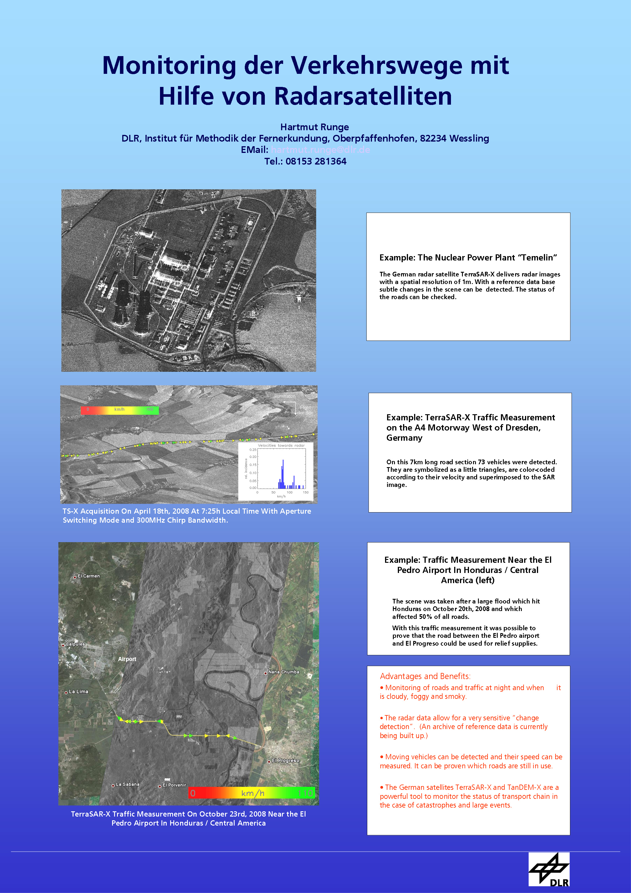 |
| Runge, Hartmut und Balss, Ulrich und Suchandt, Steffen (2015) Hochgenaue Erfassung der Autobahnen für das automatisierte Fahren, das Projekt DriveMark. In: Nationales Forum für Fernerkundung und Copernicus. DLR. Nationales Forum für Fernerkundung und Copernicus 2015, 2015-11-04 - 2015-11-05, Berlin, Germany. Volltext nicht online. |
| Runge, Hartmut und Balss, Ulrich und Suchandt, Steffen und Eineder, Michael (2019) Tectonic Shift Measurement with Geodetic SAR Processing. IEEE. IGARSS 2019, 2019-07-28 - 2019-08-02, Yokohama. doi: 10.1109/igarss.2019.8900059. ISBN 978-1-5386-9154-0. ISSN 2153-7003. | |
| Runge, Hartmut und Balss, Ulrich und Suchandt, Steffen und Klarner, Robert und Cong, Xiaoying (2016) DriveMark – Generation of High Resolution Road Maps with Radar Satellites. In: 11th ITS European Congress, Seiten 1-6. ITS Europe. 11th ITS European Congress, 2016-06-06 - 2016-06-09, Glasgow, Großbritannien. Volltext nicht online. |
| Runge, Hartmut und Balss, Ulrich und Suchandt, Steffen und Krauß, Thomas und Fischer, Peter und Klarner, Robert und Abmayr, Thomas und Wimmer, Michael und Richter, David (2018) Precise Position Capture With Radar Satellites. Munich Satellite Navigation Summit 2018, 2018-03-06 - 2018-03-08, München. Volltext nicht online. |
| Runge, Hartmut und Kurz, Franz und Rosenbaum, Dominik und Reinartz, Peter (2015) Der Einsatz von luftgestützter Photogrammmetrie zur Validierung von Fahrerassistenzsystemen. 7. Tagung Fahrerassistenz, 2015-11-25 - 2015-11-26, München, Deutschland. | |
| Runge, Hartmut und Suchandt, Steffen und Eineder, Michael und Horn, Ralf und Maurer, Thomas (2004) River Run Off Measurement With SAR Along Track Interferometry. In: ESA BIOGEOSAR Conference Proceedings, Seiten 231-238. ESA ESTEC. 4th International Symposium on Retrieval of Bio-Geophysical-Parameters from SAR Data and Land Applications, 2004-11-16 - 2004-11-19, Innsbruck, Austria. | |
| Runge, Hartmut und Suchandt, Steffen und Kotenkov, Alexander und Breit, Helko und Vonavka, Martin und Balss, Ulrich (2007) Space Borne SAR Traffic Monitoring. In: Proceedings of International Radar Symposium 2007, Seiten 1-5. DGON Bonn, Germany. IRS 2007, 2007-09-05 - 2007-09-07, Cologne, Germany. | |
| Sabater, J.M. und Hanssen, Ramon und Kampes, Bert und Fusco, Adele und Adam, Nico (2003) Physical analysis of atmospheric delay signal observed in stacked radar interferometric data. In: Proceedings of the 2003 IEEE International Geoscience and Remote Sensing Symposium, Vol. 3, Seiten 2112-2115. The Institute of Electrical and Electronics. IGARSS 2003, 2003-07-21 - 2003-07-25, Toulouse, Frankreich. ISBN 0-7803-7929-2 . ISSN DOI: 10.1109/IGARSS.2003.1294356 . Volltext nicht online. |
| Sakar, Nida (2015) Development of Advanced Co-registration Methods for Sentinel-1 TOPS Mode. Masterarbeit, Technische Universität München. Volltext nicht online. |
| Sakar, Nida und Brcic, Ramon und Rodriguez Gonzalez, Fernando und Yague-Martinez, Nestor (2015) An Advanced Co-Registration Method for TOPSAR Interferometry. In: 2015 IEEE International Geoscience and Remote Sensing Symposium (IGARSS), Seiten 5240-5243. IEEE Xplore. IGARSS 2015, 2015-07-26 - 2015-07-31, Mailand, Italien. doi: 10.1109/IGARSS.2015.7327016. Volltext nicht online. |
| Sakkas, Vassilis und Adam, Nico Alexander und Papadimitriou, Panagiotis und Voulgaris, Nikolaos und Vassilopoulou, Spyridoula und Damiata, Brian N und Lagios, Evangelos und Stramondo, Salvatore (2013) Combined Ground Deformation Study Of Broader Area Of Patras Gulf (W. Greece) Using PSI-WAP, DGPS And Seismicity Analyses. In: ESA Living Planet Symposium 2013, SP-722. ESA. ESA Living Planet Symposium 2013, 2013-09-09 - 2013-09-13, Edinburgh, United Kingdom. ISBN 9789292212865 [9292212869]. ISSN 1609042X. | |
| Sakkas, Vassilis und Lagios, Evangelos und Vassilopoulou, Spyridoula und Adam, Nico Alexander (2015) Ground Deformation in the Broader Area of the Atalanti Fault Zone (Central Greece) Based on GPS & PSI-WAP. In: Proceedings of IGARSS 2015, Seiten 4676-4679. IEEE Xplore. IGARSS 2015, 2015-07-26 - 2015-07-31, Mailand, Italien. doi: 10.1109/IGARSS.2015.7326872. ISBN ISBN: 978-1-4799-7928-8. | |
| Sansivero, Fabio und Vilardo, G. und Borgstrom, S. und De Martino, P. und Siniscalchi, V. und Minet, Christian und Goel, Kanika (2012) Comparison between temperatures pattern from thermal IR time series analisys and deformational pattern from InSAR and GPS data at Campi Flegrei caldera (Naples, Italy). European Geosciences Union - General Assembly 2012, 2012-04-22 - 2012-04-27, Wien, Österreich. Volltext nicht online. |
| Saporta, Paloma (2020) Spatio-temporal analysis of a short-term systematic phase bias in Synthetic Aperture Radar interferograms over Sicily. Masterarbeit, TUM - DLR. Volltext nicht online. |
| Saporta, Paloma und Gomba, Giorgio und De Zan, Francesco (2021) Analyzing an InSAR short-term systematic phase bias with regards to soil moisture and landcover. European Geosciences Union (EGU) General Assembly, 2021-04-19 - 2021-04-30, online. doi: 10.5194/egusphere-egu21-3503. | |
| Schlaak, Marius und Gisinger, Christoph und Gruber, Thomas (2021) Absolute Positioning of Active Radar Transponders from Sentinel-1 Observations - Experiences and Results. IAG 2021 - Scientific Assembly of the International Association of Geodesy, 2021-06-28 - 2021-07-02, Beijing, China. | |
| Schlund, Michael und von Poncet, Felicitas und Wessel, Birgit und Schweißhelm, Barbara und Kiefl, Nadine (2023) Assessment of TanDEM-X DEM 2020 Data in Temperate and Boreal Forests and Their Application to Canopy Height Change. PFG - Journal of Photogrammetry, Remote Sensing and Geoinformation Science, 91, Seiten 107-123. Springer. doi: 10.1007/s41064-023-00235-1. ISSN 2512-2789. | |
| Schmitt, Michael und Shahzad, Muhammad und Zhu, Xiao Xiang (2015) Reconstruction of Individual Trees from Multi-Aspect TomoSAR Data. Remote Sensing of Environment, 165, Seiten 175-185. Elsevier. doi: 10.1016/j.rse.2015.05.012. ISSN 0034-4257. Volltext nicht online. |
| Schmitt, Michael und Shahzad, Muhammad und Zhu, Xiao Xiang (2016) Forest remote sensing on the individual tree level by airborne millimeterwave SAR. In: Proceedings of 2016 IEEE International Geoscience and Remote Sensing Symposium (IGARSS), Seiten 151-154. IEEE Xplore. IGARSS 2016, 2016-07-10 - 2016-07-15, Peking, China. doi: 10.1109/igarss.2016.7729030. ISBN 978-1-5090-3332-4. | |
| Schmitt, Michael und Tupin, Florence und Zhu, Xiao Xiang (2017) Fusion of SAR and optical remote sensing data - challenges and recent trends. In: Proceedings of IEEE Geoscience and Remote Sensing Symposium, Seiten 5458-5461. IGARSS 2017, 2017-07-23 - 2017-07-28, Fort Worth, USA. doi: 10.1109/IGARSS.2017.8128239. Volltext nicht online. |
| Schmitt, Michael und Wei, Lingyun und Zhu, Xiao Xiang (2015) Automatic Coastline Detection in Non-locally Filtered TanDEM-X Data. In: Proceedings of IEEE International Geoscience and Remote Sensing Symposium (IGARSS) 2015, Seiten 1036-1039. IEEE Xplore. IGARSS 2015, 2015-07-26 - 2015-07-31, Mailand, Italien. doi: 10.1109/igarss.2015.7325946. | |
| Schmitt, Michael und Zhu, Xiao Xiang (2016) Data Fusion and Remote Sensing – An Ever-Growing Relationship. IEEE Geoscience and Remote Sensing Magazine (GRSM), 4 (4), Seiten 6-23. IEEE - Institute of Electrical and Electronics Engineers. doi: 10.1109/MGRS.2016.2561021. ISSN 2168-6831. Volltext nicht online. |
| Schmitt, Michael und Zhu, Xiao Xiang (2016) Demonstration of Single-Pass Millimeterwave SAR Tomography for Forest Volumes. IEEE Geoscience and Remote Sensing Letters, 13 (2), Seiten 202-206. IEEE - Institute of Electrical and Electronics Engineers. doi: 10.1109/LGRS.2015.2506150. ISSN 1545-598X. | |
| Schmitt, Michael und Zhu, Xiao Xiang (2016) Forest Analysis by Single-Pass Millimeterwave SAR Tomography. In: 11th European Conference on Synthetic Aperture Radar, EUSAR 2016, Seiten 40-43. VDE Verlag. EUSAR 2016, 2016-06-06 - 2016-06-09, Hamburg, Germany. ISBN 978-3-8007-4228-8. ISSN 2197-4403. | |
| Schmitt, Michael und Zhu, Xiao Xiang (2016) On the challenges in stereogrammetric fusion of SAR and optical imagery for urban areas. In: ISPRS Annals of the Photogrammetry, Remote Sensing and Spatial Information Sciences, XLI (B7), Seiten 719-722. ISPRS Archive. ISPRS Congress 2016, 2016-07-12 - 2016-07-19, Prag, Tschenchien. doi: 10.5194/isprsarchives-XLI-B7-719-2016. ISSN 2194-9042. | |
| Schmitz, Bernhard und Eis, Christine und Bathmann, Martin und Bahlmann, Jonathan und Büskens, Christof (2025) Optimizing shipping routes based on dynamic ice maps. Arctic Frontiers 2025, 2025-01-27 - 2025-01-30, Tromsø, Norway. Volltext nicht online. |
| Schneemann, Jörge und Hieronimus, Julian und Jacobsen, Sven und Lehner, Susanne und Kühn, Martin (2015) Offshore wind farm flow measured by complementary remote sensing techniques: radar satellite TerraSAR-X and lidar windscanners. In: Journal of Physics: Conference Series, 625 (1), Seiten 1-8. IOP Publishing Ltd. Wake Conference 2015, 2015-06-09 - 2015-06-11, Visby, Sweden. doi: 10.1088/1742-6596/625/1/012015. ISSN 1742-6596. Volltext nicht online. |
| Schnupfhagn, Christoph und Frost, Anja (2026) Sentinel-1 SAR Repeat-Pass Interferometry for Early Indication of Landfast Ice Breakup Sites: A Case Study in the Canadian Arctic. IEEE. EUSAR 2026, 2026-06-08 - 2026-06-11, Baden Baden, Germany. Volltext nicht online. |
| Schnupfhagn, Christoph und Pleskachevsky, Andrey und Tings, Björn (2025) Sea State Retrieval from Sentinel-1 and 10-Year Archive Processing for the ESA Climate Change Initiative (CCI). Sentinel-1 Quality Working Group, 2025-11-18 - 2025-11-20, Frascati, Italy. Volltext nicht online. |
| Schnupfhagn, Christoph und Yang, Yi-Jie (2024) Oil Spill Monitoring in the Gulf of Mexico based on Deep Learning using Spaceborne SAR Imagery from the European Copernicus Mission. AGU24, 2024-12-09 - 2024-12-13, Washington D.C., USA. Volltext nicht online. |
| Schnupfhagn, Christoph und Yang, Yi-Jie (2025) Oil Spill Monitoring in the North Sea Based on Deep Learning Using SAR Imagery. In: ESA Living Planet. ESA Living Planet Symposium, 2025-06-23 - 2025-06-27, Vienna, Austria. Volltext nicht online. |
| Schnupfhagn, Christoph und Yang, Yi-Jie (2025) Automated Deep-Learning Based Oil Spill Detection in the North Sea from Spaceborne SAR. WAW Machine Learning 11, 2025-10-28 - 2025-10-30, Oberpfaffenhofen, Germany. Volltext nicht online. |
| Schulze, Daniel und Diedrich, Erhard und Maurer, Edith und Schulze, Daniel und Bachmann, Markus und Steinbrecher, Ulrich und Zink, Manfred und Kahle, Ralph und Kröger, Sven und Wörle, Maria Theresia und Molch, Katrin und Wolfmüller, Meinhard und Figwer, Florian und Fritz, Thomas und De Zan, Francesco (2016) Tandem-L Ground Segment Phase A Executive Summary. Projektbericht. TDL-MD-RP-0001. 30 S. Volltext nicht online. |
| Schwarz, Gottfried (2012) Data Mining in Germany. ESA-EUSC-JRC 8th Conference on Image Information Mining, 2012-10-24 - 2012-10-26, Oberpfaffenhofen, germany. Volltext nicht online. |
| Schwarz, Gottfried und Espinoza-Molina, Daniela und Breit, Helko und Datcu, Mihai (2008) Optimized Multilooking for Robust SAR Image Indexing. In: Proc. IGARSS 2008, Seiten 86-89. IEEE. IGARSS 2008, 2008-07-06 - 2008-07-11, Boston, Mass.. Volltext nicht online. |
| Schwarz, Egbert und Krause, Detmar und Voinov, Sergey und Daedelow, Holger und Jacobsen, Sven und Tings, Björn (2016) Research and pre-operational application of near real time services for maritime situational awareness. TerraSAR-X/TanDEM-X Science Team Meeting 2016, 2016-10-17 - 2016-10-20, Oberpfaffenhofen, Deutschland. | |
| Schwarz, Egbert und Krause, Detmar und Voinov, Sergey und Daedelow, Holger und Lehner, Susanne (2016) Near Real Time Applications for Maritime Situational Awareness. Fourth International Conference on Remote Sensing and Geoinformation of Environment (RSCY2016), 2016-04-04 - 2016-04-08, Paphos, Cyprus. | |
| Schwarz, Egbert und Krause, Detmar und Voinov, Sergey und Daedelow, Holger und Tings, Björn und Pleskachevsky, Andrey und Singha, Suman und Jacobsen, Sven (2017) Applications for Maritime Situational Awareness. C-SIGMA VII, 2017-04-19 - 2017-04-20, Lissabon. | |
| Schwarz, Egbert und Voinov, Sergey und Frauenberger, Olaf und Krause, Detmar und Tings, Björn (2018) Remote Sensing Analysis Framework for Maritime Surveillance Application. In: CMRE Maritime Big Data Workshop, Seiten 1-6. Maritime Big Data Workshop CMRE, 2018-05-09 - 2018-05-10, LaSpezia, Italien. Volltext nicht frei. | |
| Schwarz, Egbert und Voinov, Sergey und Krause, Detmar und Daedelow, H. und Tings, Björn (2017) Applications for Maritime Situational Awareness. Asian Space Technology Summit, 2017, Kuala Lumpur, Malaysia. | |
| Schweißhelm, Barbara und Lachaise, Marie (2022) Calibration of the TANDEM-X CRaw DEMs for the TANDEM-X DEM Change Maps Generation. In: International Geoscience and Remote Sensing Symposium (IGARSS), Seiten 291-294. IGARSS 2022, 2022-07-18 - 2022-07-22, Kuala Lumpur, Malaysia. doi: 10.1109/IGARSS46834.2022.9883204. | |
| Schweißhelm, Barbara und Lachaise, Marie (2023) TanDEM-X DEM Change Maps Stacks: Towards TanDEM-X 4D. In: International Geoscience and Remote Sensing Symposium (IGARSS), Seiten 1329-1332. IGARSS 2023, 2023-07-16 - 2023-07-21, Pasadena, USA. doi: 10.1109/IGARSS52108.2023.10282397. | |
| Schweißhelm, Barbara und Lachaise, Marie (2023) Towards TanDEM-X 4D With DEM Change Map Stacks Over Glaciers and Ice Fields. FRINGE 2023, 2023-09-11 - 2023-09-15, Leeds, United Kingdom. Volltext nicht online. |
| Schweißhelm, Barbara und Lachaise, Marie (2023) Stacks of TanDEM-X DEM Change Maps - Towards a 4D TanDEM-X DEM. TerraSAR-X/TanDEM-X Science Team Meeting, 2023-10-18 - 2023-10-20, Oberpfaffenhofen, Deutschland. Volltext nicht online. |
| Schweißhelm, Barbara und Lachaise, Marie und Fritz, Thomas (2020) An Adaptive Filtering Approach for the New TanDEM-X Change DEM. In: 2020 IEEE International Geoscience and Remote Sensing Symposium, IGARSS 2020, Seiten 1-4. IGARSS 2020, 2020-09-26 - 2020-10-02, online. doi: 10.1109/igarss39084.2020.9323369. ISBN 978-172816374-1. ISSN 2153-6996. Volltext nicht frei. | |
| Schweißhelm, Barbara und Lachaise, Marie und Fritz, Thomas (2021) Change Detection within the Processing of the TanDEM-X Change DEM. In: International Geoscience and Remote Sensing Symposium (IGARSS), Seiten 2130-2133. IGARSS 2021, 2021-07-11 - 2021-07-16, Brussels, Belgium - virtual. doi: 10.1109/IGARSS47720.2021.9554010. | |
| Schättler, Birgit und Breit, Helko und Fritz, Thomas und Schwarz, Egbert und Damerow, Heiko und Balss, Ulrich und Boerner, Elke und Balzer, Wolfgang (2006) The TerraSAR-X Payload Ground Segment: Pre-Launch Status and Performance. CEOS SAR Calibration and Validation Workshop , 2006-10-06, Edinburgh, Great Britain. | |
| Schättler, Birgit und Kahle, Ralph und Metzig, Robert und Steinbrecher, Ulrich und Zink, Manfred (2011) The Joint TerraSAR-X / TanDEM-X Ground Segment. In: Proceedings of Geoscience and Remote Sensing Symposium (IGARSS), Seiten 2298-2301. IEEE International. IGARSS 2011, 2011-07-24 - 2011-07-29, Vancouver, Kanada. doi: 10.1109/igarss.2011.6049668. ISBN 978-1-4577-1003-2. ISSN 2153-6996. Volltext nicht online. |
| Schättler, Birgit und Fritz, Thomas und Breit, Helko und Adam, Nico Alexander und Balss, Ulrich und Lachaise, Marie und Eineder, Michael und Niedermeier, Andreas (2008) TerraSAR-X SAR Data Processing: Results from Commissioning and Early Operational Phase. In: Remote Sensing - New Challenges of High Resolution: Proceedings of EARSeL Joint Workshop 2008 Bochum (Germany), Seiten 226-241. Selbstverlag des Geographischen Instituts der Ruhr-Universität Bochum. Remote Sensing - New Challenges of High Resolution - EARSel Joint Workshop 2008, 2008-03-05 - 2008-03-07, Bochum, Germany. ISBN ISBN 978-3-925143-79-3. | |
| Schättler, Birgit und Fritz, Thomas und Breit, Helko und Eineder, Michael und Adam, Nico Alexander und Schwarz, Egbert und Damerow, Heiko und Reissig, Ralf und Huber, Martin und Balzer, Wolfgang und Balss, Ulrich und Lachaise, Marie und Niedermeier, Andreas (2007) TerraSAR-X Payload Data Processing - A Commissioning Phase Perspective. In: ASAR 2007 Proceedings CD-Rom. Advanced SAR Workshop 2007, 2007-09-11 - 2007-09-13, Vancouver, Canada. Volltext nicht online. |
| Schättler, Birgit und Kahle, Ralph und Steinbrecher, Ulrich und Metzig, Robert und Balzer, Wolfgang und Zink, Manfred (2010) Extending the TerraSAR-X Ground Segment for TanDEM-X. In: Proceedings of 8th EUSAR 2010, Seiten 1-4. VDE Verlag. 8th EUSAR 2010, 2010-06-07 - 2010-06-10, Aachen, Deutschland. ISBN 978-3-8007-3272-2. | |
| Schättler, Birgit und Mrowka, Falk und Schwarz, Egbert und Lachaise, Marie (2016) The TerraSAR-X Ground Segment in service for nine years: current status and recent extensions. In: International Geoscience and Remote Sensing Symposium (IGARSS), Seiten 1400-1403. IEEE Xplore. IGARSS 2016, 2016-07-10 - 2016-07-15, Beijing, China. doi: 10.1109/IGARSS.2016.7729358. ISSN 2153-7003. Volltext nicht online. |
| Schättler, Birgit und Schwarz, Egbert und Mrowka, Falk und Fritz, Thomas (2015) Serving the TerraSAR-X Mission For Over Eight Years: Current Status and Recent Extensions of the TerraSAR-X Ground Segment. 10th Advanced SAR Workshop 2015, 2015-10-20 - 2015-10-22, Montreal, Kanada. | |
| Schättler, Birgit und Schwarz, Egbert und Mrowka, Falk und Fritz, Thomas (2015) Serving the TerraSAR-X Mission For Over Eight Years: Current Status and Recent Extensions of the TerraSAR-X Ground Segment. In: Advanced SAR Workshop Presentations on Canadian Space Agency FTP Server. Canadian Space Agency. 10th Advanced SAR Workshop 2015, 2015-10-20 - 2015-10-22, Montreal, Kanada. | |
| Sdralia, Vasiliki (2020) Precise Geodetic Positioning of Corner Reflectors and SAR ECR-C with Sentinel-1. Masterarbeit, Technische Universität München. Volltext nicht frei. | |
| Selley, Heather und Hogg, Anna und Cornford, Stephen und Dutrieux, Pierre und Shepherd, Andrew und Wuite, Jan und Floricioiu, Dana und Kusk, Anders und Nagler, Thomas und Gilbert, Lin und Slater, Thomas und Kim, Tae-Wan (2021) Widespread increase in dynamic imbalance in the Getz region of Antarctica from 1994 to 2018. Nature Communications, 12 (1133), Seiten 1-10. Nature Publishing Group. doi: 10.1038/s41467-021-21321-1. ISSN 2041-1723. | |
| Semakova, Eleonora und Floricioiu, Dana und Bühler, Yves und Manconi, Andrea und Potorjinskiy, Mikhail und Krieger, Lukas und Semakov, Dmitriy und Khatamova, Nilufar (2025) Satellite data synergy for analysis of the glacier daily lowering rate in the Pskem River basin, Uzbekistan. International Mountain Conference, 2025-09-14 - 2025-09-18, Innsbruck, Austria. | |
| Semakova, Eleonora und Floricioiu, Dana und Wendt, Anja und Bühler, Yves und Ramanath Tarekere, Sindhu (2023) Glacier and snow avalanche studies in Uzbekistan based on TanDEM-X, TerraSAR-X and PAZ SAR data. In: IUGG 28th General Assembly. IUGG 28th General Assembly, 2023-07-11 - 2023-07-20, Berlin, Deutschland. Volltext nicht online. |
| Shahzad, Muhammad und Schmitt, Michael und Zhu, Xiao Xiang (2015) Segmentation and crown parameter extraction of indiviudal trees in an airborne TomoSAR point cloud. In: The International Archives of the Photogrammetry, Remote Sensing and Spatial Information Sciences, XL-3/W, Seiten 205-209. Copernicus Publications. PIA15+HRIGI15 – Joint ISPRS conference, 2015-03-25 - 2015-03-27, Munich, Germany. doi: 10.5194/isprsarchives-XL-3-W2-205-2015. | |
| Shahzad, Muhammad und Zhu, Xiao Xiang (2013) Building façades reconstruction using multi-view TomoSAR point clouds. In: Proceedings of Joint Urban Remote Sensing Event, Seiten 163-166. JURSE 2013, 2013-04-21 - 2013-04-23, Sao Paolo, Brazil. doi: 10.1109/JURSE.2013.6550691. ISBN 978-1-4799-0212-5. Volltext nicht online. |
| Shahzad, Muhammad und Zhu, Xiao Xiang (2013) Reconstruction of building façades using spaceborne multiview TomoSAR point clouds. In: Proceedings of IGARSS 2013, Seiten 1-4. IEEE Xplore. IGARSS 2013, 2013-07-21 - 2013-07-26, Melbourne, Australia. doi: 10.1109/igarss.2013.6721234. | |
| Shahzad, Muhammad und Zhu, Xiao Xiang (2013) Robust Building Facade Reconstruction from Spaceborne Tomosar Points. In: ISPRS Annals of the Photogrammetry, Remote Sensing and Spatial Information Sciences, II-3/W, Seiten 85-90. Copernicus GmbH (Copernicus Publications) on behalf of the ISPRS. CMRT13 – City Models, Roads and Traffic 2013, 2013-11-12 - 2013-11-13, Antalya, Turkey. doi: 10.5194/isprsannals-II-3-W3-85-2013. ISSN 2194-9042. | |
| Shahzad, Muhammad und Zhu, Xiao Xiang (2015) Robust Reconstruction of Building Façades for Large Areas Using Spaceborne TomoSAR Point Clouds. IEEE Transactions on Geoscience and Remote Sensing, 53 (2), Seiten 752-769. IEEE - Institute of Electrical and Electronics Engineers. doi: 10.1109/TGRS.2014.2327391. ISSN 0196-2892. | |
| Shahzad, Muhammad und Zhu, Xiao Xiang (2014) Reconstructing 2-D/3-D Building Shapes From Spaceborne Tomographic SAR Point Clouds. In: 3rd ISPRS Commission Symposium on Photogrammetric Computer Vision (ISSN: 0031-868X), XL-3, Seiten 313-320. ISPRS. Photogrammetric Computer Vision PCV 2014, 2014-09-05 - 2014-09-07, Zurich, Switzerland. doi: 10.5194/isprsarchives-XL-3-313-2014. ISSN 0031-868X. | |
| Shahzad, Muhammad und Zhu, Xiao Xiang (2014) Automatic large area reconstruction of building façades from spaceborne TomoSAR point clouds. IGARSS 2014, 2014-07-13 - 2014-07-18, Quebec, Canada. doi: 10.1109/IGARSS.2014.6946734. | |
| Shahzad, Muhammad und Zhu, Xiao Xiang (2015) Detection of Buildings in Spaceborne TomoSAR Point Clouds via Hybrid Region Growing and Energy Minimization Technique. In: Urban Remote Sensing Event (JURSE), 2015 Joint, Seiten 1-4. IEEE Xplore. JURSE 2015, 2015-03-30 - 2015-04-01, Lausanne, Switzerland. doi: 10.1109/JURSE.2015.7120480. | |
| Shahzad, Muhammad und Zhu, Xiao Xiang (2015) Reconstruction of Building Footprints using Spaceborne TOMOSAR Point Clouds. In: ISPRS Annals of the Photogrammetry, Remote Sensing and Spatial Information Sciences, Seiten 385-392. CMRT 2015, 2015-10-01 - 2015-10-02, La Motte, France. doi: 10.5194/isprsannals-II-3-W5-385-2015. ISSN 2194-9042. | |
| Shahzad, Muhammad und Zhu, Xiao Xiang (2016) Automatic detection and reconstruction of 2D/3D building shapes from spaceborne TomoSAR point clouds. IEEE Transactions on Geoscience and Remote Sensing, 54 (3), Seiten 1292-1310. IEEE - Institute of Electrical and Electronics Engineers. doi: 10.1109/TGRS.2015.2477429. ISSN 0196-2892. | |
| Shahzad, Muhammad und Zhu, Xiao Xiang und Bamler, Richard (2012) Façade structure reconstruction using spaceborne TomoSAR point clouds. In: International Geoscience and Remote Sensing Symposium (IGARSS), Seiten 467-470. IGARSS'12, 2012-07-22 - 2012-07-27, Munich, Germany. doi: 10.1109/igarss.2012.6351385. | |
| Shao, Weizeng und Li, Xiao-Ming und Lehner, Susanne und Guan, Changlong (2014) Development of polarization ratio model for sea surface wind field retrieval from TerraSAR-X HH polarization data. International Journal of Remote Sensing, 35 (11-12), Seiten 4046-4063. Taylor & Francis. doi: 10.1080/01431161.2014.916059. ISSN 0143-1161. Volltext nicht online. |
| Shi, Yilei und Zhu, Xiao Xiang und Ellero, Marco und Adams, Nikolaus A. (2013) Analysis of interpolation schemes for the accurate estimation of energy spectrum in Lagrangian methods. Computers & Fluids, 82 (8), Seiten 122-131. Elsevier. doi: 10.1016/j.compfluid.2013.05.003. ISSN 0045-7930. Volltext nicht online. |
| Shi, Yilei (2019) Large-Scale 3-D Urban Mapping by Fusing InSAR and Optical Data. Dissertation, TU München. | |
| Shi, Yilei und Wang, Yuanyuan und Kang, Jian und Lachaise, Marie und Zhu, Xiao Xiang und Bamler, Richard (2018) 3D reconstruction from very small TanDEM-X stacks. In: Proceedings of the European Conference on Synthetic Aperture Radar, EUSAR, Seiten 257-260. EUSAR 2018, 2018-06-04 - 2018-06-07, Aachen, Germany. Volltext nicht frei. | |
| Shi, Yilei und Zhu, Xiao Xiang und Bamler, Richard (2015) Optimized parallelization of non-local means filter for image noise reduction of InSAR image. In: 2015 IEEE International Conference on Information and Automation, ICIA 2015 - In conjunction with 2015 IEEE International Conference on Automation and Logistics, Seiten 1515-1518. IEEE. 2015 IEEE International Conference on Information and Automation, 2015-08-08 - 2015-08-10, Lijiang, China. doi: 10.1109/ICInfA.2015.7279525. ISBN 978-1-4673-9104-7. Volltext nicht frei. | |
| Siegmund, Robert und Brcic, Ramon und Kotzerke, Paul und Eineder, Michael (2022) The European Ground Motion Service EGMS - Processing Central Europe with First Results on Quality and Point Densities. In: International Geoscience and Remote Sensing Symposium (IGARSS), Seiten 5105-5108. IEEE. IGARSS 2022, 2022-07-17 - 2022-07-22, Kuala Lumpur, Malaysia. doi: 10.1109/IGARSS46834.2022.9883234. Volltext nicht online. |
| Singha, Suman (2014) Offshore Oil Spill Detektion using Synthetic Aperture Radar. Dissertation, University of Hull, UK. Volltext nicht online. |
| Singha, Suman (2017) Evaluation of polarimetric features for sea ice characterization at X, C and L- band SAR. In: 2017 IEEE International Geoscience and Remote Sensing Symposium (IGARSS), Seiten 338-341. IEEE Xplore. IGARSS 2017, 2017-07-23 - 2017-07-28, Fort Worth, Texas, USA. doi: 10.1109/IGARSS.2017.8126965. ISSN 2153-7003. | |
| Singha, Suman (2017) Arctic Sea Ice Characterization Using Fully Polarimetric Air-Borne and Space-Borne Synthetic Aperture Radar. CIRFA Seminar, 2017-03-02, Tromsö, Norway. Volltext nicht online. |
| Singha, Suman (2017) Arctic Sea Ice Characterization Using Fully Polarimetric Air-Borne and Space-Borne Synthetic Aperture Radar. Environment and Climate Change in Canada, 2017-06-16, Montréal, Canada. Volltext nicht online. |
| Singha, Suman (2017) Comparison of Compact Polarimetric (RISAT-1) and Fully polarimetric (RADARSAT-2) SAR Acquisitions for Sea Ice Characterization. The 18th Meeting of the IICWG (IICWG-XVIII) - New technologies, big data, and the future of ice charting and forecasting, 2017-09-25 - 2017-09-29, Hobart, Australia. Volltext nicht online. |
| Singha, Suman (2018) Potential of compact polarimetry for operational sea ice monitoring over Arctic and Antarctic Region. In: 2018 International Geoscience and Remote Sensing Symposium (IGARSS), Seiten 7113-7116. IEEE. IGARSS 2018, 2018-07-23 - 2018-07-27, Valencia, Spain. doi: 10.1109/IGARSS.2018.8517653. | |
| Singha, Suman (2018) Near Real Time High Resolution SAR Based Sea Ice Information for Polar Navigation. 19th Meeting of the International Ice Charting Working Group - IICWG, 2018-09-24 - 2018-09-28, Helsinki, Finland. Volltext nicht online. |
| Singha, Suman (2018) Operational Synthetic Aperture Radar Based Sea Ice Classification. 15th International Circumpolar Remote Sensing Symposium, 2018-09-10 - 2018-09-14, Potsdam, Germany. | |
| Singha, Suman (2021) Towards Pan-Arctic Sea Ice Type Retrieval using Sentinel-1 TOPSAR modes. In: 13th European Conference on Synthetic Aperture Radar, EUSAR 2021, Seiten 1-3. IEEE. EUSAR 2021, 2021-03-29 - 2021-04-01, online. ISBN 978-380075457-1. ISSN 2197-4403. | |
| Singha, Suman (2021) Oceanography. Remote Sensing (Lecture), 2021-03-02, Victoria, Kanada - online. Volltext nicht online. |
| Singha, Suman und Dabboor, Mohammed und Montpetit, Benoit und Jacobsen, Sven (2017) Sea Ice Characterization Using Simulated Compact Polarimetric (RCM) and Compact Polarimetric (RISAT-1) SAR Data. Earth Observation Summit 2017, 2017-06-20 - 2017-06-22, Montréal, Canada. Volltext nicht online. |
| Singha, Suman und Frost, Anja und Jacobsen, Sven und Schwarz, Egbert (2018) Synthetic Aperture Based Sea Ice Products for MOSAiC. MOSAiC Science Workshop, 2018-05-28 - 2018-06-01, Potsdam, Germany. | |
| Singha, Suman und Imber, James (2019) Synthetic Aperture Radar based Sea Ice Type Retrieval using Deep Neural Network. In: Proceedings of Living Planet Symposium 2019. ESA Living Planet Symposium, 2019-05-13 - 2019-05-17, Mailand, Italien. | |
| Singha, Suman und Imber, James und Kortum, Karl und Günzel, Dominik (2022) Can operational Ice Charts help to train AI for Sea Ice properties retrieval? In: ESA Living Planet. ESA Living Planet Symposium, 2022-05-23 - 2022-05-27, Bonn, Germany. | |
| Singha, Suman und Johansson, A. Malin und Doulgeris, Anthony P. (2019) Towards operational sea ice type retrieval using L-Band Synthetic Aperture Radar. In: 2019 International Geoscience and Remote Sensing Symposium (IGARSS), Seiten 4226-4229. IEEE. IGARSS 2019, 2019-07-28 - 2019-08-02, Yokohama, Japan. doi: 10.1109/IGARSS.2019.8900458. | |
| Singha, Suman und Johansson, A. Malin und Doulgeris, Anthony P. (2021) Robustness of SAR Sea Ice Type Classification across Incidence Angles and Seasons at L-band. IEEE Transactions on Geoscience and Remote Sensing, 59 (12), Seiten 9941-9952. IEEE - Institute of Electrical and Electronics Engineers. doi: 10.1109/TGRS.2020.3035029. ISSN 0196-2892. | |
| Singha, Suman und Johansson, A. Malin und Hughes, Nicholas und Hvidegaard, Sine M. und Skourup, Henriette (2018) Arctic Sea Ice Characterization using Spaceborne Fully Polarimetric L-, C- and X-Band SAR with Validation by Airborne Measurements. IEEE Transactions on Geoscience and Remote Sensing, 56 (7), Seiten 3715-3734. IEEE - Institute of Electrical and Electronics Engineers. doi: 10.1109/TGRS.2018.2809504. ISSN 0196-2892. | |
| Singha, Suman und Johansson, A. Malin und Hughes, Nicholas und Hvidegaard, Sine M. und Skourup, Henriette (2018) Arctic Sea Ice Characterization for Navigational Assistance using Space-borne Fully Polarimetric SAR. In: Arctic Frontiers Science 2018 – Abstracts. Tromsø, Norway. Artic Frontiers 2018, 2018-01-21 - 2018-01-26, Tromsø, Norway. ISBN 978‐82‐690420‐2‐3. Volltext nicht online. |
| Singha, Suman und Johansson, A. Malin und Hughes, Nicholas und Hvidegaard, Sine M. und Skourup, Henriette (2018) High Resolution Sea Ice Observation using Space-borne Fully Polarimetric SAR. In: Abstract Proceedings POLAR 2018, Seite 1110. POLAR 2018, 2018-06-15 - 2018-06-26, Davos, Switzerland. ISBN 978-0-948277-54-2. | |
| Singha, Suman und Johansson, Malin und Doulgeris, Anthony P. (2019) Arctic Sea Ice Classification Using ALOS-2 PALSAR-2 L-Band SAR Images. In: Proceedings of Living Planet Symposium 2019. ESA Living Planet Symposium, 2019-05-13 - 2019-05-17, Mailand, Italien. | |
| Singha, Suman und Johansson, Malin und Spreen, Gunnar und Howell, Stephen und Sobue, Shinichi und Davidson, Malcolm (2021) Year-Around C- and L- Band Observation Around The MOSAiC Ice Floe With High Spatial and Temporal Resolution. In: International Geoscience and Remote Sensing Symposium (IGARSS), Seiten 5509-5512. IEEE. IGARSS 2021, 2021-07-11 - 2021-07-16, Brussel, Belgium - virtual. doi: 10.1109/IGARSS47720.2021.9553062. | |
| Singha, Suman und Jäger, Marc (2017) Arctic Sea Ice Characterization using Multi-frequency Fully Polarimetric Airborne DLR-FSAR system. ESA POLinSAR Workshop, 2017-01-23 - 2017-01-27, Frascati, Italy. Volltext nicht online. |
| Singha, Suman und Jäger, Marc (2018) Characterization of Arctic Sea Ice using L, S and X-Band Fully Polarimetric Airborne F-SAR System. In: Proceedings of the European Conference on Synthetic Aperture Radar, EUSAR, Seiten 441-445. VDE Verlag GmbH, Berlin, Offenbach. European Conference on Synthetic Aperture Radar (EUSAR), 2018-06-04 - 2018-06-07, Aachen, Germany. ISBN 978-3-8007-4636-1. ISSN 2197-4403. | |
| Singha, Suman und Jäger, Marc (2019) Arctic Sea Ice Classification and Validation using Multi Frequency Fully Polarimetric and Interferometric Airborne F-SAR System. International Glaciological Society Sea Ice Symposium, 2019-08-18 - 2019-08-23, Winnipeg, Canada. | |
| Singha, Suman und Ressel, Rudolf (2016) Operational Sea Ice Monitoring using Fully Polarimetric X, C and L- band space-borne SAR data. HGF-EDA Alliance Week, 2016-06-27 - 2016-07-01, Garmisch Partenkirchen, Germany. Volltext nicht online. |
| Singha, Suman und Ressel, Rudolf (2016) Offshore Oil Spill Charectarization using Space-Borne Fully Polarimetric X and C Band Synthetic Aperture Radar. TerraSAR-X/TanDEM-X Science Team Meeting, 2016-10-17 - 2016-10-20, DLR Oberpfaffenhofen, Germany. | |
| Singha, Suman und Ressel, Rudolf (2016) Arctic Sea Ice Monitoring using Multisensor SAR Parameters. 17th Meeting of the International Ice Charting Working Group Meeting of the IICWG, 2016-10-24 - 2016-10-28, Ottawa, Canada. Volltext nicht online. |
| Singha, Suman und Ressel, Rudolf (2016) Offshore platform sourced pollution monitoring using space-borne fully polarimetric C and X band synthetic aperture radar. Marine Pollution Bulletin, 112, 327 -340. Elsevier. doi: 10.1016/j.marpolbul.2016.07.044. ISSN 0025-326X. | |
| Singha, Suman und Ressel, Rudolf (2017) Arctic Sea Ice Characterization using RISAT-1 Compact-Pol SAR Imagery and Feature Evaluation: A Case Study Over North-East Greenland. IEEE Journal of Selected Topics in Applied Earth Observations and Remote Sensing, 10 (8), Seiten 3504-3514. IEEE - Institute of Electrical and Electronics Engineers. doi: 10.1109/JSTARS.2017.2691258. ISSN 1939-1404. | |
| Singha, Suman und Ressel, Rudolf und Lehner, Susanne (2015) Offshore Platform Monitoring using Polarimetric TerraSAR-X and RADARSAT-2 Imagery: A Near Real Time Perspective. 10th ASAR Workshop, 2015-10-20 - 2015-10-22, Quebec, Kanada. Volltext nicht online. |
| Singha, Suman und Ressel, Rudolf und Lehner, Susanne (2016) Offshore pollution monitoring using fully-polarimetric X- and C-band synthetic aperture radar: a near-real-time perspective. In: Proc. SPIE, Remote Sensing of the Oceans and Inland Waters: Techniques, Applications, and Challenges, 9878, Seiten 1-13. SPIE Asia-Pacific Remote Sensing Symposium, 2016-04-04 - 2016-04-07, New Delhi, India. doi: 10.1117/12.2223436. Volltext nicht online. |
| Singha, Suman und Ressel, Rudolf und Lehner, Susanne (2016) Multi-Frequency and Multi-Polarization Analysis of Oil Slicks using TerraSAR-X and RADARSAT-2 Data. In: Geoscience and Remote Sensing Symposium (IGARSS), 2016 IEEE International, Seiten 4035-4038. IEEE Xplore. IGARSS 2016, 2016-07-10 - 2016-07-15, Peking, China. doi: 10.1109/IGARSS.2016.7730049. ISBN 978-1-5090-3332-4. ISSN 2153-7003. | |
| Singha, Suman und Ressel, Rudolf und Lehner, Susanne (2016) Investigations into the X and C band Quad-Pol features for oil slick characterization. In: 11th European Conference on Synthetic Aperture Radar Electronic Proceedings, 06 - 09 June, 2016, Hamburg, Germany, Seiten 583-586. VDE Verlag GmbH. EUSAR 2016, 2016-06-06 - 2016-06-09, Hamburg, Germany. ISBN 978-3-8007-4228-8. ISSN 2197-4403. | |
| Singha, Suman und Ressel, Rudolf und Lehner, Susanne (2016) Oil Spill Detection and Characterization using Fully-Polarimetric X and C band SAR Imagery: A Near Real Time Perspective. In: Proceedings of Living Planet Symposium 2016, SP-740, Seiten 1-5. ESA Living Planet Symposium, 2016-05-09 - 2016-05-13, Prague, Czech Republic. ISBN 978-92-9221-305-3. ISSN 1609-042X. Volltext nicht online. |
| Singha, Suman und Ressel, Rudolf und Velotto, Domenico und Lehner, Susanne (2016) A Combination of Traditional and Polarimetric Features for Oil Spill Detection using TerraSAR-X. IEEE Journal of Selected Topics in Applied Earth Observations and Remote Sensing, 9 (11), Seiten 4979-4990. IEEE - Institute of Electrical and Electronics Engineers. doi: 10.1109/JSTARS.2016.2559946. ISSN 1939-1404. | |
| Singha, Suman und Spreen, Gunnar (2019) Coordinating Airborne and Satellite-borne sea ice measurements during MOSAiC. Workshop on Airborne Activities in the Arctic: Science and Prospects, 2019-06-03 - 2019-06-05, Bremen, Germany. Volltext nicht online. |
| Singha, Suman und Spreen, Gunnar und Krumpen, Thomas (2020) MOSAiC: World’s largest drift campaign -Remote Sensing activities. SIOS's online conference on EO and RS applications in Svalbard, 2020-06-04 - 2020-06-05, Longyearbyen, Norway. Volltext nicht online. |
| Singha, Suman und Spreen, Gunnar und Krumpen, Thomas und Davidson, Malcolm und Sobue, Shinichi und Howell, Stephen und Kwok, Ron und Zecchetto, Stefano und Gonzáles Bonilla, María José und Frulla, Laura und Kim, Hyun-Cheol und Toyota, Takenobu und Battagliere, Maria Libera und Schwarz, Egbert (2020) Year-round Satellite Multi Frequency Synthetic Aperture Radar Observations During the MOSAiC Expedition. AGU Fall Meeting, 2020-12-01 - 2020-12-17, Online. Volltext nicht online. |
| Singha, Suman und Topouzelis, Konstantinos und Vespe, Michele und Trieschmann, Olaf (2013) Radiometric normalization on SAR images for oil spill detection. In: Proceedings of ESA Living Planet Symposium 2013. ESA Communications, ESTEC, PO Box 299, 2200 AG Noordwijk, The Netherlands. ESA Living Planet Symposium 2013, 2013-09-09 - 2013-09-13, Edinburgh, UK. ISBN 978 92 9221 286 5. ISSN 1609-042X. Volltext nicht online. |
| Singha, Suman und Velotto, Domenico und Lehner, Susanne (2014) Near real time monitoring of platform sourced pollution using TerraSAR-X over the North Sea. Marine Pollution Bulletin, 86 (1-2), Seiten 379-390. Elsevier. doi: 10.1016/j.marpolbul.2014.06.041. ISSN 0025-326X. Volltext nicht frei. | |
| Singha, Suman und Velotto, Domenico und Lehner, Susanne (2014) Near real time operational oil spill detection service using a classification tree. In: Proceedings of IEEE GOLD Remote Sensing Conference, June 2014, Berlin, Germany, Seiten 1-3. IEEE GOLD Remote Sensing Conference, 2014-06-04 - 2014-06-05, Berlin, Germany. Volltext nicht online. |
| Singha, Suman und Velotto, Domenico und Lehner, Susanne (2015) Towards operational near real time oil spill detection service using polarimetric TerraSAR-X images. In: Proceedings of the POLINSAR 2015, SP-729, Seiten 1-6. ESA Communications. ESA PolinSAR 2015, 2015-01-26 - 2015-01-30, Frascati, Italien. ISBN 978-92-9221-293-3. ISSN 1609-042X. Volltext nicht online. |
| Singha, Suman und Velotto, Domenico und Lehner, Susanne (2015) Dual-Polarimetric Feature Extraction and Evaluation for Oil Spill Detection: A Near Real Time Perspective. In: Proceedings of IEEE International Geoscience and Remote Sensing Symposium (IGARSS) 2015, Seiten 3235-3238. IEEE Xplore. IEEE International Geoscience and Remote Sensing Symposium (IGARSS) 2015, 2015-07-26 - 2015-07-31, Milan, Italy. doi: 10.1109/IGARSS.2015.7326507. ISBN 978-1-4799-7929-5. Volltext nicht online. |
| Singha, Suman und Velotto, Domenico und Lehner, Susanne (2015) Towards operational near real time oil spill detection service using polarimetric TerraSAR-X Images. The Ocean Surface Microlayer and Biogeochemical Feedbacks in the Earth System, 2015-07-01 - 2015-07-03, Kiel. Volltext nicht online. |
| Solari, Lorenzo und Crosetto, Michele und Balasis-Levinsen, Joanna und Bateson, Luke und Casagli, Nicola und Comerci, Valerio und Guerrieri, Luca und Frei, Michaela und Mróz, Marek und Moldestad, Dag Anders und Oyen, Anneleen und Costantini, Mario und Minati, Federico und Trillo, Francesco und Proietti, Sergio und Ferretti, Alessandro und Passera, Emanuele und Dehls, John und Larsen, Yngvar und Marinkovic, Petar und Eineder, Michael und Brcic, Ramon und Siegmund, Robert und Kotzerke, Paul und Kenyeres, Ambrus und Andersen, Henrik S. (2022) First look at the European Ground Motion Service products. Living Planet Symposium 2022, 2022-05-23 - 2022-05-27, Bonn, Germany. Volltext nicht online. |
| Stammler, Melanie und Afonso, Tiago und Cziudai-Sonntag, Felix und Hiller, Johannes und Brcic, Ramon und Dörr, Nils und Fricke, Katharina und Kalia, Andre C. und Navarro Sánchez, Víctor Diego und Preussler, Vreni und Zimmermann, Florian (2025) BBD-V: A national, transport-focused ground motion monitoring service in Germany. In: SMAR 2026, 8th International Conference on Smart Monitoring, Assessment and Rehabilitation of Civil Structures. SMAR 2026, 8th International Conference on Smart Monitoring, Assessment and Rehabilitation of Civil Structures, 2026-08-26 - 2026-08-28, Dresden, Germany. Volltext nicht online. |
| Stammler, Melanie und Afonso, Tiago und Cziudai‑Sonntag, Felix und Hiller, Johannes und Brcic, Ramon und Dörr, Nils und Fricke, Katharina und Kalia, Andre C. und Navarro Sánchez, Víctor Diego und Preußler, Vreni und Zimmermann, Florian (2025) Der BBD-V: Verkehrsspezifisches Bodenbewegungsmonitoring mittels Sentinel-1. In: Nationales Forum für Fernerkundung und Copernicus 2026. Nationales Forum für Fernerkundung und Copernicus 2026, 2026-04-28 - 2026-04-30, Darmstadt, Deutschland. Volltext nicht online. |
| Steinbrecher, Ulrich Erich und Baumgartner , Stefan und Mittermayer, Josef und Wollstadt, Steffen und Suchandt, Steffen und Breit, Helko und Scheiber, Rolf und Schulze, Daniel (2011) Experimental Radar-Modes with TerraSAR-X und TanDEM-X. 20 Years Antarctic Research Station GARS O'Higgins, 2011-11-12 - 2011-11-15, Punta Arenas, Chile. | |
| Suchandt, Steffen und Romeiser, Roland und Runge, Hartmut und Lawrence, John und Steinbrecher, Ulrich (2011) Tidal Current Measurement Using the TanDEM-X Satellite Formation. In: Proceedings of 9th EWTEC 2011, Seiten 1-8. 9th European Wave and Tidal Energy Conference 2011, 2011-09-05 - 2011-09-09, Southampton, England. Volltext nicht frei. | |
| Suchandt, Steffen und Runge, Hartmut und Breit, Helko und Kotenkov, Alexander und Weihing, Diana und Hinz, Stefan (2008) Traffic Measurement with TerraSAR-X: Processing System Overview and First Results. In: Proceedings of EUSAR 2008, Seiten 55-58. VDE Verlag GmbH. EUSAR 2008, 2008-06-02 - 2008-06-05, Friedrichshafen, Germany. ISBN ISBN 978-3-8007-3084-7. Volltext nicht online. |
| Suchandt, Steffen und Runge, Hartmut und Breit, Helko und Steinbrecher, Ulrich und Kotenkov, Alexander und Balss, Ulrich (2010) Automatic Extraction of Traffic Flows Using TerraSAR-X Along-Track Interferometry. IEEE Transactions on Geoscience and Remote Sensing, Volume 48 (Issue 2), Seiten 807-819. IEEE - Institute of Electrical and Electronics Engineers. doi: 10.1109/TGRS.2009.2037919. ISSN 0196-2892. Volltext nicht online. |
| Suchandt, Steffen und Runge, Hartmut und Eineder, Michael und Breit, Helko und Kotenkov, Alexander und Balss, Ulrich (2007) First Results of Ground Moving Target Analysis in TerraSAR-X Data. In: Proceedings of IEEE IGARSS 2007. IEEE. IGARSS 2007, 2007-07-23 - 2007-07-27, Barcelona, Spanien. Volltext nicht online. |
| Suchandt, Steffen und Runge, Hartmut und Eineder, Michael und Kotenkov, Alexander und Hinz, Stefan (2007) Traffic Monitoring Using Synthetic Aperture Radar. In: Proc. of 14th World Congress on ITS. ITS. 14th World Congress on Intelligent Transportation Systems, 2007-10-09 - 2007-10-13, Peking, China. Volltext nicht online. |
| Suchandt, Steffen und Runge, Hartmut und Kotenkov, Alexander und Breit, Helko und Steinbrecher, Ulrich (2009) Extraction of Traffic Flows and Surface Current Information using TerraSAR-X Along-Track Interferometry Data. In: Proc. of IEEE IGARSS 2009, Seiten 17-20. IEEE International Geoscience and Remote Sensing Symposium (IGARSS) 2009, 2009-07-12 - 2009-07-17, Kapstadt, Südafrika. Volltext nicht online. |
| Suchandt, Steffen und Runge, Hartmut und Romeiser, Roland und Tous-Ramon, Nuria und Steinbrecher, Ulrich (2010) Tidal Current Measurement with TerraSAR-X Along-Track Interferometry. In: Proceedings of IEEE IGARSS 2010, Seiten 2432-2435. IEEE International Geoscience and Remote Sensing Symposium (IGARSS) 2010, 2010-07-25 - 2010-07-30, Honolulu, Hawaii. doi: 10.1109/igarss.2010.5651872. Volltext nicht online. |
| Suchandt, Steffen und Runge, Hartmut und Steinbrecher, Ulrich (2010) Ship Detection and Measurement using the TerraSAR-X Dual-Receive Antenna Mode. In: Proceedings of IEEE IGARSS 2010, Seiten 2860-2863. IEEE International Geoscience and Remote Sensing Symposium (IGARSS) 2010, 2010-07-25 - 2010-07-30, Honolulu, Hawaii. doi: 10.1109/igarss.2010.5653762. Volltext nicht online. |
| Suchandt, Steffen und Balss, Ulrich (2024) Precise 3-D Object Positioning for Public Road Pole Cadasters Using TerraSAR-X & Geodetic SAR Processing. GeoDPA - International Conference on Geoinformation Data, Processing and Applications, 2024-04-23 - 2024-04-25, Oldenburg, Germany. | |
| Suchandt, Steffen und Lehmann, Andreas (2014) Analysis of ocean surface currents with TanDEM-X ATI: A case study in the Baltic Sea. In: IEEE International Geoscience and Remote Sensing Symposium (IGARSS) 2014, Seiten 3918-3921. IEEE Xplore. IGARSS 2014, 2014-07-13 - 2014-07-18, Quebec, Canada. doi: 10.1109/IGARSS.2014.6947341. Volltext nicht frei. | |
| Suchandt, Steffen und Lehmann, Andreas und Herrford, Josefine und Romeiser, Roland und Pleskachevsky, Andrey und Runge, Hartmut (2016) Surface velocity measurement in the Baltic Sea with TanDEM-X: results from the HGF-EDA study. In: TerraSAR-X / TanDEM-X Science Team Meeting 2016, TerraSAR-X Science Service (online). TerraSAR-X / TanDEM-X Science Team Meeting 2016, 2016-10-17 - 2016-10-20, Oberpfaffenhofen, Deutschland. | |
| Suchandt, Steffen und Lehmann, Andreas und Pleskachevsky, Andrey (2017) Comparison of TanDEM-X Surface Velocity Measurements and Hydrodynamic Model Data in the Baltic Sea. ESA Baltic from Space Workshop, 2017-03-29 - 2017-03-31, Helsinki, Finnland. | |
| Suchandt, Steffen und Pleskachevsky, Andrey und Borla Tridon, Daniela (2018) Oceanographic Data Retrieval with Tandem-L. In: Proceedings of the European Conference on Synthetic Aperture Radar, EUSAR, Seiten 1322-1325. VDE. EUSAR 2018, 2018-06-04 - 2018-06-07, Aachen, Germany. ISBN 978-3-8007-4636-1. ISSN 2197-4403. | |
| Suchandt, Steffen und Romeiser, Roland (2017) X-Band Sea Surface Coherence Time Inferred from Bi-static SAR Interferometry. IEEE Transactions on Geoscience and Remote Sensing, 55 (7), Seiten 3941-3948. IEEE - Institute of Electrical and Electronics Engineers. doi: 10.1109/TGRS.2017.2684259. ISSN 0196-2892. Volltext nicht frei. | |
| Suchandt, Steffen und Runge, Hartmut (2012) Along-Track Interferometry Using TanDEM-X: First Results from Marine and Land Applications. VDE Verlag GmbH. EUSAR 2012, 2012-04-23 - 2012-04-26, Nürnberg, Germany. ISBN 978-3-8007-3404-7. Volltext nicht frei. | |
| Suchandt, Steffen und Runge, Hartmut (2015) Ocean Surface Observations Using the TanDEM-X Satellite Formation. IEEE Journal of Selected Topics in Applied Earth Observations and Remote Sensing, 8 (11), Seiten 5096-5105. IEEE - Institute of Electrical and Electronics Engineers. doi: 10.1109/JSTARS.2015.2446893. ISSN 1939-1404. | |
| Suchandt, Steffen und Runge, Hartmut (2014) Schiffsdetektion in Interferometrie-Radardaten. Deutsches Patent- und Markenamt. [sonstige Veröffentlichung] | |
| Suchandt, Steffen und Runge, Hartmut (2012) First Results Of TanDEM-X Along-Track Interferometry. In: International Geoscience and Remote Sensing Symposium (IGARSS), Seiten 1908-1911. IEEE. IGARSS 2012, 2012-07-22 - 2012-07-27, Munich, Germany. doi: 10.1109/IGARSS.2012.6351132. | |
| Sudhaus, Henriette und Gomba, Giorgio (2016) Influences of ionospheric disturbances in L-band InSAR data on earthquake source modelling. Living Planet Symposium 2016, 2016-05-09 - 2016-05-13, Prague, Czech Republic. Volltext nicht online. |
| Sudhaus, Henriette und Gomba, Giorgio und Eineder, Michael (2016) Improved geodetic earthquake source modelling through correction of ionospheric disturbances in L-band InSAR data. In: Geophysical Research Abstracts, 18, Seite 15247. European Geosciences Union General Assembly 2016, 2016-04-17 - 2016-04-22, Vienna, Austria. | |
| Sun, Yao (2016) 3D building reconstruction from spaceborne TomoSAR point cloud. Masterarbeit, Technical University of Munich. | |
| Sun, Yao und Shahzad, Muhammad und Zhu, Xiao Xiang (2016) First Prismatic Building Model Reconstruction from TomoSAR Points Clouds. In: The International Archives of the Photogrammetry, Remote Sensing and Spatial Information Sciences, XLI-B3, Seiten 381-386. ISPRS. ISPRS Congress 2016, 2016-07-12 - 2016-07-19, Prague, Czech Republic. doi: 10.5194/isprs-archives-XLI-B3-381-2016. | |
| Sun, Yao und Shahzad, Muhammad und Zhu, Xiaoxiang (2017) Building height estimation in single SAR image using OSM building footprints. JURSE2017, 2017-03-06 - 2017-03-08, Dubai, UAE. doi: 10.1109/JURSE.2017.7924549. Volltext nicht online. |
| Sun, Yao und Wang, Yi und Eineder, Michael (2024) QuickQuakeBuildings: Post-earthquake SAR-Optical Dataset for Quick Damaged-building Detection. IEEE Geoscience and Remote Sensing Letters, 21, 4011205_1-4011205_5. IEEE - Institute of Electrical and Electronics Engineers. doi: 10.1109/LGRS.2024.3406966. ISSN 1545-598X. | |
| Sun, Yao und Wang, Yi und Eineder, Michael (2024) Post-Earthquake SAR-Optical Dataset for Quick Damaged-Building Detection. In: 2024 IEEE International Geoscience and Remote Sensing Symposium, IGARSS 2024, Seiten 3787-3790. IGARSS 2024, 2024-07-07 - 2024-07-12, Athen, Griechenland. doi: 10.1109/IGARSS53475.2024.10641601. ISBN 979-8-3503-6032-5. ISSN 2153-7003. Volltext nicht online. |
| Suresh, Gopika (2011) The Haiti 2010 Earthquake: A 3D deformation analysis. Masterarbeit, Technische Universität München. Volltext nicht online. |
| Suresh, Gopika und Minet, Christian und Eineder, Michael und Parizzi, Alessandro und Yague-Martinez, Nestor (2011) Haiti 2010 Earthquake: A 3D Deformation Analysis. In: Proceedings of the Workshop Fringe 2011, Seiten 1-6. FRINGE 2011 Workshop, 2011-09-19 - 2011-09-23, Frascati, Italien. Volltext nicht frei. | |
| Suttner, Magdalena (2016) Analyse des Geokodierungsfehlers für die gemeinsame Bearbeitung von SAR und optischen Daten. Bachelorarbeit, Technical University of Munich. Volltext nicht online. |
| Tampuu, Tauri und De Zan, Francesco und Shau, Robert und Praks, Jaan und Kohv, Marko und Kull, Ain (2022) Reliability of Sentinel-1 InSAR distributed scatterer (DS) time series to estimate the temporal vertical movement of ombrotrophic bog surface. EGU 2022, 2022-05-23 - 2022-05-27, Vienna, Austria. doi: 10.5194/egusphere-egu22-2387. Volltext nicht online. |
| Tampuu, Tauri und De Zan, Francesco und Shau, Robert und Praks, Jaan und Kohv, Marko und Kull, Ain (2022) CAN Bog Breathing be Measured by Synthetic Aperture Radar Interferometry. In: International Geoscience and Remote Sensing Symposium (IGARSS), Seiten 16-19. IEEE - Institute of Electrical and Electronics Engineers. IGARSS 2022, 2022-07-17 - 2022-07-22, Kuala Lumpur, Malaysia. doi: 10.1109/IGARSS46834.2022.9883421. | |
| Tavri, Aikaterini und Singha, Suman und Lehner, Susanne und Topouzelis, Konstantinos (2016) Observation of sub-mesoscale eddies over Baltic Sea using TerraSAR-X and Oceanographic data. In: Proceedings of Living Planet Symposium 2016, SP-740, Seiten 1-5. ESA Living Planet Symposium, 2016-05-09 - 2016-05-13, Prague, Czech Republic. ISBN 978-92-9221-305-3. ISSN 1609-042X. Volltext nicht online. |
| Thankappan, Medhavy und Fuhrmann, Thomas und Batchelor, Josh und Gisinger, Christoph und Garthwaite, Matthew und Miranda, Nuno (2019) Updates to the Australian corner reflector array coordinates and resulting improvements in absolute location error of SAR products. Very High-resolution Radar & Optical Data Assessment workshop, 2019-11-18 - 2019-11-22, Frascati, Italy. Volltext nicht frei. | |
| Thankappan, Medhavy und Fuhrmann, Thomas und Batchelor, Josh und Gisinger, Christoph und Garthwaite, Matthew und Miranda, Nuno (2020) Status Update for the Queensland Corner Reflector Array. CEOS Working Group Cal/Val Workshop 2020, 2020-10-06 - 2020-10-08, Virtual. Volltext nicht online. |
| Thiele, Antje und Hinz, Stefan und Cadario, Erich und Adam, Nico Alexander (2010) 3D building reconstruction by exploiting SAR and GIS data. In: Proceedings 8th European Conference on Synthetic Aperture Radar (EUSAR), 2010, Seiten 1102-1105. VDE. EUSAR, 2010-06-07 - 2010-06-10, Aachen, Deutschland. ISBN 978-3-8007-3272-2. Volltext nicht frei. | |
| Thielke, Linda und Huntemann, Marcus und Spreen, Gunnar und Hendricks, Stefan und Jutila, Arttu und Murashkin, Dmitrii und Ricker, Robert (2022) High resolution helicopter-borne surface temperatures for satellite validation. In: ESA Living Planet. ESA Living Planet Symposium, 2022-05-23 - 2022-05-27, Bonn, Germany. | |
| Thielke, Linda und Spreen, Gunnar und Huntemann, Marcus und Murashkin, Dmitrii (2024) Spatio-temporal variability of small-scale leads based on helicopter maps of winter sea ice surface temperatures. Elementa : Science of the Anthropocene, 12 (1), Seiten 1-20. BioOne. doi: 10.1525/elementa.2023.00023. ISSN 2325-1026. | |
| Thomson, J. und Squire, V. und Ackley, S. und Rogers, E. und Babanin, Alexander und Guest, P. und Maksym, T. und Wadhams, P. und Stammerjohn, S. und Fairall, C. und Perrson, O. und Doble, M. und Graber, H. und Shen, H. und Gemmrich, J. und Lehner, Susanne und Holt, B. und Williams, T. und Meylan, M. und Bidlot, J. (2013) Sea state and boundary layer physics of the emerging arctic ocean. sonstiger Bericht. APL-UW TR1306. andere. University of Washington. 60 S. Volltext nicht online. |
| Thomson, Jim und Ackley, Stephen und Girard-Ardhuin, Fanny und Ardhuin, Fabrice und Babanin, Alexander V. und Boutin, Guillaume und Brozena, John und Cheng, Sukun und Collins, Clarence und Doble, Martin und Fairall, Chris und Guest, Peter und Gebhardt, Claus P. und Gemmrich, Johannes und Graber, Hans C. und Holt, Benjamin und Lehner, Susanne und Lund, Björn und Meylan, Michael H. und Maksym, Ted und Montiel, Fabien und Perrie, William und Persson, Ola und Rainville, Luc und Rogers, W. Erick und Shen, Hui und Shen, Hayley und Squire, Vernon und Stammerjohn, Sharon und Stopa, Justin und Smith, Madison M. und Sutherland, Peter und Wadhams, Peter (2018) Overview of the Arctic Sea State and Boundary Layer Physics Program. Journal of Geophysical Research: Oceans, 123 (12), Seiten 8674-8687. Wiley. doi: 10.1002/2018JC013766. ISSN 2169-9275. | |
| Thomson, Jim und Fan, Yalin und Stammerjohn, Sharon und Stopa, Justin und Rogers, Erick und Girard-Ardhuin, Fanny und Ardhuin, Fabrice und Shen, Hayley und Perrie, William und Shen, Hui und Ackley, Steve und Babanin, Alexander V. und Liu, Qingxiang und Guest, Peter und Maksym, Ted und Wadhams, Peter und Fairall, Chris und Persson, Ola und Doble, Martin und Graber, Hans C. und Lund, Bjoern und Squire, Vernon und Gemmrich, Johannes und Lehner, Susanne und Holt, Benjamin und Meylan, Mike und Brozena, John und Bidlot, Jean-Raymond (2016) Emerging trends in the sea state of the Beaufort and Chukchi seas. Ocean Modelling, 105 (Sept), Seiten 1-12. Elsevier. doi: 10.1016/j.ocemod.2016.02.009. ISSN 1463-5003. | |
| Thomson, Jim und Maksym, Ted und Ackley, Steve und Gemmrich, Johannes und Perrie, William und Lehner, Susanne und Babanin, Alexander V. und Holt, Ben und Shen, Hayley und Stammerjohn, Sharon und Jeffries, Martin und Harper, Ben (2015) Sea state and boundary layer physics of the emerging arctic ocean. In: 49th CMOS Congress and 13th AMS Conference on Polar Meteorology and Oceanography Abstract Book. Canadian Meteorological and Oceanographic Society’s 49th Congress and the American Meteorological Society’s 13th Conference on Polar Meteorology and Oceanography, 2015-05-31 - 2015-06-04, Whistler, Canada. ISBN 978 0 9880587 3 6. Volltext nicht online. |
| Tings, Björn (2016) Near Real-Time Maritime Object Recognition using Multiple SAR Satellite Sensors. PORSEC 2016, 2016-11-08 - 2016-11-11, Fortaleza, Brazil. | |
| Tings, Björn (2018) Satellitenbasierte Fernerkundung und Maritime Anwendungen. Raumfahrtjahr Bremen STERNSTUNDEN 2018: Veranstaltungsreihe: Schifffahrt-Luftfahrt-Raumfahrt, Schulschiff Deutschland, 2018-04-20, Bremen-Vegesack, Germany. Volltext nicht online. |
| Tings, Björn (2018) Maritime Anwendungen satellitenbasierter Erdbeobachtung. Raumfahrtjahr Bremen STERNSTUNDEN 2018: Veranstaltungsreihe: Wissen um 11:00, Haus der Wissenschaft, Bremen, 2018-04-28, Bremen, Germany. Volltext nicht online. |
| Tings, Björn (2018) Das Meer durch die „Augen“ eines Satelliten. Raumfahrtjahr Bremen STERNSTUNDEN 2018: Yuri's Night Bremen bei SCIENCE GOES PUBLIC!, 2018-04-12, Bremen, Germany. Volltext nicht online. |
| Tings, Björn (2017) Warum wir mit Satelliten die Erde beobachten und was das für die maritime Anwendung bedeutet. SCIENCE GOES PUBLIC!, 2017-11-09, Bremen, Germany. Volltext nicht online. |
| Tings, Björn (2018) Non-Linear Modelling of Detectability of Ship Wakes. PORSEC 2018, 2018-11-04 - 2018-11-07, Jeju Island, the Republic of Korea. Volltext nicht online. |
| Tings, Björn (2019) Wo sind die Stadtmusikanten? Die Große Satellitensuche. Der Bremer Stadtmusikantensommer, 2019-06-19, Bremen-Vegesack, Germany. Volltext nicht online. |
| Tings, Björn (2021) Non-Linear Modeling of Detectability of Ship Wake Components in dependency to Influencing Parameters using Spaceborne X-Band SAR. Remote Sensing, 13 (2), 165_1-165_49. Multidisciplinary Digital Publishing Institute (MDPI). doi: 10.3390/rs13020165. ISSN 2072-4292. | |
| Tings, Björn (2021) Comparison of detectability of ship wake components between satelliteborne C-Band and X-Band Synthetic Aperture Radar (SAR). DLRK 2021, 2021-08-31 - 2021-09-02, Bremen, Germany & online. | |
| Tings, Björn (2023) Uncertainty Estimation for Detectability Modelling without Ground Truth. Symposium of the International Future Lab AI4EO 2023, 2023-10-09 - 2023-10-10, Ottobrunn, Germany. | |
| Tings, Björn (2024) Data science for understanding physics – modelling ship wake detectability using machine learning. 9th Data Science Symposium, 2024-04-04 - 2024-04-05, Bremen, Germany. | |
| Tings, Björn (2024) Data Science and Big Data. UBRA: “Data Train” – Curriculum “Starter Track”, 2024-02-01, Bremen, Germany & online. Volltext nicht online. |
| Tings, Björn (2023) Data Science and Big Data. UBRA: “Data Train” – Curriculum “Starter Track”, 2023-02-02, Bremen, Germany & online. Volltext nicht online. |
| Tings, Björn (2022) Data Science and Big Data. UBRA: “Data Train” – Curriculum “Starter Track”, 2022-01-26, Bremen, Germany & online. Volltext nicht online. |
| Tings, Björn (2025) Data Science and Big Data - Introduction. UBRA: “Data Train” – Curriculum “Starter Track”, 2025-01-23 - 2025-05-07, Bremen, Germany & online. Volltext nicht online. |
| Tings, Björn (2025) Erkennung der Bug- und Heckwellen von Schiffen durch satellitenbasierte C-Band- und X-Band-Radarsensoren mit synthetischer Apertur. Dissertation, Helmut Schmidt University, Hamburg, Germany (HSU). doi: 10.24405/20149. | |
| Tings, Björn (2025) Mit Radarsatelliten die Weltmeere beobachten. [sonstige Veröffentlichung] Volltext nicht online. |
| Tings, Björn (2026) Data Science and Big Data. UBRA: “Data Train” – Starter Track Program 2026, 2026-02-12 - 2026-04-30, Bremen, Germany & online. Volltext nicht online. |
| Tings, Björn und Bentes da Silva, Carlos Augusto und Frost, Anja und Velotto, Domenico und Voinov, Sergey und Wiehle, Stefan (2016) NRT Vessel detectability on TerraSAR-X and Sentinel-1dy. TerraSAR-X/TanDEM-X Science Team Meeting, 2016-10-17 - 2016-10-20, DLR Oberpfaffenhofen, Germany. | |
| Tings, Björn und Bentes da Silva, Carlos Augusto und Lehner, Susanne (2015) Dynamically adapted ship parameter estimation on TerraSAR-X images. International Journal of Remote Sensing, 37 (9), Seiten 1990-2015. Taylor & Francis. doi: 10.1080/01431161.2015.1071898. ISSN 0143-1161. Volltext nicht online. |
| Tings, Björn und Bentes da Silva, Carlos Augusto und Velotto, Domenico und Voinov, Sergey (2019) Modelling Ship Detectability Depending On TerraSAR-X-derived Metocean Parameters. CEAS Space Journal, 11 (1), Seiten 81-94. Springer. doi: 10.1007/s12567-018-0222-8. ISSN 1868-2502. | |
| Tings, Björn und Frost, Anja (2017) Erkennung von Schiffen mittels TerraSAR-X und Sentinel-1. Deutscher Luft- und Raumfahrtkongress 2017, 2017-09-05 - 2017-09-07, München. | |
| Tings, Björn und Imber, James und Kortum, Karl und Murashkin, Dmitrii (2021) Data Science and Big Data. Kursreihe „Data Train“, 2021-03-10, online. Volltext nicht online. |
| Tings, Björn und Imber, James und Wiehle, Stefan und Jacobsen, Sven (2021) Comparison of detectability of ship wake components between C- and X-Band Synthetic Aperture Radar (SAR). European Workshop on Maritime Systems Resilience and Security - MARESEC 2021, 2021-06-14, Bremerhaven, Germany - online. | |
| Tings, Björn und Jacobsen, Sven und Wiehle, Stefan und Schwarz, Egbert und Daedelow, Holger (2021) X-Band/C-Band-Comparison of Ship Wake Detectability. In: 13th European Conference on Synthetic Aperture Radar, EUSAR 2021, Seiten 700-704. IEEE. EUSAR 2021, 2021-03-29 - 2021-04-01, online. ISBN 978-3-8007-5457-1. ISSN 2197-4403. | |
| Tings, Björn und Kortum, Karl (2024) Data science for understanding physics – modelling ship wake detectability using machine learning. DLR International Conference on Geoinformation Data, Processing and Application (GeoDPA 2024), 2024-04-23 - 2024-04-25, Oldenburg, Germany. | |
| Tings, Björn und Pleskachevsky, Andrey und Velotto, Domenico und Jacobsen, Sven (2019) Extension of Ship Wake Detectability Model for Non-Linear Influences of Parameters Using Satellite Based X-Band Synthetic Aperture Radar. Remote Sensing, 11 (5), Seiten 1-20. Multidisciplinary Digital Publishing Institute (MDPI). doi: 10.3390/rs11050563. ISSN 2072-4292. | |
| Tings, Björn und Pleskachevsky, Andrey und Wiehle, Stefan (2023) Comparison of detectability of ship wake components between C-Band and X-Band synthetic aperture radar sensors operating under different slant ranges. ISPRS Journal of Photogrammetry and Remote Sensing, 196 (2023), Seiten 306-324. Elsevier. doi: 10.1016/j.isprsjprs.2022.12.008. ISSN 0924-2716. | |
| Tings, Björn und Pleskachevsky, Andrey und Wiehle, Stefan und Jacobsen, Sven (2023) Ship Wake Detectability in TerraSAR X, CosmoSkymed, Sentinel 1 and RADARSAT 2 Imagery. SeaSAR 2023, 2023-05-02 - 2023-05-06, Svalbard, Norway. | |
| Tings, Björn und Pleskachevsky, Andrey und Wiehle, Stefan und Jacobsen, Sven (2023) Ship Wake Detectability in TerraSAR X Imagery – Summary and Applications for Wake Detection. TerraSAR-X/TanDEM-X Science Team Meeting, 2023-10-18 - 2023-10-20, DLR Oberpfaffenhofen, Germany. | |
| Tings, Björn und Velotto, Domenico (2018) Comparison of ship wake detectability on C-band and X-band SAR. International Journal of Remote Sensing, 39 (13), Seiten 4451-4468. Taylor & Francis. doi: 10.1080/01431161.2018.1425568. ISSN 0143-1161. | |
| Tings, Björn und Velotto, Domenico (2018) Ship Wake Detectability and Classification on TerraSAR-X high resolution data. In: Proceedings of the European Conference on Synthetic Aperture Radar, EUSAR, Seiten 1307-1310. VDE Verlag GmbH, Berlin, Offenbach. EUSAR 2018, 2018-06-04 - 2018-06-07, Aachen, Germany. ISBN 978-3-8007-4636-1. ISSN 2197-4403. | |
| Tings, Björn und Velotto, Domenico (2018) A Ship Wake Detectability Model and its Application to Wake Detection. SeaSAR 2018, 2018-05-07 - 2018-05-10, Frascati (Rome), Italy. | |
| Tings, Björn und Velotto, Domenico (2024) Ship wakes observed by Synthetic Aperture Radar augmented by manually retraced wake components (1.0). ZEONDO. [sonstige Veröffentlichung] Volltext nicht online. |
| Tings, Björn und Velotto, Domenico und Bentes da Silva, Carlos Augusto und Pleskachevsky, Andrey und Jacobsen, Sven (2016) Supporting National Maritime Safety and Security Using Multiple SAR Sensors. Deutscher Luft- und Raumfahrtkongress (DLRK) der DGLR, 2016-09-09 - 2016-09-13, Braunschweig. Volltext nicht online. |
| Tings, Björn und Velotto, Domenico und Voinov, Sergey und Pleskachevsky, Andrey und Jacobsen, Sven (2019) Comparison of detectability of ship wakes between C-Band and X-Band SAR. TerraSAR-X/TanDEM-X Science Team Meeting, 2016-10-21 - 2016-10-24, DLR Oberpfaffenhofen, Germany. | |
| Tings, Björn und Velotto, Domenico und Voinov, Sergey und Pleskachevsky, Andrey und Jacobsen, Sven (2019) Non-Linear Modelling of Detectability of Ship Wakes and Comparison between X-Band and C-Band SAR. TerraSAR-X/TanDEM-X Science Team Meeting, 2016-10-21 - 2016-10-24, DLR Oberpfaffenhofen, Germany. Volltext nicht online. |
| Tings, Björn und Wiehle, Stefan und Jacobsen, Sven (2020) Ship wake component detectability on synthetic aperture radar (SAR). In: International Geoscience and Remote Sensing Symposium (IGARSS), Seiten 1233-1235. IEEE. IGARSS 2020, Virtual Symposium, 2020-09-26 - 2020-10-02, Waikoloa, Hawai, USA. doi: 10.1109/IGARSS39084.2020.9323097. | |
| Tings, Björn und Yang, Yi-Jie und Schnupfhagn, Christoph und Jacobsen, Sven (2024) Tuning Detection of Ship Wakes by Detectability Modelling. In: Proceedings of the MARESEC 2024, Seiten 1-6. ZENODO. European Workshop on Maritime Systems Resilience and Security - MARESEC 2024, 2024-06-06 - 2024-06-07, Bremerhaven, Germany - online. doi: 10.5281/zenodo.14524265. | |
| Tong, Jia und Li, Xiao-Ming und Velotto, Domenico (2016) Study on oil spills in the North Sea Forties field observed in TerraSAR-X and TanDEM-X imagery. In: Geoscience and Remote Sensing Symposium (IGARSS), 2016 IEEE International, Seiten 7708-7710. IEEE Xplore. IGARSS 2016, 2016-07-10 - 2016-07-15, Peking, China. doi: 10.1109/IGARSS.2016.7731010. ISBN 978-1-5090-3332-4. ISSN 2153-7003. Volltext nicht online. |
| Tong, Simon Sing Hee (2025) Analysis of seasonal and long-term anomalies in vegetation from coregistered SAR stacks. Masterarbeit, TUM. Volltext nicht online. |
| Tong, Simon Sing Hee und Gomba, Giorgio und Yun, Sang-Ho (2026) Analysing seasonal forest phenology and long-term growth using Incoherent Cross-Correlation of time-series SAR stacks. ESA FRINGE 2026, 2026-06-14, Krakow. Volltext nicht online. |
| Topouzelis, Konstantinos und Papakonstantinou, Apostolos und Singha, Suman und Li, XiaoMing und Poursanidis, Dimitris (2020) Editorial on Special Issue “Applications of Remote Sensing in Coastal Areas”. Remote Sensing, 12 (6), 974_1-974_4. Multidisciplinary Digital Publishing Institute (MDPI). doi: 10.3390/rs12060974. ISSN 2072-4292. | |
| Topouzelis, Konstantinos und Singha, Suman (2016) Oil spill detection: past and future trends. In: Proceedings of Living Planet Symposium 2016, SP-740, Seiten 1-4. ESA Living Planet Symposium, 2016-05-09 - 2016-05-13, Prague, Czech Republic. ISBN 978-92-9221-305-3. ISSN 169-042X. Volltext nicht online. |
| Topouzelis, Konstantinos und Singha, Suman (2017) Oil Spill Detection Using Space-Borne Sentinel-1 SAR Imagery. In: Oil Spill Science and Technology Elsevier. Seiten 387-394. ISBN 9780128094136. Volltext nicht online. |
| Topouzelis, Konstantinos und Singha, Suman und Kitsiou, Dimitra (2016) Incidence angle Normalization of Wide Swath SAR Data for Oceanographic Applications. Open Geosciences, 8 (1), Seiten 450-464. de Gruyter. doi: 10.1515/geo-2016-0029. ISSN 2391-5447. | |
| Truckenbrodt, John und Wolsza, Marco und Albinet, Clement und Valentino, Antonio und Tings, Björn und Wendleder, Anna und Huber, Martin und Eberle, Jonas und Chakroun, Meriem (2024) The ESA-DLR Sentinel-1 Analysis Ready Data Backscatter Products. IGARSS 2024, 2024-07-07 - 2024-07-12, Athen, Griechenland. Volltext nicht online. |
| Tuttas, Sebastian (2010) Joint gravimetric and geometric survey of geophysical signals - Feasibility study for the TERENO alpine and prealpine Ammer observatory. Masterarbeit, Technische Universität München. Volltext nicht online. |
| Ulmer, Franz-Georg (2015) Cinderella: Method Generalisation of the Elimination Process to Filter Repeating Patterns. In: 2015 IEEE International Conference on Digital Signal Processing (DSP), Seiten 1001-1005. IEEE Xplore. IEEE International Conference on Digital Signal Processing 2015, 2015-07-21 - 2015-07-24, Singapore. doi: 10.1109/ICDSP.2015.7252028. | |
| Ulmer, Franz-Georg (2016) On the accuracy gain of electromagnetic wave delay predictions derived by the digital filter initialization technique. Journal of Applied Remote Sensing, 10 (1), 016007-1. Society of Photo-optical Instrumentation Engineers (SPIE). doi: 10.1117/1.JRS.10.016007. ISSN 1931-3195. | |
| Ulmer, Franz-Georg (2021) Compensation of atmospheric disturbances in differential interferometry by adoption of high resolution weather models. Dissertation, Technische Universität München. | |
| Ulmer, Franz-Georg und Adam, Nico (2015) A Synergy Method to Improve Ensemble Weather Predictions and Differential SAR Interferograms. ISPRS Journal of Photogrammetry and Remote Sensing (109), Seiten 98-107. Elsevier. doi: 10.1016/j.isprsjprs.2015.09.004. ISSN 0924-2716. | |
| Ulmer, Franz-Georg und Adam, Nico und Eineder, Michael (2012) Ensemble based atmospheric phase screen estimation using least squares. In: International Geoscience and Remote Sensing Symposium (IGARSS), Seiten 5606-5609. IGARSS 2012, 2012-07-22 - 2012-07-27, München. doi: 10.1109/igarss.2012.6352048. | |
| Ulmer, Franz-Georg und Adam, Nico Alexander (2017) Characterisation and improvement of the structure function estimation for application in PSI. ISPRS Journal of Photogrammetry and Remote Sensing, 128, Seiten 40-46. Elsevier. doi: 10.1016/j.isprsjprs.2017.03.005. ISSN 0924-2716. | |
| Ulmer, Franz-Georg und Balss, Ulrich (2016) Spin-up Time Research on the Weather Research and Forecasting Model for Atmospheric Delay Mitigations of Electromagnetic Waves. Journal of Applied Remote Sensing, 10 (1), 016027-1-016027-12. Society of Photo-optical Instrumentation Engineers (SPIE). doi: 10.1117/1.JRS.10.016027. ISSN 1931-3195. Volltext nicht frei. | |
| Valentino, Antonio und Pinheiro, Muriel und Albinet, Clement und Gisinger, Christoph und Krieger, Lukas und Breit, Helko und Eineder, Michael und Truckenbrodt, John und Balss, Ulrich (2022) Towards NRT Sentinel-1 ARD products: model based atmospheric corrections for improved geolocation. Living Planet Symposium 2022, 2022-05-23 - 2022-05-27, Bonn, Germany. | |
| Valentino, Antonio und Pinheiro, Muriel und Albinet, Clement und Hajduch, Guillaume und Vincent, Pauline und Recchia, Andrea und Schmidt, Kersten und Gisinger, Christoph (2022) Sentinel-1 instruments status, product performance and evolutions. CEOS SAR Workshop on Calibration and Validation (CEOS SAR CalVal), 2022-10-18 - 2022-10-21, Montreal, Canada. | |
| Vanselow, Klaus Heinrich und Jacobsen, Sven und Garthe, Stefan und Hall, Chris (2017) Solar storms may trigger sperm whale strandings: explanation approaches for multiple strandings in the North Sea in 2016. International Journal of Astrobiology, 17 (4), Seiten 336-344. Cambridge University Press. doi: 10.1017/S147355041700026X. ISSN 1473-5504. | |
| Velotto, Domenico und Lehner, Susanne und Soloviev, Alexander und Maingot, Chris (2012) Analysis of Oceanic Features from Dual-Polarization High Resolution X-Band SAR Imagery for Oil Spill Detection Purposes. In: International Geoscience and Remote Sensing Symposium (IGARSS), Seiten 2841-2844. IEEE Press. IGARSS 2012 , 2012-07-22 - 2012-07-27, Munich, Germany. doi: 10.1109/IGARSS.2012.6350840. ISBN 978-1-4673-1158-8 (e) 978-1-4673-1160-1 (p). ISSN 2153-6996. Volltext nicht online. |
| Velotto, Domenico und Nunziata, Ferdinando und Migliaccio, Maurizio und Lehner, Susanne (2013) A Robust Symmetry-Based Approach to Exploit TERRASAR-X Dual-Pol Data for Targets at Sea Observation. In: Proceedings of ESA POLinSAR Workshop, Seiten 1-6. ESA. POLinSAR 2013 , 2013-01-28 - 2013-02-01, Frascati, Italy. ISBN 978-92-9092-277-3. ISSN 1609-042X. Volltext nicht online. |
| Velotto, Domenico und Nunziata, Ferdinando und Migliaccio, Maurizio und Lehner, Susanne (2013) Dual-Polarimetric TerraSAR-X SAR Data for Target at Sea Observation. IEEE Geoscience and Remote Sensing Letters, 10 (5), Seiten 1114-1118. IEEE - Institute of Electrical and Electronics Engineers. doi: 10.1109/LGRS.2012.2231048. ISSN 1545-598X. Volltext nicht online. |
| Velotto, Domenico und Soccorsi, Matteo und Lehner, Susanne (2012) Azimuth Ambiguities Removal for Ship Detection Using Full Polarimetric X-Band SAR Data. In: International Geoscience and Remote Sensing Symposium (IGARSS), 7621 -7624. IEEE Press. IGARSS 2012 , 2012-07-22 - 2012-07-27, Munich, Germany. doi: 10.1109/IGARSS.2012.6351863. ISBN 978-1-4673-1158-8 (e) 978-1-4673-1160-1 (p). ISSN 2153-6996. Volltext nicht online. |
| Velotto, Domenico und Soccorsi, Matteo und Lehner, Susanne (2014) Azimuth Ambiguities Removal for Ship Detection Using Full Polarimetric X-Band SAR Data. IEEE Transactions on Geoscience and Remote Sensing, 52 (1), Seiten 76-88. IEEE - Institute of Electrical and Electronics Engineers. doi: 10.1109/TGRS.2012.2236337. ISSN 0196-2892. Volltext nicht online. |
| Velotto, Domenico (2016) Oil spill and ship detection using high resolution polarimetric X-band SAR data. DLR-Forschungsbericht. DLR-FB-2016-32. Dissertation. Technische Universität München. 180 S. | |
| Velotto, Domenico und Bentes da Silva, Carlos Augusto und Lehner, Susanne (2015) Ships and maritime targets observation campaigns using avialable C- and X-band SAR satellite. In: Proceedings of the POLINSAR 2015, SP-729, Seiten 1-6. ESA Communications. ESA POLinSAR 2015, 2015-01-26 - 2015-01-30, Frascati, Italien. ISBN 978-92-9221-293-3. ISSN 1609-042X. Volltext nicht online. |
| Velotto, Domenico und Bentes da Silva, Carlos Augusto und Lehner, Susanne (2015) Ships and Maritime targets observation campaigns using available C- and X-band SAR satellite. NATO Workshop on Maritime Situation Awareness, 2015-02-23 - 2015-02-26, La Spezia, Italien. Volltext nicht online. |
| Velotto, Domenico und Bentes da Silva, Carlos Augusto und Tings, Björn und Lehner, Susanne (2015) Comparison of Sentinel-1 und TerraSAR-X for ship detection. In: Proceedings of IEEE International Geoscience and Remote Sensing Symposium (IGARSS) 2015, Seiten 3282-3285. IEEE Xplore. IGARSS 2015, 2015-07-26 - 2015-07-31, Milan, Italy. doi: 10.1109/IGARSS.2015.7326519. ISBN 978-1-4799-7929-5. Volltext nicht online. |
| Velotto, Domenico und Bentes da Silva, Carlos Augusto und Tings, Björn und Lehner, Susanne (2016) First Comparison of Sentinel-1 and TerraSAR-X data in the framework of maritime targets detection: South Italy case. IEEE Journal of Oceanic Engineering, 41 (4), Seiten 993-1006. IEEE - Institute of Electrical and Electronics Engineers. doi: 10.1109/JOE.2016.2520216. ISSN 0364-9059. Volltext nicht online. |
| Velotto, Domenico und Lehner, Susanne (2014) On the use of full polarimetric SAR data to remove azimuth ambiguity: Application ship detection. In: 10th European Conference on Synthetic Aperture Radar, EUSAR 2014, Seiten 712-715. VDE VERLAG GMBH Berlin, Offenbach; Germany. EUSAR 2014, 2014-06-03 - 2014-06-05, Berlin, Germany. ISBN 978 3 8007 3607 2. ISSN 2197-4403. Volltext nicht online. |
| Velotto, Domenico und Li, Xiao-Ming und Jia, Tong und Singha, Suman und Jacobsen, Sven (2017) Detection and tracking of offshore platform’s oily slicks in TerraSAR-X imagery. 2017 Dragon 4 Symposium, 2017-06-23 - 2017-06-26, Kopenhagen, Dänemark. | |
| Velotto, Domenico und Marino, Armando und Nunziata, Ferdinando (2016) Backscattering analysis of metallic platforms in Gulf of Mexico via multi-polarization. TerraSAR-X/TanDEM-X Science Team Meeting, 2016-10-17 - 2016-10-20, DLR Oberpfaffenhofen, Germany. | |
| Velotto, Domenico und Marino, Armando und Nunziata, Ferdinando (2017) On the backscattering of offshore platforms via single and dual-polarization TerraSAR-X data. POLinSAR 2017, 2017-01-23 - 2017-01-27, Frascati (Rom), Italien. | |
| Velotto, Domenico und Marino, Armando und Nunziata, Ferdinando (2017) Backscattering analysis of offshore platforms in Gulf of Mexico via multi-polarization TerraSAR-X/TanDEM-X data. In: 2017 IEEE International Geoscience and Remote Sensing Symposium (IGARSS), Seiten 3890-3893. IEEE Xplore. IGARSS 2017, 2017-07-23 - 2017-07-28, Fort Worth, Texas, USA. doi: 10.1109/IGARSS.2017.8127851. ISSN 2153-7003. | |
| Velotto, Domenico und Migliaccio, Maurizio und Nunziata, Ferdinando und Lehner, Susanne (2009) Dual-polarized TerraSAR-X data for oil-spill observation. Workshop on SAR Ocean Remote Sensing OceanSAR, 2009-09-07 - 2009-09-10, Herrsching, Germany. | |
| Velotto, Domenico und Nunziata, Ferdinando und Bentes da Silva, Carlos Augusto und Migliaccio, Maurizio und Lehner, Susanne (2015) Oil field observation exploiting TanDEM-X pursuit monostatic acquisitions. 2015 IEEE Young Professionals Conference on Remote Sensing, 2015-12-03 - 2015-12-04, Barcelona, Spain. Volltext nicht online. |
| Velotto, Domenico und Nunziata, Ferdinando und Bentes da Silva, Carlos Augusto und Migliaccio, Maurizio und Lehner, Susanne (2016) Investigation of the experimental Tandem-X pursuit monostatic mode for oil and ship detection. In: Geoscience and Remote Sensing Symposium (IGARSS), 2016 IEEE International, Seiten 4023-4026. IEEE Xplore. IGARSS 2016, 2016-07-10 - 2016-07-15, Peking, China. doi: 10.1109/IGARSS.2016.7730046. ISBN 978-1-5090-3332-4. ISSN 2153-7003. | |
| Velotto, Domenico und Nunziata, Ferdinando und Marino, Armando (2018) Analysis of the Ship-Sea Contrast using Quasi Simultaneous Space-borne Single and Quad Polarization Data. SeaSAR 2018, 2018-05-07 - 2018-05-10, Frascati (Rome), Italy. | |
| Velotto, Domenico und Nunziata, Ferdinando und Migliaccio, Maurizio und Bentes da Silva, Carlos Augusto (2017) Direct comparison of single and multi-polarization SAR measurements for oil and ship observation exploiting TanDEM-X pursuit monostatic mode. POLinSAR 2017, 2017-01-23 - 2017-01-27, Frascati (Rom), Italien. | |
| Velotto, Domenico und Nunziata, Ferdinando und Migliaccio, Maurizio und Lehner, Susanne (2012) Targets observation at sea exploiting reflection symmetry extracted from X-band dual-polarimetric SAR data. In: Proc. SPIE 8536, SAR Image Analysis, Modeling, and Techniques XII, 85360U-0. SPIE Remote Sensing 2012, 2012-09-24 - 2012-09-27, Edinburgh, United Kingdom. doi: 10.1117/12.976876. Volltext nicht frei. | |
| Velotto, Domenico und Tings, Björn (2018) Performance analysis of time-frequency technique for the detection of small ships in SAR imagery at large grazing angle and moderate metocean conditions. In: 2018 IEEE International Geoscience and Remote Sensing Symposium (IGARSS), Seiten 6071-6074. IEEE. IGARSS 2018, 2018-07-23 - 2018-07-27, Valencia, Spain. doi: 10.1109/IGARSS.2018.8517472. | |
| Velotto, Domenico und Tings, Björn (2018) Detecting small ships in TerraSAR-X/TanDEM-X acquisitions at large grazing angle and moderate metocean conditions. In: Proceedings of the European Conference on Synthetic Aperture Radar, EUSAR, Seiten 925-928. VDE Verlag GmbH, Berlin, Offenbach. EUSAR 2018, 2018-06-04 - 2018-06-07, Aachen, Germany. ISBN 978-3-8007-4346-1. ISSN 2197-4403. | |
| Velotto, Domenico und Tings, Björn und Bentes da Silva, Carlos Augusto (2016) Classification of maritime objects in TerraSAR-X imagery. TerraSAR-X/TanDEM-X Science Team Meeting, 2016-10-17 - 2016-10-20, DLR Oberpfaffenhofen, Germany. | |
| Velotto, Domenico und Tings, Björn und Bentes da Silva, Carlos Augusto (2017) Comparison of ship detectability between TerraSAR-X and Sentinel-1. In: Proceedings of the 3rd International Forum on Research and Technologies for Society and Industry (RTSI), Seiten 1-5. IEEE. 3rd International Forum on Research and Technologies for Society and Industry (RTSI), 2017-09-11 - 2017-09-13, Modena, Italy. doi: 10.1109/RTSI.2017.8065913. | |
| Velotto, Domenico und Tings, Björn und Bentes da Silva, Carlos Augusto (2018) Classification of Maritime Objects in TerraSAR-X Imagery. SeaSAR 2018, 2018-05-07 - 2018-05-10, Frascati (Rome), Italy. | |
| Velotto, Domenico und Tings, Björn und Bentes da Silva, Carlos Augusto und Frost, Anja und Imber, James (2018) Machine learning approaches to classify maritime objects from space radar. 69th International Astronautical Congress (IAC) 2018, 2018-10-01 - 2018-10-05, Bremen, Germany. | |
| Voinov, Sergey und Schwarz, Egbert und Krause, Detmar und Kowalewski, Stefan und Frost, Anja und Murashkin, Dmitrii und Kortum, Karl und Wiehle, Stefan (2023) Near real-time support for polar science campaigns with TerraSAR-X. TerraSAR-X/TanDEM-X Science Team Meeting, 2023-10-18 - 2023-10-20, Oberpfaffenhofen, Germany. Volltext nicht frei. | |
| Voinov, Sergey und Schwarz, Egbert und Krause, Detmar und Tings, Björn (2020) Earth Observation Maritime Surveillance System. In: GEOFORUM MV, Seiten 73-77. GITO Verlag. GeoForum MV 2020, 2020-08-31 - 2020-09-01, Rostock. doi: 10.30844/geoforum_2020. ISBN ISBN 978-3-95545-337-4. | |
| Vérité, Mathieu (2013) Evaluation of satellite based traffic data using compartments flow model and particles filtering. Masterarbeit, University of Compiègne. Volltext nicht online. |
| Walter, D. und Hoffmann, Jörn und Adam, Nico Alexander und Kampes, Bert (2004) Radarfernerundung zur Erfassung bergbaubedingter Senkungen. In: 5. Geokinematischer Tag, 13. und 14. Mai 2004, Heft 2004-2, Seiten 228-239. Verlag Glückauf GmbH, Essen. 5. Geokinematischer Tag, Freiberg,, 2004-05-13 - 2004-05-14, Freiberg. ISBN 3-7739-1506-3. Volltext nicht online. |
| Wang, Xuan (2011) Compressive Sensing for Pan Sharpening. Masterarbeit, Technische Universität München (TUM). Volltext nicht online. |
| Wang, Xuan und Zhu, Xiao Xiang und Bamler, Richard und Makarau, Aliaksei (2011) Compressive Sensing for PAN-Sharpening. IEEE Xplore. International Symposium on Image and Data Fusion (ISIDF), 2011-08-09 - 2011-08-11, Tengchong, China. | |
| Wang, Yuanyuan (2010) An Advanced Interferometric Synthetic Aperture Radar Stacking Technique for Long-term Deformation Monitoring. Masterarbeit, Technische Universität München (TUM). Volltext nicht online. |
| Wang, Yuanyuan und Zhu, Xiao Xiang und Bamler, Richard (2011) Optimal estimation of distributed scatterer phase history parameters from meter-resolution SAR data. IEEE. IGARSS 2011, 2011-07-24 - 2011-07-29, Vancouver, Canada. doi: 10.1109/igarss.2011.6049967. ISBN 978-1-4577-1003-2 . ISSN 2153-6996 . | |
| Wang, Yuanyuan und Zhu, Xiao Xiang und Bamler, Richard (2011) Advanced coherence stacking technique using high resolution TerraSAR-X spotlight data. IEEE. URBAN 2011 - URS 2011, 2011-04-11 - 2011-04-13, Munich, Germany. ISBN 978-1-4244-8658-8 . Volltext nicht online. |
| Wang, Yuanyuan (2015) Advances in meter-resolution multipass synthetic aperture radar interferometry. DLR-Forschungsbericht. DLR-FB-2016-45. Dissertation. Technical University of Munich. 190 S. | |
| Wang, Yuanyuan und Zhu, Xiao Xiang (2013) Feature-based fusion of TomoSAR point clouds from multi-view TerraSAR-X data stacks. In: Proceedings of the IEEE International Geoscience and Remote Sensing Symposium, Seiten 85-88. IEEE. IGARSS 2013, 2013-07-21 - 2013-07-26, Melbourne, Australia. doi: 10.1109/IGARSS.2013.6721098. ISSN 2153-6996. |
| Wang, Yuanyuan und Zhu, Xiao Xiang (2015) Automatic feature-based geometric fusion of multi-view TomoSAR point clouds in urban area. IEEE Journal of Selected Topics in Applied Earth Observations and Remote Sensing, 8 (3), Seiten 953-965. IEEE - Institute of Electrical and Electronics Engineers. doi: 10.1109/JSTARS.2014.2361430. ISSN 1939-1404. | |
| Wang, Yuanyuan und Zhu, Xiao Xiang (2015) Semantic interpretation of InSAR estimates using optical images with application to urban infrastructure monitoring. In: International Archives of the Photogrammetry, Remote Sensing and Spatial Information Sciences - ISPRS Archives, Seiten 1-8. CMRT 2015, 2015-10-01 - 2015-10-02, La Grande Motte, France. doi: 10.5194/isprsarchives-XL-3-W3-153-2015. ISSN 1682-1750. | |
| Wang, Yuanyuan und Zhu, Xiao Xiang (2015) Semantic interpretation of InSAR point cloud. In: IEEE International Geoscience and Remote Sensing Symposium (IGARSS) 2015, Seiten 5019-5022. IEEE Xplore. IGARSS 2015, 2015-07-26 - 2015-07-31, Milan, Italy. doi: 10.1109/IGARSS.2015.7326960. | |
| Wang, Yuanyuan und Zhu, Xiao Xiang (2015) InSAR forensics: tracing InSAR scatterers in high resolution optical image. In: Proceedings of FRINGE 2015 WORKSHOP, SP-731, Seiten 1-8. ESA Spacebooks Online Shop. FRINGE 2015, 2015-03-23 - 2015-03-27, Frascati, Italy. ISBN 978-92-9221-295-7. | |
| Wang, Yuanyuan und Zhu, Xiao Xiang (2015) The robust InSAR optimization framework with application to monitoring cities on volcanoes. In: Joint Urban Remote Sensing Event (JURSE) 2015, Seiten 1-4. IEEE Xplore. JURSE 2015, 2015-03-30 - 2015-04-01, Lausanne, Switzerland. doi: 10.1109/JURSE.2015.7120466. | |
| Wang, Yuanyuan und Zhu, Xiao Xiang (2016) Robust estimators for multipass SAR interferometry. IEEE Transactions on Geoscience and Remote Sensing, 54 (2), Seiten 968-980. IEEE - Institute of Electrical and Electronics Engineers. doi: 10.1109/TGRS.2015.2471303. ISSN 0196-2892. | |
| Wang, Yuanyuan und Zhu, Xiao Xiang (2016) Robust multibaseline InSAR optimization. In: 2016 IEEE International Geoscience and Remote Sensing Symposium (IGARSS), Seiten 1464-1467. IEEE Xplore. IGARSS 2016, 2016-07-10 - 2016-07-15, Beijing, China. doi: 10.1109/IGARSS.2016.7729374. ISBN 978-1-5090-3332-4. ISSN 2153-7003. | |
| Wang, Yuanyuan und Zhu, Xiao Xiang (2016) Practical demonstration of robust InSAR optimization for multipass InSAR. In: Proceedings of EUSAR 2016, Seiten 879-883. VDE Verlag. EUSAR 2016, 2016-06-06 - 2016-06-09, Hamburg, Germany. ISBN 978-3-8007-4228-8. ISSN 2197-4403. | |
| Wang, Yuanyuan und Zhu, Xiao Xiang (2017) Robust blind scatterer separation in multibaseline InSAR. In: 2017 IEEE International Geoscience and Remote Sensing Symposium (IGARSS), Seiten 1-4. IEEE Xplore. IGARSS 2017, 2017-07-23 - 2017-07-28, Fort Worth, USA. doi: 10.1109/igarss.2017.8127830. | |
| Wang, Yuanyuan und Zhu, Xiao Xiang (2017) Earth observation using SAR and social media images. In: 2017 IEEE Conference on Computer Vision and Pattern Recognition Workshops (CVPRW), Seiten 95-103. IEEE Xplore. CVPR 2017 EarthVision Workshop, 2017-07-21, Honolulu, USA. doi: 10.1109/CVPRW.2017.202. | |
| Wang, Yuanyuan und Zhu, Xiao Xiang und Bamler, Richard (2012) Retrieval of phase history parameters from distributed scatterers in urban areas using very high resolution SAR data. ISPRS Journal of Photogrammetry and Remote Sensing, 73 (Innova), Seiten 89-99. Elsevier. doi: 10.1016/j.isprsjprs.2012.06.007. ISSN 0924-2716. | |
| Wang, Yuanyuan und Zhu, Xiao Xiang und Bamler, Richard (2014) Robust covariance matrix estimation with application to volcano monitoring using SAR image stacks. In: Proceedings of 10th European Conference on Synthetic Aperture Radar (EUSAR), Seiten 938-941. EUSAR 2014, 2014-06-03 - 2014-06-05, Berlin, Germany. | |
| Wang, Yuanyuan und Zhu, Xiao Xiang und Bamler, Richard (2014) An Efficient Tomographic Inversion Approach for Urban Mapping using Meter Resolution SAR Image Stacks. IEEE Geoscience and Remote Sensing Letters, 11 (7), Seiten 1250-1254. IEEE - Institute of Electrical and Electronics Engineers. doi: 10.1109/LGRS.2013.2290833. ISSN 1545-598X. |
| Wang, Yuanyuan und Zhu, Xiao Xiang und Bamler, Richard und Gernhardt, Stefan (2013) Towards TerraSAR-X street view: creating city point cloud from multi-aspect data stacks. In: Urban Remote Sensing Event, 2013 Joint, Seiten 198-201. IEEE. JURSE 2013, 2013-04-21 - 2013-04-23, Sao Paulo, Brazil. doi: 10.1109/JURSE.2013.6550699. ISBN 978-1-4799-0212-5. Volltext nicht online. |
| Wang, Yuanyuan und Zhu, Xiao Xiang und Montazeri, Sina und Kang, Jian und Mou, Lichao und Schmitt, Michael (2017) Potential of the “SARptical” system. In: FRINGE 2017, Seiten 1-6. FRINGE 2017, 2017-06-05 - 2017-06-09, Helsinki, Finland. | |
| Wang, Yuanyuan und Zhu, Xiao Xiang und Shi, Yilei und Bamler, Richard (2012) Operational TomoSAR processing using TerraSAR-X high resolution spotlight stacks from multiple view angles. In: International Geoscience and Remote Sensing Symposium (IGARSS), Seiten 7047-7050. IEEE. IGARSS 2012, 2012-07-22 - 2012-07-27, Munich, Germany. doi: 10.1109/igarss.2012.6351948. ISBN 978-1-4673-1160-1. ISSN 2153-6996. Volltext nicht frei. | |
| Wang, Yuanyuan und Zhu, Xiao Xiang und Zeisl, Bernhard und Pollefeys, Marc (2016) Fusing meter-resolution 4-D InSAR point clouds and optical images for semantic urban infrastructure monitoring. IEEE Transactions on Geoscience and Remote Sensing, 55 (1), Seiten 14-26. IEEE - Institute of Electrical and Electronics Engineers. doi: 10.1109/TGRS.2016.2554563. ISSN 0196-2892. | |
| Wecklich, Christopher und Zink, Manfred und Grigorov, Christo und Steinbrecher, Ulrich und Reimann, Jens und Fritz, Thomas und Huber, Sigurd und Bachmann, Markus (2023) Tandem-L MRD Budgeting between Ground and Space Segment. Projektbericht. TDL-MD-TN-0006. 38 S. Volltext nicht online. |
| Weihing, Diana und Hinz, Stefan und Meyer, Franz und Suchandt, Steffen und Bamler, Richard (2007) An Integrated Statistical Approach for Dual-Channel SAR-GTMI. In: Proc. ISPRS Comm. VII (WG2 & WG7) Joint Conference on Information Extraction from SAR and Optical Data, Seiten 1-7. ISPRS. ISPRS Comm. VII (WG2 & WG7), Istanbul. Volltext nicht online. |
| Weihing, Diana und Hinz, Stefan und Meyer, Franz und Suchandt, Steffen und Bamler, Richard (2007) Detecting moving targets in dual-channel high resolution spaceborne SAR images with a compound detection scheme. In: Proceedings of IGARSS 2007, Seiten 4818-4821. IEEEXplore. IGARSS 2007, 2007-07-23 - 2007-07-28, Barcelona, Spain. ISBN 978-1-4244-1211-2 (p) 978-1-4244-1212-9 (e). ISSN DOI: 10.1109/IGARSS.2007.4423939. | |
| Weihing, Diana und Hinz, Stefan und Meyer, Franz und Suchandt, Steffen und Bamler, Richard (2007) An Integral Detection Scheme for Moving Object Indication in Dual-Channel High Resolution Spaceborne SAR Data. In: Proceedings of ISPRS URBAN 2007, Seiten 1-6. IEEEXplore. URBAN 2007, 2007-04-11 - 2007-04-13, Paris, France. ISBN 1-4244-0712-5 (e) 1-4244-0711-7 (p). ISSN DOI: 10.1109/URS.2007.371815. | |
| Weizeng, Shao und Lehner, Susanne und Changlong, Guan (2012) Study on Polarisation Ratio for X-Band Using Dual-Polarisation Terra-SAR X Image. In: International Geoscience and Remote Sensing Symposium (IGARSS), Seiten 3768-3771. IEEE Press. IGARSS 2012 , 2012-07-22 - 2012-07-27, Munich, Germany. doi: 10.1109/IGARSS.2012.6350497. ISBN 978-1-4673-1158-8 (e) 978-1-4673-1160-1 (p). ISSN 2153-6996. Volltext nicht online. |
| Wendt, Anja und Mayer, Christoph und Lambrecht, Astrid und Floricioiu, Dana (2017) A Glacier Surge of Bivachny Glacier, Pamir Mountains, Observed by a Time Series of High-Resolution Digital Elevation Models and Glacier Velocities. Remote Sensing, 9 (388), Seiten 1-17. Multidisciplinary Digital Publishing Institute (MDPI). doi: 10.3390/rs9040388. ISSN 2072-4292. | |
| Wendt, Anja und Mayer, Christoph und Lambrecht, Astrid und Völksen, Christof und Floricioiu, Dana (2017) Elevation Changes and Ice Flow Velocities of Fedchenko Glacier and its Tributaries in the Pamir Mountains. Fringe 2017, 2017-06-05 - 2017-06-09, Helsinki, Finland. Volltext nicht online. |
| Werner, Marian und Roth, Achim und Knöpfle, Walter und Breit, Helko und Eineder, Michael und Suchandt, Steffen (2003) X-SAR/SRTM Digital Height Models: Processing Status And Results. In: Geophysical Research Abstracts. EGS-AGU-EUG Joint Assembly, Nice, France, 06 - 11 April 2003 Session G11, 2003-04-06 - 2003-04-11, Nice, France. ISBN 1029-7006. Volltext nicht online. |
| Werner, Martin (2018) Topology Extraction from Occupancy Grids. In: Progress in Location Based Services 2018, Seiten 133-149. Springer. 14th International Conference on Location Based Services, 2018-01-15 - 2018-01-17, Zürich, Schweiz. doi: 10.1007/978-3-319-71470-7_7. Volltext nicht frei. | |
| Wessel, Birgit und Breunig, Markus und Bachmann, Markus und Huber, Martin und Martone, Michele und Lachaise, Marie und Fritz, Thomas und Zink, Manfred (2016) Concept and first example of TanDEM-X high-resolution DEM. In: 11th European Conference on Synthetic Aperture Radar, EUSAR 2016, Seiten 554-557. VDE e.V.; ITG. EUSAR 2016, 2016-06-06 - 2016-06-09, Hamburg, Germany. ISBN 978-3-8007-4228-8. Volltext nicht online. |
| Wessel, Birgit und Huber, Martin und Schweißhelm, Barbara und Bachmann, Markus und Lachaise, Marie und Buckreuss, Stefan (2023) TanDEM-X DEM 2020: What is new? In: Downloadable conference presentations. TerraSAR-X/TanDEM-X Science Team Meeting, 2023-10-18 - 2023-10-20, Oberpfaffenhofen, Germany. | |
| Wessel, Birgit und Huber, Martin und Schweißhelm, Barbara und Marschalk, Ursula und Gorzawski, Larissa und Roth, Achim und Lachaise, Marie (2023) TanDEM-X DEM 2020: Updates and Findings of the Absolute Height Adjustment and Mosaicking. IGARSS 2023, 2023-07-16 - 2023-07-21, Pasadena, USA. Volltext nicht online. |
| Wessel, Birgit und Keller, Carolin und Gorzawski, Larissa und Huber, Martin und Busche, Thomas Edmund und Lachaise, Marie (2025) TanDEM-X DEM 2020: Product release and quality assessments. ESA Living Planet Symposium 2025, 2025-06-23 - 2025-06-27, Vienna, Austria. | |
| Wessel, Birgit und Lachaise, Marie und Bachmann, Markus und Schweißhelm, Barbara und Huber, Martin und Fritz, Thomas und Tubbesing, Raphael und Buckreuss, Stefan (2022) The new TanDEM-X DEM 2020: Generation and Specifications. In: Proceedings of the European Conference on Synthetic Aperture Radar, EUSAR, Seiten 25-29. VDE Publishing House. EUSAR 2022, 2022-07-25 - 2022-07-28, Leipzig, Germany. ISBN 978-3-8007-5823-4. ISSN 2197-4403. Volltext nicht online. |
| Wessel, Birgit und Leichtle, Tobias und Wohlfart, Christian und Abdullahi, Sahra und Kerkhoff, Silke und Roth, Achim (2017) Elevation changes of the Greenland ice sheet derived from multi-temporal TanDEM-X DEM data from 2010 to 2015. International Arctic Change Conference 2017, 2017-12-11 - 2017-12-15, Quebec, Kanada. Volltext nicht online. |
| Wiehle, Stefan (2017) Bathymetry using Synthetic Aperture Radar (SAR) satellites. Ocean Business 2017, 2017-04-04 - 2017-04-06, Southampton, UK. Volltext nicht online. |
| Wiehle, Stefan (2022) Polarstern Navigation Assistance with TerraSAR-X Near Real-Time Products. CARF Remote Sensing Workshop 2022, 2022-10-13 - 2022-10-14, Jülich, Germany. Volltext nicht online. |
| Wiehle, Stefan (2024) FAST-CAST2 – Dynamische Schiffsrouten durch das arktische Meereis. mFUND-Konferenz 2024 - Open Data für neue Geschäftsmodelle in der Mobilität, 2024-10-08, Berlin, Germany. Volltext nicht online. |
| Wiehle, Stefan (2025) Wo sind die Stadtmusikanten? Die Große Satellitensuche. Reihe "Kunst und Wissenschaft", 2025-11-30, Bremen-Grohn, Germany. Volltext nicht online. |
| Wiehle, Stefan und Bathmann, Martin (2024) Morphologische Veränderungen im Wattenmeer aus Sentinel-1-Aufnahmen. Nationales Forum für Fernerkundung und Copernicus. Motto: Copernicus wirkt, 2024-03-19 - 2024-03-21, Berlin, Germany. | |
| Wiehle, Stefan und Bathmann, Martin und Jacobsen, Sven (2019) Morphological processes of tidal flats in the Elbe estuary monitored with Sentinel-1 data. In: Geophysical Research Abstracts, 21. EGU General Assembly 2019, 2019-04-07 - 2019-04-12, Vienna, Austria. | |
| Wiehle, Stefan und Frost, Anja und Günzel, Dominik und Tings, Björn und Breit, Helko und Balss, Ulrich und Mandapati, Srikantha (2020) Generation of Rapid Civil Alerts by Satellite On-Board SAR Processing. 41st Canadian Symposium on Remote Sensing, 2020-07-13 - 2020-07-16, Yellowknife, Kanada. | |
| Wiehle, Stefan und Frost, Anja und Murashkin, Dmitrii und Bathmann, Martin und König, Christine und König, Thomas (2023) Towards Sea Ice Classification using combined Sentinel-1 and Sentinel-3 data. International Symposium on Sea Ice 2023, 2023-06-04 - 2023-06-09, Bremerhaven, Germany. Volltext nicht online. |
| Wiehle, Stefan und Frost, Anja und Murashkin, Dmitrii und König, Christiane und König, Thomas (2023) Preliminary results of Sea Ice Classification using combined Sentinel-1 and Sentinel-3 data. SeaSAR 2023, 2023-05-02 - 2023-05-06, Svalbard, Norway. | |
| Wiehle, Stefan und Frost, Anja und Singha, Suman (2017) Waterline detection and topography in the Wadden Sea using Synthetic Aperture Radar data. Earth Observation Summit 2017, 2017-06-20 - 2017-06-22, Montréal, Canada. | |
| Wiehle, Stefan und Günzel, Dominik (2021) Maritime Sicherheit durch Datenprozessierung direkt im Satelliten. „Open Campus“ der Universität Bremen, 2021-06-07 - 2021-06-11, Bremen, Germany - online. Volltext nicht online. |
| Wiehle, Stefan und Günzel, Dominik und Tings, Björn (2021) SAR Satellite On-Board Ship, Wind, and Sea State Detection. In: International Geoscience and Remote Sensing Symposium (IGARSS), Seiten 8289-8292. IEEE. IGARSS 2021, 2021-07-11 - 2021-07-16, Brussel, Belgium - virtual. doi: 10.1109/IGARSS47720.2021.9554096. | |
| Wiehle, Stefan und Günzel, Dominik und Tings, Björn und Breit, Helko und Balss, Ulrich und Mandapati, Srikantha (2021) A Satellite On-Board SAR Processing Chain for Generation of Rapid Civil Alerts. In: 13th European Conference on Synthetic Aperture Radar, EUSAR 2021, Seiten 1-5. IEEE. EUSAR 2021, 2021-03-29 - 2021-04-01, online. ISBN 978-380075457-1. ISSN 2197-4403. | |
| Wiehle, Stefan und Günzel, Dominik und Tings, Björn und Breit, Helko und Mandapati, Srikantha und Balss, Ulrich (2021) Generation of Rapid Civil Alerts by a Satellite On-Board SAR Processing Chain. DLRK 2021, 2021-08-31 - 2021-09-02, Bremen, Germany & online. | |
| Wiehle, Stefan und Jacobsen, Sven und Tings, Björn (2019) Automatic Waterline Detection and Change Monitoring in the Wadden Sea. TerraSAR-X/TanDEM-X Science Team Meeting, 2016-10-21 - 2016-10-24, DLR Oberpfaffenhofen, Germany. | |
| Wiehle, Stefan und Lehner, Susanne (2015) Automated waterline detection in the German Wadden Sea using high-resolution TerraSAR-X images. Journal of Sensors, 2015, Seiten 1-6. Hindawi Publishing Corporation. doi: 10.1155/2015/450857. ISSN 1687-725X. | |
| Wiehle, Stefan und Lehner, Susanne und Pleskachevsky, Andrey (2015) Waterline detection and monitoring in the German Wadden Sea using high resolution satellite-based radar measurements. In: International Archives of the Photogrammetry, Remote Sensing and Spatial Information Sciences - ISPRS Archives, XL-7 (W3), Seiten 1029-1033. 36th International Symposium on Remote Sensing of Environment (ISRSE), 2015-05-11 - 2015-05-15, Berlin. doi: 10.5194/isprsarchives-XL-7-W3-1029-2015. ISSN 1682-1750. Volltext nicht online. |
| Wiehle, Stefan und Mandapati, Srikantha Reddy und Günzel, Dominik und Breit, Helko und Balss, Ulrich (2022) Synthetic Aperture Radar Image Formation and Processing on an MPSoC. IEEE Transactions on Geoscience and Remote Sensing, 60, Seiten 1-14. IEEE - Institute of Electrical and Electronics Engineers. doi: 10.1109/TGRS.2022.3167724. ISSN 0196-2892. | |
| Wiehle, Stefan und Martinez, Bernart und Hartmann, Knut und Verlaan, Martin und Thornton, Tim und Lewis, Simon und Schaap, Dick (2016) The BASE-platform project: Deriving the bathymetry from combined satellite data. In: Proceeding of Hydro 2016, Seiten 1-8. HYDRO 2016, 2016-11-08 - 2016-11-10, Rostock - Warnemünde, Germany. | |
| Wiehle, Stefan und Martinez, Bernart und Hartmann, Knut und Verlaan, Martin und Thornton, Tim und Lewis, Simon und Schaap, Dick (2017) The BASE-platform project: Deriving the bathymetry from combined satellite data. Hydro17, 2017-11-13 - 2017-11-16, Rotterdam, NL. | |
| Wiehle, Stefan und Martinez, Bernart und Hartmann, Knut und Verlaan, Martin und Thornton, Tim und Lewis, Simon und Schaap, Dick (2017) The BASE-platform project: Deriving the bathymetry from combined satellite data. Hydrographische Nachrichten (108), Seiten 20-23. Deutsche Hydrographische Gesellschaft. ISSN 0934-7747. | |
| Wiehle, Stefan und Murashkin, Dmitrii und Frost, Anja und König, Christine und König, Thomas (2024) Sea Ice Classification using combined Sentinel-1 and Sentinel-3 data. In: 2024 IEEE International Geoscience and Remote Sensing Symposium, IGARSS 2024, Seiten 102-106. IEEE. IGARSS 2024, 2024-07-07 - 2024-07-12, Athens, Greece. doi: 10.1109/IGARSS53475.2024.10642362. ISBN 979-8-3503-6032-5. ISSN 2153-7003. | |
| Wiehle, Stefan und Murashkin, Dmitrii und Frost, Anja und Singha, Suman und König, Christine und König, Thomas (2022) Meereisklassifikation aus Satellitendaten von Sentinel-1 und Sentinel-3. In: DACH. DACH 2022, 2022-03-20 - 2022-03-25, Leipzig, Germany. doi: 10.5194/dach2022-94. | |
| Wiehle, Stefan und Murashkin, Dmitrii und Frost, Anja und Singha, Suman und Schwarz, Egbert und Kaminski, Tobias und Krause, Detmar und König, Christine und König, Thomas und Rabenstein, Lasse und Schmitz, Bernhardt und Kaminski, Thomas und Voßbeck, Michael und Kauker, Frank (2022) Sea Ice Classification with Sentinel-1 and Sentinel-3 data - first results from the EisKlass2 project. In: ESA Living Planet. ESA Living Planet Symposium, 2022-05-23 - 2022-05-27, Bonn, Germany. | |
| Wiehle, Stefan und Pleskachevsky, Andrey (2018) Bathymetry derived from Sentinel-1 Synthetic Aperture Radar. In: Proceedings of the European Conference on Synthetic Aperture Radar, EUSAR, Seiten 747-750. VDE Verlag GmbH, Berlin, Offenbach. EUSAR 2018, 2018-06-04 - 2018-06-07, Aachen, Germany. ISBN 978-3-8007-4636-1. ISSN 2197-4403. | |
| Wiehle, Stefan und Pleskachevsky, Andrey und Bathmann, Martin und Jacobsen, Sven und Frost, Anja und Tings, Björn (2018) Bathymetry and tidal flat topography from Sentinel-1 acquisitions. 69th International Astronautical Congress, IAC 2018, 2018-10-01 - 2018-10-05, Bremen, Germany. | |
| Wiehle, Stefan und Pleskachevsky, Andrey und Frost, Anja und Dobrynin, Mikhail (2018) Geophysical and morphological processes in the Arctic coastal regions and marginal ice zone by using remote sensing data. In: Geophysical Research Abstracts. EGU 2018, 2018-04-08 - 2018-04-13, Vienna, Austria. | |
| Wiehle, Stefan und Pleskachevsky, Andrey und Gebhardt, Claus P. (2019) Automatic bathymetry retrieval from SAR images. CEAS Space Journal, 11 (1), Seiten 105-114. Springer. doi: 10.1007/s12567-018-0234-4. ISSN 1868-2502. | |
| Wiehle, Stefan und Pleskachevsky, Andrey und Jacobsen, Sven (2018) Automatic bathymetry retrieval from Sentinel-1 and TerraSAR-X data. SeaSAR 2018, 2018-05-07 - 2018-05-10, Frascati (Rome), Italy. | |
| Wiehle, Stefan und Pleskachevsky, Andrey und Jacobsen, Sven (2018) Monitoring of tidal flat topography using Sentinel-1 data. International Hydrographic Remote Sensing Workshop, 2018-09-18 - 2018-09-21, Ottawa, Canada. | |
| Wiehle, Stefan und Pleskachevsky, Andrey und Jacobsen, Sven und Schwarz, Egbert und Daedelow, Holger und Krause, Detmar (2018) Coastal modelling topography data by waterline retrieval from Sentinel-1 satellite acquisitions: from method development to a Near Real Time service. COMOD 2018, 2018-02-22 - 2018-02-23, Hamburg, Germany. | |
| Wiehle, Stefan und Tings, Björn und Frost, Anja (2026) Challenges of Tidal Flat Monitoring with Sentinel-1 SAR — A Case Study in the German Wadden Sea. IEEE. EUSAR 2026, 2026-06-08 - 2026-06-11, Baden Baden, Germany. | |
| Wiehle, Stefan und Tings, Björn und Gebhardt, Claus P. und Pleskachevsky, Andrey und Jacobsen, Sven (2016) Automatic Waterline Detection and Change Monitoring in the Wadden Sea. TerraSAR-X/TanDEM-X Science Team Meeting, 2016-10-17 - 2016-10-20, DLR Oberpfaffenhofen, Germany. | |
| Wiercioch, Maurice (2019) Navigation im Eis - Eine Frage des Blickwinkels. 1. "MINT-Tag" in Bremen und Bremerhaven, 2019-03-20, Universum Bremen, Germany. Volltext nicht online. |
| Wiercioch, Maurice und Frost, Anja und Singha, Suman (2019) Superposition of sea ice classification based on synthetic aperture radar images considering underlying drift. In: 2019 International Geoscience and Remote Sensing Symposium (IGARSS), Seiten 4206-4209. IEEE. IGARSS 2019, 2019-07-28 - 2019-08-02, Yokohama, Japan. doi: 10.1109/IGARSS.2019.8900413. | |
| Willberg, Martin (2015) Geodätisches SAR zur Höhenmessung von Gezeitenpegelstationen. Masterarbeit, Technische Universität München. Volltext nicht online. |
| Willberg, Martin und Gisinger, Christoph und Balss, Ulrich und Fritz, Thomas und Eineder, Michael (2016) Geodetic Stereo SAR With Small Multi-Directional Radar Reflectors. In: 2016 IEEE International Geoscience and Remote Sensing Symposium (IGARSS), Seiten 5011-5014. IEEE Xplore. IGARSS 2016, 2016-07-10 - 2016-07-15, Peking, China. doi: 10.1109/IGARSS.2016.7730307. | |
| Wimmer, Michael und Abmayr, Thomas und Richter, David und Runge, Hartmut (2018) Partikelfilterbasierte Landmarkennavigation zur Berechnung von GPS ähnlichen Genauigkeiten - Landmarken GPS. In: 38. Wissenschaftlich-Technische Jahrestagung der DGPF. 38. Wissenschaftlich-Technische Jahrestagung der DGPF, 2018-03-07 - 2018-03-09, München. ISSN 0942-2870. | |
| Wohlfart, Christian und Wessel, Birgit und Huber, Martin und Leichtle, Tobias und Abdullahi, Sahra und Kerkhoff, Silke und Roth, Achim (2018) TanDEM-X DEM derived Elevation Changes of the Greenland Ice Sheet. In: International Geoscience and Remote Sensing Symposium (IGARSS), Seiten 8511-8514. IGARSS 2018, 2018-07-22 - 2018-07-27, Valencia, Spain. doi: 10.1109/igarss.2018.8517404. Volltext nicht online. |
| Wollstadt, Steffen und Lopez-Dekker, Paco und De Zan, Francesco und Younis, Marwan (2017) Design Principles and Considerations for Spaceborne ATI SAR-Based Observations of Ocean Surface Velocity Vectors. IEEE Transactions on Geoscience and Remote Sensing, 55 (8), Seiten 4500-4519. IEEE - Institute of Electrical and Electronics Engineers. doi: 10.1109/TGRS.2017.2692880. ISSN 0196-2892. Volltext nicht online. |
| Worawattanamateekul, J. und Hoffmann, Jörn und Adam, Nico Alexander und Kampes, Bert (2003) Urban deformation monitoring in Bangkok metropolitan (Thailand) using permanent scatterer and differential interferometry techniques. In: Proceedings of FRINGE 2003, SP-550. ESA spacebooks-online. Fringe 2003, 2003-11-28 - 2003-12-02, Frascati, Italy. ISBN 92-9092-861-1. | |
| Worawattanamateekul, Jiratana und Hoffmann, Jörn und Adam, Nico Alexander und Kampes, Bert und Altermann, W. (2005) Radar interferometry technique for urban subsidence monitoring: a case study in Bangkok and its vicinity. In: Proceedings of Envisat and ERS Symposium 2004, SP-572, Seiten 1-8. ESA spacebooks-online. Envisat & ERS Symposium, 2004-09-06 - 2004-09-10, Salzburg, Austria. ISBN 92-9092-883-2. | |
| Wuite, Jan und Rott, Helmut und Hetzenecker, Markus und Floricioiu, Dana und De Rydt, Jan und Gudmundsson, G.H. und Nagler, Thomas und Kern, Michael (2015) Evolution of surface velocities and ice discharge of Larsen B outlet glaciers from 1995 to 2013. The Cryosphere, 9, Seiten 957-969. Copernicus Publications. doi: 10.5194/tc-9-957-2015. ISSN 1994-0416. | |
| Xia, Junshi und Ghamisi, Pedram und Yokoya, Naoto und Iwasaki, Akira (2018) Random Forest Ensembles and Extended Multi-Extinction Profiles for Hyperspectral Image Classification. IEEE Transactions on Geoscience and Remote Sensing, 56 (1), Seiten 202-216. IEEE - Institute of Electrical and Electronics Engineers. doi: 10.1109/TGRS.2017.2744662. ISSN 0196-2892. | |
| Xia, Yuanxin (2016) Homogeneous pixel selection for distributed scatterers using multitemporal SAR data stacks. Masterarbeit, Technical University of Munich (TUM). Volltext nicht online. |
| Xu, Xin (2016) Using SBAS-InSAR for Beijing-Tianjin intercity railway subsidence monitoring. Masterarbeit, Technical University of Munich. Volltext nicht online. |
| Yague-Martinez, Nestor und Eineder, Michael und Cong, Xiaoying und Minet, Christian (2012) Ground Displacement Measurement by TerraSAR-X Image Correlation: The 2011 Tohoku-Oki Earthquake. IEEE Geoscience and Remote Sensing Letters, 9 (4), Seiten 539-543. IEEE - Institute of Electrical and Electronics Engineers. doi: 10.1109/LGRS.2012.2196020. ISSN 1545-598X. Volltext nicht frei. | |
| Yague-Martinez, Nestor und Rossi, Cristian und Lachaise, Marie und Rodriguez-Gonzalez, Fernando und Fritz, Thomas und Breit, Helko (2010) Interferometric Processing Algorithms of TanDEM-X Data. IGARSS 2010, 2010-07-25 - 2010-07-30, Honolulu, USA. doi: 10.1109/igarss.2010.5652406. | |
| Yague-Martinez, Nestor und Balss, Ulrich und Breit, Helko und Rodriguez Gonzalez, Fernando und Fritz, Thomas und Lachaise, Marie und Adam, Nico (2013) Operational Stacking of TerraSAR-X ScanSAR and TOPS Data. In: Proceedings of IEEE Geoscience and Remote Sensing Symposium (IGARSS) 2013, Seiten 888-890. IEEE Xplore. IGARSS 2013, 2013-07-21 - 2013-07-26, Melbourne, Australia. doi: 10.1109/igarss.2013.6721302. Volltext nicht frei. |
| Yague-Martinez, Nestor und De Zan, Francesco und Prats, Pau (2017) Coregistration of Interferometric Stacks of Sentinel-1 TOPS Data. IEEE Geoscience and Remote Sensing Letters, 14 (7), Seiten 1002-1006. IEEE - Institute of Electrical and Electronics Engineers. doi: 10.1109/LGRS.2017.2691398. ISSN 1545-598X. | |
| Yague-Martinez, Nestor und Eineder, Michael und Brcic, Ramon und Breit, Helko und Fritz, Thomas (2010) TanDEM-X Mission: SAR Image Coregistration Aspects. EUSAR 2010, 2010-06-07 - 2010-06-10, Aachen, Germany. Volltext nicht frei. | |
| Yague-Martinez, Nestor und Fielding, Eric und Haghshenas Haghighi, Mahmud und Cong, Xiaoying und Motagh, Mahdi und Steinbrecher, Ulrich und Eineder, Michael und Fritz, Thomas (2014) Ground displacement measurement of the 2013 M7.7 and M6.8 Balochistan Earthquake with TerraSAR-X ScanSAR data. In: Proceedings of 2014 IEEE International Geoscience and Remote Sensing Symposium (IGARSS), Seiten 950-953. IEEE Xplore. IGARSS 2014, 2014-07-13 - 2014-07-18, Montreal, Canada. doi: 10.1109/IGARSS.2014.6946583. | |
| Yague-Martinez, Nestor und Prats-Iraola, Pau und Rodriguez Gonzalez, Fernando und Brcic, Ramon und Shau, Robert und Geudtner, Dirk und Eineder, Michael und Bamler, Richard (2016) Interferometric Processing of Sentinel-1 TOPS Data. IEEE Transactions on Geoscience and Remote Sensing, 54 (04), Seiten 2220-2234. IEEE - Institute of Electrical and Electronics Engineers. doi: 10.1109/TGRS.2015.2497902. ISSN 0196-2892. | |
| Yague-Martinez, Nestor und Rodriguez Gonzalez, Fernando und Brcic, Ramon und Shau, Robert (2015) Interferometric Evaluation of Sentinel-1A TOPS data. FRINGE 2015, 2015-03-23 - 2015-03-27, ESRIN, Frascati, Italy. | |
| Yague-Martinez, Nestor und Rodriguez Gonzalez, Fernando und Brcic, Ramon und Shau, Robert und De Zan, Francesco und Gomba, Giorgio (2015) Interferometric Processing of Sentinel-1A TOPS Data. IGARSS 2015, 2015-07-26 - 2015-07-31, Milan, Italy. Volltext nicht online. |
| Yague-Martinez, Nestor und Rodriguez-Gonzalez, Fernando und Balss, Ulrich und Breit, Helko und Fritz, Thomas (2014) TerraSAR-X TOPS, ScanSAR and WideScanSAR interferometric processing. In: EUSAR 2014 - 10th European Conference on Synthetic Aperture Radar, Seiten 945-948. VDE Verlag. EUSAR 2014, 2014-06-03 - 2014-06-05, Berlin, Germany. ISBN 978-3-8007-3607-2. | |
| Yang, Yi-Jie (2023) Copernicus Sentinel-1 data enable oil spill detection in South-eastern Mediterranean Sea. European Space Agency - ESA. [sonstige Veröffentlichung] Volltext nicht online. |
| Yang, Yi-Jie (2023) An oil spill detection system using spaceborne SAR for the Southeastern Mediterranean Sea. Seminar in Surveying and Geomatics Engineering I, 2023-12-19, Hsinchu City, Taiwan. Volltext nicht online. |
| Yang, Yi-Jie (2024) AI-based Oil Spill Detection Using the SAR Data from Sentinel-1. International MARISSA DAY 13, 2024-02-22, online. Volltext nicht online. |
| Yang, Yi-Jie (2024) A Near Real-Time Automated Oil Spill Monitoring System using Spaceborne SAR. Seminar - Department of Marine Environmental Informatics, National Taiwan Ocean University, 2024-12-12, Keelung City, Taiwan. Volltext nicht online. |
| Yang, Yi-Jie (2025) Automated Oil Spill Detection System Using Spaceborne Synthetic Aperture Radar with Deep Learning-Based Algorithm. Dissertation, Christian-Albrechts-Universität zu Kiel. Volltext nicht online. |
| Yang, Yi-Jie und Schnupfhagn, Christoph (2024) A Near Real-Time Automated Oil Spill Surveillance System Using SAR and its Application to a New Study Area. In: 15th European Conference on Synthetic Aperture Radar, EUSAR 2024, Seiten 447-452. VDE. EUSAR 2024, 2024-04-23 - 2024-04-26, München, Germany. ISBN 978-380076287-6. ISSN 2197-4403. | |
| Yang, Yi-Jie und Schnupfhagn, Christoph (2024) A Near Real-Time Automated Oil Spill Monitoring System using SAR imagery from the European Copernicus mission. In: Proceedings of SPIE - The International Society for Optical Engineering, 13264, Seiten 1-7. SPIE. APRS 2024, Asia-Pacific Remote Sensing conference, 2024-12-02 - 2024-12-04, Kaohsiung, Taiwan. doi: 10.1117/12.3040472. ISSN 0277-786X. | |
| Yang, Yi-Jie und Schnupfhagn, Christoph und Jacobsen, Sven (2024) Near real-time oil pollution monitoring using SAR for the Southeastern Mediterranean Sea. 10th International Conference on Remote Sensing and Geoinformation of Environment - RSCy2024, 2024-04-08 - 2024-04-09, Paphos, Cyprus. Volltext nicht online. |
| Yang, Yi-Jie und Singha, Suman (2021) Deep Learning Based Oil Spill Detection Using Sentinel-1 SAR Data. European Workshop on Maritime Systems Resilience and Security - MARESEC 2021, 2021-06-14, Bremerhaven, Germany - online. | |
| Yang, Yi-Jie und Singha, Suman (2025) Oil slicks, look-alikes and other remarkable SAR signatures in Sentinel-1 imagery in the Eastern Mediterranean Sea in 2019. PANGEA. [sonstige Veröffentlichung] Volltext nicht online. |
| Yang, Yi-Jie und Singha, Suman und Goldman, Ron (2022) A Deep Learning Based Oil Spill Early Warning System. In: ESA Living Planet. ESA Living Planet Symposium, 2022-05-23 - 2022-05-27, Bonn, Germany. Volltext nicht online. |
| Yang, Yi-Jie und Singha, Suman und Goldman, Ron (2021) An automatic oil spill detection and early warning system in the Southeastern Mediterranean Sea. In: Geophysical Research Abstracts, 23. EGU General Assembly 2021, 2021-04-19 - 2021-04-30, Vienna, Austria. doi: 10.5194/egusphere-egu22-8408. Volltext nicht online. |
| Yang, Yi-Jie und Singha, Suman und Goldman, Ron (2023) Integration of a Deep Learning Based Oil Spill Detection System into an Early Warning System for the Southeastern Mediterranean Sea. SeaSAR 2023, 2023-05-02 - 2023-05-06, Svalbard, Norway. | |
| Yang, Yi-Jie und Singha, Suman und Goldman, Ron (2024) A near real-time automated oil spill detection and early warning system using Sentinel-1 SAR imagery for the Southeastern Mediterranean Sea. International Journal of Remote Sensing, 45 (6), Seiten 1997-2027. Taylor & Francis. doi: 10.1080/01431161.2024.2321468. ISSN 0143-1161. | |
| Yang, Yi-Jie und Singha, Suman und Goldman, Ron und Schütte, Florian (2025) Dataset of Oil Slicks, Look-Alikes and Remarkable SAR Signatures Obtained from Sentinel-1 Data in the Eastern Mediterranean Sea. Earth System Science Data, 17 (12), Seiten 6807-6837. Copernicus Publications. doi: 10.5194/essd-17-6807-2025. ISSN 1866-3508. | |
| Yang, Yi-Jie und Singha, Suman und Mayerle, Roberto (2021) Fully automated SAR based oil spill detection using YOLOv4. In: International Geoscience and Remote Sensing Symposium (IGARSS), Seiten 5303-5306. IGARSS 2021, 2021-07-11 - 2021-07-16, Brussel, Belgium - virtual. doi: 10.1109/IGARSS47720.2021.9553030. | |
| Yang, Yi-Jie und Singha, Suman und Mayerle, Roberto (2022) A Deep Learning Based Oil Spill Detection System Using Sentinel-1 SAR Imagery. International Journal of Remote Sensing, 43 (11), Seiten 4287-4314. Taylor & Francis. doi: 10.1080/01431161.2022.2109445. ISSN 0143-1161. | |
| Yasser, Maghsoudi und Hooper, Andrew und Wright, Tim und Lazecky, Milan und Ansari, Homa (2021) Correction of the Phase Bias in Short-term, Multi-looked Interferograms. AGU Fall Meeting 2021, 2021-12-03 - 2021-12-17, New Orleans, USA. Volltext nicht online. |
| Yokoya, Naoto und Ghamisi, Pedram (2016) Land-cover monitoring using time-series hyperspectral data via fractional-order Darwinian particle swarm optimization. In: Proceedings of WHISPERS 2016, Seiten 1-5. WHISPERS 2016, 2016-08-21 - 2016-08-24, Los Angeles, US. | |
| Yokoya, Naoto und Ghamisi, Pedram und Xia, Junshi (2017) Multimodal, multitemporal, and multisource global data fusion for local climate zones classification based on ensemble learning. In: IEEE 2017 Geoscience and Remote Sensing Symposium (IGARSS), Seiten 1197-1200. IEEE Xplore. IGARSS, 2017-07-23 - 2017-07-28, Fort Worth, TX, USA. doi: 10.1109/IGARSS.2017.8127172. ISSN 2153-7003. | |
| Yokoya, Naoto und Grohnfeldt, Claas und Chanussot, Jocelyn (2017) Hyperspectral and multispectral data fusion: A comparative Review of the recent Literature. IEEE Geoscience and Remote Sensing Magazine (GRSM) (6), Seiten 29-56. IEEE - Institute of Electrical and Electronics Engineers. doi: 10.1109/MGRS.2016.2637824. ISSN 2168-6831. Volltext nicht frei. | |
| Yokoya, Naoto und Zhu, Xiao Xiang (2015) Graph Regularized Coupled Spectral Unmixing for Change Detection. In: Proceedings of 7th Workshop on Hyperspectral Image and Signal Processing: Evolution in Remote Sensing - WHISPERS 2015, Seiten 1-4. IEEE Xplore. WHISPERS 2015, 2015-06-02 - 2015-06-05, Tokyo, Japan. doi: 10.1109/WHISPERS.2015.8075494. | |
| Yokoya, Naoto und Zhu, Xiao Xiang und Plaza, Antonio (2017) Multisensor coupled spectral unmixing for time-series analysis. IEEE Transactions on Geoscience and Remote Sensing, 55 (5), Seiten 2842-2857. IEEE - Institute of Electrical and Electronics Engineers. doi: 10.1109/TGRS.2017.2655115. ISSN 0196-2892. Volltext nicht frei. | |
| Yokoya, Naoto und Zhu, Xiao Xiang und Plaza, Antonio (2016) Graph-regularized coupled spectral unmixing for multisensor time-series analysis. In: 8th Workshop on Hyperspectral Image and Signal Processing: Evolution in Remote Sensing, WHISPERS 2016, Seiten 1-5. WHISPERS 2016, 2016-08-21, Los Angeles, US. doi: 10.1109/WHISPERS.2016.8071760. | |
| Yokoya, Natsumi (2017) Analysis of phase inconsistencies in SAR interferometry. Masterarbeit, Technische Universität München. Volltext nicht online. |
| Yoon, Yoke und Eineder, Michael und Yague-Martinez, Nestor und Montenbruck, Oliver (2009) TerraSAR-X Precise Trajectory Estimation and Quality Assessment. IEEE Transactions on Geoscience and Remote Sensing, 47 (6), Seiten 1859-1868. IEEE - Institute of Electrical and Electronics Engineers. doi: 10.1109/TGRS.2008.2006983. Volltext nicht online. |
| Younis, Marwan und Amao Oliva, Joel Alfredo und Eineder, Michael und Fritz, Thomas und Gisinger, Christoph und Krieger, Gerhard und Horn, Ralf und Lachaise, Marie und Prats, Pau und Reigber, Andreas und Rodriguez Cassola, Marc und Scheiber, Rolf und Villano, Michelangelo und Zonno, Mariantonietta (2022) VERITAS Interferometric SAR (VISAR) Activities at DLR. VERITAS Science Team Meeting, 2022-11-09 - 2022-11-11, Huntigton Library, Los Angeles, USA. Volltext nicht online. |
| Younis, Marwan und Rodriguez Cassola, Marc und Villano, Michelangelo und Prats, Pau und Krieger, Gerhard und Moreira, Alberto und Lachaise, Marie und Fritz, Thomas und Perkovic-Martin, Dragana und Peral, Eva und Hensley, Scott (2023) Venus Interferometric Synthetic Aperture Radar Instrument Performance and Options. In: International Geoscience and Remote Sensing Symposium (IGARSS), Seiten 4181-4183. IEEE. IGARSS 2023, 2023-07-16 - 2023-07-21, Pasadena, USA. doi: 10.1109/IGARSS52108.2023.10282968. | |
| Zebari, Mjahid und Friedrich, Anke und Rieger, Stefanie und Plattner, Christina und Brcic, Ramon und Závada, Prokop (2023) The role of salt supply, dissolution, and erosion on the surface deformation of emergent salt diapirs based on analysis of Persistent Scatterer Interferometry data. EGU 2023, 2023-04-23 - 2023-04-28, Wien, Österreich. doi: 10.5194/egusphere-egu23-12200. Volltext nicht online. |
| Zeitlhöfer, Julian (2016) Robuste Schätzung durch Approximation von Matrizen niedrigen Ranges. Bachelorarbeit, Technical University of Munich. Volltext nicht online. |
| Zemp, Michael und Jakob, Livia und Dussaillant, Inés und Nussbaumer, Samuel U. und Gourmelen, Noel und Dubber, Sophie und A, Geruo und Abdullahi, Sahra und Andreassen, Liss Marie und Berthier, Etienne und Bhattacharya, Atanu und Blazquez, Alejandro und Boehm Vock, Laura F. und Bolch, Tobias und Box, Jason und Braun, Matthias H. und Brun, Fanny und Cicero, Eric und Colgan, William und Eckert, Nicolas und Farinotti, Daniel und Florentine, Caitlyn und Floricioiu, Dana und Gardner, Alex und Harig, Christopher und Hassan, Javed und Hugonnet, Romain und Huss, Matthias und Jóhannesson, Tómas und Liang, Chia-Chun Angela und Ke, Chang-Qing und Khan, Shfaqat Abbas und King, Owen und Kneib, Marin und Krieger, Lukas und Maussion, Fabien und Mattea, Enrico und McNabb, Robert und Menounos, Brian und Miles, Evan und Moholdt, Geir und Nilsson, Johan und Pálsson, Finnur und Pfeffer, Julia und Piermattei, Livia und Plummer, Stephen und Richter, Andreas und Sasgen, Ingo und Schuster, Lilian und Seehaus, Thorsten und Shen, Xiaoyi und Sommer, Christian und Sutterley, Tyler und Treichler, Désirée und Velicogna, Isabella und Wouters, Bert und Zekollari, Harry und Zheng, Whyjay (2025) Community estimate of global glacier mass changes from 2000 to 2023. Nature, 639, Seiten 382-388. Nature Publishing Group. doi: 10.1038/s41586-024-08545-z. ISSN 0028-0836. | |
| Zeng, Lingfang (2016) Analysis on recent changes of water area in China's Poyang lake region using Sentinel-1 data. Masterarbeit, Technical University of Munich. Volltext nicht online. |
| Zeng, Lingfang und Schmitt, Michael und Li, Lin und Zhu, Xiaoxiang (2017) Analysing changes of the Poyang Lake water area using Sentinel-1 synthetic aperture radar imagery. International Journal of Remote Sensing, 38 (23), Seiten 7041-7069. Taylor & Francis. doi: 10.1080/01431161.2017.1370151. ISSN 0143-1161. Volltext nicht online. |
| Zhao, Jie (2016) Assessment of SAR signal penetration effect on TanDEM-X elevations in Antarctica with laser altimetry and GNSS measurements. Masterarbeit, Technische Universität München. Volltext nicht online. |
| Zhao, Jie und Floricioiu, Dana (2017) The penetration effects on TanDEM-X elevation using the GNSS and laser altimetry measurements in Antarctica. In: The International Archives of the Photogrammetry, Remote Sensing and Spatial Information Sciences, XLII-2 (W7), Seiten 1593-1600. ISPRS Geospatial Week 2017, 2017-09-18 - 2017-09-22, Wuhan, China. doi: 10.5194/isprs-archives-XLII-2-W7-1593-2017. | |
| Zhu, Xiao Xiang (2009) Persistent Scatterer Interferometry & SAR Tomography. Sino-German Workshop, Wuhan, China. Volltext nicht online. |
| Zhu, Xiao Xiang und Bamler, Richard (2009) Very High ResolutionSAR Tomography via Compressive Sensing. FRINGE 2009, Frascati, Italy. Volltext nicht online. |
| Zhu, Xiao Xiang und Bamler, Richard (2010) Tomographic SAR Inversion by L1 Norm Regularization – The Compressive Sensing Approach. IEEE Transactions on Geoscience and Remote Sensing, 48 (10), Seiten 3839-3846. IEEE - Institute of Electrical and Electronics Engineers. doi: 10.1109/TGRS.2010.2048117. ISSN 0196-2892. | |
| Zhu, Xiao Xiang und Bamler, Richard (2009) Very high Resolution SAR tomography via Compressive Sensing. In: Proceedings of Fringe 2009, Seiten 1-7. Fringe 2009, 2009-11-30 - 2009-12-04, Frascati, Italy. Volltext nicht online. |
| Zhu, Xiao Xiang und Bamler, Richard (2012) Super-resolution power and robustness of compressive sensing for spectral estimation with application to spaceborne tomographic SAR. IEEE Transactions on Geoscience and Remote Sensing, 50 (1), Seiten 1-12. IEEE - Institute of Electrical and Electronics Engineers. doi: 10.1109/TGRS.2011.2160183. ISSN 0196-2892. Volltext nicht online. |
| Zhu, Xiao Xiang und Bamler, Richard (2011) Tomographic SAR inversion via sparse reconstruction. SPARS 11, 2011-06-27 - 2011-06-30, Edinburgh, Scotland, UK. Volltext nicht online. |
| Zhu, Xiao Xiang und Bamler, Richard (2011) A fundamental bound for super-resolution - with application to 3D SAR imaging. IEEE. URBAN2011-URS2011, 2011-04-11 - 2011-04-13, Munich,Germany. ISBN 978-1-4244-8658-8 . Volltext nicht online. |
| Zhu, Xiao Xiang und Bamler, Richard (2011) Within the resolution cell: super-resolution in tomographic SAR imaging. IGARSS 2011, 2011-07-24 - 2011-07-29, Vancouver, Canada. doi: 10.1109/igarss.2011.6049694. ISBN 978-1-4577-1003-2 . ISSN 2153-6996 . Volltext nicht online. |
| Zhu, Xiao Xiang und Bamler, Richard (2011) Multi-component nonlinear motion estimation in differential SAR tomography – the time-warp method. IGARSS 2011, 2011-07-24 - 2011-07-29, Vancouver, Canada. doi: 10.1109/igarss.2011.6049696. ISBN 978-1-4577-1003-2 . ISSN 2153-6996. Volltext nicht online. |
| Zhu, Xiao Xiang und Bamler, Richard (2011) The SL1MMER algorithm for spectral estimation — with application to tomographic SAR inversion. SIAM conference on optimization 2011, 2011-05-16 - 2011-05-19, Darmstadt, Germany. Volltext nicht online. |
| Zhu, Xiao Xiang und Bamler, Richard (2011) 3-D and 4-D Tomographic Urban Mapping using TerraSAR-X Spotlight Data. 4th TerraSAR-X Scientific Meeting, 2011-02-14 - 2011-02-16, Oberpfafenhofen, Germany. Volltext nicht online. |
| Zhu, Xiao Xiang und Bamler, Richard (2011) Sparse reconstruction techniques for SAR tomography. IEEE. DSP 2011, 2011-07-06 - 2011-07-08, Corfu, Greece. ISBN 978-1-4577-0273-0 . Volltext nicht online. |
| Zhu, Xiao Xiang und Bamler, Richard (2012) Sparse reconstruction applied to tomographic SAR inversion. SIAM conference on Image Science (IS12), 2012-05-19 - 2012-05-22, Philadelphia, Pennsylvania USA. Volltext nicht online. |
| Zhu, Xiao Xiang und Bamler, Richard und Wang, Yuanyuan und Shahzad, Muhammad (2013) Tomographic Urban Imaging using TerraSAR-X High Resolution Spotlight Data Stacks. In: ESA Living Planet Symposium 2013. ESA Living Planet Symposium 2013, 2013-09-09 - 2013-09-13, Edinburgh, United Kingdom. Volltext nicht online. |
| Zhu, Xiao Xiang und Shahzad, Muhammad (2012) From TomoSAR Point Clouds to Objects: Façade Reconstruction. Tyrrhenian Workshop on Advances in Radar and Remote Sensing (TyWRRS 2012), 2012-09-12 - 2012-09-14, Naples, Italy. doi: 10.1109/TyWRRS.2012.6381113. ISBN 978-1-4673-2443-4. Volltext nicht online. |
| Zhu, Xiao Xiang und Shahzad, Muhammad und Wang, Yuanyuan und Bamler, Richard (2013) Tomographic Urban Mapping and Object Reconstruction using TerraSAR-X Spotlight Data Stacks. In: 5th TerraSAR-X Scientific Meeting. 5th TerraSAR-X Scientific Meeting, 2013-06-10 - 2013-06-14, Oberpfaffenhofen, Germany. Volltext nicht online. |
| Zhu, Xiao Xiang und Wang, Xuan und Bamler, Richard (2011) Compressive sensing for image fusion – with application to pan-sharpening. IGARSS 2011, 2011-07-24 - 2011-07-29, Vancouver, Canada. doi: 10.1109/igarss.2011.6049794. ISBN 978-1-4577-1003-2 . ISSN 2153-6996. Volltext nicht online. |
| Zhu, Xiao Xiang (2011) Very High Resolution Tomographic SAR Inversion for Urban Infrastructure Monitoring — A Sparse and Nonlinear Tour. Dissertation, Technische Universität München. | |
| Zhu, Xiao Xiang und Bamler, Richard (2010) Space-Time Tomographic Infrastructure Reconstruction via Compressive Sensing Using TerraSAR-X High Resolution Spotlight Data. In: Proceedings of International Workshop Spatial Information Technologies for Monitoring the Deformation of Large-Scale Man-made Linear Features, Seiten 1-11. International Workshop Spatial Information Technologies for Monitoring the Deformation of Large-Scale Man-made Linear Features, 2010-01-01 - 2010-01-12, Hong Kong, China . Volltext nicht online. |
| Zhu, Xiao Xiang und Bamler, Richard (2012) Sparse tomographic SAR reconstruction from mixed TerraSAR-X/TanDEM-X data stacks. In: International Geoscience and Remote Sensing Symposium (IGARSS), Seiten 7468-7471. IEEE. IGARSS 2012, 2012-07-22 - 2012-07-27, Munich, Germany. doi: 10.1109/igarss.2012.6351905. ISBN 978-1-4673-1160-1. Volltext nicht online. |
| Zhu, Xiao Xiang und Spiridonova, Sofya und Bamler, Richard (2012) A Pan-sharpening Algorithm Based on Joint Sparsity. IEEE. Tyrrhenian Workshop on Advances in Radar and Remote Sensing (TyWRRS 2012), 2012-09-12 - 2012-09-14, Naples, Italy. doi: 10.1109/TyWRRS.2012.6381125. ISBN 978-1-4673-2443-4. Volltext nicht online. |
| Zhu, Xiao Xiang (2013) Exploiting Sparsity in Remote Sensing for Earth Observation. In: Proceedings of Int. Conf. Signal Processing, Optimization and Compressed Sensing (SPOC) 2013. Int. Conf. Signal Processing, Optimization and Compressed Sensing (SPOC) 2013, 2013-12-27 - 2013-12-31, Harbin, China. Volltext nicht online. |
| Zhu, Xiao Xiang (2008) Spectral Estimation for Synthetic Aperture Radar Tomography. Masterarbeit, Technische Universität München. | |
| Zhu, Xiao Xiang (2013) Modern Signal Processing Concepts for Remote Sensing. Habilitation, Technische Universität München. Volltext nicht online. |
| Zhu, Xiao Xiang und Adam, Nico Alexander und Bamler, Richard (2009) Space-borne High Resolution SAR Tomography: Experiments in Urban Environment Using TerraSAR-X Data. Urban Remote Sensing Joint event (JURSE) 2009, Shanghai, China. Volltext nicht online. |
| Zhu, Xiao Xiang und Baier, Gerald und Lachaise, Marie und Shi, Yilei und Adam, Fathalrahman und Bamler, Richard (2018) Potential and Limits of Non-local Means InSAR Filtering for TanDEM-X High-resolution DEM Generation. Remote Sensing of Environment, 218, Seiten 148-161. Elsevier. doi: 10.1016/j.rse.2018.09.012. ISSN 0034-4257. | |
| Zhu, Xiao Xiang und Bamler, Richard (2010) Very High Resolution Spaceborne SAR Tomography in Urban Environment. IEEE Transactions on Geoscience and Remote Sensing, 48 (12), Seiten 4296-4308. IEEE - Institute of Electrical and Electronics Engineers. doi: 10.1109/TGRS.2010.2050487. ISSN 0196-2892. | |
| Zhu, Xiao Xiang und Bamler, Richard (2010) Super-resolution for 4-D SAR tomography via compressive sensing. IEEE. EUSAR 2010, 2010-06-07 - 2010-06-10, Aachen, Germany. ISBN 978-3-8007-3272-2. Volltext nicht online. |
| Zhu, Xiao Xiang und Bamler, Richard (2012) Super-resolution of sparse reconstruction for tomographic SAR imaging - demonstration with real data. IEEE. 9th european conference on synthetic aperture radar (EUSAR), 2012-04-23 - 2012-04-26, Nürnberg, Germany. ISBN 978-3-8007-3404-7. Volltext nicht online. |
| Zhu, Xiao Xiang und Bamler, Richard (2012) Demonstration of super-resolution for tomographic SAR imaging in urban environment. IEEE Transactions on Geoscience and Remote Sensing, 50 (8), Seiten 3150-3157. IEEE - Institute of Electrical and Electronics Engineers. doi: 10.1109/TGRS.2011.2177843. ISSN 0196-2892. | |
| Zhu, Xiao Xiang und Bamler, Richard (2012) A Sparse Image Fusion Algorithm with Application to Pan-sharpening. IEEE Transactions on Geoscience and Remote Sensing, 51 (5), Seiten 2827-2836. IEEE - Institute of Electrical and Electronics Engineers. doi: 10.1109/TGRS.2012.2213604. ISSN 0196-2892. Volltext nicht online. |
| Zhu, Xiao Xiang und Bamler, Richard (2012) Tomographic SAR inversion from mixed repeat- and single-Pass data stacks – the TerraSAR-X/TanDEM-X case. XXII ISPRS Congress, 2012-08-25 - 2012-09-01, Melbourne, Australia. | |
| Zhu, Xiao Xiang und Bamler, Richard (2010) Compressive sensing for high resolution differential SAR tomography - the SL1MMER algorithm. In: IEEE International Geoscience and Remote Sensing Symposium (IGARSS), 2010 IEEE International, Seiten 17-20. IEEEXplore. IGARSS 2010, 2010-07-25 - 2010-07-30, Honolulu, Hawaii, USA. doi: 10.1109/igarss.2010.5654021. ISBN 978-1-4244-9564-1. ISSN 2153-6996. | |
| Zhu, Xiao Xiang und Bamler, Richard (2013) Sparse Reconstruction techniques for Tomographic SAR Inversion. IEEE. 2013 European Signal Processing Conference (EUSIPCO-2013), 2013-09-09 - 2013-09-13, Marrakech, Morocco. | |
| Zhu, Xiao Xiang und Bamler, Richard (2014) Superresolving SAR tomography for multidimensional imaging of urban areas: Compressive sensing-based TomoSAR inversion. IEEE Signal Processing Magazine, 31 (4), Seiten 51-58. IEEE - Institute of Electrical and Electronics Engineers. doi: 10.1109/MSP.2014.2312098. ISSN 1053-5888. Volltext nicht online. |
| Zhu, Xiao Xiang und Bamler, Richard (2014) Exploiting Sparsity in Remote Sensing for Earth Observation. SIAM Conference on Image Science (IS14), 2014-05-12 - 2014-05-14, Hong Kong, China. Volltext nicht online. |
| Zhu, Xiao Xiang und Bamler, Richard (2015) Exploiting sparsity in remote sensing and earth observation: theory, applications and future trends. In: Geoscience and Remote Sensing Symposium (IGARSS), 2015 IEEE International, 2840 -2843. IEEE Xplore. IGARSS 2015, 2015-07-26 - 2015-07-31, Milan, Italy. doi: 10.1109/IGARSS.2015.7326406. | |
| Zhu, Xiao Xiang und Bamler, Richard und Lachaise, Marie und Adam, Fathalrahman und Shi, Yilei und Eineder, Michael (2014) Improving TanDEM-X DEMs by Non-local InSAR Filtering. In: 10th European Conference on Synthetic Aperture Radar, EUSAR 2014, Seiten 1-4. VDE Verlag. EUSAR 2014, 2014-06-03 - 2014-06-05, Berlin, Germany. ISBN 978-3-8007-3607-2. ISSN 2197-4403. | |
| Zhu, Xiao Xiang und Ge, Nan und Shahzad, Muhammad (2015) Group Sparsity in SAR Tomography – Experiments on TanDEM-X Data Stacks. In: Proceedings of IRS 2015, Seiten 386-391. International Radar Symposium 2015, 2015-06-24 - 2015-06-26, Dresden, Germany. doi: 10.1109/IRS.2015.7226354. | |
| Zhu, Xiao Xiang und Ge, Nan und Shahzad, Muhammad (2015) Joint Sparsity in SAR Tomography for Urban Mapping. IEEE Journal of Selected Topics in Signal Processing, 9 (8), Seiten 1498-1509. IEEE - Institute of Electrical and Electronics Engineers. doi: 10.1109/JSTSP.2015.2469646. ISSN 1932-4553. | |
| Zhu, Xiao Xiang und Ge, Nan und Shahzad, Muhammad (2015) Exploiting Group Sparsity in SAR Tomography. In: Proceedings of CoSeRa 2015, Seiten 1-5. IEEE Xplore. CoSeRa 2015, 2015-06-16 - 2015-06-19, Pisa, Italien. doi: 10.1109/CoSeRa.2015.7330255. | |
| Zhu, Xiao Xiang und Grohnfeldt, Claas und Bamler, Richard (2013) Collaborative Sparse Reconstruction for Pan-Sharpening. In: Proceedings of the IEEE International Geoscience and Remote Sensing Symposium (IGARSS), Seiten 1-4. IEEE. IGARSS 2013, 2013-07-21 - 2013-07-26, Melbourne, Australia. doi: 10.1109/igarss.2013.6721297. | |
| Zhu, Xiao Xiang und Grohnfeldt, Claas und Bamler, Richard (2013) Collabrative sparse image fusion with application to pan-sharpening. In: 18th International Conference on Digital Signal Processing (DSP), 2013, Seiten 1-6. 18th International Conference on Digital Signal Processing (DSP), 2013-07-01 - 2013-07-03, Santorini, Greece. doi: 10.1109/ICDSP.2013.6622830. ISSN 1546-1874. Volltext nicht online. |
| Zhu, Xiao Xiang und Grohnfeldt, Claas und Bamler, Richard (2016) Exploiting Joint Sparsity for Pan-sharpening – The J-SparseFI Algorithm. IEEE Transactions on Geoscience and Remote Sensing, 54 (5), Seiten 2664-2681. IEEE - Institute of Electrical and Electronics Engineers. doi: 10.1109/TGRS.2015.2504261. ISSN 0196-2892. | |
| Zhu, Xiao Xiang und Lachaise, Marie und Adam, Fathalrahman und Bamler, Richard (2013) Towards 6 m TanDEM-X DEM: Non-local Methods for InSAR Filtering. In: 4th TanDEM-X Scientific Meeting Final Program and Abstracts. 4. TanDEM-X Scientific Meeting, 2013-06-12 - 2013-06-14, Oberpfaffenhofen, Germany. Volltext nicht online. |
| Zhu, Xiao Xiang und Lachaise, Marie und Adam, Fathalrahman und Shi, Yilei und Eineder, Michael und Bamler, Richard (2014) Beyond the 12m TanDEM-X DEM. In: Proceedings of IEEE International Geoscience and Remote Sensing Symposium (IGARSS 2014), Seiten 1-4. IEEE Xplore. IGARSS 2014, 2014-07-13 - 2014-07-18, Quebec, Canada. doi: 10.1109/igarss.2014.6946440. | |
| Zhu, Xiao Xiang und Li, Xiao Ming und Guo, Rui (2014) Compressive Sensing for Super-resolving SAR Imaging to Support Target Detection in Coastal Zone. In: Proceedings of the European Conference on Synthetic Aperture Radar (EUSAR), Seiten 1223-1226. EUSAR 2014, 2014-06-03 - 2014-06-05, Berlin. Volltext nicht online. |
| Zhu, Xiao Xiang und Montazeri, Sina und Gisinger, Christoph und Hanssen, Ramon und Bamler, Richard (2014) Geodetic TomoSAR – Fusion of SAR Imaging Geodesy and TomoSAR for 3D absolute Scatterer Positioning. In: Proceedings of IEEE International Geoscience and Remote Sensing Symposium (IGARSS 2014), Seiten 1-4. IEEE Xplore. IGARSS 2014, 2014-07-13 - 2014-07-18, Quebec, Canada. doi: 10.1109/IGARSS.2014.6946676. | |
| Zhu, Xiao Xiang und Montazeri, Sina und Gisinger, Christoph und Hanssen, Ramon und Bamler, Richard (2016) Geodetic SAR tomography. IEEE Transactions on Geoscience and Remote Sensing, 54 (1), Seiten 18-35. IEEE - Institute of Electrical and Electronics Engineers. doi: 10.1109/TGRS.2015.2448686. ISSN 0196-2892. Volltext nicht online. |
| Zhu, Xiao Xiang und Shahzad, Muhammad (2014) Facade Reconstruction Using Multiview Spaceborne TomoSAR Point Clouds. IEEE Transactions on Geoscience and Remote Sensing, 52 (6), Seiten 3541-3552. IEEE - Institute of Electrical and Electronics Engineers. doi: 10.1109/TGRS.2013.2273619. ISSN 0196-2892. | |
| Zhu, Xiao Xiang und Tuia, Devis und Mou, Lichao und Xia, Gui-Song und Zhang, Liangpei und Xu, Feng und Fraundorfer, Friedrich (2017) Deep Learning in Remote Sensing: A Comprehensive Review and List of Resources. IEEE Geoscience and Remote Sensing Magazine (GRSM), 5 (4), Seiten 8-36. IEEE - Institute of Electrical and Electronics Engineers. doi: 10.1109/MGRS.2017.2762307. ISSN 2168-6831. | |
| Zhu, Xiao Xiang und Wang, Yuanyuan und Bamler, Richard (2012) Integration of tomographic SAR inversion and PSI for operational use. In: Electronic proceedings, 9th european conference on synthetic aperture radar, Seiten 151-154. VDE. EUSAR 2012, 2012-04-23 - 2012-04-26, Nürnberg, Germany. ISBN 978-3-8007-3404-7. Volltext nicht frei. | |
| Zhu, Xiao Xiang und Wang, Yuanyuan und Gernhardt, Stefan und Bamler, Richard (2013) Tomo-GENESIS: DLR's tomographic SAR processing system. In: 2013 Joint Urban Remote Sensing Event, Seiten 159-162. Elsevier. JURSE 2013, 2013-04-21 - 2013-04-23, Sao Paulo, Brazil. doi: 10.1109/JURSE.2013.6550690. ISBN 978-1-4799-0212-5. Volltext nicht online. |
| Zhu, Xiao Xiang und Wang, Yuanyuan und Shahzad, Muhammad und Bamler, Richard (2014) Spaceborne TomoSAR and beyond: from SAR image stacks to objects. In: Proceedings of 10th European Conference on Synthetic Aperture Radar (EUSAR), Seiten 1-4. EUSAR 2014, 2014-06-03 - 2014-06-05, Berlin, Germany. Volltext nicht online. |
| Zhu, Xiao Xiang und Wang, Yuanyuan und Shi, Yilei und Lachaise, Marie und Montazeri, Sina und Jancauskas, Vytautas und Kuzu, Ridvan Salih (2022) Global LoD-1 Building Model From TanDEM-X Data. In: Proceedings of the European Conference on Synthetic Aperture Radar, EUSAR, Seiten 9-12. EUSAR 2022, 2022-07-25 - 2022-07-27, Leipzig, Germany. ISSN 2197-4403. Volltext nicht frei. | |
| Zhu, Xiao Xiang und Adam, Nico Alexander und Bamler, Richard (2009) Space-Borne High Resolution Tomographic Interferometry. In: Proceedings of IGARSS 2009, Seiten 869-872. IGARSS 2009, 2009-07-13 - 2009-07-17, Cape Town, South Africa. Volltext nicht online. |
| Zhu, Xiao Xiang und Bamler, Richard (2011) Let's Do the Time Warp: Multicomponent Nonlinear Motion Estimation in Differential SAR Tomography. IEEE Geoscience and Remote Sensing Letters, 8 (4), Seiten 735-739. IEEE - Institute of Electrical and Electronics Engineers. doi: 10.1109/LGRS.2010.2103298. ISSN 1545-598X. | |
| Zink, Manfred und Bachmann, Markus und Bräutigam, Benjamin und Fritz, Thomas und Hajnsek, Irena und Krieger, Gerhard und Moreira, Alberto und Wessel, Birgit (2015) TanDEM-X: A Single-Pass SAR Interferometer for global DEM Generation and Demonstration of new SAR Techniques. In: International Geoscience and Remote Sensing Symposium (IGARSS) 2015, Seiten 1-4. IEEE. IEEE International Geoscience and Remote Sensing Symposium (IGARSS), 2015-07-26 - 2015-07-31, Milan, Italy. doi: 10.1109/igarss.2015.7326418. | |
| Zink, Manfred und Bachmann, Markus und Bräutigam, Benjamin und Fritz, Thomas und Hajnsek, Irena und Krieger, Gerhard und Moreira, Alberto und Wessel, Birgit (2016) TanDEM-X: Das neue globale Höhenmodell der Erde. In: Handbuch der Geodäsie Springer Reference Naturwissenschaften. Springer-Verlag Berlin Heidelberg. Seiten 1-30. doi: 10.1007/978-3-662-46900-2. ISBN 978-3-662-46900-2 (Online). Volltext nicht online. |
| Zink, Manfred und Moreira, Alberto und Hajnsek, Irena und Rizzoli, Paola und Bachmann, Markus und Kahle, Ralph und Fritz, Thomas und Huber, Martin und Krieger, Gerhard und Lachaise, Marie und Martone, Michele und Maurer, Edith und Wessel, Birgit (2021) TanDEM-X: 10 Years of Formation Flying Bistatic SAR Interferometry. IEEE Journal of Selected Topics in Applied Earth Observations and Remote Sensing, 14, Seiten 3546-3565. IEEE - Institute of Electrical and Electronics Engineers. doi: 10.1109/JSTARS.2021.3062286. ISSN 1939-1404. | |
| Zinke, Rob und Metzger, Sabrina und Faccenna, Claudio und Gomba, Giorgio und Mollinnier, Lisa (2026) Exploring tectonic strain accumulation and release patterns in the Pamir region using Sentinel-1 InSAR data. EGU 2026, 2026-05-04, Vienna, Austria. doi: 10.5194/egusphere-egu26-21446. Volltext nicht online. |
| d'Angelo, Pablo und Rossi, Cristian und Minet, Christian und Eineder, Michael und Flory, Michael und Niemeyer, Irmgard (2014) High Resolution 3D Earth Observation Data Analysis for Safeguards Activities. In: Symposium on International Safeguards, Seiten 1-8. Symposium on International Safeguards, 2014-10-20 - 2014-10-24, Vienna, Austria. | |
| de Macedo, Carina Regina und Buono, Andrea und Nunziata, Ferdinando und Velotto, Domenico und Migliaccio, Maurizio (2018) Sea Oil Seep Monitoring Using a Time Series of Co-Polarized Coherent SAR Measurements. In: 2018 IEEE International Geoscience and Remote Sensing Symposium (IGARSS), Seiten 49-52. IEEE. IGARSS 2018, 2018-07-23 - 2018-07-27, Valencia, Spain. doi: 10.1109/IGARSS.2018.8518000. | |
| de Macedo, Carina Regina und Nunziata, Ferdinando und Velotto, Domenico und Migliaccio, Maurizio (2017) Oil seepage polarimetric contrast analysis in a time series of TerraSAR-X images. POLinSAR 2017, 2017-01-23 - 2017-01-27, Frascati (Rom), Italien. | |
| von Albedyll, Luisa und Hendricks, Stefan und Hutter, Nils und Murashkin, Dmitrii und Kaleschke, Lars und Willmes, Sascha und Thielke, Linda und Tian-Kunze, Xiangshan und Spreen, Gunnar und Haas, Christian (2024) Lead fractions from SAR-derived sea ice divergence during MOSAiC. The Cryosphere, 18 (3), Seiten 1259-1285. Copernicus Publications. doi: 10.5194/tc-18-1259-2024. ISSN 1994-0416. | |
| von Albedyll, Luisa und Murashkin, Dmitrii und Willmes, Sascha und Hutter, Nils und Thielke, Linda und Hendricks, Stefan und Kaleschke, Lars und Tian-Kunze, Xiangshan und Spreen, Gunnar und Haas, Christian (2022) Same but different? Lead fractions derived from SAR along the MOSAiC drift track. In: ESA Living Planet. ESA Living Planet Symposium, 2022-05-23 - 2022-05-27, Bonn, Germany. | |