Einträge mit Themengebiet "Deutsches Fernerkundungsdatenzentrum > Zivile Kriseninformation und Georisiken"
 | Eine Ebene höher |
- Institute und Einrichtungen (150161)
- Deutsches Fernerkundungsdatenzentrum (6598)
- Zivile Kriseninformation und Georisiken (71)
- Deutsches Fernerkundungsdatenzentrum (6598)
Anzahl der Einträge auf dieser Ebene: 71.
| Abel, Christin (2012) Combination of Remote Sensing and Socio-Economic Data for Population Estimation and Monitoring - Case study of the Bisiye Mining Site, Democratic Republic of the Congo. Diplomarbeit, DFD. Volltext nicht online. |
| Andresen, Thorsten und Stracke, Felix (2010) Applying Advanced Techniques to the Dissemination of Satellite Based Crisis Information. Photogrammetrie Fernerkundung Geoinformation, 2010 (6), Seiten 493-501. E. Schweizerbartsche Verlagsbuchhandlung. doi: 10.1127/1432-8364/2010/0070. ISSN 1432-8364. Volltext nicht online. |
| Bachtrögler-Unger, Julia und Dolls, Mathias und Schüle, Paul und Taubenböck, Hannes und Weigand, Matthias (2021) Evaluating EU cohesion policy using satellite data. Projektbericht. 61 S. doi: 10.11586/2021047. |  |
| Bernhard, Eva-Maria (2010) Brandflächendetektion im mediterranen Raum auf Basis von SPOT 5 und TerraSAR-X Satellitendaten. Diplomarbeit, Universität Innsbruck. |  |
| Bernhard, Eva-Maria und Twele, André und Gähler, Monika (2011) Rapid Mapping of Forest Fires in the European Mediterranean Region - a Change Detection Approach Using X-Band SAR-Data. Photogrammetrie Fernerkundung Geoinformation (Heft 4), Seiten 261-271. E. Schweizerbartsche Verlagsbuchhandlung. doi: 10.1127/1432-8364/2011/0087. ISSN 1432-8364. Volltext nicht online. |
| Bernhard, Eva-Maria und Twele, André und Gähler, Monika (2011) Synergistic use of optical and radar data for rapid mapping of forest fires in the European Mediterranean. ISPRS Workshop 2011, 2011-07-14 - 2011-07-17, Hannover, Deutschland. | |
| Bernhard, Eva-Maria und Twele, André und Gähler, Monika (2012) Burnt area mapping in the European-Mediterranean: SAR backscatter change analysis and synergistic use of optical and SAR data. In: International Geoscience and Remote Sensing Symposium (IGARSS), Seiten 2141-2143. IGARSS 2012: International Geoscience and Remote Sensing Symposium: Remote Sensing for a dynamic Earth, 2012-07-23 - 2012-07-27, München. doi: 10.1109/igarss.2012.6351080. ISBN 978-1-4673-1158-8. ISSN 2153-6996. Volltext nicht online. |
| Bindel, Marcus (2008) Entwicklung eines semi-automatischen, objektorientierten Ansatzes zur Ableitung von Brandnarben im mediterranen Raum aus multisensoralen, hochauflösenden Satellitendaten. Masterarbeit, DFD. Volltext nicht online. |
| Buchta, Katja (2012) Interaction of geo-features and conflicts exemplified by the Darfur conflict - Potential and limits of remote sensing and GIS applications in the context of a humanitarian crisis. Masterarbeit. Volltext nicht frei. | |
| Eberle, Jonas und Strobl, Christian (2012) WEB-Based Geoprocessing and Workflow Creation for Generating and Providing Remote Sensing Products. Geomatica, 66 (1), Seiten 13-26. Canadian Institute of Geomatics. doi: 10.5623/cig2012-005. Volltext nicht frei. | |
| Firdausy, Tania (2011) Supporting forest fire management by using earth observation and GIS analysis. Masterarbeit, Stuttgart University of Applied Sciences. Volltext nicht online. |
| Fourie, Christoffel Ettienne und Schöpfer, Elisabeth (2012) Combining the heursitic and spectral domains in semi-automated segment generation. GEOBIA 2012, 2012-05-07 - 2012-05-09, Rio de Janeiro, Brasilien. Volltext nicht online. |
| Freire, Sergio und Aubrecht, Christoph und Wegscheider, Stephanie (2011) Spatio-Temporal Population Distribution and Evacuation Modeling for Improving Tsunami Risk Assessment in the Lisbon Metropolitan Area. Gi4DM 2011, 2011-05-03 - 2011-05-08, Antalya, Türkei. | |
| Freire, Sergio und Aubrecht, Christoph und Wegscheider, Stephanie (2011) Risco de tsunami na área metropolitana de Lisboa – Modelação espácio-temporal da exposição e evacuação da população. CPG 2011, 8th Congress of Portuguese Geography, 2011-10-26 - 2011-10-29, Lissabon, Portugal. Volltext nicht online. |
| Gayer, Martin (2008) Advanced Methods for IDP and Refugee Camp Mapping with Very High Resolution Satellite Imagery. Magisterarbeit, Universität Freiburg. | |
| Gähler, Monika und Stracke, Felix (2010) DESECURE -Satellitengestützte Kriseninformation für Deutschland. Vorträge 30. Wissenschaftlich-Technische Jahrestagung der DGPF, 2010-06-01 - 2010-06-03, Wien, Österreich. Volltext nicht online. |
| Gähler, Monika und Hinz, Stefan (2010) Editoral: Themenheft DeSecure - Satellitengestützte Kriseninformation für Deutschland. Photogrammetrie Fernerkundung Geoinformation (6), Seiten 425-427. E. Schweizerbartsche Verlagsbuchhandlung. ISSN 1432-8364. Volltext nicht online. |
| Gähler, Monika und Stracke, Felix (2011) DeSecure – Satellitengestützte Kriseninformation für Deutschland. Kartographische Nachrichten, 3/2011 (3), Seiten 126-133. Kirschbaum Verlag. ISSN 0022-9164. Volltext nicht online. |
| Gähler, Monika und Stracke, Felix (2010) Interaktive Kartenanwendungen zur Bereitstellung satellitenbasierter Kriseninformation im Rahmen von DeSecure. Akademische Verlagsgesellschaft AKA GmbH, Heidelberg. Geoinformatik 2010: „Die Welt im Netz“, 2010-03-17 - 2010-03-19, Kiel, Deutschland. ISBN 9783898383356. Volltext nicht online. |
| Hecht, Robert und Artmann, Martina und Brzoska, Patrycia und Burghardt, Dirk und Cakir, Sercan und Dunkel, Alexander und Gröbe, Matthias und Gugulica, Madalina und Krellenberg, Kerstin und Kreutzarek, Niklas und Lautenbach, Sven und Ludwig, Christina und Lümkemann, Dennis und Meinel, Gotthard und Schorcht, Martin und Sonnenbichler, Andreas und Stanley, Celina und Tenikl, Julia und Wurm, Michael und Zipf, Alexander (2021) A web app to generate and disseminate new knowledge on urban green space qualities and their accessibility. In: ISPRS Annals of the Photogrammetry, Remote Sensing and Spatial Information Sciences, VIII (4), Seiten 65-72. 6th International Conference on Smart Data and Smart Cities, 2021-09-15 - 2021-09-17, Stuttgart. doi: 10.5194/isprs-annals-VIII-4-W1-2021-65-2021. ISSN 2194-9042. Volltext nicht online. |
| Hummel, Franz Maximilian (2012) Uncertainty analysis of hydrological model results and assessment regarding water risks in the Mediterranean Basin – Case study: Chiba, Tunisia. Masterarbeit, Ludwig-Maximilians-Universität München. Volltext nicht online. |
| Imamura, Fumihiko und Muhari, Abdul und Mas, Erick und Pradono, Mulyo Haris und Wegscheider, Stephanie und Post, Joachim und Sugimoto, Megumi (2011) Tsunami Disaster Mitigation by Integrating Comprehensive Countermeasures in Padang City, Indonesia. Journal of Disaster Research, 7 (1), Seiten 48-64. Fuji Technology Press. Volltext nicht online. |
| Jilge, Marianne (2012) Ableitung von Tag-/Nachtkarten aus Fernerkundungsdaten und zusätzlichen Geoinformationen. Bachelorarbeit, Hochschule München. | |
| Kalia, Andre Cahyadi (2011) TerraSAR-X basierte Pre- und Post- Desaster Analyse zur Abschätzung vulkanbedingter Landbedeckungsveränderungen Fallbeispiel: Merapi 2010. Diplomarbeit, Justus-Liebig-Universität Giessen. | |
| Kalia, Andre Cahyadi und Zwenzner, Hendrik und Twele, André und Martinis, Sandro (2011) TerraSAR-X based image analysis for supporting disaster und crisis-management with respect to the 2010 volcanic eruption at Mt. Merapi. EGU General Assembly 2011, 2011-04-03 - 2011-04-08, Vienna, Austria. | 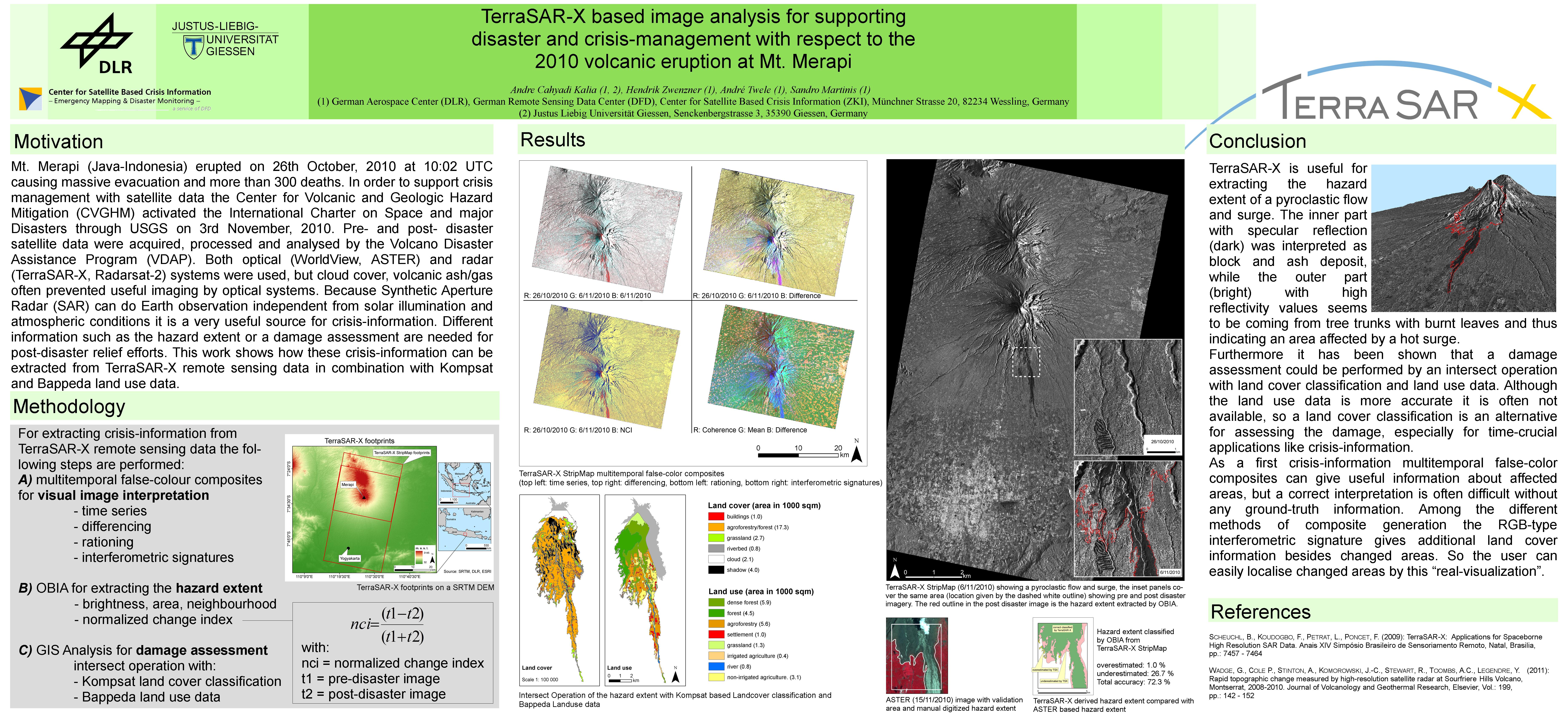 |
| Kapherr, Maximilian Felix (2011) Erfassung von lokalem Holzeinschlag in der Demokratischen Republik Kongo - Vergleich von pixel- und objektbasierten Klassifikationen und Veränderungsanalysen auf Grundlage optischer Satellitenbilddaten. Masterarbeit, DFD. Volltext nicht online. |
| Kersten, Jens und Gähler, Monika (2010) A Framework for Satellite Image Classification in the Context of Crisis Mapping Using Markov Random Fields. In: Proceedings of RSPSoc 2010 Annual Conference. RSPSoc 2010, 2010-08-31 - 2010-09-03, Cork, Irland. | |
| Kersten, Jens und Gähler, Monika und Voigt, Stefan (2010) A General Framework for Fast and Interactive Classification of Optical VHR Satellite Imagery Using Hierarchical and Planar Markov Random Fields. Photogrammetrie Fernerkundung Geoinformation (6), Seiten 443-453. E. Schweizerbartsche Verlagsbuchhandlung. doi: 10.1127/1432-8364/2010/0066. ISSN 1432-8364. Volltext nicht online. |
| Kersten, Jens (2011) Ein Rahmenwerk zur interaktiven Klassifikation hochauflösender optischer Satellitenbilder mittels graphenbasierter Bildmodellierung. Dissertation, Technische Universität Berlin. | |
| Kiefl, Ralph und Strobl, Christian und Henkel, Fabian und Riedlinger, Torsten (2009) Data management and SDI – Experiences from the GITEWS project. 33rd International Symposium on Remote Sensing of Environment (ISRSE), 2009-05-04 - 2009-05-08, Stresa, Italien. | |
| Klett, Stefan (2011) Rapid Mapping for Earthquake Disasters - A Team-based Method for Visual Damage Assessment Using Optical VHSR Satellite Data. Diplomarbeit, Universität Tübingen. | |
| Kussul, N. und Mandl, D. und Moe, K. und Mund, J. und Post, Joachim und Shelestov, A. und Skakun, S. und Szarzynski, J. und Van Langenhove, G. und Handy, M. (2012) Interoperable Infrastructure for Flood Monitoring: SensorWeb, Grid and Cloud. IEEE Journal of Selected Topics in Applied Earth Observations and Remote Sensing, 5 (6), Seiten 1740-1745. IEEE - Institute of Electrical and Electronics Engineers. doi: 10.1109/JSTARS.2012.2192417. ISSN 1939-1404. | |
| Lüthje, Fritjof (2011) Object-based image analysis using optical satellite imagery and GIS data for the detection of mining sites in the Democratic Republic of the Congo. Diplomarbeit, DFD. Volltext nicht online. |
| Martinis, Sandro (2010) Automatic near real-time flood detection in high resolution X-band synthetic aperture radar satellite data using context-based classification on irregular graphs. Dissertation, Ludwig-Maximilians-Universität München. Volltext nicht online. |
| Martinis, Sandro (2012) Automatic oil spill detection in TerraSAR-X data using multi-contextual Markov modeling on irregular graphs. 2012 3rd International Conference on Image Processing Theory, Tools and Applications, 2012-10-15 - 2012-10-18, Istanbul, Türkei. doi: 10.1109/IPTA.2012.6469508. ISBN 978-1-4673-2582-0. ISSN 2154-5111. Volltext nicht online. |
| Martinis, Sandro und Twele, André (2011) Unsupervised flood detection in X-band SAR data using multi-contextual Markov image modeling on irregular graphs. In: TerraSAR-X Science Team Meeting. 4. TerraSAR-X Science Team Meeting, 2011-02-14 - 2011-02-16, Oberpfaffenhofen. Volltext nicht online. |
| Martinis, Sandro und Twele, André und Gähler, Monika (2012) A multi-scale Markov model for unsupervised oil spill detection in TerraSAR-X data. In: International Geoscience and Remote Sensing Symposium (IGARSS), Seiten 923-926. IEEE International Geoscience and Remote Sensing Symposium (IGARSS) 2012, 2012-07-22 - 2012-07-27, München. doi: 10.1109/igarss.2012.6351405. ISBN 978-1-4673-1158-8. ISSN 2153-6996. Volltext nicht online. |
| Martinis, Sandro und Twele, André und Voigt, Stefan (2011) Unsupervised Extraction of Flood-Induced Backscatter Changes in SAR Data Using Markov Image Modeling on Irregular Graphs. IEEE Transactions on Geoscience and Remote Sensing, 49 (1), Seiten 251-263. IEEE - Institute of Electrical and Electronics Engineers. doi: 10.1109/TGRS.2010.2052816. ISSN 0196-2892. Volltext nicht online. |
| Martinis, Sandro (2021) International Charter Space and Major Disasters: Abschlussbericht 2019. Projektbericht. 41 S. Volltext nicht online. |
| Martinis, Sandro und Twele, André (2010) A Hierarchical Spatio-Temporal Markov Model for Improved Flood Mapping Using Multi-Temporal X-Band SAR Data. Remote Sensing, 2 (9), Seiten 2240-2258. Multidisciplinary Digital Publishing Institute (MDPI). doi: 10.3390/rs2092240. Volltext nicht online. |
| Martinis, Sandro und Twele, André (2010) Automatic Detection of Inundation-related Change Areas in TerraSAR-X Data Using Markov Image Modeling On Irregular Graphs. In: Geophysical Research Abstracts. Copernicus Publications. EGU General Assembly 2010, 2010-05-02 - 2010-05-07, Wien. | |
| Meyer, Anja (2012) Möglichkeiten der 3D-Visualisierung von Erdbebenschadensanalysen. Bachelorarbeit, Hochschule München. | |
| Muhari, Abdul und Imamura, Fumihiko und Koshimura, Sunchi und Post, Joachim (2011) Examination of three practical run-up models for assessing tsunami impact on highly populated areas. Natural Hazards and Earth System Sciences, 11, Seiten 3107-3123. Copernicus Publications. doi: 10.5194/nhess-11-3107-2011. | |
| Post, Joachim und Strunz, Günter und Hummel, Franz Maximilian und Benabdallah, Sihem und Prettentaler, Franz und Ludwig, Ralf (2012) Quantifying and reducing uncertainty in the assessment of water-related risks in southern Europe and neighbouring Countries. International Environmental Modelling and Software Society (iEMSs). International Environmental Modelling and Software Society (iEMSs). 2012 International Congress on Environmental Modelling and Software. Managing Resources of a Limited Planet, Sixth Biennial Meeting, Leipzig, Germany, 2012-07-01 - 2012-07-05, Leipzig. ISBN 978-88-9035-742-8. | |
| Post, Joachim und Strunz, Günter und Riedlinger, Torsten und Mück, Matthias und Wegscheider, Stephanie und Zosseder, Kai und Steinmetz, Tilmann und Gebert, Niklas und Anwar, Herryal Z. (2010) On the importance of risk knowledge for an end-to-end tsunami early warning system. EGU General Assembly 2010, 2010-05-02 - 2010-05-07, Wien, Österreich. | |
| Reinsch, Felix (2011) Auswirkungen des Flüchtlingscampwachstums auf die lokale Konfliktressource Holz. Masterarbeit, DFD. Volltext nicht online. |
| Rupp, Matthias (2011) Von der Einzel- zur Multi-Hazard-Analyse - Eine Untersuchung am Beispiel Cilacap, Java, Indonesien. Diplomarbeit, Ruprecht-Karls-Universität Heidelberg. | |
| Römer, Hannes und Zwenzner, Hendrik und Gähler, Monika und Voigt, Stefan (2011) A methodological framework for qualifying new thematic services for an implementation into SAFER emergency response and support services. In: Conference Proceedings, Seiten 97-104. Publication Office of the European Union. Third International workshop on Validation of geo-information products for crisis management (VALgEO), 2011-10-18 - 2011-10-19, Ispra, Italy. ISBN 978 92 79 21379 3. ISSN 1018-5593. | |
| Schneiderhan, Tobias (2012) A Quicker and Better Response to Crisis Situations. In: NEREUS publications NEREUS publications. Seiten 134-136. | |
| Schneiderhan, Tobias (2011) Führung in Krisensituationen – Am Beispiel des Zentrums für satellitengestützte Kriseninformation (ZKI). Masterarbeit, Wissenschaftliche Hochschule Lahr. Volltext nicht online. |
| Schneiderhan, Tobias und Clandillon, Stephen und Kranz, Olaf und Battiston, Stephanie (2011) GMES Emergency Response - Two years of EO-based Rapid Mapping. EC Directorate-General for Industry und Enterprise. Let's embrace space, 2011-05-12 - 2011-05-13, Budatpest, Ungarn. ISBN 978-92-79-19704-8. Volltext nicht online. |
| Schneiderhan, Tobias und Gähler, Monika und Kranz, Olaf und Voigt, Stefan (2010) Insights to the Emergency Mapping Service within the GMES project SAFER - Highlights, main achievements and challenges. In: Conference Proceedings, Seiten 1-5. Living Planet Symposium, 2010-06-28 - 2010-07-02, Bergen, Norwegen. | |
| Schoepfer, Elisabeth und Kranz, Olaf (2010) Monitoring natural resources in conflict using an object-based multiscale image analysis approach. In: ISPRS Proceedings (digital) of Geographic Object-Based Image Analysis (GEOBIA 2010), Vol. XXXVIII-4/C7, 29 June – 2 July 2010, Ghent (Belgium); ed. by Addink, E.A. & F.M.B. Van Coillie.. ISPRS. GEOBIA 2010, 2010-06-29 - 2010-07-02, Gent, Belgien. Volltext nicht online. |
| Schoepfer, Elisabeth und Kranz, Olaf (2010) Konfliktressourcen in der Demokratischen Republik Kongo - objektbasierte multiskalare Analyse von Erdbeobachtungsdaten zur Erfassung von Minenstandorten. In: Angewandte Geoinformatik 2010. Beiträge zum 22. AGIT-Symposium Salzburg, Seiten 911-916. Wichmann. AGIT 2010, 2010-07-07 - 2010-07-09, Salzburg, Österreich. ISBN 978-3-87907-495-2. | |
| Schwethelm, Felix (2010) Entwicklung eines semi-automatischen Ansatzes zur objektbasierten Extraktion von Wohneinheiten in Flüchtlingscamps in Darfur aus Erdbeobachtungsdaten. Diplomarbeit, DFD. Volltext nicht online. |
| Schönberg, Anke (2010) Land Cover Change Analysis around IDP/refugee Camps based on multitemporal MODIS Data in Sudan. Diplomarbeit, DFD. Volltext nicht online. |
| Spröhnle, Kristin und Kranz, Olaf und Schoepfer, Elisabeth (2010) Abschätzung der Umweltauswirkungen von Flüchtlings-lagern mit Hilfe multitemporaler Fernerkundungsdaten am Beispiel des Camps Zalingei in Westdarfur. In: Angewandte Geoinformatik 2010. Beiträge zum 22. AGIT-Symposium Salzburg, Seiten 697-702. Wichmann. AGIT 2010, 2010-07-07 - 2010-07-09, Salzburg, Österreich. ISBN 978-3-87907-495-2. Volltext nicht online. |
| Spröhnle, Kristin (2010) Earth Observation for Environmental Impact Assessment in the Surroundings of Refugee Camps in Darfur. Magisterarbeit, Universität Bamberg. Volltext nicht online. |
| Stark, Hans-Stefan (2011) Optimierung der Verfahren zur Aufbereitung krisenbezogener Fernerkundungs- und GIS- Daten des ZKI für ein webbasiertes Kriseninformationssystem. Bachelorarbeit, Hochschule München. Volltext nicht online. |
| Steinmetz, Tilmann und Raape, Ulrich und Teßmann, Sven und Strobl, Christian und Friedemann, Monika und Kukofka, Thomas und Riedlinger, Torsten und Mikusch, Eberhard und Dech, Stefan (2010) Tsunami early warning and decision support. Natural Hazards and Earth System Sciences, 10, Seiten 1839-1850. Copernicus Publications. doi: 10.5149/nhess-10-1839-2010. Volltext nicht online. |
| Strobl, Christian (2012) Workshop Fernerkundung mit Open Source Software. FOSSGIS 2012, 2012-03-19 - 2012-03-22, Dessau. Volltext nicht online. |
| Strunz, Günter und Post, Joachim und Zosseder, Kai und Wegscheider, Stephanie und Mück, Matthias und Riedlinger, Torsten und Mehl, Harald und Dech, Stefan und Birkmann, Jörn und Gebert, N. und Harjono, Hery und Anwar, Herryal Z. und Sumaryono, Sumaryono und Khomarudin, Rokhis M. und Muhari, Abdul (2011) Tsunami risk assessment in Indonesia. Natural Hazards and Earth System Sciences (11), Seiten 67-82. Copernicus Publications. doi: 10.5194/nhess-11-67-2011. ISSN 1561-8633. | |
| Twele, André und Martinis, Sandro und Hahmann, Thomas (2011) SAR-HQ - Methoden zur Erfassung und Analyse von großflächigen Hochwasserereignissen mittels hochauflösender Radardaten - Schlussbericht. Projektbericht. Deutsches Fernerkundungsdatenzentrum (DFD). 161 S. | |
| Van den Broek, Bert und Kiefl, Ralph und Riedlinger, Torsten und Scholte, Klaas und Granica, Klaus und Gutjahr, Karlheinz und Stephenne, Natalie und Binet, Renaud und De la Cruz, Antonio (2009) Rapid Mapping and Damage Assessment. In: Springer. Seiten 261-286. ISBN 978-1-4020-8483. Volltext nicht online. |
| Vatsavai, Ranga R. und Burk, Thomas E. und Lime, Steve und Hugentobler, Marco und Neumann, Andreas und Strobl, Christian (2012) Open-Source GIS. In: Springer Handbook of geographic Information Springer Handbook. Springer. Seiten 939-966. ISBN 978-3-540-72678-4. Volltext nicht online. |
| Voigt, Stefan und Schneiderhan, Tobias und Twele, André und Gähler, Monika und Stein, Enrico und Mehl, Harald (2011) Rapid Damage Assessment and Situation Mapping: Learning from the 2010 Haiti Earthquake. Photogrammetric Engineering and Remote Sensing (PE&RS), 77 (9), Seiten 923-931. American Society for Photogrammetry and Remote Sensing. doi: 10.14358/pers.77.9.923. ISSN 0099-1112. | |
| Wegscheider, Stephanie und Post, Joachim (2011) Satellite-based Crisis Information and Risk Assessment: Contributions Following the Earthquake in W. Sumatra and the Mentawai Tsunami. Earthzine. IEEE - Institute of Electrical and Electronics Engineers. Volltext nicht online. |
| Wegscheider, Stephanie und Post, Joachim und Mück, Matthias und Zosseder, Kai und Muhari, Abdul und Anwar, Herryal Z. und Gebert, Niklas und Strunz, Günter und Riedlinger, Torsten (2010) Generating tsunami risk knowledge at community level as a base for planning and implementation of risk reduction strategies. EGU General Assembly 2010, 2010-05-02 - 2010-05-07, Wien, Österreich. | |
| Wegscheider, Stephanie und Post, Joachim und Zosseder, Kai und Mück, Matthias und Strunz, Günter und Riedlinger, Torsten und Muhari, Abdul und Anwar, Herryal Z. (2010) Generating tsunami risk knowledge at community level as a base for planning and implementation of risk reduction strategies. Natural Hazards and Earth System Sciences, Seiten 249-258. Copernicus Publications. ISSN 1561-8633. | |
| Wiesner, Michael (2012) Entwicklung eines Index zur Bestimmung der räumlichen Zentralität von Städten basierend auf urbanen Fußabdrücken. Diplomarbeit, Julius-Maximilians-Universität Würzburg. Volltext nicht online. |
| Xiaoxuan , Yin (2011) Einsatz von Fernerkundungsdaten für die Bestimmung grundwasserhöffiger Gebiete in Flüchtlingsregionen Afrikas. Bachelorarbeit, DFD. Volltext nicht online. |